HiRISE DEM's |

HiRISE DEM's |
 Apr 13 2008, 10:46 AM Apr 13 2008, 10:46 AM
Post
#1
|
|||
|
Founder  Group: Chairman Posts: 14433 Joined: 8-February 04 Member No.: 1 |
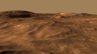
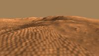
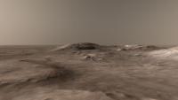
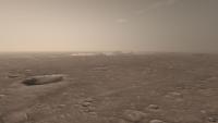
Late last week I stumbled upon a few HiRISE derived DEM's (Randy Kirk works his magic once again!)
http://webgis.wr.usgs.gov/ftphirise/index.jsp (URL now down) I'm working on both Vic Crater and the Columbia Hills. Fortunately, now I've got a Mac, I can use ISIS. I've figured out a fairly simple flow ( isis2raw as 16 bit unsigned, and then imported into Photoshop ) to take DEM CUB's and make 16 bit PNG's  Just to demo how important that is for me as an animator - sliced comparisons of 8bit vs 16 bit. A busy week unfortunately, but animations of various sorts are in the pipeline.
Attached thumbnail(s)
|
||
 |
 
|
||
 |
|
May 19 2008, 08:37 PM
Post
#2
|
|||
|
Founder Group: Chairman Posts: 14433 Joined: 8-February 04 Member No.: 1 |
The cliffs are a bit rounded off, just a symptom of the resolution (1m per 'pixel' for elevation) really.
And, to the very best of my abilities, they are accurate for elevation, as close as I could possibly make it. The clincher is that rendering the Columbia one from the landing site - it's a perfect replica of the success pan images of the hills. The proper movies are here - http://planetary.org/blog/article/00001423/ - although I intend to update the Columbia one later today - links later Randy Kirk got some nice emails about them, which is good because it's his hard work that made the data, and his kindness that put it 'out there' for nutters like me to play with.Doug
Attached thumbnail(s)
|
||
|
|
|
||
|
May 20 2008, 06:36 AM
Post
#3
|
|
 Senior Member Group: Members Posts: 2492 Joined: 15-January 05 From: center Italy Member No.: 150 |
QUOTE (djellison @ May 19 2008, 08:37 PM)  The proper movies are here - http://planetary.org/blog/article/00001423/ Now I can see them and are superb! Thanks. What do you think about adding a local high-res texture based on last panoramas, all around the MERs? I think this would add dramatic realism, reducing also the innatural contrast between rovers and smoothed DEM terrain... -------------------- I always think before posting! - Marco -
|
|
|
|
|
May 20 2008, 06:58 AM
Post
#4
|
|
|
Founder Group: Chairman Posts: 14433 Joined: 8-February 04 Member No.: 1 |
QUOTE (dilo @ May 20 2008, 07:36 AM) I think this would add dramatic realism Two problems with that. If I had, say, 1cm/pixel imagery around the rover - then my image map would have to be 1cm per pixel. There isn't an easy way to accurately place a second texture on top of the MRO one without actually making the whole thing 1cm pixel. That would mean a texture 800,000 pixels across. No cigar. I went down that road with CTX - on - HRSC DEM's. It was a bloody nightmare, and the results didn't pay off. The other problem is that at the moment, it all sits together quite nicely. Panoramas don't make good maps very easily.Only a few M from the rover, it's warped and distorted beyond the point of usefullness. ( for eg - http://pds-imaging.jpl.nasa.gov/data/mer2-...8l000m2.img.jpg ) and for the brief moment we are close to the rover, it wouldn't be worth the hassle. Adding terrain meshes to the Victoria crater one is something I've already had a look at ( I thought the capes might benefit ) but given up on. The meshes themselves just don't stand up to the level of quality to make it worth while. Always helps to actually publish the damn thing http://www.dougellison.com/?p=5 is now working. That, for now, is my last treatment of the Columbia one. What I'd REALLY REALLY love to be able to do, is some sort of realtime thing where you can drive around it on a quad bike. I'm sure Half Life 2 could manage it, but I just don't know how to put a million polygons into a game like that Doug |
|
|
|
|
May 21 2008, 10:26 AM
Post
#5
|
|
|
Senior Member Group: Members Posts: 2492 Joined: 15-January 05 From: center Italy Member No.: 150 |
Doug, I perfectly understand the issue you described, I had same problem when I tried to realize a "power of 10"-like movie initially showing all the red planed and then zooming on one rover (Emily suggested such idea long time ago, do you remember?).
Now I solved the issue by making a dedicated POV-RAY script who shades between various textures with different scales, anyway I abandoned the mars-zoom idea due to absence of time (for the moment!). Anyway, this idea is working well only if you strongly zoom on a planar surface, so is not applicable to your 3D DEM... I think the best way to avoid use of mega-textures is to overlap a local, texturized "mini_DEM" surface on the big one, eventually using 3D terrain model computed from MER stereo cam (someting like this was available on venerable "Maestro" JPL software... now I do not know where to find it). In the outer parts, such mini-DEM should appear progressively shaded in order to have a smooth transition effect. I know is not simple, it is only a suggestion for possible, future works... About your last treatment of the Columbia movie, I like it very much. My only observation is about the colors: personally, I would like more saturation, with different hue between red terrain and a yellow artificial sky...  What do you think about? What do you think about?
-------------------- I always think before posting! - Marco -
|
|
|
|
 djellison HiRISE DEM's Apr 13 2008, 10:46 AM
 Bjorn Jonsson QUOTE (djellison @ Apr 13 2008, 10:46 AM)... Apr 13 2008, 10:15 PM djellison Still figuring out the best way to explore and dis... Apr 14 2008, 10:41 AM djellison And using the Victoria one to simulate shadowing w... Apr 15 2008, 07:33 AM djellison I've had a hard time trying to do justice to t... Apr 20 2008, 07:30 PM djellison And Victoria crater
http://www.unmannedspacefligh... Apr 21 2008, 09:04 AM Stu Cooler than a penguin sat on an iceberg, sucking a... Apr 21 2008, 01:07 PM ilbasso Agree, very very cool!
All that's needed ... Apr 21 2008, 05:27 PM djellison I rendered a jumbo 4kx4k fisheye then polar-to-rec... May 5 2008, 01:14 PM djellison I hope you all enjoyed the movies at full res cour... May 15 2008, 11:24 AM djellison http://antwrp.gsfc.nasa.gov/apod/ap080519.html
Do... May 19 2008, 04:12 PM
Bjorn Jonsson QUOTE (djellison @ Apr 13 2008, 10:46 AM)... Apr 13 2008, 10:15 PM djellison Still figuring out the best way to explore and dis... Apr 14 2008, 10:41 AM djellison And using the Victoria one to simulate shadowing w... Apr 15 2008, 07:33 AM djellison I've had a hard time trying to do justice to t... Apr 20 2008, 07:30 PM djellison And Victoria crater
http://www.unmannedspacefligh... Apr 21 2008, 09:04 AM Stu Cooler than a penguin sat on an iceberg, sucking a... Apr 21 2008, 01:07 PM ilbasso Agree, very very cool!
All that's needed ... Apr 21 2008, 05:27 PM djellison I rendered a jumbo 4kx4k fisheye then polar-to-rec... May 5 2008, 01:14 PM djellison I hope you all enjoyed the movies at full res cour... May 15 2008, 11:24 AM djellison http://antwrp.gsfc.nasa.gov/apod/ap080519.html
Do... May 19 2008, 04:12 PM
 Del Palmer QUOTE (djellison @ May 19 2008, 05:12 PM)... May 19 2008, 09:19 PM Stu Well done! About time your work on these DEMs ... May 19 2008, 04:20 PM ustrax Magnifique! May 19 2008, 04:50 PM nprev Bra-VO!!! Superbly rendered...and a... May 19 2008, 05:05 PM djellison Just for fun, I actually have a better version on ... May 19 2008, 05:09 PM john_s These are great- nice job Doug!
I'm still... May 19 2008, 05:31 PM djellison Well - there are four done for various Phoenix sit... May 19 2008, 05:38 PM dilo Congrats, Doug!
Unfortunately, the movie is al... May 19 2008, 07:38 PM climber QUOTE (dilo @ May 19 2008, 09:38 PM) Unfo... May 20 2008, 07:31 AM climber Your work put everything in a new perspective and ... May 19 2008, 07:34 PM ngunn I thoroughly enjoyed seeing these on TPS - why did... May 19 2008, 08:03 PM djellison QUOTE (dilo @ May 21 2008, 11:26 AM) What... May 21 2008, 10:42 AM mhoward QUOTE (djellison @ May 21 2008, 04:42 AM)... May 21 2008, 12:04 PM Kevin QUOTE (djellison @ May 21 2008, 03:42 AM)... Jun 15 2008, 04:14 PM djellison I didn't know it had been posted on there. I ... May 19 2008, 10:14 PM djellison Finished thing is now here : http://www.dougelliso... May 19 2008, 11:19 PM ElkGroveDan Not found May 19 2008, 11:34 PM nprev Yeah, went hunting myself...no joy.
Did enjoy ... May 19 2008, 11:48 PM djellison I prepared this for someone else - thought forum p... Oct 13 2008, 09:18 PM thare For those that don't want to or can't inst... Nov 13 2008, 05:14 AM djellison Gale Crater dem up
http://www.dougellison.com/?p... Oct 19 2008, 06:02 PM mhoward OK, now that's cool. Oct 19 2008, 06:51 PM djellison Doing an updated 2009 version of my Columbia Hills... Sep 21 2009, 10:13 PM djellison FINISHED
http://www.dougellison.com/?p=82
Not p... Sep 22 2009, 08:13 PM Roby72 Like flying around - brilliant !
Robert Sep 22 2009, 08:54 PM elakdawalla Love the dusty quality of the atmosphere. An easy... Sep 22 2009, 09:22 PM PDP8E Hi Doug,
unbelievable job on the fly around! ... Sep 22 2009, 09:34 PM remcook I love how Spirit appears suddenly behind Home Pla... Sep 23 2009, 07:13 AM imipak Superb. Sep 23 2009, 08:15 AM antipode on Mars, on Mars, on Mars...
Thankyou.
p Sep 24 2009, 08:04 AM Stu QUOTE (antipode @ Sep 24 2009, 09:04 AM) ... Sep 24 2009, 01:40 PM ustrax Doug, that's just...beautiful. With all the be... Sep 24 2009, 02:19 PM climber I knew you were not going to sent the MER team ... Sep 24 2009, 04:38 PM JRA Great animation djellison. I really like it a lot.... Sep 25 2009, 02:50 AM elakdawalla I haven't tried to work with the DEM data at a... Sep 25 2009, 04:06 AM JRA The file is 16-bit. And the histogram seems to be ... Sep 25 2009, 04:16 AM elakdawalla Well that's pretty much all my ideas. Guess y... Sep 25 2009, 04:32 AM djellison This is the only way I know - so far - and it... Sep 25 2009, 07:33 AM djellison 1080 Full HD version
http://www.archive.org/detail... Sep 25 2009, 02:45 PM PhilCo126 Superb work Doug, it didn't go unnoticed on ot... Sep 25 2009, 04:57 PM djellison Nancy talked about it on Universe Today, Emily did... Sep 25 2009, 05:05 PM SFJCody Beautiful work as ever. Sep 25 2009, 06:53 PM stevesliva QUOTE (djellison @ Sep 25 2009, 12:05 PM)... Oct 3 2009, 05:44 AM tharrison NASA Ames is working on a stereo pipeline for auto... Jan 10 2010, 11:10 PM Zack Moratto QUOTE (tharrison @ Jan 10 2010, 03:10 PM)... Jan 24 2010, 08:11 AM tharrison QUOTE (Zack Moratto @ Jan 24 2010, 12:11 ... Jan 24 2010, 07:45 PM Zack Moratto Okay fine. I'll bug Trent next week when I see... Jan 25 2010, 05:53 AM tharrison Trent got in touch with our software folks this mo... Jan 25 2010, 06:26 PM elakdawalla Is this news?
First PDS Release of HiRISE DTMs
D... Jan 21 2010, 02:35 AM Nirgal QUOTE (elakdawalla @ Jan 21 2010, 03:35 A... Jan 21 2010, 01:29 PM ElkGroveDan If you view any of those fly-overs, be sure and se... Jan 21 2010, 03:02 PM charborob Not having the knowledge nor the time to make use ... Jan 21 2010, 04:50 PM djellison I've picked four favorites from the new batch ... Jan 24 2010, 10:16 AM djellison The results of processing the new HiRISE team DEM... Jan 27 2010, 03:36 PM Nirgal QUOTE (djellison @ Jan 27 2010, 04:36 PM)... Jan 27 2010, 10:21 PM Vultur Interesting how there's a crater right on top ... Jan 27 2010, 04:11 PM remcook Still pretty wow ! Jan 27 2010, 04:31 PM elakdawalla Wow there's a lot of texture in those DEMs... Jan 27 2010, 05:22 PM Mars3D Here's a couple of images created from the new... Jan 27 2010, 06:04 PM djellison It's done in the renderer as required by each ... Jan 27 2010, 10:42 PM Bjorn Jonsson QUOTE (djellison @ Jan 27 2010, 10:42 PM)... Jan 28 2010, 01:29 AM nprev Man, am I glad I finally got a new computer for Ch... Jan 27 2010, 10:43 PM djellison Update : - Gale Crater uploaded
http://www.youtube... Jan 27 2010, 10:52 PM The Singing Badger Dude, you made it onto the Huffington Post!
h... Jan 27 2010, 11:18 PM belleraphon1 TOTALLY AWESOME.
Gold standard Forum this is... Jan 28 2010, 12:49 AM djellison I think it's being selective in not generating... Jan 28 2010, 07:28 AM charborob Its interesting to compare Doug's Mojave crate... Jan 28 2010, 02:33 PM djellison Interesting in what way Good/bad/indiferent Jan 28 2010, 06:08 PM helvick I prefer your lighting, and you have a better flig... Jan 28 2010, 07:46 PM charborob Doug, your animations are great. The flyover on th... Jan 28 2010, 08:38 PM djellison Two more - http://www.youtube.com/watch?v=wswCRehr... Jan 29 2010, 07:17 PM pgrindrod they are sweet doug - well done!
take a break... Jan 29 2010, 07:54 PM climber I believe I can fly.
Thanks Doug. Jan 29 2010, 08:16 PM Poolio Finally got the chance to watch these full screen ... Jan 30 2010, 07:23 PM djellison Just getting the data that Pete helped me make (in... Feb 1 2010, 02:35 PM elakdawalla I'd amend that to
early results = awesome... Feb 1 2010, 05:47 PM charborob If this is only "early results", I can... Feb 1 2010, 06:10 PM djellison It's rendering now. Start with Pathfinder pan... Feb 1 2010, 06:16 PM djellison Time for DEM hatrick....
One of Pete Grindrod... Feb 2 2010, 11:23 AM charborob Fantastic animations! Congratulations, Doug... Feb 2 2010, 02:11 PM ElkGroveDan Go ahead and take the rest of the week off Doug an... Feb 2 2010, 02:38 PM djellison When I first popped the pathfinder pan back over t... Feb 2 2010, 02:49 PM hendric Doug,
Simply amazing. When you redo this one, c... Feb 2 2010, 03:36 PM djellison I'm doing a MAJOR 2.0 that's quite differe... Feb 2 2010, 04:24 PM eoincampbell For some reason only Quicktime wants to play it sm... Feb 2 2010, 06:23 PM
Del Palmer QUOTE (djellison @ May 19 2008, 05:12 PM)... May 19 2008, 09:19 PM Stu Well done! About time your work on these DEMs ... May 19 2008, 04:20 PM ustrax Magnifique! May 19 2008, 04:50 PM nprev Bra-VO!!! Superbly rendered...and a... May 19 2008, 05:05 PM djellison Just for fun, I actually have a better version on ... May 19 2008, 05:09 PM john_s These are great- nice job Doug!
I'm still... May 19 2008, 05:31 PM djellison Well - there are four done for various Phoenix sit... May 19 2008, 05:38 PM dilo Congrats, Doug!
Unfortunately, the movie is al... May 19 2008, 07:38 PM climber QUOTE (dilo @ May 19 2008, 09:38 PM) Unfo... May 20 2008, 07:31 AM climber Your work put everything in a new perspective and ... May 19 2008, 07:34 PM ngunn I thoroughly enjoyed seeing these on TPS - why did... May 19 2008, 08:03 PM djellison QUOTE (dilo @ May 21 2008, 11:26 AM) What... May 21 2008, 10:42 AM mhoward QUOTE (djellison @ May 21 2008, 04:42 AM)... May 21 2008, 12:04 PM Kevin QUOTE (djellison @ May 21 2008, 03:42 AM)... Jun 15 2008, 04:14 PM djellison I didn't know it had been posted on there. I ... May 19 2008, 10:14 PM djellison Finished thing is now here : http://www.dougelliso... May 19 2008, 11:19 PM ElkGroveDan Not found May 19 2008, 11:34 PM nprev Yeah, went hunting myself...no joy.
Did enjoy ... May 19 2008, 11:48 PM djellison I prepared this for someone else - thought forum p... Oct 13 2008, 09:18 PM thare For those that don't want to or can't inst... Nov 13 2008, 05:14 AM djellison Gale Crater dem up
http://www.dougellison.com/?p... Oct 19 2008, 06:02 PM mhoward OK, now that's cool. Oct 19 2008, 06:51 PM djellison Doing an updated 2009 version of my Columbia Hills... Sep 21 2009, 10:13 PM djellison FINISHED
http://www.dougellison.com/?p=82
Not p... Sep 22 2009, 08:13 PM Roby72 Like flying around - brilliant !
Robert Sep 22 2009, 08:54 PM elakdawalla Love the dusty quality of the atmosphere. An easy... Sep 22 2009, 09:22 PM PDP8E Hi Doug,
unbelievable job on the fly around! ... Sep 22 2009, 09:34 PM remcook I love how Spirit appears suddenly behind Home Pla... Sep 23 2009, 07:13 AM imipak Superb. Sep 23 2009, 08:15 AM antipode on Mars, on Mars, on Mars...
Thankyou.
p Sep 24 2009, 08:04 AM Stu QUOTE (antipode @ Sep 24 2009, 09:04 AM) ... Sep 24 2009, 01:40 PM ustrax Doug, that's just...beautiful. With all the be... Sep 24 2009, 02:19 PM climber I knew you were not going to sent the MER team ... Sep 24 2009, 04:38 PM JRA Great animation djellison. I really like it a lot.... Sep 25 2009, 02:50 AM elakdawalla I haven't tried to work with the DEM data at a... Sep 25 2009, 04:06 AM JRA The file is 16-bit. And the histogram seems to be ... Sep 25 2009, 04:16 AM elakdawalla Well that's pretty much all my ideas. Guess y... Sep 25 2009, 04:32 AM djellison This is the only way I know - so far - and it... Sep 25 2009, 07:33 AM djellison 1080 Full HD version
http://www.archive.org/detail... Sep 25 2009, 02:45 PM PhilCo126 Superb work Doug, it didn't go unnoticed on ot... Sep 25 2009, 04:57 PM djellison Nancy talked about it on Universe Today, Emily did... Sep 25 2009, 05:05 PM SFJCody Beautiful work as ever. Sep 25 2009, 06:53 PM stevesliva QUOTE (djellison @ Sep 25 2009, 12:05 PM)... Oct 3 2009, 05:44 AM tharrison NASA Ames is working on a stereo pipeline for auto... Jan 10 2010, 11:10 PM Zack Moratto QUOTE (tharrison @ Jan 10 2010, 03:10 PM)... Jan 24 2010, 08:11 AM tharrison QUOTE (Zack Moratto @ Jan 24 2010, 12:11 ... Jan 24 2010, 07:45 PM Zack Moratto Okay fine. I'll bug Trent next week when I see... Jan 25 2010, 05:53 AM tharrison Trent got in touch with our software folks this mo... Jan 25 2010, 06:26 PM elakdawalla Is this news?
First PDS Release of HiRISE DTMs
D... Jan 21 2010, 02:35 AM Nirgal QUOTE (elakdawalla @ Jan 21 2010, 03:35 A... Jan 21 2010, 01:29 PM ElkGroveDan If you view any of those fly-overs, be sure and se... Jan 21 2010, 03:02 PM charborob Not having the knowledge nor the time to make use ... Jan 21 2010, 04:50 PM djellison I've picked four favorites from the new batch ... Jan 24 2010, 10:16 AM djellison The results of processing the new HiRISE team DEM... Jan 27 2010, 03:36 PM Nirgal QUOTE (djellison @ Jan 27 2010, 04:36 PM)... Jan 27 2010, 10:21 PM Vultur Interesting how there's a crater right on top ... Jan 27 2010, 04:11 PM remcook Still pretty wow ! Jan 27 2010, 04:31 PM elakdawalla Wow there's a lot of texture in those DEMs... Jan 27 2010, 05:22 PM Mars3D Here's a couple of images created from the new... Jan 27 2010, 06:04 PM djellison It's done in the renderer as required by each ... Jan 27 2010, 10:42 PM Bjorn Jonsson QUOTE (djellison @ Jan 27 2010, 10:42 PM)... Jan 28 2010, 01:29 AM nprev Man, am I glad I finally got a new computer for Ch... Jan 27 2010, 10:43 PM djellison Update : - Gale Crater uploaded
http://www.youtube... Jan 27 2010, 10:52 PM The Singing Badger Dude, you made it onto the Huffington Post!
h... Jan 27 2010, 11:18 PM belleraphon1 TOTALLY AWESOME.
Gold standard Forum this is... Jan 28 2010, 12:49 AM djellison I think it's being selective in not generating... Jan 28 2010, 07:28 AM charborob Its interesting to compare Doug's Mojave crate... Jan 28 2010, 02:33 PM djellison Interesting in what way Good/bad/indiferent Jan 28 2010, 06:08 PM helvick I prefer your lighting, and you have a better flig... Jan 28 2010, 07:46 PM charborob Doug, your animations are great. The flyover on th... Jan 28 2010, 08:38 PM djellison Two more - http://www.youtube.com/watch?v=wswCRehr... Jan 29 2010, 07:17 PM pgrindrod they are sweet doug - well done!
take a break... Jan 29 2010, 07:54 PM climber I believe I can fly.
Thanks Doug. Jan 29 2010, 08:16 PM Poolio Finally got the chance to watch these full screen ... Jan 30 2010, 07:23 PM djellison Just getting the data that Pete helped me make (in... Feb 1 2010, 02:35 PM elakdawalla I'd amend that to
early results = awesome... Feb 1 2010, 05:47 PM charborob If this is only "early results", I can... Feb 1 2010, 06:10 PM djellison It's rendering now. Start with Pathfinder pan... Feb 1 2010, 06:16 PM djellison Time for DEM hatrick....
One of Pete Grindrod... Feb 2 2010, 11:23 AM charborob Fantastic animations! Congratulations, Doug... Feb 2 2010, 02:11 PM ElkGroveDan Go ahead and take the rest of the week off Doug an... Feb 2 2010, 02:38 PM djellison When I first popped the pathfinder pan back over t... Feb 2 2010, 02:49 PM hendric Doug,
Simply amazing. When you redo this one, c... Feb 2 2010, 03:36 PM djellison I'm doing a MAJOR 2.0 that's quite differe... Feb 2 2010, 04:24 PM eoincampbell For some reason only Quicktime wants to play it sm... Feb 2 2010, 06:23 PM |

|
Lo-Fi Version | Time is now: 14th June 2024 - 06:07 AM |
|
RULES AND GUIDELINES Please read the Forum Rules and Guidelines before posting. IMAGE COPYRIGHT |
OPINIONS AND MODERATION Opinions expressed on UnmannedSpaceflight.com are those of the individual posters and do not necessarily reflect the opinions of UnmannedSpaceflight.com or The Planetary Society. The all-volunteer UnmannedSpaceflight.com moderation team is wholly independent of The Planetary Society. The Planetary Society has no influence over decisions made by the UnmannedSpaceflight.com moderators. |
SUPPORT THE FORUM Unmannedspaceflight.com is funded by the Planetary Society. Please consider supporting our work and many other projects by donating to the Society or becoming a member. |
|