Whole Earth images, Does any satellite provide regularly updated ones? |

Whole Earth images, Does any satellite provide regularly updated ones? |
 Mar 8 2007, 04:17 PM Mar 8 2007, 04:17 PM
Post
#1
|
|
 Administrator  Group: Admin Posts: 5172 Joined: 4-August 05 From: Pasadena, CA, USA, Earth Member No.: 454 |
There are tons of Earth observing satellites producing gorgeous detailed images, but I'm trying to figure out if any of them is capable of producing full-globe images of Earth on some regularly updated basis. Does anyone here know of such a beast? Are there weather monitoring satellites that do this?
--Emily -------------------- My website - My Patreon - @elakdawalla on Twitter - Please support unmannedspaceflight.com by donating here.
|
 |
 
|
 |
|
Jul 6 2008, 08:51 PM
Post
#2
|
||
 Senior Member Group: Moderator Posts: 2785 Joined: 10-November 06 From: Pasadena, CA Member No.: 1345 |
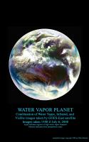
Combination of Water Vapor (primarily), Infrared, and Visible images from the GOES-East geostationary satellite. These images were downloaded from the Dundee Receiving Station website today (images for July 6, 20081500 UTC)
Aqua and blue tones indicates higher levels of water vapor, while maroon tones indicate drier air. In the central Atlantic, Tropical Storm Bertha can be seen leaving a trail of clouds to the east as it pumps water vapor into the atmosphere. -Mike -------------------- Some higher resolution images available at my photostream: http://www.flickr.com/photos/31678681@N07/
|
|
|
|
|
|
|
Jul 6 2008, 08:58 PM
Post
#3
|
|
 Senior Member Group: Members Posts: 3648 Joined: 1-October 05 From: Croatia Member No.: 523 |
Ooh... funky stuff!
-------------------- |
|
|
|
|
Aug 3 2008, 01:02 AM
Post
#4
|
|
|
Member Group: Members Posts: 194 Joined: 8-February 04 Member No.: 10 |
Thanks to Robert Beal of the John Hopkins Applied Physics Lab, I now have on my site a copy of the first color image of the Earth as a disk. It was made September 20, 1967 by the Department Of Defense Gravity Experiment satellite (DODGE). He worked on the mission, painting the spherical color target at the end of the boom and photographically assembling the color image. Beal sent me a file based on a print he made, which he had color balanced to resemble the ATS Earth image on my site. Upon my request he reconstructed the color scheme of the poorly imaged target from memory. I was told the colors used, similar in philosophy to Surveyor, were radiation resistant paints which happened to be of low saturation. The idea of a spherical color target is interesting, and strikes me as ingenious. If both target and background are sunlit the target can supply useful information at a wide range of lighting angles. Has this method been used in other camera carrying spacecraft?
In a separate version I have repainted the color target, fixing the motion blur in the boom in the blue channel, and tried to 'fine tune' the Autochrome like image into a kind of 'reconstruction' of how it might have appeared if all imaging steps worked ideally. http://www.donaldedavis.com/2003NEW/NEWSTUFF/DDEARTH.html Don |
|
|
|
 elakdawalla Whole Earth images Mar 8 2007, 04:17 PM
 djellison Well - there's Meteosat, the European geostati... Mar 8 2007, 04:32 PM
 tedstryk Modis covers the entire earth every one to two day... Mar 8 2007, 04:46 PM tedstryk On second thought, Emily, you are breaking the law... Mar 8 2007, 04:47 PM Juramike This will get you the "other" side of th... Mar 8 2007, 04:39 PM stevesliva You'd have to be pretty far out there to fit t... Mar 8 2007, 04:40 PM Pando QUOTE (stevesliva @ Mar 8 2007, 08:40 AM)... Mar 9 2007, 01:53 AM Tom Womack I think you could get full-globe images by combini... Mar 8 2007, 04:44 PM djellison Thought I would see just how hard it is to merge a... Mar 8 2007, 04:47 PM ngunn QUOTE (djellison @ Mar 8 2007, 04:47 PM) ... Mar 8 2007, 10:25 PM elakdawalla I'm asking this question on behalf of Lou, and... Mar 8 2007, 04:49 PM djellison Again...TEEEeeechnnically - one could take one of ... Mar 8 2007, 04:53 PM tedstryk I want to make a comment here, but I can't wit... Mar 8 2007, 05:16 PM helvick QUOTE ... the only global image of the earth is th... Mar 8 2007, 05:18 PM climber This is one of the more inspiring Earth image to m... Mar 9 2007, 09:39 AM remcook a shame it's not a real image. Would be nice t... Mar 9 2007, 10:22 AM Juramike I wonder if one could see the shadow resulting fro... Mar 9 2007, 04:25 PM remcook ISS sure had a good look: e.g.
http://www.nasa.gov... Mar 9 2007, 04:35 PM Juramike Very cool! I hadn't seen that before. Th... Mar 9 2007, 06:51 PM Hari I create global cloud mosaics for the xplanet proj... Mar 13 2007, 02:56 PM neave EUMESAT is a geo-stationary satellite with full di... Mar 13 2007, 03:08 PM scalbers For clouds this is one of the things I'm worki... Apr 21 2007, 11:40 PM edstrick The fundamental problem is that there are no space... Apr 22 2007, 07:52 AM DDAVIS I used to make Earth textures from weather sats us... Apr 22 2007, 09:12 AM scalbers Greetings,
I can show a somewhat dated example of... Apr 22 2007, 02:15 PM helvick Steve that is stunning.
Will the newer version b... Apr 22 2007, 02:24 PM DDAVIS In a recent update to my Earth texture I added gas... Apr 22 2007, 03:03 PM scalbers Helvick - glad the animation played OK for you. I... Apr 22 2007, 03:23 PM edstrick "...I think the geostationary satellites see ... Apr 24 2007, 09:21 AM ElGrifon WOW those are just incredable images of the Earth,... Apr 27 2007, 12:46 AM djellison Just to fill up this thread appropriately - from t... Apr 27 2007, 07:31 AM belleraphon1 WOW..
These whole Earth images from departing and... May 2 2007, 12:00 PM elakdawalla I totally forgot to return to this thread after cr... May 2 2007, 04:10 PM lyford Nice collection, Emily.
I keep forgetting there... May 2 2007, 06:10 PM scalbers Yes - excellent website Emily. Nice summary of the... May 5 2007, 02:51 PM djellison The page has been updated with my Galileo efforts ... May 9 2007, 07:21 AM Phil Stooke Don't forget Lunar Orbiter, Surveyor and the Z... May 9 2007, 12:43 PM ljk4-1 The Japanese Mars probe Nozomi also took images of... May 9 2007, 01:10 PM AlexBlackwell NEAR Shoemaker during the 1998 Earth swingby May 9 2007, 09:52 PM djellison I plan to do to NEAR what I've done to the Gal... May 10 2007, 01:36 PM tedstryk Great Galileo work, Doug.
By the way, there are... May 11 2007, 01:40 PM ugordan Wow, awesome, Ted! May 11 2007, 01:54 PM tedstryk Emily, you are welcome to add this to the planetar... May 14 2007, 02:08 PM elakdawalla QUOTE (tedstryk @ May 14 2007, 07:08 AM) ... May 14 2007, 03:00 PM ugordan I see Doug's Galileo Earth rotation made APOD ... May 14 2007, 11:54 AM djellison It's a specular reflection off a lake in Uragu... May 14 2007, 01:31 PM ugordan I thought about a lake specular, the specular poin... May 14 2007, 01:39 PM djellison It's not packed solid cloud though - it's ... May 14 2007, 02:18 PM Phil Stooke Just to clarify one point, Ted's Earthrise is ... May 14 2007, 03:23 PM tedstryk Doug: Congratulations!
Phil: I had no idea.... May 14 2007, 03:47 PM tedstryk Here we are then...
Full Resolution May 14 2007, 03:58 PM DDAVIS In images 2 and 4 of the Zond sequence the Lunar h... May 27 2007, 01:40 AM tedstryk It is actually image 2 that isn't a valid part... May 27 2007, 02:00 AM Ant103 It's not a whole Earth picture but it's of... Jul 20 2007, 01:26 PM climber QUOTE (Ant103 @ Jul 20 2007, 03:26 PM) It... Jul 20 2007, 07:27 PM CAP-Team this link works Jul 20 2007, 08:53 PM LivingNDixie This is one of my favorites, it makes a great wall... Jul 23 2007, 04:51 PM djellison That's just renered from the Blue Marble data ... Jul 23 2007, 08:37 PM MouseOnMars The Japanese GMS-5 satellite used to produce full ... Jul 23 2007, 11:13 PM scalbers Hi - there are a few images collected by NASA at t... Oct 9 2007, 03:16 PM ugordan Great resource, Steve! Images I hadn't see... Oct 9 2007, 04:50 PM MouseOnMars QUOTE (scalbers @ Oct 9 2007, 04:16 PM) H... Oct 9 2007, 07:59 PM ljk4-1 Twin Blue Marbles
http://earthobservatory.nasa.go... Oct 10 2007, 07:31 PM Stu Those new Twin Blue Marble images are just spectac... Oct 10 2007, 09:12 PM ustrax QUOTE (Stu @ Oct 10 2007, 10:12 PM) Those... Oct 10 2007, 10:01 PM n1ckdrake This is one of my favorites.
Nov 25 2007, 06:49 AM dilo Cool picture, n1ckdrake! Which source/mission?... Nov 25 2007, 05:53 PM Paolo QUOTE (dilo @ Nov 25 2007, 06:53 PM) Cool... Nov 25 2007, 06:50 PM remcook oeee is that a Kelvin wave? Cool! Nov 25 2007, 08:00 PM n1ckdrake The photo of the Earth is from the Apollo 10 missi... Nov 26 2007, 03:27 AM dvandorn QUOTE (n1ckdrake @ Nov 25 2007, 09:27 PM)... Nov 26 2007, 05:17 AM n1ckdrake This image is from the Apollo 16 mission.
Link Nov 26 2007, 04:10 AM dvandorn QUOTE (n1ckdrake @ Nov 25 2007, 10:10 PM)... Nov 26 2007, 05:20 AM peter59 This image is from the Mariner-10 spacecraft.
Im... Dec 29 2007, 04:04 PM ugordan Here's a montage of Earth and Moon from MESSEN... Feb 5 2008, 02:59 PM Stu QUOTE (ugordan @ Feb 5 2008, 02:59 PM) He... Feb 9 2008, 08:39 AM ugordan You're welcome, Stu! Feb 9 2008, 05:16 PM Stu Oh my....
"Beautiful" doesn't even ... Feb 5 2008, 03:23 PM djellison I wonder if, with the Dawn flyby - we might get a ... Feb 5 2008, 03:24 PM ugordan Now that you mention it, the Mercury image and thi... Feb 5 2008, 03:41 PM rogelio Nice picture, ugordan.
Are those smoke plumes fro... Feb 5 2008, 03:54 PM charborob Very nice image, except the Moon is not in its cor... Feb 5 2008, 04:12 PM ugordan QUOTE (charborob @ Feb 5 2008, 05:12 PM) ... Feb 5 2008, 04:19 PM tedstryk Amazing! Feb 5 2008, 05:15 PM Pertinax QUOTE (ugordan @ Feb 5 2008, 12:19 PM) Ro... Aug 4 2008, 03:50 PM centsworth_II QUOTE (charborob @ Feb 5 2008, 11:12 AM) ... Feb 5 2008, 06:23 PM Ant103 Good god
I've found the desktop wallpaper of ... Feb 5 2008, 05:42 PM remcook amazing work as usual! Feb 5 2008, 06:28 PM Juramike Thank y'all for this thread!
Using thes... Feb 8 2008, 12:07 PM Stu That's quite a coup you have there, well done.... Aug 3 2008, 07:13 AM Juramike Animated loop of the Atlantic Basin of the Earth f... Aug 21 2008, 02:51 AM PhilCo126 Nice picture, ugordan, Moon orientation a bit too ... Aug 21 2008, 06:19 PM hendric Juramike,
The best places for weather discussion... Aug 21 2008, 07:28 PM Juramike Weather Underground is a great site. I'm a hu... Aug 21 2008, 10:24 PM jamescanvin Images of storms are rather off topic for this thr... Sep 15 2008, 07:33 AM
tedstryk Modis covers the entire earth every one to two day... Mar 8 2007, 04:46 PM tedstryk On second thought, Emily, you are breaking the law... Mar 8 2007, 04:47 PM Juramike This will get you the "other" side of th... Mar 8 2007, 04:39 PM stevesliva You'd have to be pretty far out there to fit t... Mar 8 2007, 04:40 PM Pando QUOTE (stevesliva @ Mar 8 2007, 08:40 AM)... Mar 9 2007, 01:53 AM Tom Womack I think you could get full-globe images by combini... Mar 8 2007, 04:44 PM djellison Thought I would see just how hard it is to merge a... Mar 8 2007, 04:47 PM ngunn QUOTE (djellison @ Mar 8 2007, 04:47 PM) ... Mar 8 2007, 10:25 PM elakdawalla I'm asking this question on behalf of Lou, and... Mar 8 2007, 04:49 PM djellison Again...TEEEeeechnnically - one could take one of ... Mar 8 2007, 04:53 PM tedstryk I want to make a comment here, but I can't wit... Mar 8 2007, 05:16 PM helvick QUOTE ... the only global image of the earth is th... Mar 8 2007, 05:18 PM climber This is one of the more inspiring Earth image to m... Mar 9 2007, 09:39 AM remcook a shame it's not a real image. Would be nice t... Mar 9 2007, 10:22 AM Juramike I wonder if one could see the shadow resulting fro... Mar 9 2007, 04:25 PM remcook ISS sure had a good look: e.g.
http://www.nasa.gov... Mar 9 2007, 04:35 PM Juramike Very cool! I hadn't seen that before. Th... Mar 9 2007, 06:51 PM Hari I create global cloud mosaics for the xplanet proj... Mar 13 2007, 02:56 PM neave EUMESAT is a geo-stationary satellite with full di... Mar 13 2007, 03:08 PM scalbers For clouds this is one of the things I'm worki... Apr 21 2007, 11:40 PM edstrick The fundamental problem is that there are no space... Apr 22 2007, 07:52 AM DDAVIS I used to make Earth textures from weather sats us... Apr 22 2007, 09:12 AM scalbers Greetings,
I can show a somewhat dated example of... Apr 22 2007, 02:15 PM helvick Steve that is stunning.
Will the newer version b... Apr 22 2007, 02:24 PM DDAVIS In a recent update to my Earth texture I added gas... Apr 22 2007, 03:03 PM scalbers Helvick - glad the animation played OK for you. I... Apr 22 2007, 03:23 PM edstrick "...I think the geostationary satellites see ... Apr 24 2007, 09:21 AM ElGrifon WOW those are just incredable images of the Earth,... Apr 27 2007, 12:46 AM djellison Just to fill up this thread appropriately - from t... Apr 27 2007, 07:31 AM belleraphon1 WOW..
These whole Earth images from departing and... May 2 2007, 12:00 PM elakdawalla I totally forgot to return to this thread after cr... May 2 2007, 04:10 PM lyford Nice collection, Emily.
I keep forgetting there... May 2 2007, 06:10 PM scalbers Yes - excellent website Emily. Nice summary of the... May 5 2007, 02:51 PM djellison The page has been updated with my Galileo efforts ... May 9 2007, 07:21 AM Phil Stooke Don't forget Lunar Orbiter, Surveyor and the Z... May 9 2007, 12:43 PM ljk4-1 The Japanese Mars probe Nozomi also took images of... May 9 2007, 01:10 PM AlexBlackwell NEAR Shoemaker during the 1998 Earth swingby May 9 2007, 09:52 PM djellison I plan to do to NEAR what I've done to the Gal... May 10 2007, 01:36 PM tedstryk Great Galileo work, Doug.
By the way, there are... May 11 2007, 01:40 PM ugordan Wow, awesome, Ted! May 11 2007, 01:54 PM tedstryk Emily, you are welcome to add this to the planetar... May 14 2007, 02:08 PM elakdawalla QUOTE (tedstryk @ May 14 2007, 07:08 AM) ... May 14 2007, 03:00 PM ugordan I see Doug's Galileo Earth rotation made APOD ... May 14 2007, 11:54 AM djellison It's a specular reflection off a lake in Uragu... May 14 2007, 01:31 PM ugordan I thought about a lake specular, the specular poin... May 14 2007, 01:39 PM djellison It's not packed solid cloud though - it's ... May 14 2007, 02:18 PM Phil Stooke Just to clarify one point, Ted's Earthrise is ... May 14 2007, 03:23 PM tedstryk Doug: Congratulations!
Phil: I had no idea.... May 14 2007, 03:47 PM tedstryk Here we are then...
Full Resolution May 14 2007, 03:58 PM DDAVIS In images 2 and 4 of the Zond sequence the Lunar h... May 27 2007, 01:40 AM tedstryk It is actually image 2 that isn't a valid part... May 27 2007, 02:00 AM Ant103 It's not a whole Earth picture but it's of... Jul 20 2007, 01:26 PM climber QUOTE (Ant103 @ Jul 20 2007, 03:26 PM) It... Jul 20 2007, 07:27 PM CAP-Team this link works Jul 20 2007, 08:53 PM LivingNDixie This is one of my favorites, it makes a great wall... Jul 23 2007, 04:51 PM djellison That's just renered from the Blue Marble data ... Jul 23 2007, 08:37 PM MouseOnMars The Japanese GMS-5 satellite used to produce full ... Jul 23 2007, 11:13 PM scalbers Hi - there are a few images collected by NASA at t... Oct 9 2007, 03:16 PM ugordan Great resource, Steve! Images I hadn't see... Oct 9 2007, 04:50 PM MouseOnMars QUOTE (scalbers @ Oct 9 2007, 04:16 PM) H... Oct 9 2007, 07:59 PM ljk4-1 Twin Blue Marbles
http://earthobservatory.nasa.go... Oct 10 2007, 07:31 PM Stu Those new Twin Blue Marble images are just spectac... Oct 10 2007, 09:12 PM ustrax QUOTE (Stu @ Oct 10 2007, 10:12 PM) Those... Oct 10 2007, 10:01 PM n1ckdrake This is one of my favorites.
Nov 25 2007, 06:49 AM dilo Cool picture, n1ckdrake! Which source/mission?... Nov 25 2007, 05:53 PM Paolo QUOTE (dilo @ Nov 25 2007, 06:53 PM) Cool... Nov 25 2007, 06:50 PM remcook oeee is that a Kelvin wave? Cool! Nov 25 2007, 08:00 PM n1ckdrake The photo of the Earth is from the Apollo 10 missi... Nov 26 2007, 03:27 AM dvandorn QUOTE (n1ckdrake @ Nov 25 2007, 09:27 PM)... Nov 26 2007, 05:17 AM n1ckdrake This image is from the Apollo 16 mission.
Link Nov 26 2007, 04:10 AM dvandorn QUOTE (n1ckdrake @ Nov 25 2007, 10:10 PM)... Nov 26 2007, 05:20 AM peter59 This image is from the Mariner-10 spacecraft.
Im... Dec 29 2007, 04:04 PM ugordan Here's a montage of Earth and Moon from MESSEN... Feb 5 2008, 02:59 PM Stu QUOTE (ugordan @ Feb 5 2008, 02:59 PM) He... Feb 9 2008, 08:39 AM ugordan You're welcome, Stu! Feb 9 2008, 05:16 PM Stu Oh my....
"Beautiful" doesn't even ... Feb 5 2008, 03:23 PM djellison I wonder if, with the Dawn flyby - we might get a ... Feb 5 2008, 03:24 PM ugordan Now that you mention it, the Mercury image and thi... Feb 5 2008, 03:41 PM rogelio Nice picture, ugordan.
Are those smoke plumes fro... Feb 5 2008, 03:54 PM charborob Very nice image, except the Moon is not in its cor... Feb 5 2008, 04:12 PM ugordan QUOTE (charborob @ Feb 5 2008, 05:12 PM) ... Feb 5 2008, 04:19 PM tedstryk Amazing! Feb 5 2008, 05:15 PM Pertinax QUOTE (ugordan @ Feb 5 2008, 12:19 PM) Ro... Aug 4 2008, 03:50 PM centsworth_II QUOTE (charborob @ Feb 5 2008, 11:12 AM) ... Feb 5 2008, 06:23 PM Ant103 Good god
I've found the desktop wallpaper of ... Feb 5 2008, 05:42 PM remcook amazing work as usual! Feb 5 2008, 06:28 PM Juramike Thank y'all for this thread!
Using thes... Feb 8 2008, 12:07 PM Stu That's quite a coup you have there, well done.... Aug 3 2008, 07:13 AM Juramike Animated loop of the Atlantic Basin of the Earth f... Aug 21 2008, 02:51 AM PhilCo126 Nice picture, ugordan, Moon orientation a bit too ... Aug 21 2008, 06:19 PM hendric Juramike,
The best places for weather discussion... Aug 21 2008, 07:28 PM Juramike Weather Underground is a great site. I'm a hu... Aug 21 2008, 10:24 PM jamescanvin Images of storms are rather off topic for this thr... Sep 15 2008, 07:33 AM |

|
Lo-Fi Version | Time is now: 26th September 2024 - 10:49 AM |
|
RULES AND GUIDELINES Please read the Forum Rules and Guidelines before posting. IMAGE COPYRIGHT |
OPINIONS AND MODERATION Opinions expressed on UnmannedSpaceflight.com are those of the individual posters and do not necessarily reflect the opinions of UnmannedSpaceflight.com or The Planetary Society. The all-volunteer UnmannedSpaceflight.com moderation team is wholly independent of The Planetary Society. The Planetary Society has no influence over decisions made by the UnmannedSpaceflight.com moderators. |
SUPPORT THE FORUM Unmannedspaceflight.com is funded by the Planetary Society. Please consider supporting our work and many other projects by donating to the Society or becoming a member. |
|