Mariner 6 and 7 Mosaics |

Mariner 6 and 7 Mosaics |
 Aug 4 2008, 08:56 PM Aug 4 2008, 08:56 PM
Post
#1
|
|||||
 Interplanetary Dumpster Diver  Group: Admin Posts: 4404 Joined: 17-February 04 From: Powell, TN Member No.: 33 |
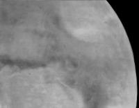
Mariner 6 Mosaics.
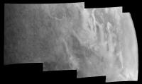
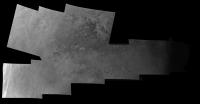
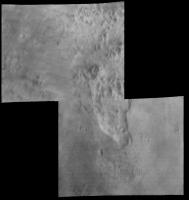
I have reprocessed the mosaics from Mariner-6. I reconstructed the frames based on both the analog and the digital transmissions of the image. The analog images were filtered to enhance the visibility of topography, wiping out brightness information. The digital images were in 7-bit form and only a fraction of the pixels were transmitted, but they contain proper brightness information. A set of images combining the two was constructed at the time, but there is definitely some loss of detail. Working in 16 bit, I can do a better job. I also worked to remove after-images. Another problem is that the wide angle camera that took these mosaics cycled through filters but did not take the images on top of each other for color combination. Rather, the filters were simply included to test the photographic properties for color studies on future missions (although Mariner-7 did some color work). As a result, I had to modify the mosaics so that the frames would cosmetically match. Far encounter (last two frames).
Mosaic 1
Mosaic 2 and 3. These overlapped. Also, there was a small gore between the two mosaics. I filled it in with Mariner 7 near encounter data.
Narrow angle. Narrow angle frames 6 and 14 happened to slightly overlap, allowing the one narrow angle mosaic to be made.
I am now working on Mariner 7 mosaics. There are more Mariner 7 images, and due to some issues with the digital versions of them, they are proving quite difficult. I hope to post them soon. I also hope to further clean up the Mariner 6 frames and mosaics. -------------------- |
||||
 |
 
|
||||
 |
|
Aug 5 2008, 04:51 AM
Post
#2
|
|
 Senior Member Group: Members Posts: 3419 Joined: 9-February 04 From: Minneapolis, MN, USA Member No.: 15 |
Most of what was named "chaotic terrain" ended up being large areas that seem to have had groundwater sapped out from under them. Most all of these landforms are at the heads of the catastrophic flood channels. It's consistent with large masses of groundwater being suddenly released (possibly by the breaking of ice dams) -- the lands that covered the huge aquifers collapsed, and the lands downstream of the massive water release were scored and flattened by the floods, with characteristic teardrop-shaped "islands" being carved by water passing to the sides of areographic high points.
So, yeah -- they're not "exotic chaos features," they're understandable and recognizable (if very large) collapse features. -the other Doug -------------------- The trouble ain't that there is too many fools, but that the lightning ain't distributed right. -Mark Twain
|
|
|
|
 tedstryk Mariner 6 and 7 Mosaics Aug 4 2008, 08:56 PM
 nprev Very nice indeed, Ted!!!
Makes me won... Aug 4 2008, 09:45 PM
nprev Very nice indeed, Ted!!!
Makes me won... Aug 4 2008, 09:45 PM
 tedstryk A lot of the terrain was referred to as "chao... Aug 5 2008, 04:18 AM tedstryk Some were from sapping, but other "chaotic... Aug 5 2008, 06:05 PM tedstryk Here are the first mosaics. There is no mosaic 2 ... Aug 8 2008, 07:16 PM Phil Stooke As usual, fantastic work, Ted. The Mariner 6 ... Aug 8 2008, 09:42 PM tedstryk I replaced it with a better 8-bit conversion. I a... Aug 8 2008, 09:54 PM PaulM QUOTE (Phil Stooke @ Aug 8 2008, 10:42 PM... Sep 19 2008, 08:30 PM Phil Stooke Sorry! I forgot.
Here is an excerpt from Ted... Sep 19 2008, 09:19 PM PaulM QUOTE (Phil Stooke @ Sep 19 2008, 10:19 P... Sep 19 2008, 09:29 PM elakdawalla Oh, my. That one went straight to the blog.
--Em... Sep 19 2008, 10:20 PM tedstryk Unfortunately, it is in one of the worst frames, b... Sep 19 2008, 10:49 PM tedstryk This isn't exactly a mosaic, but I have been w... Feb 14 2012, 01:58 AM vikingmars QUOTE (tedstryk @ Feb 14 2012, 02:58 AM) ... Feb 15 2012, 03:16 PM mcaplinger QUOTE (tedstryk @ Aug 4 2008, 01:56 PM) T... Sep 4 2013, 03:33 AM tedstryk For the color approach sequence, there was no anal... Sep 4 2013, 09:42 AM mcaplinger QUOTE (tedstryk @ Sep 4 2013, 02:42 AM) F... Sep 4 2013, 04:11 PM Brian Swift While looking into Mariner 6/7 image processing to... Aug 26 2022, 11:50 PM Phil Stooke This is a good opportunity to post this - the sum ... Sep 9 2022, 10:55 PM Antdoghalo This is neat! Do you by chance have a cylindri... Sep 11 2022, 03:42 AM Phil Stooke I don't have a version with the near encounter... Sep 11 2022, 07:10 AM Antdoghalo QUOTE (Phil Stooke @ Sep 11 2022, 02:10 A... Jan 8 2023, 03:38 PM Antdoghalo Do you plan to make a combination of Mariner 4, 6 ... Oct 22 2022, 01:53 PM Phil Stooke The composite was made in the azimuthal projection... Oct 23 2022, 07:08 AM Phil Stooke I will find those flies.
Phil Jan 9 2023, 05:28 PM Antdoghalo Did you ever find the gridless near and far encoun... Jan 31 2023, 10:51 PM Phil Stooke Yes. Here they are. Mariners 4, 6 and 7 combined... Feb 3 2023, 06:19 PM vikingmars QUOTE (Phil Stooke @ Feb 3 2023, 07:19 PM... Feb 4 2023, 06:55 AM Antdoghalo I managed to reproject these and with slight touch... Feb 9 2023, 02:48 PM Phil Stooke Very nice!
On my originals and on this projec... Feb 10 2023, 12:00 AM Antdoghalo For the far encounter, I noticed you used only Mar... Feb 10 2023, 11:01 PM
tedstryk A lot of the terrain was referred to as "chao... Aug 5 2008, 04:18 AM tedstryk Some were from sapping, but other "chaotic... Aug 5 2008, 06:05 PM tedstryk Here are the first mosaics. There is no mosaic 2 ... Aug 8 2008, 07:16 PM Phil Stooke As usual, fantastic work, Ted. The Mariner 6 ... Aug 8 2008, 09:42 PM tedstryk I replaced it with a better 8-bit conversion. I a... Aug 8 2008, 09:54 PM PaulM QUOTE (Phil Stooke @ Aug 8 2008, 10:42 PM... Sep 19 2008, 08:30 PM Phil Stooke Sorry! I forgot.
Here is an excerpt from Ted... Sep 19 2008, 09:19 PM PaulM QUOTE (Phil Stooke @ Sep 19 2008, 10:19 P... Sep 19 2008, 09:29 PM elakdawalla Oh, my. That one went straight to the blog.
--Em... Sep 19 2008, 10:20 PM tedstryk Unfortunately, it is in one of the worst frames, b... Sep 19 2008, 10:49 PM tedstryk This isn't exactly a mosaic, but I have been w... Feb 14 2012, 01:58 AM vikingmars QUOTE (tedstryk @ Feb 14 2012, 02:58 AM) ... Feb 15 2012, 03:16 PM mcaplinger QUOTE (tedstryk @ Aug 4 2008, 01:56 PM) T... Sep 4 2013, 03:33 AM tedstryk For the color approach sequence, there was no anal... Sep 4 2013, 09:42 AM mcaplinger QUOTE (tedstryk @ Sep 4 2013, 02:42 AM) F... Sep 4 2013, 04:11 PM Brian Swift While looking into Mariner 6/7 image processing to... Aug 26 2022, 11:50 PM Phil Stooke This is a good opportunity to post this - the sum ... Sep 9 2022, 10:55 PM Antdoghalo This is neat! Do you by chance have a cylindri... Sep 11 2022, 03:42 AM Phil Stooke I don't have a version with the near encounter... Sep 11 2022, 07:10 AM Antdoghalo QUOTE (Phil Stooke @ Sep 11 2022, 02:10 A... Jan 8 2023, 03:38 PM Antdoghalo Do you plan to make a combination of Mariner 4, 6 ... Oct 22 2022, 01:53 PM Phil Stooke The composite was made in the azimuthal projection... Oct 23 2022, 07:08 AM Phil Stooke I will find those flies.
Phil Jan 9 2023, 05:28 PM Antdoghalo Did you ever find the gridless near and far encoun... Jan 31 2023, 10:51 PM Phil Stooke Yes. Here they are. Mariners 4, 6 and 7 combined... Feb 3 2023, 06:19 PM vikingmars QUOTE (Phil Stooke @ Feb 3 2023, 07:19 PM... Feb 4 2023, 06:55 AM Antdoghalo I managed to reproject these and with slight touch... Feb 9 2023, 02:48 PM Phil Stooke Very nice!
On my originals and on this projec... Feb 10 2023, 12:00 AM Antdoghalo For the far encounter, I noticed you used only Mar... Feb 10 2023, 11:01 PM |

|
Lo-Fi Version | Time is now: 23rd September 2024 - 01:46 PM |
|
RULES AND GUIDELINES Please read the Forum Rules and Guidelines before posting. IMAGE COPYRIGHT |
OPINIONS AND MODERATION Opinions expressed on UnmannedSpaceflight.com are those of the individual posters and do not necessarily reflect the opinions of UnmannedSpaceflight.com or The Planetary Society. The all-volunteer UnmannedSpaceflight.com moderation team is wholly independent of The Planetary Society. The Planetary Society has no influence over decisions made by the UnmannedSpaceflight.com moderators. |
SUPPORT THE FORUM Unmannedspaceflight.com is funded by the Planetary Society. Please consider supporting our work and many other projects by donating to the Society or becoming a member. |
|