Storms from Orbit |

Storms from Orbit |
 Sep 7 2008, 03:37 AM Sep 7 2008, 03:37 AM
Post
#1
|
||
 Senior Member  Group: Moderator Posts: 2785 Joined: 10-November 06 From: Pasadena, CA Member No.: 1345 |
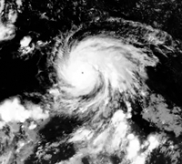
This is a project I've been working on for a while....it is an aligned sequence of images of Hurricane Dean in the Atlantic/Caribbean basin from 0000 UTC August 18, 2007 to 0900 UTC August 21, 2007. During this time, Hurricane Dean was a strong Category 4/5 storm.
(Click to view the animated GIF) The images are aligned such that the outer rain bands have minimal displacement (semi-rotating coordinate frame). The black dot in the middle of the image is the eye of the hurricane. Image source: EUMETSTAT NERC Satellite Receiving Station, Dundee University, Scotland; http://www.sat.dundee.ac.uk/ -Mike [EDIT: These were taken using IR (Channel 4) from the GOES12 satellite. The images have been contrast-enhanced to bring out detail in the cloud structure.] -------------------- Some higher resolution images available at my photostream: http://www.flickr.com/photos/31678681@N07/
|
|
 |
 
|
|

 Juramike Spin-O-Vision of the core of Hurricane Dean:
(C... Sep 8 2008, 04:25 AM Juramike Spin-O-Vision of the outer fringes of Hurricane De... Sep 14 2008, 07:47 PM Juramike Animated zoom of the lower left section of the seq... Sep 14 2008, 07:53 PM Juramike A stunning image from the ISS taken of Hurricane I... Sep 14 2008, 07:58 PM Juramike Aquavision image of Tropical Storm Erika in her fi... Sep 7 2009, 07:07 PM Juramike Here is a time-lapse 4 minute video prepared by NO... Oct 21 2009, 01:11 PM
Juramike Spin-O-Vision of the core of Hurricane Dean:
(C... Sep 8 2008, 04:25 AM Juramike Spin-O-Vision of the outer fringes of Hurricane De... Sep 14 2008, 07:47 PM Juramike Animated zoom of the lower left section of the seq... Sep 14 2008, 07:53 PM Juramike A stunning image from the ISS taken of Hurricane I... Sep 14 2008, 07:58 PM Juramike Aquavision image of Tropical Storm Erika in her fi... Sep 7 2009, 07:07 PM Juramike Here is a time-lapse 4 minute video prepared by NO... Oct 21 2009, 01:11 PM
 ups QUOTE (Juramike @ Oct 21 2009, 01:11 PM) ... Oct 25 2009, 03:38 PM ups Just stumbled on this old thread -- here are some ... Oct 24 2009, 05:01 PM Josh Stephens The pictures are cool! Storms are stunning to ... Oct 23 2010, 03:26 AM stevesliva Beautiful [composite?] image from EUMETSAT of Typh... Nov 8 2013, 05:55 PM
  |

|
Lo-Fi Version | Time is now: 22nd September 2024 - 11:04 AM |
|
RULES AND GUIDELINES Please read the Forum Rules and Guidelines before posting. IMAGE COPYRIGHT |
OPINIONS AND MODERATION Opinions expressed on UnmannedSpaceflight.com are those of the individual posters and do not necessarily reflect the opinions of UnmannedSpaceflight.com or The Planetary Society. The all-volunteer UnmannedSpaceflight.com moderation team is wholly independent of The Planetary Society. The Planetary Society has no influence over decisions made by the UnmannedSpaceflight.com moderators. |
SUPPORT THE FORUM Unmannedspaceflight.com is funded by the Planetary Society. Please consider supporting our work and many other projects by donating to the Society or becoming a member. |
|