Endeavour Crater, And again shall we conquer the Remoteness |

Endeavour Crater, And again shall we conquer the Remoteness |
 Sep 29 2008, 03:13 PM Sep 29 2008, 03:13 PM
Post
#1
|
||
 Special Cookie  Group: Members Posts: 2168 Joined: 6-April 05 From: Sintra | Portugal Member No.: 228 |
Opportunity is getting ready to embark on her most extraordinary journey, a true rover epic.
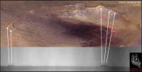
As information regarding how to win the distance are being collected here, and the emotional last views from Victoria Crater are being discussed here, I thought about creating a new thread that will surely become an obligatory stop as the tall peaks and other features of Endeavour start to rise in the horizon. Here we will be able to discuss the location of features seen from the distance, references that will help us understanding better what we are seing and that will, fortunately, feed our spirit across the long sail across the Meridiani sandwaves. Ultreya!  I give it a kick with this navcam image, comparing it with Astro0's original (beautiful...) image:
I'm sure James Canvin will correct me...  EDITED: I can't resist...I tried! I honestly tried, but it is stronger than me...so many features ahead and not a single name?!  Seriously, at Victoria we had features named after places visited by the vessel, and now for Endeavour? Assuming that Oppy will succeed on her quest will the mission keep the same policy, of naming places after Endeavour's tour? If so, there may be some names in common with Victoria...  While we are ready to leave the port once more I remembered that we could start naming, internally, (in order to have catchier landmark references... ) these features, as they loom in the horizon, after the ship's crew.We could follow the order presented here. Let me just edit the image up there...
-------------------- "Ride, boldly ride," The shade replied, "If you seek for Eldorado!"
Edgar Alan Poe |
|
 |
 
|
|
 |
|
Sep 30 2008, 10:45 AM
Post
#2
|
|
|
Senior Member Group: Members Posts: 2922 Joined: 14-February 06 From: Very close to the Pyrénées Mountains (France) Member No.: 682 |
For quite a while, we're going to extract as much informations of Endeavour's rim as possible from a few pixels.
I wonder if pictures (from Spirit) of the rim of Gusev can be used to better help assuming what is real and what it's not. I'm sure we can find, in the data base, pictures of Gusev's rim at approximately the same distance, such pictures from the plain could be compared to pictures from the top of Husband's hill. I'm here assessing that the quality from the top is better than from the plain. Later into the traverse we'll be able to compare some Victoria's features (at least the Beacon I guess) as seen from a distance to what we realy know. Just a thought. -------------------- |
|
|
|
 ustrax Endeavour Crater Sep 29 2008, 03:13 PM
 jamescanvin QUOTE (ustrax @ Sep 29 2008, 04:13 PM) I... Sep 29 2008, 04:05 PM
 climber QUOTE (jamescanvin @ Sep 29 2008, 06:05 P... Sep 29 2008, 04:30 PM
 ustrax QUOTE (jamescanvin @ Sep 29 2008, 05:05 P... Sep 29 2008, 04:44 PM ilbasso Looking back at this thread from two years ago, I ... Sep 29 2008, 04:24 PM charborob We should be on the lookout also for the ridge on ... Sep 29 2008, 04:34 PM fredk QUOTE (ustrax @ Sep 29 2008, 04:13 PM) I ... Sep 29 2008, 05:17 PM Pertinax QUOTE (fredk @ Sep 29 2008, 01:17 PM) Tha... Sep 29 2008, 07:34 PM jamescanvin Anyone remember those 'Inverse polar' imag... Sep 29 2008, 06:33 PM ustrax James...
I like that...a lot!
It looks... Sep 29 2008, 06:48 PM climber So James Cook () isn't Rui's Cook, correct... Sep 29 2008, 07:53 PM climber I'm pretty sure I already said that somewhere ... Sep 29 2008, 08:06 PM Shaka Is it possible that the correct term was not ... Sep 29 2008, 09:14 PM jamescanvin QUOTE (ustrax @ Sep 29 2008, 07:48 PM) It... Sep 29 2008, 09:14 PM Bobby Does anyone have any idea how deep Endeavour Crate... Sep 29 2008, 10:52 PM Astro0 Not sure if this alternate view of Endeavour crate... Sep 29 2008, 11:14 PM Phil Stooke That's really nice. You can see how the Meridi... Sep 30 2008, 12:34 AM ustrax Really, really nice!
Looking at this old i... Sep 30 2008, 06:38 AM jamescanvin QUOTE (ustrax @ Sep 30 2008, 07:38 AM) Ja... Sep 30 2008, 10:31 AM climber QUOTE (jamescanvin @ Sep 30 2008, 12:31 P... Sep 30 2008, 10:49 AM ustrax James is my hero!...
A perfect match! ... Sep 30 2008, 11:14 AM jamescanvin QUOTE (ustrax @ Sep 30 2008, 12:14 PM) A ... Sep 30 2008, 12:11 PM ustrax QUOTE (jamescanvin @ Sep 30 2008, 01:11 P... Sep 30 2008, 02:19 PM Ant103 Astro0 : I'm curious to know how do you obtain... Sep 30 2008, 08:56 AM djellison It's from the HRSCView website - from MEX HRSC... Sep 30 2008, 09:12 AM Astro0 Ant103 - "I'm curious to know how do you ... Sep 30 2008, 12:24 PM djellison I've tried using that HRSC DEM for animation -... Sep 30 2008, 12:45 PM rogelio Hypothetical question (and pardon if this is isnt... Sep 30 2008, 02:43 PM djellison QUOTE (rogelio @ Sep 30 2008, 03:43 PM) H... Sep 30 2008, 03:06 PM Stu Ustrax,
I have nothing to contribute to this amaz... Sep 30 2008, 03:15 PM dvandorn QUOTE (Stu @ Sep 30 2008, 10:15 AM) ...ha... Sep 30 2008, 04:01 PM ustrax QUOTE I have nothing to contribute to this amazing... Sep 30 2008, 05:08 PM Ant103 QUOTE (djellison @ Sep 30 2008, 02:45 PM)... Sep 30 2008, 03:20 PM djellison Why do you need to ask me if you can try? The dat... Sep 30 2008, 03:43 PM Ant103 Okay Doug, I misunderstand. Sorry. Sep 30 2008, 04:24 PM Phil Stooke Wow, Other Doug, I didn't think anybody would ... Sep 30 2008, 04:34 PM marswiggle Fortunately I long ago downloaded and saved some i... Sep 30 2008, 05:21 PM ustrax QUOTE (marswiggle @ Sep 30 2008, 06:21 PM... Sep 30 2008, 06:49 PM charborob Using these images, would it be possible by triang... Sep 30 2008, 06:23 PM ilbasso In spite of the dusty, cold weather,
We're off... Sep 30 2008, 07:11 PM marswiggle QUOTE (ustrax @ Sep 30 2008, 06:49 PM) ma... Sep 30 2008, 07:45 PM marswiggle
These include the long baseline images I used (... Sep 30 2008, 07:55 PM Tesheiner One of the peaks can be clearly seen on the today... Sep 30 2008, 09:30 PM climber QUOTE (Tesheiner @ Sep 30 2008, 11:30 PM)... Sep 30 2008, 09:49 PM ustrax Tesheiner...don't you ever sleep?!
I'v... Oct 1 2008, 12:13 AM Phil Stooke Rogelio asked if Opportunity might have gone somew... Oct 1 2008, 12:53 AM ElkGroveDan I would add to the "if we knew" possibil... Oct 1 2008, 03:42 AM Stu One for our Cheerleader...
Oct 1 2008, 05:48 AM Stu I know Oppy will never reach it, but I still think... Oct 1 2008, 01:28 PM Tesheiner QUOTE (Stu @ Oct 1 2008, 03:28 PM) I know... Oct 1 2008, 02:22 PM Stu QUOTE (Tesheiner @ Oct 1 2008, 03:22 PM) ... Oct 1 2008, 03:35 PM climber QUOTE (Stu @ Oct 1 2008, 03:28 PM) I know... Oct 1 2008, 04:53 PM ElkGroveDan How about...Medusa. Oct 1 2008, 01:31 PM TheChemist QUOTE (ElkGroveDan @ Oct 1 2008, 04:31 PM... Oct 1 2008, 01:41 PM climber QUOTE (ElkGroveDan @ Oct 1 2008, 03:31 PM... Oct 1 2008, 04:59 PM djellison Medusa, whos head Persus gave to......ATHENA (our ... Oct 1 2008, 01:44 PM ustrax Is that a challenge?...Accepted!
Jiigurru (... Oct 1 2008, 02:09 PM mhoward QUOTE (djellison @ Oct 1 2008, 06:44 AM) ... Oct 1 2008, 05:03 PM eoincampbell Was Ithaca dropped in favor of Endeavor for Big Cr... Oct 2 2008, 04:25 AM Astro0 Ithaca is just what we've been calling the big... Oct 2 2008, 06:04 AM Astro0 Stu, I hope you don't mind, but your latest pr... Oct 2 2008, 07:59 AM Stu QUOTE (Astro0 @ Oct 2 2008, 08:59 AM) Stu... Oct 2 2008, 01:18 PM climber What will we be without these two ... (not talki... Oct 2 2008, 08:27 AM charborob Here are some very rough straight-line distance es... Oct 2 2008, 04:33 PM ustrax Astro0, the image in that second poster is simply ... Oct 2 2008, 07:54 PM Stu Rui... want to share these with you...
Exultation... Oct 2 2008, 08:42 PM ustrax Stu, impossible to imagine this mission without it... Oct 3 2008, 07:17 AM Ant103 This become a poetry room
Astro0 : great posters... Oct 3 2008, 07:44 AM Stu That's really nice, Ant... love the way you... Oct 3 2008, 08:05 AM Tesheiner QUOTE (Stu @ Oct 3 2008, 10:05 AM) I know... Oct 3 2008, 08:25 AM ustrax James, still sleeping?
There's work to be done... Oct 3 2008, 09:48 AM RoverDriver QUOTE (Stu @ Oct 3 2008, 12:05 AM) ...
On... Oct 3 2008, 05:21 PM ustrax Paolo, I know that you are on the engineering side... Oct 3 2008, 07:01 PM climber QUOTE (ustrax @ Oct 3 2008, 09:01 PM) Pao... Oct 3 2008, 07:18 PM RoverDriver QUOTE (ustrax @ Oct 3 2008, 11:01 AM) Pao... Oct 3 2008, 07:56 PM ustrax I can understand Paolo, I really can, but if you c... Oct 3 2008, 08:10 PM Greg Hullender QUOTE (Stu @ Oct 3 2008, 12:05 AM) On the... Oct 4 2008, 01:07 AM ustrax QUOTE (Greg Hullender @ Oct 4 2008, 02:07... Oct 4 2008, 06:08 PM ustrax Just received an e-mail...looks like Jim Bell jgot... Oct 4 2008, 06:51 PM TheChemist QUOTE (ustrax @ Oct 4 2008, 09:08 PM) The... Oct 4 2008, 07:03 PM Greg Hullender QUOTE (ustrax @ Oct 4 2008, 11:08 AM) . .... Oct 4 2008, 10:00 PM djellison QUOTE (Greg Hullender @ Oct 4 2008, 02:07... Oct 4 2008, 09:29 PM Tesheiner Rui, that image is looking north so not related to... Oct 3 2008, 10:12 AM ustrax QUOTE (Tesheiner @ Oct 3 2008, 11:12 AM) ... Oct 3 2008, 10:20 AM climber Stu,
You're so right. Just look at the posts ... Oct 3 2008, 10:55 AM ustrax QUOTE (climber @ Oct 3 2008, 11:55 AM) Th... Oct 3 2008, 11:29 AM Phil Stooke Rui's hill is the big drift fringing Duck Bay.... Oct 3 2008, 11:55 AM Tman Could/should be the rim of the Duck Bay. Oct 3 2008, 11:57 AM Bobby Hi Ustrax
Where is Pando??? No reply from him S... Oct 3 2008, 07:10 PM climber QUOTE (Bobby @ Oct 3 2008, 09:10 PM) Hi U... Oct 3 2008, 07:20 PM Bobby Thanks Climber
Yes I did miss that post and thank... Oct 3 2008, 07:29 PM TheChemist In view of the publicity Kavafis got in UMSF, it i... Oct 3 2008, 11:45 PM Shaka Made weak by time and fate, but strong in will
To ... Oct 4 2008, 10:12 PM ustrax "...Come, my friends,
'Tis not too late t... Oct 4 2008, 11:27 PM CosmicRocker /me wipes a tear from his eye and provides hugs fo... Oct 5 2008, 06:50 AM Shaka QUOTE (CosmicRocker @ Oct 4 2008, 08:50 P... Oct 5 2008, 07:46 AM ustrax QUOTE (CosmicRocker @ Oct 5 2008, 07:50 A... Oct 5 2008, 11:59 AM BrianL QUOTE (CosmicRocker @ Oct 5 2008, 01:50 A... Oct 5 2008, 02:52 PM CosmicRocker We probably should not go there. I am crying ag... Oct 5 2008, 07:55 AM
ustrax QUOTE (jamescanvin @ Sep 29 2008, 05:05 P... Sep 29 2008, 04:44 PM ilbasso Looking back at this thread from two years ago, I ... Sep 29 2008, 04:24 PM charborob We should be on the lookout also for the ridge on ... Sep 29 2008, 04:34 PM fredk QUOTE (ustrax @ Sep 29 2008, 04:13 PM) I ... Sep 29 2008, 05:17 PM Pertinax QUOTE (fredk @ Sep 29 2008, 01:17 PM) Tha... Sep 29 2008, 07:34 PM jamescanvin Anyone remember those 'Inverse polar' imag... Sep 29 2008, 06:33 PM ustrax James...
I like that...a lot!
It looks... Sep 29 2008, 06:48 PM climber So James Cook () isn't Rui's Cook, correct... Sep 29 2008, 07:53 PM climber I'm pretty sure I already said that somewhere ... Sep 29 2008, 08:06 PM Shaka Is it possible that the correct term was not ... Sep 29 2008, 09:14 PM jamescanvin QUOTE (ustrax @ Sep 29 2008, 07:48 PM) It... Sep 29 2008, 09:14 PM Bobby Does anyone have any idea how deep Endeavour Crate... Sep 29 2008, 10:52 PM Astro0 Not sure if this alternate view of Endeavour crate... Sep 29 2008, 11:14 PM Phil Stooke That's really nice. You can see how the Meridi... Sep 30 2008, 12:34 AM ustrax Really, really nice!
Looking at this old i... Sep 30 2008, 06:38 AM jamescanvin QUOTE (ustrax @ Sep 30 2008, 07:38 AM) Ja... Sep 30 2008, 10:31 AM climber QUOTE (jamescanvin @ Sep 30 2008, 12:31 P... Sep 30 2008, 10:49 AM ustrax James is my hero!...
A perfect match! ... Sep 30 2008, 11:14 AM jamescanvin QUOTE (ustrax @ Sep 30 2008, 12:14 PM) A ... Sep 30 2008, 12:11 PM ustrax QUOTE (jamescanvin @ Sep 30 2008, 01:11 P... Sep 30 2008, 02:19 PM Ant103 Astro0 : I'm curious to know how do you obtain... Sep 30 2008, 08:56 AM djellison It's from the HRSCView website - from MEX HRSC... Sep 30 2008, 09:12 AM Astro0 Ant103 - "I'm curious to know how do you ... Sep 30 2008, 12:24 PM djellison I've tried using that HRSC DEM for animation -... Sep 30 2008, 12:45 PM rogelio Hypothetical question (and pardon if this is isnt... Sep 30 2008, 02:43 PM djellison QUOTE (rogelio @ Sep 30 2008, 03:43 PM) H... Sep 30 2008, 03:06 PM Stu Ustrax,
I have nothing to contribute to this amaz... Sep 30 2008, 03:15 PM dvandorn QUOTE (Stu @ Sep 30 2008, 10:15 AM) ...ha... Sep 30 2008, 04:01 PM ustrax QUOTE I have nothing to contribute to this amazing... Sep 30 2008, 05:08 PM Ant103 QUOTE (djellison @ Sep 30 2008, 02:45 PM)... Sep 30 2008, 03:20 PM djellison Why do you need to ask me if you can try? The dat... Sep 30 2008, 03:43 PM Ant103 Okay Doug, I misunderstand. Sorry. Sep 30 2008, 04:24 PM Phil Stooke Wow, Other Doug, I didn't think anybody would ... Sep 30 2008, 04:34 PM marswiggle Fortunately I long ago downloaded and saved some i... Sep 30 2008, 05:21 PM ustrax QUOTE (marswiggle @ Sep 30 2008, 06:21 PM... Sep 30 2008, 06:49 PM charborob Using these images, would it be possible by triang... Sep 30 2008, 06:23 PM ilbasso In spite of the dusty, cold weather,
We're off... Sep 30 2008, 07:11 PM marswiggle QUOTE (ustrax @ Sep 30 2008, 06:49 PM) ma... Sep 30 2008, 07:45 PM marswiggle
These include the long baseline images I used (... Sep 30 2008, 07:55 PM Tesheiner One of the peaks can be clearly seen on the today... Sep 30 2008, 09:30 PM climber QUOTE (Tesheiner @ Sep 30 2008, 11:30 PM)... Sep 30 2008, 09:49 PM ustrax Tesheiner...don't you ever sleep?!
I'v... Oct 1 2008, 12:13 AM Phil Stooke Rogelio asked if Opportunity might have gone somew... Oct 1 2008, 12:53 AM ElkGroveDan I would add to the "if we knew" possibil... Oct 1 2008, 03:42 AM Stu One for our Cheerleader...
Oct 1 2008, 05:48 AM Stu I know Oppy will never reach it, but I still think... Oct 1 2008, 01:28 PM Tesheiner QUOTE (Stu @ Oct 1 2008, 03:28 PM) I know... Oct 1 2008, 02:22 PM Stu QUOTE (Tesheiner @ Oct 1 2008, 03:22 PM) ... Oct 1 2008, 03:35 PM climber QUOTE (Stu @ Oct 1 2008, 03:28 PM) I know... Oct 1 2008, 04:53 PM ElkGroveDan How about...Medusa. Oct 1 2008, 01:31 PM TheChemist QUOTE (ElkGroveDan @ Oct 1 2008, 04:31 PM... Oct 1 2008, 01:41 PM climber QUOTE (ElkGroveDan @ Oct 1 2008, 03:31 PM... Oct 1 2008, 04:59 PM djellison Medusa, whos head Persus gave to......ATHENA (our ... Oct 1 2008, 01:44 PM ustrax Is that a challenge?...Accepted!
Jiigurru (... Oct 1 2008, 02:09 PM mhoward QUOTE (djellison @ Oct 1 2008, 06:44 AM) ... Oct 1 2008, 05:03 PM eoincampbell Was Ithaca dropped in favor of Endeavor for Big Cr... Oct 2 2008, 04:25 AM Astro0 Ithaca is just what we've been calling the big... Oct 2 2008, 06:04 AM Astro0 Stu, I hope you don't mind, but your latest pr... Oct 2 2008, 07:59 AM Stu QUOTE (Astro0 @ Oct 2 2008, 08:59 AM) Stu... Oct 2 2008, 01:18 PM climber What will we be without these two ... (not talki... Oct 2 2008, 08:27 AM charborob Here are some very rough straight-line distance es... Oct 2 2008, 04:33 PM ustrax Astro0, the image in that second poster is simply ... Oct 2 2008, 07:54 PM Stu Rui... want to share these with you...
Exultation... Oct 2 2008, 08:42 PM ustrax Stu, impossible to imagine this mission without it... Oct 3 2008, 07:17 AM Ant103 This become a poetry room
Astro0 : great posters... Oct 3 2008, 07:44 AM Stu That's really nice, Ant... love the way you... Oct 3 2008, 08:05 AM Tesheiner QUOTE (Stu @ Oct 3 2008, 10:05 AM) I know... Oct 3 2008, 08:25 AM ustrax James, still sleeping?
There's work to be done... Oct 3 2008, 09:48 AM RoverDriver QUOTE (Stu @ Oct 3 2008, 12:05 AM) ...
On... Oct 3 2008, 05:21 PM ustrax Paolo, I know that you are on the engineering side... Oct 3 2008, 07:01 PM climber QUOTE (ustrax @ Oct 3 2008, 09:01 PM) Pao... Oct 3 2008, 07:18 PM RoverDriver QUOTE (ustrax @ Oct 3 2008, 11:01 AM) Pao... Oct 3 2008, 07:56 PM ustrax I can understand Paolo, I really can, but if you c... Oct 3 2008, 08:10 PM Greg Hullender QUOTE (Stu @ Oct 3 2008, 12:05 AM) On the... Oct 4 2008, 01:07 AM ustrax QUOTE (Greg Hullender @ Oct 4 2008, 02:07... Oct 4 2008, 06:08 PM ustrax Just received an e-mail...looks like Jim Bell jgot... Oct 4 2008, 06:51 PM TheChemist QUOTE (ustrax @ Oct 4 2008, 09:08 PM) The... Oct 4 2008, 07:03 PM Greg Hullender QUOTE (ustrax @ Oct 4 2008, 11:08 AM) . .... Oct 4 2008, 10:00 PM djellison QUOTE (Greg Hullender @ Oct 4 2008, 02:07... Oct 4 2008, 09:29 PM Tesheiner Rui, that image is looking north so not related to... Oct 3 2008, 10:12 AM ustrax QUOTE (Tesheiner @ Oct 3 2008, 11:12 AM) ... Oct 3 2008, 10:20 AM climber Stu,
You're so right. Just look at the posts ... Oct 3 2008, 10:55 AM ustrax QUOTE (climber @ Oct 3 2008, 11:55 AM) Th... Oct 3 2008, 11:29 AM Phil Stooke Rui's hill is the big drift fringing Duck Bay.... Oct 3 2008, 11:55 AM Tman Could/should be the rim of the Duck Bay. Oct 3 2008, 11:57 AM Bobby Hi Ustrax
Where is Pando??? No reply from him S... Oct 3 2008, 07:10 PM climber QUOTE (Bobby @ Oct 3 2008, 09:10 PM) Hi U... Oct 3 2008, 07:20 PM Bobby Thanks Climber
Yes I did miss that post and thank... Oct 3 2008, 07:29 PM TheChemist In view of the publicity Kavafis got in UMSF, it i... Oct 3 2008, 11:45 PM Shaka Made weak by time and fate, but strong in will
To ... Oct 4 2008, 10:12 PM ustrax "...Come, my friends,
'Tis not too late t... Oct 4 2008, 11:27 PM CosmicRocker /me wipes a tear from his eye and provides hugs fo... Oct 5 2008, 06:50 AM Shaka QUOTE (CosmicRocker @ Oct 4 2008, 08:50 P... Oct 5 2008, 07:46 AM ustrax QUOTE (CosmicRocker @ Oct 5 2008, 07:50 A... Oct 5 2008, 11:59 AM BrianL QUOTE (CosmicRocker @ Oct 5 2008, 01:50 A... Oct 5 2008, 02:52 PM CosmicRocker We probably should not go there. I am crying ag... Oct 5 2008, 07:55 AM |

|
Lo-Fi Version | Time is now: 27th September 2024 - 06:30 AM |
|
RULES AND GUIDELINES Please read the Forum Rules and Guidelines before posting. IMAGE COPYRIGHT |
OPINIONS AND MODERATION Opinions expressed on UnmannedSpaceflight.com are those of the individual posters and do not necessarily reflect the opinions of UnmannedSpaceflight.com or The Planetary Society. The all-volunteer UnmannedSpaceflight.com moderation team is wholly independent of The Planetary Society. The Planetary Society has no influence over decisions made by the UnmannedSpaceflight.com moderators. |
SUPPORT THE FORUM Unmannedspaceflight.com is funded by the Planetary Society. Please consider supporting our work and many other projects by donating to the Society or becoming a member. |
|