foldable map of Ida |

foldable map of Ida |
 Oct 27 2008, 12:57 PM Oct 27 2008, 12:57 PM
Post
#1
|
||
|
Member  Group: Members Posts: 140 Joined: 20-November 07 Member No.: 3967 |
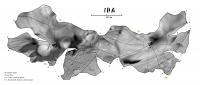
Here is a constant-scale natural boundary map of Ida that folds to a decent replica of the asteroid. Map edges are Ida's major ridges.[attachment=16299:Ida_MaxRidge_post.jpg]
[EDIT] Here it is again with the photomosaic properly credited; apologies to M. Nyrtsov for my oversight.
Attached thumbnail(s)
|
|
 |
 
|
|
 |
|
Nov 7 2008, 01:06 PM
Post
#2
|
|
 Member Group: Members Posts: 106 Joined: 26-September 05 Member No.: 508 |
I can convert the models to most popular formats.
Cutting the computer models in slices is an automatic process. I think it would be feasible to build such a model, the most difficult part would be cutting the slices from cardstock. If you have access to a laser cutter you will only have to glue them, using guide holes that I can add. |
|
|
|
 chuckclark foldable map of Ida Oct 27 2008, 12:57 PM
 jumpjack QUOTE (chuckclark @ Oct 27 2008, 02:57 PM... Nov 6 2008, 08:24 AM
 dilo I tried with the aid of my son but result was very... Nov 6 2008, 03:07 PM chuckclark I've put it together twice -- I'll post a ... Nov 6 2008, 05:31 PM Phil Stooke Does my old friend Maxim Nyrtsov read this? Hi Ma... Nov 6 2008, 06:14 PM jumpjack It was difficult for me even to build a paper Eart... Nov 7 2008, 07:26 AM chuckclark jumpjack:
Here is a link Phobos Arts and Crafts th... Nov 7 2008, 02:16 PM jumpjack QUOTE (chuckclark @ Nov 7 2008, 04:16 PM)... Nov 10 2008, 08:12 AM Tayfun Öner I built the physical models that Chuck is using to... Nov 7 2008, 11:41 AM jumpjack QUOTE (Tayfun Öner @ Nov 7 2008, 01:41 PM... Nov 7 2008, 12:52 PM djellison What format are those models available in? Nov 7 2008, 12:13 PM jumpjack QUOTE (Tayfun Öner @ Nov 7 2008, 03:06 PM... Nov 7 2008, 01:20 PM chuckclark OK, I corralled a photographer, (S. Adkins) to tak... Nov 10 2008, 01:33 PM Tayfun Öner Chuck the comparison photo is really impressive.
... Nov 10 2008, 03:13 PM jumpjack QUOTE (Tayfun Öner @ Nov 10 2008, 05:13 P... Nov 10 2008, 06:52 PM chuckclark Thanks, Tayfun. Like I say, the view from the oth... Nov 10 2008, 08:42 PM Tayfun Öner By hand I presume you mean manually, no I will mak... Nov 10 2008, 08:43 PM chuckclark this may surprise you but I don't have much fa... Nov 10 2008, 08:46 PM Tayfun Öner Here is a rendering from a similar angle. Nov 11 2008, 05:20 PM Tayfun Öner Here are the Phobos slices. As I don't know ho... Nov 11 2008, 06:00 PM chuckclark Well, so far so good. I downloaded and unzipped t... Nov 11 2008, 08:14 PM chuckclark QUOTE (Tayfun Öner @ Nov 11 2008, 01:00 P... Nov 15 2008, 06:54 PM chuckclark Okay, so borrowing a little from both systems, her... Nov 15 2008, 07:17 PM Tayfun Öner Chuck, that is brilliant. Here are your cuts both ... Nov 15 2008, 07:58 PM djellison GENIUS Nov 15 2008, 09:26 PM chuckclark QUOTE (djellison @ Nov 15 2008, 04:26 PM)... Nov 17 2008, 02:01 PM Phil Stooke Very interesting and entertaining stuff. I think ... Nov 17 2008, 04:10 PM Tayfun Öner Here are ribs for Eros. Nov 21 2008, 06:59 PM chuckclark QUOTE (Tayfun Öner @ Nov 21 2008, 01:59 P... Nov 21 2008, 10:02 PM Tayfun Öner Eros ribs updated, please note that north is up fo... Nov 22 2008, 10:56 AM jumpjack I just discovered that Google Sketchup can easily ... Dec 29 2008, 10:00 PM paxdan Here is a link to SliceModeler http://blog.makezin... Jan 6 2009, 06:08 PM jumpjack QUOTE (paxdan @ Jan 6 2009, 07:08 PM) Her... Jan 6 2009, 06:58 PM
dilo I tried with the aid of my son but result was very... Nov 6 2008, 03:07 PM chuckclark I've put it together twice -- I'll post a ... Nov 6 2008, 05:31 PM Phil Stooke Does my old friend Maxim Nyrtsov read this? Hi Ma... Nov 6 2008, 06:14 PM jumpjack It was difficult for me even to build a paper Eart... Nov 7 2008, 07:26 AM chuckclark jumpjack:
Here is a link Phobos Arts and Crafts th... Nov 7 2008, 02:16 PM jumpjack QUOTE (chuckclark @ Nov 7 2008, 04:16 PM)... Nov 10 2008, 08:12 AM Tayfun Öner I built the physical models that Chuck is using to... Nov 7 2008, 11:41 AM jumpjack QUOTE (Tayfun Öner @ Nov 7 2008, 01:41 PM... Nov 7 2008, 12:52 PM djellison What format are those models available in? Nov 7 2008, 12:13 PM jumpjack QUOTE (Tayfun Öner @ Nov 7 2008, 03:06 PM... Nov 7 2008, 01:20 PM chuckclark OK, I corralled a photographer, (S. Adkins) to tak... Nov 10 2008, 01:33 PM Tayfun Öner Chuck the comparison photo is really impressive.
... Nov 10 2008, 03:13 PM jumpjack QUOTE (Tayfun Öner @ Nov 10 2008, 05:13 P... Nov 10 2008, 06:52 PM chuckclark Thanks, Tayfun. Like I say, the view from the oth... Nov 10 2008, 08:42 PM Tayfun Öner By hand I presume you mean manually, no I will mak... Nov 10 2008, 08:43 PM chuckclark this may surprise you but I don't have much fa... Nov 10 2008, 08:46 PM Tayfun Öner Here is a rendering from a similar angle. Nov 11 2008, 05:20 PM Tayfun Öner Here are the Phobos slices. As I don't know ho... Nov 11 2008, 06:00 PM chuckclark Well, so far so good. I downloaded and unzipped t... Nov 11 2008, 08:14 PM chuckclark QUOTE (Tayfun Öner @ Nov 11 2008, 01:00 P... Nov 15 2008, 06:54 PM chuckclark Okay, so borrowing a little from both systems, her... Nov 15 2008, 07:17 PM Tayfun Öner Chuck, that is brilliant. Here are your cuts both ... Nov 15 2008, 07:58 PM djellison GENIUS Nov 15 2008, 09:26 PM chuckclark QUOTE (djellison @ Nov 15 2008, 04:26 PM)... Nov 17 2008, 02:01 PM Phil Stooke Very interesting and entertaining stuff. I think ... Nov 17 2008, 04:10 PM Tayfun Öner Here are ribs for Eros. Nov 21 2008, 06:59 PM chuckclark QUOTE (Tayfun Öner @ Nov 21 2008, 01:59 P... Nov 21 2008, 10:02 PM Tayfun Öner Eros ribs updated, please note that north is up fo... Nov 22 2008, 10:56 AM jumpjack I just discovered that Google Sketchup can easily ... Dec 29 2008, 10:00 PM paxdan Here is a link to SliceModeler http://blog.makezin... Jan 6 2009, 06:08 PM jumpjack QUOTE (paxdan @ Jan 6 2009, 07:08 PM) Her... Jan 6 2009, 06:58 PM |

|
Lo-Fi Version | Time is now: 23rd September 2024 - 06:44 PM |
|
RULES AND GUIDELINES Please read the Forum Rules and Guidelines before posting. IMAGE COPYRIGHT |
OPINIONS AND MODERATION Opinions expressed on UnmannedSpaceflight.com are those of the individual posters and do not necessarily reflect the opinions of UnmannedSpaceflight.com or The Planetary Society. The all-volunteer UnmannedSpaceflight.com moderation team is wholly independent of The Planetary Society. The Planetary Society has no influence over decisions made by the UnmannedSpaceflight.com moderators. |
SUPPORT THE FORUM Unmannedspaceflight.com is funded by the Planetary Society. Please consider supporting our work and many other projects by donating to the Society or becoming a member. |
|