Opportunity Route Map |

Opportunity Route Map |
 Feb 11 2005, 08:11 AM Feb 11 2005, 08:11 AM
Post
#1
|
||
 The Insider  Group: Members Posts: 669 Joined: 3-May 04 Member No.: 73 |
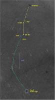
Here is an updated map of the road to Vostok.
Attached thumbnail(s)
|
|
 |
 
|
|
 |
|
Nov 10 2008, 07:07 PM
Post
#2
|
|
|
Member Group: Members Posts: 279 Joined: 19-August 07 Member No.: 3299 |
I am an occasional visitor to USMF. I got scared to see the long hop drives of Oppy. I am really interested in knowing exactly the route driving but I found the route map on the map to be mostly as a straight line except few intelligent zig zag in one day. I am puzzled on how Oppy has detected on the ahead obstacles in one day. I am supposing that the zig zag driving was already planned...
 My wishlist for this map is to have an exact Oppy's trayectory among crest of dunes. 
|
|
|
|
 Pando Opportunity Route Map Feb 11 2005, 08:11 AM
 djellison 800m marks? Nahh - that would just be added nois... Nov 2 2008, 10:22 AM
 centsworth_II QUOTE (djellison @ Nov 2 2008, 05:22 AM) ... Nov 2 2008, 06:47 PM Tesheiner Map update for sol 1700.
Nov 5 2008, 01:17 PM Tesheiner Update for sol 1702.
Nov 7 2008, 04:14 PM dvandorn Is it possible to annotate in some manner the rout... Nov 8 2008, 06:05 AM Tesheiner Actually, the map has already such thing, in some ... Nov 8 2008, 07:44 AM dvandorn Oh, sure, I knew you were trying to give a basic o... Nov 8 2008, 07:58 PM Tesheiner Update for sol 1704.
Nov 9 2008, 10:52 AM Oersted Yes, Tesheiners wonderful maps are mainly a tool f... Nov 11 2008, 11:41 AM climber QUOTE (SpaceListener @ Nov 10 2008, 08:07... Nov 11 2008, 05:30 PM djellison Tesheiner already adds about as much info as we ca... Nov 11 2008, 03:08 PM Tesheiner > ... but that from today download
That's ... Nov 12 2008, 10:05 AM Oersted Thanks for the update Tesheiner! - We'll s... Nov 12 2008, 10:51 AM Tesheiner Map update for sol 1709.
Nov 14 2008, 10:17 PM Tesheiner ... and for sol 1710.
Nov 15 2008, 06:21 PM James Sorenson I know this is sort of a dumb question, but can an... Dec 16 2008, 08:01 AM djellison It could be
http://hirise.lpl.arizona.edu/TRA_0008... Dec 16 2008, 08:17 AM RoverDriver QUOTE (djellison @ Dec 16 2008, 12:17 AM)... Dec 16 2008, 04:35 PM Tesheiner I think it's time to post the whole map again.... Jan 16 2009, 10:11 PM Tesheiner Here's a crop of the map with the latest drive... Jan 20 2009, 11:12 AM ngunn half the scale? Jan 20 2009, 12:17 PM Tesheiner Exactly. I changed the map scale to 1m/pix.
I was ... Jan 20 2009, 02:43 PM Tesheiner Here's the rover's position as of sol 1776... Jan 22 2009, 09:46 AM Tesheiner Here's the route map now including another km ... Jan 26 2009, 09:09 PM Tesheiner Here's a snapshot around sol 1782 position.
Jan 28 2009, 08:33 PM charborob Opportunity is still moving generally S-W. Do you ... Jan 29 2009, 03:19 AM Tesheiner I hope so. See a discussion starting with fredk... Jan 29 2009, 07:00 AM Tesheiner Opportunity's updated position after sol 1784.... Jan 30 2009, 12:14 PM akuo Tesheiner, looks like that's the same map as 3... Jan 30 2009, 01:04 PM BrianL QUOTE (akuo @ Jan 30 2009, 07:04 AM) Tesh... Jan 30 2009, 01:37 PM jamescanvin Yes, looks like Oppy's off the bottom of that ... Jan 30 2009, 01:37 PM Tesheiner Oooops! Now corrected!
(It was posted at ... Jan 30 2009, 08:55 PM HughFromAlice QUOTE (Tesheiner @ Jan 31 2009, 06:25 AM)... Jan 30 2009, 10:37 PM Tesheiner Quick map update with the latest data from sol 178... Feb 2 2009, 11:30 AM algorimancer I've clearly been out of the loop for the past... Feb 2 2009, 06:33 PM Tesheiner I haven't seen any map with the projected path... Feb 6 2009, 08:06 PM Tesheiner The latest map as of sol 1793.
Feb 8 2009, 06:08 PM Tesheiner Just playing around...
Launch Google Earth, Selec... Feb 8 2009, 10:17 PM ElkGroveDan Brilliant! (can you do that from now on?) Feb 8 2009, 11:00 PM helvick I second that, it's an excellent addition to t... Feb 9 2009, 12:06 AM Floyd The smooth area immediately ahead looks to me like... Feb 9 2009, 01:28 AM BrianL QUOTE (Floyd @ Feb 8 2009, 07:28 PM) The ... Feb 9 2009, 01:31 AM Astro0 OMG!
TEsh, if you can keep doing that for t... Feb 9 2009, 05:11 AM Tesheiner Thanks, all. There'll be no problem to keep up... Feb 9 2009, 08:46 AM Stephen QUOTE (Tesheiner @ Feb 9 2009, 07:46 PM) ... Feb 9 2009, 09:42 AM ustrax QUOTE (Stephen @ Feb 9 2009, 09:42 AM) If... Feb 9 2009, 10:07 AM Tesheiner > If you do does this mean you won't be pos... Feb 9 2009, 01:23 PM Tesheiner A quick map update for sol 1795.
And the layer(s)... Feb 10 2009, 05:45 PM ustrax Tesheiner, from your map covering the whole distan... Feb 11 2009, 08:13 AM Tesheiner Here's a link (http://www.unmannedspaceflight.... Feb 11 2009, 10:00 AM ustrax Thanks Tesheiner! That was just what I was loo... Feb 11 2009, 11:06 AM Tesheiner Map update for sol 1797.
Feb 12 2009, 09:26 PM antoniseb Can someone please remind me what the scale of the... Feb 13 2009, 06:04 AM Tesheiner 100m. Feb 13 2009, 07:00 AM ElkGroveDan Wow, we're really moving now. Feb 13 2009, 03:56 PM Enceladus75 Fantastic progress is being made by Oppy at the mo... Feb 14 2009, 07:45 PM brellis Oppy's gotta be setting a 1 week distance reco... Feb 14 2009, 11:19 PM Tesheiner Not so fast. Today's drive was the shortest si... Feb 15 2009, 09:27 PM jamescanvin I thought it might help visualise our progress and... Feb 15 2009, 10:58 PM elakdawalla Great idea! One typo -- you credit someone na... Feb 15 2009, 11:08 PM jamescanvin So I did - fixed.
Thanks Emily. Feb 15 2009, 11:15 PM Greg Hullender Thanks, James. I was hoping someone would do that... Feb 16 2009, 05:18 AM Tesheiner Good idea James, specially the one with the ripple... Feb 16 2009, 06:59 AM Tesheiner Here we go with another map update: Sol 1803.
Feb 19 2009, 09:50 AM Tesheiner Sol1806: Another 60m to the odometer.
Feb 22 2009, 07:52 AM Dig Hello to all, although I read the forum for some t... Feb 23 2009, 10:34 AM djellison The one that works via Google is less accurate tha... Feb 23 2009, 11:03 AM Tesheiner Welcome to UMSF, Dig.
> Tesheiner, the layer o... Feb 23 2009, 11:42 AM Tesheiner I think it's time to post the "big pictur... Mar 1 2009, 08:59 PM MahFL When o when will we head SE ?
Does anyone know wha... Mar 2 2009, 06:43 PM centsworth_II QUOTE (MahFL @ Mar 2 2009, 01:43 PM) Does... Mar 2 2009, 08:07 PM Floyd Seems like someone (official or here at UMSF) sugg... Mar 2 2009, 10:23 PM MahFL Well they must have great faith that Oppy will be ... Mar 3 2009, 01:39 PM Tesheiner Map update corresponding to sol 1816. We might be ... Mar 5 2009, 06:09 PM Tesheiner Here's a quick update with information from so... Mar 6 2009, 12:56 PM remcook Nice long drive. Keep it up Oppy!
(edit: oops... Mar 6 2009, 01:19 PM Tesheiner Sol 1820.
Mar 8 2009, 08:43 PM Marsahod Why Oppy turned its way back? Mar 10 2009, 10:11 AM jamescanvin We don't know yet.
Discussion of this type sh... Mar 10 2009, 10:24 AM Tesheiner Update for sol 1824.
Mar 12 2009, 05:29 PM Tesheiner Small bump on sol 1825.
Added a new feature (Cook ... Mar 13 2009, 01:38 PM Tesheiner Wow, three weeks without posting any update here... Apr 8 2009, 09:26 AM Enceladus75 Hmmm. Oppy seems to be a long time at this one spo... Apr 8 2009, 07:21 PM Tesheiner I checked the attachment just to see if I posted t... Apr 8 2009, 07:54 PM Tesheiner Sol 1852.
Apr 10 2009, 11:03 AM Tesheiner Update after sol 1854, including names for the ... Apr 12 2009, 08:33 PM Tesheiner Update after driving during sol 1856.
Apr 14 2009, 02:25 PM Tesheiner Update after sol 1857.
Apr 15 2009, 02:20 PM Tesheiner A quick update after driving a few hours ago durin... Apr 17 2009, 10:12 AM Tesheiner Update after sol 1860.
Apr 18 2009, 01:54 PM ustrax Well...that's nice...
Looks like Oppy will t... Apr 18 2009, 05:55 PM Tesheiner Update after sol 1863.
Apr 21 2009, 02:13 PM Tesheiner Update after sol 1864.
Apr 22 2009, 04:26 PM Tesheiner Map update for sol 1867.
Apr 25 2009, 08:56 PM Tesheiner I guess it may be time to post the whole map again... Apr 28 2009, 04:26 PM Stu Great map, as usual, but they always leave me a bi... Apr 28 2009, 05:03 PM Tesheiner QUOTE (Stu @ Apr 28 2009, 07:03 PM) We... Apr 28 2009, 07:59 PM climber Can't get a hand on the big picture. As we... Apr 28 2009, 05:07 PM jamescanvin QUOTE (climber @ Apr 28 2009, 06:07 PM) I... Apr 28 2009, 05:35 PM
centsworth_II QUOTE (djellison @ Nov 2 2008, 05:22 AM) ... Nov 2 2008, 06:47 PM Tesheiner Map update for sol 1700.
Nov 5 2008, 01:17 PM Tesheiner Update for sol 1702.
Nov 7 2008, 04:14 PM dvandorn Is it possible to annotate in some manner the rout... Nov 8 2008, 06:05 AM Tesheiner Actually, the map has already such thing, in some ... Nov 8 2008, 07:44 AM dvandorn Oh, sure, I knew you were trying to give a basic o... Nov 8 2008, 07:58 PM Tesheiner Update for sol 1704.
Nov 9 2008, 10:52 AM Oersted Yes, Tesheiners wonderful maps are mainly a tool f... Nov 11 2008, 11:41 AM climber QUOTE (SpaceListener @ Nov 10 2008, 08:07... Nov 11 2008, 05:30 PM djellison Tesheiner already adds about as much info as we ca... Nov 11 2008, 03:08 PM Tesheiner > ... but that from today download
That's ... Nov 12 2008, 10:05 AM Oersted Thanks for the update Tesheiner! - We'll s... Nov 12 2008, 10:51 AM Tesheiner Map update for sol 1709.
Nov 14 2008, 10:17 PM Tesheiner ... and for sol 1710.
Nov 15 2008, 06:21 PM James Sorenson I know this is sort of a dumb question, but can an... Dec 16 2008, 08:01 AM djellison It could be
http://hirise.lpl.arizona.edu/TRA_0008... Dec 16 2008, 08:17 AM RoverDriver QUOTE (djellison @ Dec 16 2008, 12:17 AM)... Dec 16 2008, 04:35 PM Tesheiner I think it's time to post the whole map again.... Jan 16 2009, 10:11 PM Tesheiner Here's a crop of the map with the latest drive... Jan 20 2009, 11:12 AM ngunn half the scale? Jan 20 2009, 12:17 PM Tesheiner Exactly. I changed the map scale to 1m/pix.
I was ... Jan 20 2009, 02:43 PM Tesheiner Here's the rover's position as of sol 1776... Jan 22 2009, 09:46 AM Tesheiner Here's the route map now including another km ... Jan 26 2009, 09:09 PM Tesheiner Here's a snapshot around sol 1782 position.
Jan 28 2009, 08:33 PM charborob Opportunity is still moving generally S-W. Do you ... Jan 29 2009, 03:19 AM Tesheiner I hope so. See a discussion starting with fredk... Jan 29 2009, 07:00 AM Tesheiner Opportunity's updated position after sol 1784.... Jan 30 2009, 12:14 PM akuo Tesheiner, looks like that's the same map as 3... Jan 30 2009, 01:04 PM BrianL QUOTE (akuo @ Jan 30 2009, 07:04 AM) Tesh... Jan 30 2009, 01:37 PM jamescanvin Yes, looks like Oppy's off the bottom of that ... Jan 30 2009, 01:37 PM Tesheiner Oooops! Now corrected!
(It was posted at ... Jan 30 2009, 08:55 PM HughFromAlice QUOTE (Tesheiner @ Jan 31 2009, 06:25 AM)... Jan 30 2009, 10:37 PM Tesheiner Quick map update with the latest data from sol 178... Feb 2 2009, 11:30 AM algorimancer I've clearly been out of the loop for the past... Feb 2 2009, 06:33 PM Tesheiner I haven't seen any map with the projected path... Feb 6 2009, 08:06 PM Tesheiner The latest map as of sol 1793.
Feb 8 2009, 06:08 PM Tesheiner Just playing around...
Launch Google Earth, Selec... Feb 8 2009, 10:17 PM ElkGroveDan Brilliant! (can you do that from now on?) Feb 8 2009, 11:00 PM helvick I second that, it's an excellent addition to t... Feb 9 2009, 12:06 AM Floyd The smooth area immediately ahead looks to me like... Feb 9 2009, 01:28 AM BrianL QUOTE (Floyd @ Feb 8 2009, 07:28 PM) The ... Feb 9 2009, 01:31 AM Astro0 OMG!
TEsh, if you can keep doing that for t... Feb 9 2009, 05:11 AM Tesheiner Thanks, all. There'll be no problem to keep up... Feb 9 2009, 08:46 AM Stephen QUOTE (Tesheiner @ Feb 9 2009, 07:46 PM) ... Feb 9 2009, 09:42 AM ustrax QUOTE (Stephen @ Feb 9 2009, 09:42 AM) If... Feb 9 2009, 10:07 AM Tesheiner > If you do does this mean you won't be pos... Feb 9 2009, 01:23 PM Tesheiner A quick map update for sol 1795.
And the layer(s)... Feb 10 2009, 05:45 PM ustrax Tesheiner, from your map covering the whole distan... Feb 11 2009, 08:13 AM Tesheiner Here's a link (http://www.unmannedspaceflight.... Feb 11 2009, 10:00 AM ustrax Thanks Tesheiner! That was just what I was loo... Feb 11 2009, 11:06 AM Tesheiner Map update for sol 1797.
Feb 12 2009, 09:26 PM antoniseb Can someone please remind me what the scale of the... Feb 13 2009, 06:04 AM Tesheiner 100m. Feb 13 2009, 07:00 AM ElkGroveDan Wow, we're really moving now. Feb 13 2009, 03:56 PM Enceladus75 Fantastic progress is being made by Oppy at the mo... Feb 14 2009, 07:45 PM brellis Oppy's gotta be setting a 1 week distance reco... Feb 14 2009, 11:19 PM Tesheiner Not so fast. Today's drive was the shortest si... Feb 15 2009, 09:27 PM jamescanvin I thought it might help visualise our progress and... Feb 15 2009, 10:58 PM elakdawalla Great idea! One typo -- you credit someone na... Feb 15 2009, 11:08 PM jamescanvin So I did - fixed.
Thanks Emily. Feb 15 2009, 11:15 PM Greg Hullender Thanks, James. I was hoping someone would do that... Feb 16 2009, 05:18 AM Tesheiner Good idea James, specially the one with the ripple... Feb 16 2009, 06:59 AM Tesheiner Here we go with another map update: Sol 1803.
Feb 19 2009, 09:50 AM Tesheiner Sol1806: Another 60m to the odometer.
Feb 22 2009, 07:52 AM Dig Hello to all, although I read the forum for some t... Feb 23 2009, 10:34 AM djellison The one that works via Google is less accurate tha... Feb 23 2009, 11:03 AM Tesheiner Welcome to UMSF, Dig.
> Tesheiner, the layer o... Feb 23 2009, 11:42 AM Tesheiner I think it's time to post the "big pictur... Mar 1 2009, 08:59 PM MahFL When o when will we head SE ?
Does anyone know wha... Mar 2 2009, 06:43 PM centsworth_II QUOTE (MahFL @ Mar 2 2009, 01:43 PM) Does... Mar 2 2009, 08:07 PM Floyd Seems like someone (official or here at UMSF) sugg... Mar 2 2009, 10:23 PM MahFL Well they must have great faith that Oppy will be ... Mar 3 2009, 01:39 PM Tesheiner Map update corresponding to sol 1816. We might be ... Mar 5 2009, 06:09 PM Tesheiner Here's a quick update with information from so... Mar 6 2009, 12:56 PM remcook Nice long drive. Keep it up Oppy!
(edit: oops... Mar 6 2009, 01:19 PM Tesheiner Sol 1820.
Mar 8 2009, 08:43 PM Marsahod Why Oppy turned its way back? Mar 10 2009, 10:11 AM jamescanvin We don't know yet.
Discussion of this type sh... Mar 10 2009, 10:24 AM Tesheiner Update for sol 1824.
Mar 12 2009, 05:29 PM Tesheiner Small bump on sol 1825.
Added a new feature (Cook ... Mar 13 2009, 01:38 PM Tesheiner Wow, three weeks without posting any update here... Apr 8 2009, 09:26 AM Enceladus75 Hmmm. Oppy seems to be a long time at this one spo... Apr 8 2009, 07:21 PM Tesheiner I checked the attachment just to see if I posted t... Apr 8 2009, 07:54 PM Tesheiner Sol 1852.
Apr 10 2009, 11:03 AM Tesheiner Update after sol 1854, including names for the ... Apr 12 2009, 08:33 PM Tesheiner Update after driving during sol 1856.
Apr 14 2009, 02:25 PM Tesheiner Update after sol 1857.
Apr 15 2009, 02:20 PM Tesheiner A quick update after driving a few hours ago durin... Apr 17 2009, 10:12 AM Tesheiner Update after sol 1860.
Apr 18 2009, 01:54 PM ustrax Well...that's nice...
Looks like Oppy will t... Apr 18 2009, 05:55 PM Tesheiner Update after sol 1863.
Apr 21 2009, 02:13 PM Tesheiner Update after sol 1864.
Apr 22 2009, 04:26 PM Tesheiner Map update for sol 1867.
Apr 25 2009, 08:56 PM Tesheiner I guess it may be time to post the whole map again... Apr 28 2009, 04:26 PM Stu Great map, as usual, but they always leave me a bi... Apr 28 2009, 05:03 PM Tesheiner QUOTE (Stu @ Apr 28 2009, 07:03 PM) We... Apr 28 2009, 07:59 PM climber Can't get a hand on the big picture. As we... Apr 28 2009, 05:07 PM jamescanvin QUOTE (climber @ Apr 28 2009, 06:07 PM) I... Apr 28 2009, 05:35 PM |

|
Lo-Fi Version | Time is now: 22nd September 2024 - 02:26 AM |
|
RULES AND GUIDELINES Please read the Forum Rules and Guidelines before posting. IMAGE COPYRIGHT |
OPINIONS AND MODERATION Opinions expressed on UnmannedSpaceflight.com are those of the individual posters and do not necessarily reflect the opinions of UnmannedSpaceflight.com or The Planetary Society. The all-volunteer UnmannedSpaceflight.com moderation team is wholly independent of The Planetary Society. The Planetary Society has no influence over decisions made by the UnmannedSpaceflight.com moderators. |
SUPPORT THE FORUM Unmannedspaceflight.com is funded by the Planetary Society. Please consider supporting our work and many other projects by donating to the Society or becoming a member. |
|