foldable map of Ida |

foldable map of Ida |
 Oct 27 2008, 12:57 PM Oct 27 2008, 12:57 PM
Post
#1
|
||
|
Member  Group: Members Posts: 140 Joined: 20-November 07 Member No.: 3967 |
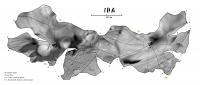
Here is a constant-scale natural boundary map of Ida that folds to a decent replica of the asteroid. Map edges are Ida's major ridges.[attachment=16299:Ida_MaxRidge_post.jpg]
[EDIT] Here it is again with the photomosaic properly credited; apologies to M. Nyrtsov for my oversight.
Attached thumbnail(s)
|
|
 |
 
|
|
 |
|
Nov 10 2008, 08:43 PM
Post
#2
|
|
 Member Group: Members Posts: 106 Joined: 26-September 05 Member No.: 508 |
By hand I presume you mean manually, no I will make them automatically.
I can probably convert them to WMF but DXF or CDR are more suitable if you are planning to cut them by laser. You can download the models from the PDS Small Bodies Node. Celestia keeps some of them in a more friendly 3DS format. |
|
|
|
|
Nov 10 2008, 08:46 PM
Post
#3
|
|
|
Member Group: Members Posts: 140 Joined: 20-November 07 Member No.: 3967 |
this may surprise you but I don't have much familiarity with those programs. DXF is the only acronym I recognize, and VectorWorks is the cad system i use for architectural drawing.
|
|
|
|
 chuckclark foldable map of Ida Oct 27 2008, 12:57 PM
 jumpjack QUOTE (chuckclark @ Oct 27 2008, 02:57 PM... Nov 6 2008, 08:24 AM
 dilo I tried with the aid of my son but result was very... Nov 6 2008, 03:07 PM chuckclark I've put it together twice -- I'll post a ... Nov 6 2008, 05:31 PM Phil Stooke Does my old friend Maxim Nyrtsov read this? Hi Ma... Nov 6 2008, 06:14 PM jumpjack It was difficult for me even to build a paper Eart... Nov 7 2008, 07:26 AM chuckclark jumpjack:
Here is a link Phobos Arts and Crafts th... Nov 7 2008, 02:16 PM jumpjack QUOTE (chuckclark @ Nov 7 2008, 04:16 PM)... Nov 10 2008, 08:12 AM Tayfun Öner I built the physical models that Chuck is using to... Nov 7 2008, 11:41 AM jumpjack QUOTE (Tayfun Öner @ Nov 7 2008, 01:41 PM... Nov 7 2008, 12:52 PM djellison What format are those models available in? Nov 7 2008, 12:13 PM Tayfun Öner I can convert the models to most popular formats. ... Nov 7 2008, 01:06 PM jumpjack QUOTE (Tayfun Öner @ Nov 7 2008, 03:06 PM... Nov 7 2008, 01:20 PM chuckclark OK, I corralled a photographer, (S. Adkins) to tak... Nov 10 2008, 01:33 PM Tayfun Öner Chuck the comparison photo is really impressive.
... Nov 10 2008, 03:13 PM jumpjack QUOTE (Tayfun Öner @ Nov 10 2008, 05:13 P... Nov 10 2008, 06:52 PM chuckclark Thanks, Tayfun. Like I say, the view from the oth... Nov 10 2008, 08:42 PM Tayfun Öner Here is a rendering from a similar angle. Nov 11 2008, 05:20 PM Tayfun Öner Here are the Phobos slices. As I don't know ho... Nov 11 2008, 06:00 PM chuckclark Well, so far so good. I downloaded and unzipped t... Nov 11 2008, 08:14 PM chuckclark QUOTE (Tayfun Öner @ Nov 11 2008, 01:00 P... Nov 15 2008, 06:54 PM chuckclark Okay, so borrowing a little from both systems, her... Nov 15 2008, 07:17 PM Tayfun Öner Chuck, that is brilliant. Here are your cuts both ... Nov 15 2008, 07:58 PM djellison GENIUS Nov 15 2008, 09:26 PM chuckclark QUOTE (djellison @ Nov 15 2008, 04:26 PM)... Nov 17 2008, 02:01 PM Phil Stooke Very interesting and entertaining stuff. I think ... Nov 17 2008, 04:10 PM Tayfun Öner Here are ribs for Eros. Nov 21 2008, 06:59 PM chuckclark QUOTE (Tayfun Öner @ Nov 21 2008, 01:59 P... Nov 21 2008, 10:02 PM Tayfun Öner Eros ribs updated, please note that north is up fo... Nov 22 2008, 10:56 AM jumpjack I just discovered that Google Sketchup can easily ... Dec 29 2008, 10:00 PM paxdan Here is a link to SliceModeler http://blog.makezin... Jan 6 2009, 06:08 PM jumpjack QUOTE (paxdan @ Jan 6 2009, 07:08 PM) Her... Jan 6 2009, 06:58 PM
dilo I tried with the aid of my son but result was very... Nov 6 2008, 03:07 PM chuckclark I've put it together twice -- I'll post a ... Nov 6 2008, 05:31 PM Phil Stooke Does my old friend Maxim Nyrtsov read this? Hi Ma... Nov 6 2008, 06:14 PM jumpjack It was difficult for me even to build a paper Eart... Nov 7 2008, 07:26 AM chuckclark jumpjack:
Here is a link Phobos Arts and Crafts th... Nov 7 2008, 02:16 PM jumpjack QUOTE (chuckclark @ Nov 7 2008, 04:16 PM)... Nov 10 2008, 08:12 AM Tayfun Öner I built the physical models that Chuck is using to... Nov 7 2008, 11:41 AM jumpjack QUOTE (Tayfun Öner @ Nov 7 2008, 01:41 PM... Nov 7 2008, 12:52 PM djellison What format are those models available in? Nov 7 2008, 12:13 PM Tayfun Öner I can convert the models to most popular formats. ... Nov 7 2008, 01:06 PM jumpjack QUOTE (Tayfun Öner @ Nov 7 2008, 03:06 PM... Nov 7 2008, 01:20 PM chuckclark OK, I corralled a photographer, (S. Adkins) to tak... Nov 10 2008, 01:33 PM Tayfun Öner Chuck the comparison photo is really impressive.
... Nov 10 2008, 03:13 PM jumpjack QUOTE (Tayfun Öner @ Nov 10 2008, 05:13 P... Nov 10 2008, 06:52 PM chuckclark Thanks, Tayfun. Like I say, the view from the oth... Nov 10 2008, 08:42 PM Tayfun Öner Here is a rendering from a similar angle. Nov 11 2008, 05:20 PM Tayfun Öner Here are the Phobos slices. As I don't know ho... Nov 11 2008, 06:00 PM chuckclark Well, so far so good. I downloaded and unzipped t... Nov 11 2008, 08:14 PM chuckclark QUOTE (Tayfun Öner @ Nov 11 2008, 01:00 P... Nov 15 2008, 06:54 PM chuckclark Okay, so borrowing a little from both systems, her... Nov 15 2008, 07:17 PM Tayfun Öner Chuck, that is brilliant. Here are your cuts both ... Nov 15 2008, 07:58 PM djellison GENIUS Nov 15 2008, 09:26 PM chuckclark QUOTE (djellison @ Nov 15 2008, 04:26 PM)... Nov 17 2008, 02:01 PM Phil Stooke Very interesting and entertaining stuff. I think ... Nov 17 2008, 04:10 PM Tayfun Öner Here are ribs for Eros. Nov 21 2008, 06:59 PM chuckclark QUOTE (Tayfun Öner @ Nov 21 2008, 01:59 P... Nov 21 2008, 10:02 PM Tayfun Öner Eros ribs updated, please note that north is up fo... Nov 22 2008, 10:56 AM jumpjack I just discovered that Google Sketchup can easily ... Dec 29 2008, 10:00 PM paxdan Here is a link to SliceModeler http://blog.makezin... Jan 6 2009, 06:08 PM jumpjack QUOTE (paxdan @ Jan 6 2009, 07:08 PM) Her... Jan 6 2009, 06:58 PM |

|
Lo-Fi Version | Time is now: 20th June 2024 - 01:54 AM |
|
RULES AND GUIDELINES Please read the Forum Rules and Guidelines before posting. IMAGE COPYRIGHT |
OPINIONS AND MODERATION Opinions expressed on UnmannedSpaceflight.com are those of the individual posters and do not necessarily reflect the opinions of UnmannedSpaceflight.com or The Planetary Society. The all-volunteer UnmannedSpaceflight.com moderation team is wholly independent of The Planetary Society. The Planetary Society has no influence over decisions made by the UnmannedSpaceflight.com moderators. |
SUPPORT THE FORUM Unmannedspaceflight.com is funded by the Planetary Society. Please consider supporting our work and many other projects by donating to the Society or becoming a member. |
|