Opportunity Route Map |

Opportunity Route Map |
 Feb 11 2005, 08:11 AM Feb 11 2005, 08:11 AM
Post
#1
|
||
 The Insider  Group: Members Posts: 669 Joined: 3-May 04 Member No.: 73 |
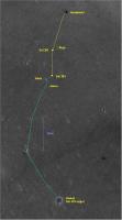
Here is an updated map of the road to Vostok.
Attached thumbnail(s)
|
|
 |
 
|
|
 |
|
Nov 10 2008, 07:07 PM
Post
#2
|
|
|
Member Group: Members Posts: 279 Joined: 19-August 07 Member No.: 3299 |
I am an occasional visitor to USMF. I got scared to see the long hop drives of Oppy. I am really interested in knowing exactly the route driving but I found the route map on the map to be mostly as a straight line except few intelligent zig zag in one day. I am puzzled on how Oppy has detected on the ahead obstacles in one day. I am supposing that the zig zag driving was already planned...
 My wishlist for this map is to have an exact Oppy's trayectory among crest of dunes. 
|
|
|
|
| Guest_Oersted_* |
Nov 11 2008, 11:41 AM
Post
#3
|
|
Guests |
Yes, Tesheiners wonderful maps are mainly a tool for keeping track of progress on a daily basis. From location to location. All the maneuvering in-between is not reflected, only major moves. I wonder if there are any maps out there which show it? All the data is there, wheel turns and drive directions and most importantly photos of the tracks left behind. I'd love to see a map with all the wiggles...
|
|
|
|
 Pando Opportunity Route Map Feb 11 2005, 08:11 AM
 djellison 800m marks? Nahh - that would just be added nois... Nov 2 2008, 10:22 AM
 centsworth_II QUOTE (djellison @ Nov 2 2008, 05:22 AM) ... Nov 2 2008, 06:47 PM Tesheiner Map update for sol 1700.
Nov 5 2008, 01:17 PM Tesheiner Update for sol 1702.
Nov 7 2008, 04:14 PM dvandorn Is it possible to annotate in some manner the rout... Nov 8 2008, 06:05 AM Tesheiner Actually, the map has already such thing, in some ... Nov 8 2008, 07:44 AM dvandorn Oh, sure, I knew you were trying to give a basic o... Nov 8 2008, 07:58 PM Tesheiner Update for sol 1704.
Nov 9 2008, 10:52 AM climber QUOTE (SpaceListener @ Nov 10 2008, 08:07... Nov 11 2008, 05:30 PM djellison Tesheiner already adds about as much info as we ca... Nov 11 2008, 03:08 PM Tesheiner > ... but that from today download
That's ... Nov 12 2008, 10:05 AM Oersted Thanks for the update Tesheiner! - We'll s... Nov 12 2008, 10:51 AM Tesheiner Map update for sol 1709.
Nov 14 2008, 10:17 PM Tesheiner ... and for sol 1710.
Nov 15 2008, 06:21 PM James Sorenson I know this is sort of a dumb question, but can an... Dec 16 2008, 08:01 AM djellison It could be
http://hirise.lpl.arizona.edu/TRA_0008... Dec 16 2008, 08:17 AM RoverDriver QUOTE (djellison @ Dec 16 2008, 12:17 AM)... Dec 16 2008, 04:35 PM Tesheiner I think it's time to post the whole map again.... Jan 16 2009, 10:11 PM Tesheiner Here's a crop of the map with the latest drive... Jan 20 2009, 11:12 AM ngunn half the scale? Jan 20 2009, 12:17 PM Tesheiner Exactly. I changed the map scale to 1m/pix.
I was ... Jan 20 2009, 02:43 PM Tesheiner Here's the rover's position as of sol 1776... Jan 22 2009, 09:46 AM Tesheiner Here's the route map now including another km ... Jan 26 2009, 09:09 PM Tesheiner Here's a snapshot around sol 1782 position.
Jan 28 2009, 08:33 PM charborob Opportunity is still moving generally S-W. Do you ... Jan 29 2009, 03:19 AM Tesheiner I hope so. See a discussion starting with fredk... Jan 29 2009, 07:00 AM Tesheiner Opportunity's updated position after sol 1784.... Jan 30 2009, 12:14 PM akuo Tesheiner, looks like that's the same map as 3... Jan 30 2009, 01:04 PM BrianL QUOTE (akuo @ Jan 30 2009, 07:04 AM) Tesh... Jan 30 2009, 01:37 PM jamescanvin Yes, looks like Oppy's off the bottom of that ... Jan 30 2009, 01:37 PM Tesheiner Oooops! Now corrected!
(It was posted at ... Jan 30 2009, 08:55 PM HughFromAlice QUOTE (Tesheiner @ Jan 31 2009, 06:25 AM)... Jan 30 2009, 10:37 PM Tesheiner Quick map update with the latest data from sol 178... Feb 2 2009, 11:30 AM algorimancer I've clearly been out of the loop for the past... Feb 2 2009, 06:33 PM Tesheiner I haven't seen any map with the projected path... Feb 6 2009, 08:06 PM Tesheiner The latest map as of sol 1793.
Feb 8 2009, 06:08 PM Tesheiner Just playing around...
Launch Google Earth, Selec... Feb 8 2009, 10:17 PM ElkGroveDan Brilliant! (can you do that from now on?) Feb 8 2009, 11:00 PM helvick I second that, it's an excellent addition to t... Feb 9 2009, 12:06 AM Floyd The smooth area immediately ahead looks to me like... Feb 9 2009, 01:28 AM BrianL QUOTE (Floyd @ Feb 8 2009, 07:28 PM) The ... Feb 9 2009, 01:31 AM Astro0 OMG!
TEsh, if you can keep doing that for t... Feb 9 2009, 05:11 AM Tesheiner Thanks, all. There'll be no problem to keep up... Feb 9 2009, 08:46 AM Stephen QUOTE (Tesheiner @ Feb 9 2009, 07:46 PM) ... Feb 9 2009, 09:42 AM ustrax QUOTE (Stephen @ Feb 9 2009, 09:42 AM) If... Feb 9 2009, 10:07 AM Tesheiner > If you do does this mean you won't be pos... Feb 9 2009, 01:23 PM Tesheiner A quick map update for sol 1795.
And the layer(s)... Feb 10 2009, 05:45 PM ustrax Tesheiner, from your map covering the whole distan... Feb 11 2009, 08:13 AM Tesheiner Here's a link (http://www.unmannedspaceflight.... Feb 11 2009, 10:00 AM ustrax Thanks Tesheiner! That was just what I was loo... Feb 11 2009, 11:06 AM Tesheiner Map update for sol 1797.
Feb 12 2009, 09:26 PM antoniseb Can someone please remind me what the scale of the... Feb 13 2009, 06:04 AM Tesheiner 100m. Feb 13 2009, 07:00 AM ElkGroveDan Wow, we're really moving now. Feb 13 2009, 03:56 PM Enceladus75 Fantastic progress is being made by Oppy at the mo... Feb 14 2009, 07:45 PM brellis Oppy's gotta be setting a 1 week distance reco... Feb 14 2009, 11:19 PM Tesheiner Not so fast. Today's drive was the shortest si... Feb 15 2009, 09:27 PM jamescanvin I thought it might help visualise our progress and... Feb 15 2009, 10:58 PM elakdawalla Great idea! One typo -- you credit someone na... Feb 15 2009, 11:08 PM jamescanvin So I did - fixed.
Thanks Emily. Feb 15 2009, 11:15 PM Greg Hullender Thanks, James. I was hoping someone would do that... Feb 16 2009, 05:18 AM Tesheiner Good idea James, specially the one with the ripple... Feb 16 2009, 06:59 AM Tesheiner Here we go with another map update: Sol 1803.
Feb 19 2009, 09:50 AM Tesheiner Sol1806: Another 60m to the odometer.
Feb 22 2009, 07:52 AM Dig Hello to all, although I read the forum for some t... Feb 23 2009, 10:34 AM djellison The one that works via Google is less accurate tha... Feb 23 2009, 11:03 AM Tesheiner Welcome to UMSF, Dig.
> Tesheiner, the layer o... Feb 23 2009, 11:42 AM Tesheiner I think it's time to post the "big pictur... Mar 1 2009, 08:59 PM MahFL When o when will we head SE ?
Does anyone know wha... Mar 2 2009, 06:43 PM centsworth_II QUOTE (MahFL @ Mar 2 2009, 01:43 PM) Does... Mar 2 2009, 08:07 PM Floyd Seems like someone (official or here at UMSF) sugg... Mar 2 2009, 10:23 PM MahFL Well they must have great faith that Oppy will be ... Mar 3 2009, 01:39 PM Tesheiner Map update corresponding to sol 1816. We might be ... Mar 5 2009, 06:09 PM Tesheiner Here's a quick update with information from so... Mar 6 2009, 12:56 PM remcook Nice long drive. Keep it up Oppy!
(edit: oops... Mar 6 2009, 01:19 PM Tesheiner Sol 1820.
Mar 8 2009, 08:43 PM Marsahod Why Oppy turned its way back? Mar 10 2009, 10:11 AM jamescanvin We don't know yet.
Discussion of this type sh... Mar 10 2009, 10:24 AM Tesheiner Update for sol 1824.
Mar 12 2009, 05:29 PM Tesheiner Small bump on sol 1825.
Added a new feature (Cook ... Mar 13 2009, 01:38 PM Tesheiner Wow, three weeks without posting any update here... Apr 8 2009, 09:26 AM Enceladus75 Hmmm. Oppy seems to be a long time at this one spo... Apr 8 2009, 07:21 PM Tesheiner I checked the attachment just to see if I posted t... Apr 8 2009, 07:54 PM Tesheiner Sol 1852.
Apr 10 2009, 11:03 AM Tesheiner Update after sol 1854, including names for the ... Apr 12 2009, 08:33 PM Tesheiner Update after driving during sol 1856.
Apr 14 2009, 02:25 PM Tesheiner Update after sol 1857.
Apr 15 2009, 02:20 PM Tesheiner A quick update after driving a few hours ago durin... Apr 17 2009, 10:12 AM Tesheiner Update after sol 1860.
Apr 18 2009, 01:54 PM ustrax Well...that's nice...
Looks like Oppy will t... Apr 18 2009, 05:55 PM Tesheiner Update after sol 1863.
Apr 21 2009, 02:13 PM Tesheiner Update after sol 1864.
Apr 22 2009, 04:26 PM Tesheiner Map update for sol 1867.
Apr 25 2009, 08:56 PM Tesheiner I guess it may be time to post the whole map again... Apr 28 2009, 04:26 PM Stu Great map, as usual, but they always leave me a bi... Apr 28 2009, 05:03 PM Tesheiner QUOTE (Stu @ Apr 28 2009, 07:03 PM) We... Apr 28 2009, 07:59 PM climber Can't get a hand on the big picture. As we... Apr 28 2009, 05:07 PM jamescanvin QUOTE (climber @ Apr 28 2009, 06:07 PM) I... Apr 28 2009, 05:35 PM
centsworth_II QUOTE (djellison @ Nov 2 2008, 05:22 AM) ... Nov 2 2008, 06:47 PM Tesheiner Map update for sol 1700.
Nov 5 2008, 01:17 PM Tesheiner Update for sol 1702.
Nov 7 2008, 04:14 PM dvandorn Is it possible to annotate in some manner the rout... Nov 8 2008, 06:05 AM Tesheiner Actually, the map has already such thing, in some ... Nov 8 2008, 07:44 AM dvandorn Oh, sure, I knew you were trying to give a basic o... Nov 8 2008, 07:58 PM Tesheiner Update for sol 1704.
Nov 9 2008, 10:52 AM climber QUOTE (SpaceListener @ Nov 10 2008, 08:07... Nov 11 2008, 05:30 PM djellison Tesheiner already adds about as much info as we ca... Nov 11 2008, 03:08 PM Tesheiner > ... but that from today download
That's ... Nov 12 2008, 10:05 AM Oersted Thanks for the update Tesheiner! - We'll s... Nov 12 2008, 10:51 AM Tesheiner Map update for sol 1709.
Nov 14 2008, 10:17 PM Tesheiner ... and for sol 1710.
Nov 15 2008, 06:21 PM James Sorenson I know this is sort of a dumb question, but can an... Dec 16 2008, 08:01 AM djellison It could be
http://hirise.lpl.arizona.edu/TRA_0008... Dec 16 2008, 08:17 AM RoverDriver QUOTE (djellison @ Dec 16 2008, 12:17 AM)... Dec 16 2008, 04:35 PM Tesheiner I think it's time to post the whole map again.... Jan 16 2009, 10:11 PM Tesheiner Here's a crop of the map with the latest drive... Jan 20 2009, 11:12 AM ngunn half the scale? Jan 20 2009, 12:17 PM Tesheiner Exactly. I changed the map scale to 1m/pix.
I was ... Jan 20 2009, 02:43 PM Tesheiner Here's the rover's position as of sol 1776... Jan 22 2009, 09:46 AM Tesheiner Here's the route map now including another km ... Jan 26 2009, 09:09 PM Tesheiner Here's a snapshot around sol 1782 position.
Jan 28 2009, 08:33 PM charborob Opportunity is still moving generally S-W. Do you ... Jan 29 2009, 03:19 AM Tesheiner I hope so. See a discussion starting with fredk... Jan 29 2009, 07:00 AM Tesheiner Opportunity's updated position after sol 1784.... Jan 30 2009, 12:14 PM akuo Tesheiner, looks like that's the same map as 3... Jan 30 2009, 01:04 PM BrianL QUOTE (akuo @ Jan 30 2009, 07:04 AM) Tesh... Jan 30 2009, 01:37 PM jamescanvin Yes, looks like Oppy's off the bottom of that ... Jan 30 2009, 01:37 PM Tesheiner Oooops! Now corrected!
(It was posted at ... Jan 30 2009, 08:55 PM HughFromAlice QUOTE (Tesheiner @ Jan 31 2009, 06:25 AM)... Jan 30 2009, 10:37 PM Tesheiner Quick map update with the latest data from sol 178... Feb 2 2009, 11:30 AM algorimancer I've clearly been out of the loop for the past... Feb 2 2009, 06:33 PM Tesheiner I haven't seen any map with the projected path... Feb 6 2009, 08:06 PM Tesheiner The latest map as of sol 1793.
Feb 8 2009, 06:08 PM Tesheiner Just playing around...
Launch Google Earth, Selec... Feb 8 2009, 10:17 PM ElkGroveDan Brilliant! (can you do that from now on?) Feb 8 2009, 11:00 PM helvick I second that, it's an excellent addition to t... Feb 9 2009, 12:06 AM Floyd The smooth area immediately ahead looks to me like... Feb 9 2009, 01:28 AM BrianL QUOTE (Floyd @ Feb 8 2009, 07:28 PM) The ... Feb 9 2009, 01:31 AM Astro0 OMG!
TEsh, if you can keep doing that for t... Feb 9 2009, 05:11 AM Tesheiner Thanks, all. There'll be no problem to keep up... Feb 9 2009, 08:46 AM Stephen QUOTE (Tesheiner @ Feb 9 2009, 07:46 PM) ... Feb 9 2009, 09:42 AM ustrax QUOTE (Stephen @ Feb 9 2009, 09:42 AM) If... Feb 9 2009, 10:07 AM Tesheiner > If you do does this mean you won't be pos... Feb 9 2009, 01:23 PM Tesheiner A quick map update for sol 1795.
And the layer(s)... Feb 10 2009, 05:45 PM ustrax Tesheiner, from your map covering the whole distan... Feb 11 2009, 08:13 AM Tesheiner Here's a link (http://www.unmannedspaceflight.... Feb 11 2009, 10:00 AM ustrax Thanks Tesheiner! That was just what I was loo... Feb 11 2009, 11:06 AM Tesheiner Map update for sol 1797.
Feb 12 2009, 09:26 PM antoniseb Can someone please remind me what the scale of the... Feb 13 2009, 06:04 AM Tesheiner 100m. Feb 13 2009, 07:00 AM ElkGroveDan Wow, we're really moving now. Feb 13 2009, 03:56 PM Enceladus75 Fantastic progress is being made by Oppy at the mo... Feb 14 2009, 07:45 PM brellis Oppy's gotta be setting a 1 week distance reco... Feb 14 2009, 11:19 PM Tesheiner Not so fast. Today's drive was the shortest si... Feb 15 2009, 09:27 PM jamescanvin I thought it might help visualise our progress and... Feb 15 2009, 10:58 PM elakdawalla Great idea! One typo -- you credit someone na... Feb 15 2009, 11:08 PM jamescanvin So I did - fixed.
Thanks Emily. Feb 15 2009, 11:15 PM Greg Hullender Thanks, James. I was hoping someone would do that... Feb 16 2009, 05:18 AM Tesheiner Good idea James, specially the one with the ripple... Feb 16 2009, 06:59 AM Tesheiner Here we go with another map update: Sol 1803.
Feb 19 2009, 09:50 AM Tesheiner Sol1806: Another 60m to the odometer.
Feb 22 2009, 07:52 AM Dig Hello to all, although I read the forum for some t... Feb 23 2009, 10:34 AM djellison The one that works via Google is less accurate tha... Feb 23 2009, 11:03 AM Tesheiner Welcome to UMSF, Dig.
> Tesheiner, the layer o... Feb 23 2009, 11:42 AM Tesheiner I think it's time to post the "big pictur... Mar 1 2009, 08:59 PM MahFL When o when will we head SE ?
Does anyone know wha... Mar 2 2009, 06:43 PM centsworth_II QUOTE (MahFL @ Mar 2 2009, 01:43 PM) Does... Mar 2 2009, 08:07 PM Floyd Seems like someone (official or here at UMSF) sugg... Mar 2 2009, 10:23 PM MahFL Well they must have great faith that Oppy will be ... Mar 3 2009, 01:39 PM Tesheiner Map update corresponding to sol 1816. We might be ... Mar 5 2009, 06:09 PM Tesheiner Here's a quick update with information from so... Mar 6 2009, 12:56 PM remcook Nice long drive. Keep it up Oppy!
(edit: oops... Mar 6 2009, 01:19 PM Tesheiner Sol 1820.
Mar 8 2009, 08:43 PM Marsahod Why Oppy turned its way back? Mar 10 2009, 10:11 AM jamescanvin We don't know yet.
Discussion of this type sh... Mar 10 2009, 10:24 AM Tesheiner Update for sol 1824.
Mar 12 2009, 05:29 PM Tesheiner Small bump on sol 1825.
Added a new feature (Cook ... Mar 13 2009, 01:38 PM Tesheiner Wow, three weeks without posting any update here... Apr 8 2009, 09:26 AM Enceladus75 Hmmm. Oppy seems to be a long time at this one spo... Apr 8 2009, 07:21 PM Tesheiner I checked the attachment just to see if I posted t... Apr 8 2009, 07:54 PM Tesheiner Sol 1852.
Apr 10 2009, 11:03 AM Tesheiner Update after sol 1854, including names for the ... Apr 12 2009, 08:33 PM Tesheiner Update after driving during sol 1856.
Apr 14 2009, 02:25 PM Tesheiner Update after sol 1857.
Apr 15 2009, 02:20 PM Tesheiner A quick update after driving a few hours ago durin... Apr 17 2009, 10:12 AM Tesheiner Update after sol 1860.
Apr 18 2009, 01:54 PM ustrax Well...that's nice...
Looks like Oppy will t... Apr 18 2009, 05:55 PM Tesheiner Update after sol 1863.
Apr 21 2009, 02:13 PM Tesheiner Update after sol 1864.
Apr 22 2009, 04:26 PM Tesheiner Map update for sol 1867.
Apr 25 2009, 08:56 PM Tesheiner I guess it may be time to post the whole map again... Apr 28 2009, 04:26 PM Stu Great map, as usual, but they always leave me a bi... Apr 28 2009, 05:03 PM Tesheiner QUOTE (Stu @ Apr 28 2009, 07:03 PM) We... Apr 28 2009, 07:59 PM climber Can't get a hand on the big picture. As we... Apr 28 2009, 05:07 PM jamescanvin QUOTE (climber @ Apr 28 2009, 06:07 PM) I... Apr 28 2009, 05:35 PM |

|
Lo-Fi Version | Time is now: 22nd September 2024 - 02:48 PM |
|
RULES AND GUIDELINES Please read the Forum Rules and Guidelines before posting. IMAGE COPYRIGHT |
OPINIONS AND MODERATION Opinions expressed on UnmannedSpaceflight.com are those of the individual posters and do not necessarily reflect the opinions of UnmannedSpaceflight.com or The Planetary Society. The all-volunteer UnmannedSpaceflight.com moderation team is wholly independent of The Planetary Society. The Planetary Society has no influence over decisions made by the UnmannedSpaceflight.com moderators. |
SUPPORT THE FORUM Unmannedspaceflight.com is funded by the Planetary Society. Please consider supporting our work and many other projects by donating to the Society or becoming a member. |
|