Martian Cartography |

Martian Cartography |
 May 15 2006, 04:16 PM May 15 2006, 04:16 PM
Post
#1
|
|
|
Member  Group: Members Posts: 147 Joined: 14-April 06 From: Berlin Member No.: 744 |
I have recently freaked out a little bit about Martian maps of all sorts. And finally I was astonished with those highly detailed beauties that I list below. Nonetheless. some of them have huge inconsistencies (crater names) easily noticed when we compare the surroundings of Gusev crater. Enjoy:
http://www.ralphaeschliman.com/ http://planetologia.elte.hu/1cikkeke.phtml...arsmapinte.html http://pubs.usgs.gov/imap/i2782/ -------------------- |
 |
 
|
 |
|
Jan 23 2009, 02:55 PM
Post
#2
|
||
|
Solar System Cartographer Group: Members Posts: 10229 Joined: 5-April 05 From: Canada Member No.: 227 |
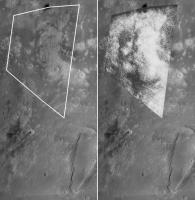
Here is a comparison between a MOC wide-angle mosaic - courtesy of Malin Space Science Systems - and a reprojected version of Mariner 4 frame 1. I can't recall seeing this frame matched to topography before (correct me if I'm wrong). At the time I think people said many features were likely atmospheric rather than on the surface, but this comparison shows a very close match even to the smallest bright spots on the surface. It also suggests only the most trivial changes have occurred in this area. Orcus Patera at bottom right gives the location. Blinking the two halves reinforces the close match.
Phil
-------------------- ... because the Solar System ain't gonna map itself.
Also to be found posting similar content on https://mastodon.social/@PhilStooke Maps for download (free PDF: https://upload.wikimedia.org/wikipedia/comm...Cartography.pdf NOTE: everything created by me which I post on UMSF is considered to be in the public domain (NOT CC, public domain) |
|
|
|
|
|
|
Feb 5 2009, 01:45 AM
Post
#3
|
|||
 Interplanetary Dumpster Diver Group: Admin Posts: 4404 Joined: 17-February 04 From: Powell, TN Member No.: 33 |
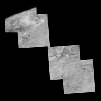
QUOTE (Phil Stooke @ Jan 23 2009, 03:55 PM)  Here is a comparison between a MOC wide-angle mosaic - courtesy of Malin Space Science Systems - and a reprojected version of Mariner 4 frame 1. I can't recall seeing this frame matched to topography before (correct me if I'm wrong). At the time I think people said many features were likely atmospheric rather than on the surface, but this comparison shows a very close match even to the smallest bright spots on the surface. It also suggests only the most trivial changes have occurred in this area. Orcus Patera at bottom right gives the location. Blinking the two halves reinforces the close match. Phil This makes sense, based on my mosaic of the first four frames.
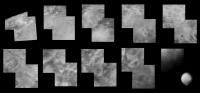
Here is my complete set of two frame mosaics....the image in the lower right hand corner is a telescopic view of the area taken around the time of the flyby.
-------------------- |
||
|
|
|
||
 karolp Martian Cartography May 15 2006, 04:16 PM
 PhilCo126 http://marsoweb.nas.nasa.gov/dataViz/ May 21 2006, 03:26 PM Phil Stooke karolp, I have looked at these maps, and I don... May 21 2006, 04:21 PM DonPMitchell I like the second USGS map.
Nice hill shading, ... May 22 2006, 05:35 PM
PhilCo126 http://marsoweb.nas.nasa.gov/dataViz/ May 21 2006, 03:26 PM Phil Stooke karolp, I have looked at these maps, and I don... May 21 2006, 04:21 PM DonPMitchell I like the second USGS map.
Nice hill shading, ... May 22 2006, 05:35 PM chuckclark Here are two constant-scale natural boundary maps ... Nov 23 2007, 06:58 PM
 AndyG Hi Don,
Mapping is an ancient art, and I'm a ... Jan 11 2009, 11:36 AM PhilCo126 About three years ago, I've written an article... Nov 23 2007, 07:34 PM Phil Stooke here's an interesting comparison if anyone... Jan 9 2009, 08:59 PM tedstryk I have a set going back to I think the 1890s...If ... Jan 10 2009, 01:38 PM dvandorn Great comparison presentation, Phil. Very easy to... Jan 10 2009, 05:22 AM Phil Stooke Very true, Doug. The top image was produced in a ... Jan 10 2009, 01:08 PM Phil Stooke Speaking of ancient art... here's a map of Mar... Jan 15 2009, 08:53 PM Phil Stooke ... and here's Mars seen by Mariner 7, far enc... Jan 21 2009, 09:15 PM elakdawalla Very cool. Mars comes in to focus. Thanks for po... Jan 21 2009, 10:14 PM mcaplinger QUOTE (elakdawalla @ Jan 21 2009, 02:14 P... Jan 22 2009, 12:13 AM Phil Stooke Not really - shifts between these mariner maps, an... Jan 21 2009, 11:28 PM tedstryk Excellent work! I have worked with a lot of t... Feb 5 2009, 01:34 AM Phil Stooke This is Mars as it was known just after the Marine... Feb 1 2009, 09:04 PM PhilCo126 This is a nice poster: Mariner IV Mars flyby 1965 Feb 2 2009, 06:17 PM Phil Stooke It's a very nice poster, but the locations of ... Feb 2 2009, 06:27 PM Tayfun Öner QUOTE (Phil Stooke @ Feb 2 2009, 08:27 PM... Feb 2 2009, 08:48 PM Phil Stooke Don't worry, you didn't do it incorrectly,... Feb 2 2009, 09:13 PM Phil Stooke Here's the very beginning of Mars cartography.... Feb 4 2009, 05:22 PM Phil Stooke I posted a map showing Mars as it was known after ... Feb 23 2009, 04:07 PM Byran Main results current and history cartography Mars
... Feb 26 2009, 01:03 PM djellison You can scrap MEX from your last line. It can... Feb 26 2009, 02:08 PM Byran 10% were not precise calculations, but just at ran... Feb 26 2009, 02:50 PM Phil Stooke Here is a very unusual Mars map - in two different... Aug 27 2009, 09:28 PM stevesliva Schiaparelli? Wasn't my first guess. Lowell wa... Aug 27 2009, 11:38 PM Phil Stooke No, but from the same period as Schiaparelli - eve... Aug 28 2009, 12:25 AM nprev WAG based on a half-memory: Herschel? Aug 28 2009, 12:44 AM Phil Stooke You Doofus! No... He was 100 years before the... Aug 28 2009, 12:50 AM nprev ...sorry, haven't been drinking enough lately... Aug 28 2009, 12:53 AM Simon_Frazier Hi Phil:
I think this might be Dawes' work. ... Aug 28 2009, 02:16 AM mhoward Hmm. Flammarion? Looks similar, but different. Aug 28 2009, 02:20 AM volcanopele Asaph Hall? Aug 28 2009, 02:51 AM Phil Stooke Simon is close... but Dawes was the observer, not ... Aug 28 2009, 03:02 AM mhoward Proctor, then? I wouldn't have guessed that. Aug 28 2009, 03:19 AM Phil Stooke Excellent - now we have the cartographer, Richard ... Aug 28 2009, 03:25 AM stevesliva QUOTE (Phil Stooke @ Aug 27 2009, 10:25 P... Aug 28 2009, 04:01 AM nprev Okay, an attempt at redemption: Proctor's Othe... Aug 28 2009, 06:17 AM Phil Stooke No, the 'Other Worlds' map was his first, ... Aug 28 2009, 11:21 AM stevesliva QUOTE (Phil Stooke @ Aug 28 2009, 06:21 A... Aug 28 2009, 04:35 PM centsworth_II QUOTE (stevesliva @ Aug 28 2009, 12:35 PM... Aug 28 2009, 04:50 PM Phil Stooke Right - the fertile Nile Valley is much wider than... Aug 28 2009, 06:30 PM MarsIsImportant Those maps are interesting from an historical aspe... Aug 31 2009, 12:59 AM Phil Stooke Here's the answer to my map question - the map... Aug 31 2009, 09:11 PM djellison Snow on the poles. I think he can be quite proud ... Aug 31 2009, 09:27 PM nprev Very cool map, thanks for educating (me, at least)... Sep 1 2009, 12:27 AM elakdawalla I like "windy land." Is that Hellas? A... Sep 1 2009, 05:07 AM Phil Stooke This original map is south up - mine was north up.... Sep 1 2009, 10:48 AM JohnVV QUOTE It's a nice tour down memory lane.
i hav... Oct 1 2009, 06:14 AM Phil Stooke Here's another oldie but goldie:
The 1783 map... Oct 1 2009, 08:13 PM JohnVV Phil I did not know of that one
from 1783 cool Oct 2 2009, 09:06 PM Phil Stooke Here are a couple of other early maps which I have... Oct 22 2009, 01:31 PM Phil Stooke I've added an illustration showing five histor... Oct 22 2009, 03:56 PM ElkGroveDan Phil I really love the Lunar Book. I can't wa... Oct 22 2009, 04:01 PM machi I did my first map - Martian topography map.
I su... Jun 25 2012, 01:09 AM djellison I especially love the color scale used - very nice... Jun 25 2012, 05:29 AM vikingmars QUOTE (machi @ Jun 25 2012, 03:09 AM)
CO... Jun 25 2012, 06:12 PM Phil Stooke Nice map! One comment - the position for Mars... Jun 25 2012, 02:44 AM machi QUOTE (Phil Stooke @ Jun 25 2012, 04:44 A... Jun 25 2012, 07:21 PM vikingmars QUOTE (machi @ Jun 25 2012, 09:21 PM) Thi... Jun 25 2012, 08:55 PM machi "Did you make a more detailed hi-res elevatio... Jun 25 2012, 10:00 PM vikingmars QUOTE (machi @ Jun 26 2012, 12:00 AM) Her... Jun 26 2012, 10:10 AM machi Finally I did blog entry about my map.
I downloade... Jun 26 2012, 06:21 PM machi I have uploaded new (fifth) version of my topograp... Dec 11 2012, 11:25 PM TheAnt Thank you machi, wonderful map. I spent quite some... Dec 14 2012, 06:56 PM machi You're welcome!
But old maps are mostly p... Dec 14 2012, 07:59 PM TheAnt Yes I felt it as a good time to make a nod to Phil... Dec 14 2012, 08:32 PM machi I see that I promised post about lowest and highes... Dec 14 2012, 08:35 PM vikingmars QUOTE (machi @ Dec 14 2012, 09:35 PM) I s... Dec 27 2012, 08:28 AM Lucas There is a new geologic map of Mars that was recen... Jul 23 2014, 07:09 PM machi I've just published my new topographic map of ... Nov 3 2014, 01:16 AM vikingmars QUOTE (machi @ Nov 3 2014, 02:16 AM) I... Nov 3 2014, 09:45 PM Bjorn Jonsson Very impressive work. And Google translate apparen... Nov 3 2014, 09:59 PM machi You're welcome!
QUOTE (Bjorn Jonsson ... Nov 6 2014, 07:00 PM machi New version of my topographic map of Mars is now a... Jan 25 2015, 11:21 PM vikingmars QUOTE (machi @ Jan 26 2015, 12:21 AM) .... Jan 26 2015, 10:48 AM machi You're welcome!
Closest measurement from M... Jan 26 2015, 10:47 PM djellison QUOTE (machi @ Jan 26 2015, 02:47 PM) BTW... Jan 26 2015, 10:51 PM machi QUOTE (djellison @ Jan 26 2015, 11:51 PM)... Jan 26 2015, 11:06 PM vikingmars QUOTE (machi @ Jan 26 2015, 11:47 PM) You... Jan 26 2015, 10:52 PM machi My apology, as in previous version, I forgot Czech... Jan 27 2015, 10:42 AM machi Updated version of my map with all official names ... Jan 15 2016, 02:12 AM vikingmars [quote name='machi' date='Jan 15 2016,... Jan 20 2016, 09:04 AM serpens Interesting to match Machi's stunning topograp... Apr 12 2016, 01:52 AM kamkaran what a nice photos Dec 8 2016, 11:17 AM Rain https://www.voxxlr.com/1531074107806
My Mars mode... Nov 28 2018, 10:36 AM RoverDriver QUOTE (Rain @ Nov 28 2018, 02:36 AM) http... Nov 28 2018, 03:00 PM machi QUOTE (Rain @ Nov 28 2018, 11:36 AM) http... Jan 9 2019, 06:01 PM kymani76 I am currently doing some Mars cartography work an... Jan 7 2019, 08:02 PM Phil Stooke I don't know, but I looked at the traverse map... Jan 9 2019, 04:58 AM kymani76 QUOTE (Phil Stooke @ Jan 9 2019, 05:58 AM... Jan 11 2019, 12:14 PM machi New version (1.2) of my Topographic Map of Mars.
... Jan 9 2019, 09:45 PM vikingmars [quote name='machi' date='Jan 9 2019, ... Jan 10 2019, 06:02 PM machi Thank you!
I would recommend HRSC result. MOL... Jan 11 2019, 01:38 AM vikingmars QUOTE (machi @ Jan 11 2019, 02:38 AM) Tha... Jan 11 2019, 09:53 AM
AndyG Hi Don,
Mapping is an ancient art, and I'm a ... Jan 11 2009, 11:36 AM PhilCo126 About three years ago, I've written an article... Nov 23 2007, 07:34 PM Phil Stooke here's an interesting comparison if anyone... Jan 9 2009, 08:59 PM tedstryk I have a set going back to I think the 1890s...If ... Jan 10 2009, 01:38 PM dvandorn Great comparison presentation, Phil. Very easy to... Jan 10 2009, 05:22 AM Phil Stooke Very true, Doug. The top image was produced in a ... Jan 10 2009, 01:08 PM Phil Stooke Speaking of ancient art... here's a map of Mar... Jan 15 2009, 08:53 PM Phil Stooke ... and here's Mars seen by Mariner 7, far enc... Jan 21 2009, 09:15 PM elakdawalla Very cool. Mars comes in to focus. Thanks for po... Jan 21 2009, 10:14 PM mcaplinger QUOTE (elakdawalla @ Jan 21 2009, 02:14 P... Jan 22 2009, 12:13 AM Phil Stooke Not really - shifts between these mariner maps, an... Jan 21 2009, 11:28 PM tedstryk Excellent work! I have worked with a lot of t... Feb 5 2009, 01:34 AM Phil Stooke This is Mars as it was known just after the Marine... Feb 1 2009, 09:04 PM PhilCo126 This is a nice poster: Mariner IV Mars flyby 1965 Feb 2 2009, 06:17 PM Phil Stooke It's a very nice poster, but the locations of ... Feb 2 2009, 06:27 PM Tayfun Öner QUOTE (Phil Stooke @ Feb 2 2009, 08:27 PM... Feb 2 2009, 08:48 PM Phil Stooke Don't worry, you didn't do it incorrectly,... Feb 2 2009, 09:13 PM Phil Stooke Here's the very beginning of Mars cartography.... Feb 4 2009, 05:22 PM Phil Stooke I posted a map showing Mars as it was known after ... Feb 23 2009, 04:07 PM Byran Main results current and history cartography Mars
... Feb 26 2009, 01:03 PM djellison You can scrap MEX from your last line. It can... Feb 26 2009, 02:08 PM Byran 10% were not precise calculations, but just at ran... Feb 26 2009, 02:50 PM Phil Stooke Here is a very unusual Mars map - in two different... Aug 27 2009, 09:28 PM stevesliva Schiaparelli? Wasn't my first guess. Lowell wa... Aug 27 2009, 11:38 PM Phil Stooke No, but from the same period as Schiaparelli - eve... Aug 28 2009, 12:25 AM nprev WAG based on a half-memory: Herschel? Aug 28 2009, 12:44 AM Phil Stooke You Doofus! No... He was 100 years before the... Aug 28 2009, 12:50 AM nprev ...sorry, haven't been drinking enough lately... Aug 28 2009, 12:53 AM Simon_Frazier Hi Phil:
I think this might be Dawes' work. ... Aug 28 2009, 02:16 AM mhoward Hmm. Flammarion? Looks similar, but different. Aug 28 2009, 02:20 AM volcanopele Asaph Hall? Aug 28 2009, 02:51 AM Phil Stooke Simon is close... but Dawes was the observer, not ... Aug 28 2009, 03:02 AM mhoward Proctor, then? I wouldn't have guessed that. Aug 28 2009, 03:19 AM Phil Stooke Excellent - now we have the cartographer, Richard ... Aug 28 2009, 03:25 AM stevesliva QUOTE (Phil Stooke @ Aug 27 2009, 10:25 P... Aug 28 2009, 04:01 AM nprev Okay, an attempt at redemption: Proctor's Othe... Aug 28 2009, 06:17 AM Phil Stooke No, the 'Other Worlds' map was his first, ... Aug 28 2009, 11:21 AM stevesliva QUOTE (Phil Stooke @ Aug 28 2009, 06:21 A... Aug 28 2009, 04:35 PM centsworth_II QUOTE (stevesliva @ Aug 28 2009, 12:35 PM... Aug 28 2009, 04:50 PM Phil Stooke Right - the fertile Nile Valley is much wider than... Aug 28 2009, 06:30 PM MarsIsImportant Those maps are interesting from an historical aspe... Aug 31 2009, 12:59 AM Phil Stooke Here's the answer to my map question - the map... Aug 31 2009, 09:11 PM djellison Snow on the poles. I think he can be quite proud ... Aug 31 2009, 09:27 PM nprev Very cool map, thanks for educating (me, at least)... Sep 1 2009, 12:27 AM elakdawalla I like "windy land." Is that Hellas? A... Sep 1 2009, 05:07 AM Phil Stooke This original map is south up - mine was north up.... Sep 1 2009, 10:48 AM JohnVV QUOTE It's a nice tour down memory lane.
i hav... Oct 1 2009, 06:14 AM Phil Stooke Here's another oldie but goldie:
The 1783 map... Oct 1 2009, 08:13 PM JohnVV Phil I did not know of that one
from 1783 cool Oct 2 2009, 09:06 PM Phil Stooke Here are a couple of other early maps which I have... Oct 22 2009, 01:31 PM Phil Stooke I've added an illustration showing five histor... Oct 22 2009, 03:56 PM ElkGroveDan Phil I really love the Lunar Book. I can't wa... Oct 22 2009, 04:01 PM machi I did my first map - Martian topography map.
I su... Jun 25 2012, 01:09 AM djellison I especially love the color scale used - very nice... Jun 25 2012, 05:29 AM vikingmars QUOTE (machi @ Jun 25 2012, 03:09 AM)
CO... Jun 25 2012, 06:12 PM Phil Stooke Nice map! One comment - the position for Mars... Jun 25 2012, 02:44 AM machi QUOTE (Phil Stooke @ Jun 25 2012, 04:44 A... Jun 25 2012, 07:21 PM vikingmars QUOTE (machi @ Jun 25 2012, 09:21 PM) Thi... Jun 25 2012, 08:55 PM machi "Did you make a more detailed hi-res elevatio... Jun 25 2012, 10:00 PM vikingmars QUOTE (machi @ Jun 26 2012, 12:00 AM) Her... Jun 26 2012, 10:10 AM machi Finally I did blog entry about my map.
I downloade... Jun 26 2012, 06:21 PM machi I have uploaded new (fifth) version of my topograp... Dec 11 2012, 11:25 PM TheAnt Thank you machi, wonderful map. I spent quite some... Dec 14 2012, 06:56 PM machi You're welcome!
But old maps are mostly p... Dec 14 2012, 07:59 PM TheAnt Yes I felt it as a good time to make a nod to Phil... Dec 14 2012, 08:32 PM machi I see that I promised post about lowest and highes... Dec 14 2012, 08:35 PM vikingmars QUOTE (machi @ Dec 14 2012, 09:35 PM) I s... Dec 27 2012, 08:28 AM Lucas There is a new geologic map of Mars that was recen... Jul 23 2014, 07:09 PM machi I've just published my new topographic map of ... Nov 3 2014, 01:16 AM vikingmars QUOTE (machi @ Nov 3 2014, 02:16 AM) I... Nov 3 2014, 09:45 PM Bjorn Jonsson Very impressive work. And Google translate apparen... Nov 3 2014, 09:59 PM machi You're welcome!
QUOTE (Bjorn Jonsson ... Nov 6 2014, 07:00 PM machi New version of my topographic map of Mars is now a... Jan 25 2015, 11:21 PM vikingmars QUOTE (machi @ Jan 26 2015, 12:21 AM) .... Jan 26 2015, 10:48 AM machi You're welcome!
Closest measurement from M... Jan 26 2015, 10:47 PM djellison QUOTE (machi @ Jan 26 2015, 02:47 PM) BTW... Jan 26 2015, 10:51 PM machi QUOTE (djellison @ Jan 26 2015, 11:51 PM)... Jan 26 2015, 11:06 PM vikingmars QUOTE (machi @ Jan 26 2015, 11:47 PM) You... Jan 26 2015, 10:52 PM machi My apology, as in previous version, I forgot Czech... Jan 27 2015, 10:42 AM machi Updated version of my map with all official names ... Jan 15 2016, 02:12 AM vikingmars [quote name='machi' date='Jan 15 2016,... Jan 20 2016, 09:04 AM serpens Interesting to match Machi's stunning topograp... Apr 12 2016, 01:52 AM kamkaran what a nice photos Dec 8 2016, 11:17 AM Rain https://www.voxxlr.com/1531074107806
My Mars mode... Nov 28 2018, 10:36 AM RoverDriver QUOTE (Rain @ Nov 28 2018, 02:36 AM) http... Nov 28 2018, 03:00 PM machi QUOTE (Rain @ Nov 28 2018, 11:36 AM) http... Jan 9 2019, 06:01 PM kymani76 I am currently doing some Mars cartography work an... Jan 7 2019, 08:02 PM Phil Stooke I don't know, but I looked at the traverse map... Jan 9 2019, 04:58 AM kymani76 QUOTE (Phil Stooke @ Jan 9 2019, 05:58 AM... Jan 11 2019, 12:14 PM machi New version (1.2) of my Topographic Map of Mars.
... Jan 9 2019, 09:45 PM vikingmars [quote name='machi' date='Jan 9 2019, ... Jan 10 2019, 06:02 PM machi Thank you!
I would recommend HRSC result. MOL... Jan 11 2019, 01:38 AM vikingmars QUOTE (machi @ Jan 11 2019, 02:38 AM) Tha... Jan 11 2019, 09:53 AM |

|
Lo-Fi Version | Time is now: 26th September 2024 - 10:02 AM |
|
RULES AND GUIDELINES Please read the Forum Rules and Guidelines before posting. IMAGE COPYRIGHT |
OPINIONS AND MODERATION Opinions expressed on UnmannedSpaceflight.com are those of the individual posters and do not necessarily reflect the opinions of UnmannedSpaceflight.com or The Planetary Society. The all-volunteer UnmannedSpaceflight.com moderation team is wholly independent of The Planetary Society. The Planetary Society has no influence over decisions made by the UnmannedSpaceflight.com moderators. |
SUPPORT THE FORUM Unmannedspaceflight.com is funded by the Planetary Society. Please consider supporting our work and many other projects by donating to the Society or becoming a member. |
|