Mars 3 (Various Topics Merged) |

Mars 3 (Various Topics Merged) |
 Dec 29 2004, 10:36 PM Dec 29 2004, 10:36 PM
Post
#1
|
|
 Interplanetary Dumpster Diver  Group: Admin Posts: 4404 Joined: 17-February 04 From: Powell, TN Member No.: 33 |
On my website sometime back, I added a page on the image fragment sent back by the Mars-3 Lander. I released serveral versions, including the best quality processing using othodox techniques I would use on other images plus colorization here:
http://pages.preferred.com/%7Etedstryk/fragmentc.jpg However, I released another image, which I called a "What if" image. This image can be seen here http://pages.preferred.com/%7Etedstryk/m3s5b.jpg It was produced via extreme processing of the original data to make a Mars-like scene, but I made it clear on my website it was only a speculative image. I strongly doubt if the raw data even shows Mars at all - it could be all noise. But since this mode of processing looked strangely Viking-like, I figured I would put it on the web. I was warned by several, who said that while fun, some kooks might take it seriously. My response was that I really don't care what kooks think. Then I noticed this web page: http://en.wikipedia.org/wiki/Mars_2 They used the overprocessed image. I feel like it is being presented as a true photograph. This is of concern. -------------------- |
 |
 
|
 |
|
Feb 14 2009, 05:41 AM
Post
#2
|
||
 Member Group: Members Posts: 236 Joined: 5-June 08 From: Udon Thani Member No.: 4185 |
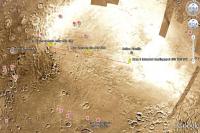
Forgot to mention that according to the above reasoning, the crash location of Mars 2 must be to the WEST of Hellas, as we know it entered too steep. So it must be at least 300 km west of its intended spot (atmospheric entry angle must have been more then 5 degrees too steep, otherwise it would have survived), and it is likely no more then let's say 1500 km to the west (given the final orbit of the mothership) but definitely no more then 3100 km west of Hellas (otherwise the mothership would have burned up). It remains a big, big area...
Track projected on Google Mars. If we assume a landing error of 700 km (which correspondents with a most likely offtrack of 150 km, given the mothership entered an orbit with 1350 km perigree instead of 1500 km) then the targeted landing site would be close to 45S 70E which is almost dead centre in Hellas. I am trying to find out whether this area is inside one of the Mariner 7 images. Anyway, no matter how I try I can't get Mars 2 to end up anywhere near 4 N. This also does not work out with the mothership ending up in an orbit with a 49 degree inclination, given the relatively small impuls of the lander-engine the atmospheric entry point must be close to the groundtrack of the mothership, which is conform with the 45 deg South locations but definitely does not work out for any location on the northerly hemisphere. Regards, Geert. |
|
|
|
|
|
 tedstryk Mars 3 (Various Topics Merged) Dec 29 2004, 10:36 PM
 lyford Since it's Wikipedia, can't you just delet... Dec 29 2004, 11:09 PM tedstryk Thanks. I will be updating the Phobos-2 section s... Dec 30 2004, 01:12 AM PhilHorzempa [size=2]
With regard to the Soviet Mars lan... Apr 18 2006, 10:02 PM BruceMoomaw The Soviets actually do firmly know why Mars 2 fai... Apr 18 2006, 10:18 PM
lyford Since it's Wikipedia, can't you just delet... Dec 29 2004, 11:09 PM tedstryk Thanks. I will be updating the Phobos-2 section s... Dec 30 2004, 01:12 AM PhilHorzempa [size=2]
With regard to the Soviet Mars lan... Apr 18 2006, 10:02 PM BruceMoomaw The Soviets actually do firmly know why Mars 2 fai... Apr 18 2006, 10:18 PM tedstryk QUOTE (BruceMoomaw @ Apr 18 2006, 10:18 P... Apr 18 2006, 10:41 PM
 The Messenger QUOTE (BruceMoomaw @ Apr 18 2006, 04:18 P... Apr 19 2006, 03:59 PM mcaplinger QUOTE (The Messenger @ Apr 19 2006, 08:59... Apr 19 2006, 04:20 PM The Messenger QUOTE (mcaplinger @ Apr 19 2006, 10:20 AM... Apr 19 2006, 05:56 PM mcaplinger QUOTE (The Messenger @ Apr 19 2006, 10:56... Apr 19 2006, 06:20 PM The Messenger QUOTE (mcaplinger @ Apr 19 2006, 12:20 PM... Apr 21 2006, 03:53 PM mcaplinger QUOTE (The Messenger @ Apr 21 2006, 08:53... Apr 21 2006, 04:28 PM BruceMoomaw Oh, yes, Perminov goes into great detail about the... Apr 19 2006, 02:49 PM PhilHorzempa [size=2]
This discussion is very relevant to ... Apr 19 2006, 04:53 PM tasp Sorry I can't cite a reference for this, but i... Apr 19 2006, 05:51 PM ljk4-1 Two very relevant documents to this thread online:... Apr 19 2006, 06:01 PM tasp QUOTE (tedstryk @ Dec 29 2004, 05:36 PM) ... Apr 19 2006, 06:06 PM Phil Stooke tasp said "can any amount of processing put c... Apr 19 2006, 08:12 PM djellison My take on it is - it might be a real picture, and... Apr 19 2006, 08:41 PM tedstryk QUOTE (djellison @ Apr 19 2006, 08:41 PM)... Apr 19 2006, 10:16 PM BruceMoomaw QUOTE (tedstryk @ Apr 19 2006, 10:16 PM) ... Apr 20 2006, 01:52 AM tedstryk QUOTE (BruceMoomaw @ Apr 20 2006, 01:52 A... Apr 20 2006, 02:35 AM ljk4-1 As I recall, the famous Mars 3 image was first sho... Apr 20 2006, 12:22 AM BruceMoomaw Yeah, atmospheric conditions would have a lot to d... Apr 20 2006, 05:05 AM ljk4-1 This company (which I have no involvement with) is... May 1 2006, 04:01 PM Bob Shaw QUOTE (ljk4-1 @ May 1 2006, 05:01 PM... May 1 2006, 05:08 PM tedstryk I have one, and am quite fond of it May 1 2006, 08:28 PM vikingmars QUOTE (tedstryk @ Dec 30 2004, 12:36 AM) ... May 2 2006, 08:37 AM tedstryk QUOTE (vikingmars @ May 2 2006, 08:37 AM)... May 2 2006, 09:32 AM djellison Might it be a vertically oriented image, but with ... May 2 2006, 09:59 AM tedstryk QUOTE (djellison @ May 2 2006, 09:59 AM) ... May 2 2006, 10:23 AM 4th rock from the sun QUOTE (djellison @ May 2 2006, 10:59 AM) ... May 2 2006, 01:44 PM vikingmars QUOTE (4th rock from the sun @ May 2 2006, 03... May 3 2006, 08:57 AM 4th rock from the sun Just some data, to make things clearer:
The Mars ... May 3 2006, 03:14 PM PhilHorzempa I thought that we could try to get the record stra... May 10 2006, 04:42 AM Phil Stooke I have never heard 'Mars 8' used for that ... May 10 2006, 04:59 PM ljk4-1 QUOTE (Phil Stooke @ May 10 2006, 12:59 P... May 10 2006, 05:23 PM tedstryk Mars '96 would have been Mars 8 if it hadn... May 10 2006, 05:29 PM Zvezdichko 36 years ago, on this very same day, 2 December 19... Dec 2 2007, 11:58 AM Adam I might be wrong, but wasn't it pretty much de... Dec 2 2007, 12:12 PM Zvezdichko Yes. There have been speculations based on this im... Dec 2 2007, 12:16 PM nprev A date & an achievement worth noting to be sur... Dec 2 2007, 01:17 PM Zvezdichko Yes, only 14 years after Sputnik mankind achieved ... Dec 2 2007, 10:33 PM dilo Perhaps a little bit OT, but not completely...
Tod... Dec 2 2007, 11:14 PM peter59 QUOTE (dilo @ Dec 3 2007, 12:14 AM) Is in... Dec 3 2007, 06:13 PM dilo QUOTE (peter59 @ Dec 3 2007, 07:13 PM) EX... Dec 4 2007, 04:28 PM nprev You're absolutely right, Dilo...we need to kee... Dec 3 2007, 02:48 AM Shaka Good, that makes three dreamers at UMSF.
How many ... Dec 3 2007, 05:20 AM marsbug QUOTE (Shaka @ Dec 3 2007, 05:20 AM)
Go... Dec 4 2007, 04:48 PM PDP8E another more recent thread (36 years on mars) has ... Dec 3 2007, 02:56 PM tedstryk QUOTE (PDP8E @ Dec 3 2007, 02:56 PM) anot... Dec 3 2007, 05:22 PM PhilCo126 Wait one minute, a topic on spacecraft lost around... Dec 4 2007, 06:55 PM PDP8E MY SPECULATIVE ANALYSIS OF THE SOVIET MARS 3 LANDE... Dec 12 2007, 06:57 PM vikingmars QUOTE (PDP8E @ Dec 12 2007, 07:57 PM) Som... Dec 16 2007, 09:34 PM Phil Stooke "Its easy
look in and near northern Ptolemy C... Dec 12 2007, 07:50 PM djellison So a 400km x 400km search box. 160,000 sqkm
That... Dec 12 2007, 08:02 PM PDP8E A brief scan of the web turned up these images of ... Dec 14 2007, 03:51 PM Paolo QUOTE (PDP8E @ Dec 14 2007, 04:51 PM) A b... Dec 15 2007, 08:18 AM PhilCo126 Thanks for sharing those photos and only the black... Dec 15 2007, 05:54 PM PDP8E We have had 8 more inches of snow today on top of ... Dec 16 2007, 08:36 PM Geert Various sources all seem to confirm that the camer... Jun 6 2008, 07:56 AM tedstryk Two or three minutes into the transmission, the fi... Jun 6 2008, 01:50 PM aconnell Dear Tedstryk. I'd be really grateful if you c... Jun 6 2008, 05:11 PM tedstryk It was an image I clearly labeled a "what if... Jun 6 2008, 05:46 PM nprev I don't know, Ted. They're undeniably fasc... Jun 6 2008, 07:06 PM tedstryk nprev, as I said in my description at the beginnin... Jun 6 2008, 08:26 PM Geert On his excellent site on Soviet Space Cameras ( ht... Jun 7 2008, 08:42 AM aconnell Many thanks Ted. I can remember as a teenager in t... Jun 7 2008, 02:09 PM tedstryk It is a shame they didn't start the transmissi... Jun 7 2008, 02:26 PM Zvezdichko Conspiracy theorists are and will always be a lost... Jun 7 2008, 02:39 PM tedstryk QUOTE (Zvezdichko @ Jun 7 2008, 02:39 PM)... Jun 7 2008, 03:02 PM Zvezdichko Yeah, MetNet is an elegant decision. However, I... Jun 7 2008, 03:23 PM tedstryk QUOTE (Zvezdichko @ Jun 7 2008, 03:23 PM)... Jun 7 2008, 03:28 PM tedstryk Oh, OK, in the sense of possible launch failure. ... Jun 7 2008, 03:46 PM Zvezdichko I personally see Volna as an unreliable vehicle. Jun 7 2008, 03:35 PM Zvezdichko Yeah, that's what I meant. Volna failed to lau... Jun 7 2008, 03:49 PM tedstryk My guess is that the little Chinese orbiter took i... Jun 7 2008, 03:54 PM Zvezdichko I understand, but I also don't see how the des... Jun 7 2008, 04:02 PM tedstryk QUOTE (Zvezdichko @ Jun 7 2008, 04:02 PM)... Jun 7 2008, 04:05 PM Zvezdichko You are probably right. The Chinese orbiter will b... Jun 7 2008, 04:17 PM tedstryk QUOTE (Zvezdichko @ Jun 7 2008, 05:17 PM)... Jun 7 2008, 06:16 PM Zvezdichko Yeah, that's why the failure of Mars 96 was re... Jun 7 2008, 06:41 PM tedstryk I hope it makes it on there!
By the way, here... Jun 8 2008, 04:34 AM Zvezdichko Ted, I'm reading the upper link with a great i... Jun 8 2008, 07:54 AM tedstryk I don't think the Mars-6 flyby module took ima... Jun 8 2008, 12:52 PM Geert QUOTE (Zvezdichko @ Jun 8 2008, 02:54 PM)... Jun 9 2008, 05:12 AM tedstryk QUOTE (Geert @ Jun 9 2008, 06:12 AM) The ... Jun 9 2008, 12:53 PM Phil Stooke A different story on Mars 2 and Mars 3.
Where d... Feb 5 2009, 12:14 AM tedstryk According to Sasha Basilevsky, Hellas was chosen f... Feb 5 2009, 12:39 AM Phil Stooke Yikes - Google Mars has Mars 2 at the stupid Wikip... Feb 5 2009, 04:36 AM Geert QUOTE (Phil Stooke @ Feb 5 2009, 11:36 AM... Feb 6 2009, 09:38 AM Phil Stooke Way off course by a few hundred km maybe, not half... Feb 6 2009, 11:50 AM Geert QUOTE (Phil Stooke @ Feb 6 2009, 06:50 PM... Feb 7 2009, 04:51 AM tedstryk QUOTE (Geert @ Feb 7 2009, 05:51 AM) It i... Feb 7 2009, 01:47 PM DDAVIS 'The fact that the landingsites were chosen fr... Feb 7 2009, 10:05 PM Phil Stooke Hi Don! You are thinking of Mars 6. The Mari... Feb 7 2009, 11:16 PM Phil Stooke http://www.laspace.ru/rus/mars23.php
Lavochkin we... Feb 14 2009, 02:51 AM Geert QUOTE (Phil Stooke @ Feb 14 2009, 09:51 A... Feb 14 2009, 05:26 AM nprev Thank you for this very comprehensive and interest... Feb 14 2009, 07:10 AM
The Messenger QUOTE (BruceMoomaw @ Apr 18 2006, 04:18 P... Apr 19 2006, 03:59 PM mcaplinger QUOTE (The Messenger @ Apr 19 2006, 08:59... Apr 19 2006, 04:20 PM The Messenger QUOTE (mcaplinger @ Apr 19 2006, 10:20 AM... Apr 19 2006, 05:56 PM mcaplinger QUOTE (The Messenger @ Apr 19 2006, 10:56... Apr 19 2006, 06:20 PM The Messenger QUOTE (mcaplinger @ Apr 19 2006, 12:20 PM... Apr 21 2006, 03:53 PM mcaplinger QUOTE (The Messenger @ Apr 21 2006, 08:53... Apr 21 2006, 04:28 PM BruceMoomaw Oh, yes, Perminov goes into great detail about the... Apr 19 2006, 02:49 PM PhilHorzempa [size=2]
This discussion is very relevant to ... Apr 19 2006, 04:53 PM tasp Sorry I can't cite a reference for this, but i... Apr 19 2006, 05:51 PM ljk4-1 Two very relevant documents to this thread online:... Apr 19 2006, 06:01 PM tasp QUOTE (tedstryk @ Dec 29 2004, 05:36 PM) ... Apr 19 2006, 06:06 PM Phil Stooke tasp said "can any amount of processing put c... Apr 19 2006, 08:12 PM djellison My take on it is - it might be a real picture, and... Apr 19 2006, 08:41 PM tedstryk QUOTE (djellison @ Apr 19 2006, 08:41 PM)... Apr 19 2006, 10:16 PM BruceMoomaw QUOTE (tedstryk @ Apr 19 2006, 10:16 PM) ... Apr 20 2006, 01:52 AM tedstryk QUOTE (BruceMoomaw @ Apr 20 2006, 01:52 A... Apr 20 2006, 02:35 AM ljk4-1 As I recall, the famous Mars 3 image was first sho... Apr 20 2006, 12:22 AM BruceMoomaw Yeah, atmospheric conditions would have a lot to d... Apr 20 2006, 05:05 AM ljk4-1 This company (which I have no involvement with) is... May 1 2006, 04:01 PM Bob Shaw QUOTE (ljk4-1 @ May 1 2006, 05:01 PM... May 1 2006, 05:08 PM tedstryk I have one, and am quite fond of it May 1 2006, 08:28 PM vikingmars QUOTE (tedstryk @ Dec 30 2004, 12:36 AM) ... May 2 2006, 08:37 AM tedstryk QUOTE (vikingmars @ May 2 2006, 08:37 AM)... May 2 2006, 09:32 AM djellison Might it be a vertically oriented image, but with ... May 2 2006, 09:59 AM tedstryk QUOTE (djellison @ May 2 2006, 09:59 AM) ... May 2 2006, 10:23 AM 4th rock from the sun QUOTE (djellison @ May 2 2006, 10:59 AM) ... May 2 2006, 01:44 PM vikingmars QUOTE (4th rock from the sun @ May 2 2006, 03... May 3 2006, 08:57 AM 4th rock from the sun Just some data, to make things clearer:
The Mars ... May 3 2006, 03:14 PM PhilHorzempa I thought that we could try to get the record stra... May 10 2006, 04:42 AM Phil Stooke I have never heard 'Mars 8' used for that ... May 10 2006, 04:59 PM ljk4-1 QUOTE (Phil Stooke @ May 10 2006, 12:59 P... May 10 2006, 05:23 PM tedstryk Mars '96 would have been Mars 8 if it hadn... May 10 2006, 05:29 PM Zvezdichko 36 years ago, on this very same day, 2 December 19... Dec 2 2007, 11:58 AM Adam I might be wrong, but wasn't it pretty much de... Dec 2 2007, 12:12 PM Zvezdichko Yes. There have been speculations based on this im... Dec 2 2007, 12:16 PM nprev A date & an achievement worth noting to be sur... Dec 2 2007, 01:17 PM Zvezdichko Yes, only 14 years after Sputnik mankind achieved ... Dec 2 2007, 10:33 PM dilo Perhaps a little bit OT, but not completely...
Tod... Dec 2 2007, 11:14 PM peter59 QUOTE (dilo @ Dec 3 2007, 12:14 AM) Is in... Dec 3 2007, 06:13 PM dilo QUOTE (peter59 @ Dec 3 2007, 07:13 PM) EX... Dec 4 2007, 04:28 PM nprev You're absolutely right, Dilo...we need to kee... Dec 3 2007, 02:48 AM Shaka Good, that makes three dreamers at UMSF.
How many ... Dec 3 2007, 05:20 AM marsbug QUOTE (Shaka @ Dec 3 2007, 05:20 AM)
Go... Dec 4 2007, 04:48 PM PDP8E another more recent thread (36 years on mars) has ... Dec 3 2007, 02:56 PM tedstryk QUOTE (PDP8E @ Dec 3 2007, 02:56 PM) anot... Dec 3 2007, 05:22 PM PhilCo126 Wait one minute, a topic on spacecraft lost around... Dec 4 2007, 06:55 PM PDP8E MY SPECULATIVE ANALYSIS OF THE SOVIET MARS 3 LANDE... Dec 12 2007, 06:57 PM vikingmars QUOTE (PDP8E @ Dec 12 2007, 07:57 PM) Som... Dec 16 2007, 09:34 PM Phil Stooke "Its easy
look in and near northern Ptolemy C... Dec 12 2007, 07:50 PM djellison So a 400km x 400km search box. 160,000 sqkm
That... Dec 12 2007, 08:02 PM PDP8E A brief scan of the web turned up these images of ... Dec 14 2007, 03:51 PM Paolo QUOTE (PDP8E @ Dec 14 2007, 04:51 PM) A b... Dec 15 2007, 08:18 AM PhilCo126 Thanks for sharing those photos and only the black... Dec 15 2007, 05:54 PM PDP8E We have had 8 more inches of snow today on top of ... Dec 16 2007, 08:36 PM Geert Various sources all seem to confirm that the camer... Jun 6 2008, 07:56 AM tedstryk Two or three minutes into the transmission, the fi... Jun 6 2008, 01:50 PM aconnell Dear Tedstryk. I'd be really grateful if you c... Jun 6 2008, 05:11 PM tedstryk It was an image I clearly labeled a "what if... Jun 6 2008, 05:46 PM nprev I don't know, Ted. They're undeniably fasc... Jun 6 2008, 07:06 PM tedstryk nprev, as I said in my description at the beginnin... Jun 6 2008, 08:26 PM Geert On his excellent site on Soviet Space Cameras ( ht... Jun 7 2008, 08:42 AM aconnell Many thanks Ted. I can remember as a teenager in t... Jun 7 2008, 02:09 PM tedstryk It is a shame they didn't start the transmissi... Jun 7 2008, 02:26 PM Zvezdichko Conspiracy theorists are and will always be a lost... Jun 7 2008, 02:39 PM tedstryk QUOTE (Zvezdichko @ Jun 7 2008, 02:39 PM)... Jun 7 2008, 03:02 PM Zvezdichko Yeah, MetNet is an elegant decision. However, I... Jun 7 2008, 03:23 PM tedstryk QUOTE (Zvezdichko @ Jun 7 2008, 03:23 PM)... Jun 7 2008, 03:28 PM tedstryk Oh, OK, in the sense of possible launch failure. ... Jun 7 2008, 03:46 PM Zvezdichko I personally see Volna as an unreliable vehicle. Jun 7 2008, 03:35 PM Zvezdichko Yeah, that's what I meant. Volna failed to lau... Jun 7 2008, 03:49 PM tedstryk My guess is that the little Chinese orbiter took i... Jun 7 2008, 03:54 PM Zvezdichko I understand, but I also don't see how the des... Jun 7 2008, 04:02 PM tedstryk QUOTE (Zvezdichko @ Jun 7 2008, 04:02 PM)... Jun 7 2008, 04:05 PM Zvezdichko You are probably right. The Chinese orbiter will b... Jun 7 2008, 04:17 PM tedstryk QUOTE (Zvezdichko @ Jun 7 2008, 05:17 PM)... Jun 7 2008, 06:16 PM Zvezdichko Yeah, that's why the failure of Mars 96 was re... Jun 7 2008, 06:41 PM tedstryk I hope it makes it on there!
By the way, here... Jun 8 2008, 04:34 AM Zvezdichko Ted, I'm reading the upper link with a great i... Jun 8 2008, 07:54 AM tedstryk I don't think the Mars-6 flyby module took ima... Jun 8 2008, 12:52 PM Geert QUOTE (Zvezdichko @ Jun 8 2008, 02:54 PM)... Jun 9 2008, 05:12 AM tedstryk QUOTE (Geert @ Jun 9 2008, 06:12 AM) The ... Jun 9 2008, 12:53 PM Phil Stooke A different story on Mars 2 and Mars 3.
Where d... Feb 5 2009, 12:14 AM tedstryk According to Sasha Basilevsky, Hellas was chosen f... Feb 5 2009, 12:39 AM Phil Stooke Yikes - Google Mars has Mars 2 at the stupid Wikip... Feb 5 2009, 04:36 AM Geert QUOTE (Phil Stooke @ Feb 5 2009, 11:36 AM... Feb 6 2009, 09:38 AM Phil Stooke Way off course by a few hundred km maybe, not half... Feb 6 2009, 11:50 AM Geert QUOTE (Phil Stooke @ Feb 6 2009, 06:50 PM... Feb 7 2009, 04:51 AM tedstryk QUOTE (Geert @ Feb 7 2009, 05:51 AM) It i... Feb 7 2009, 01:47 PM DDAVIS 'The fact that the landingsites were chosen fr... Feb 7 2009, 10:05 PM Phil Stooke Hi Don! You are thinking of Mars 6. The Mari... Feb 7 2009, 11:16 PM Phil Stooke http://www.laspace.ru/rus/mars23.php
Lavochkin we... Feb 14 2009, 02:51 AM Geert QUOTE (Phil Stooke @ Feb 14 2009, 09:51 A... Feb 14 2009, 05:26 AM nprev Thank you for this very comprehensive and interest... Feb 14 2009, 07:10 AM |

|
Lo-Fi Version | Time is now: 22nd September 2024 - 07:39 PM |
|
RULES AND GUIDELINES Please read the Forum Rules and Guidelines before posting. IMAGE COPYRIGHT |
OPINIONS AND MODERATION Opinions expressed on UnmannedSpaceflight.com are those of the individual posters and do not necessarily reflect the opinions of UnmannedSpaceflight.com or The Planetary Society. The all-volunteer UnmannedSpaceflight.com moderation team is wholly independent of The Planetary Society. The Planetary Society has no influence over decisions made by the UnmannedSpaceflight.com moderators. |
SUPPORT THE FORUM Unmannedspaceflight.com is funded by the Planetary Society. Please consider supporting our work and many other projects by donating to the Society or becoming a member. |
|