Spirit Route Map, Small and Large Scales |

Spirit Route Map, Small and Large Scales |
 Feb 17 2004, 01:07 AM Feb 17 2004, 01:07 AM
Post
#1
|
|
|
Founder  Group: Chairman Posts: 14433 Joined: 8-February 04 Member No.: 1 |
 
|
 |
 
|
 |
|
Feb 17 2009, 09:12 AM
Post
#2
|
||
|
Senior Member Group: Moderator Posts: 4279 Joined: 19-April 05 From: .br at .es Member No.: 253 |
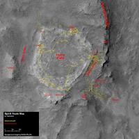
The latest moves were so small that it doesn't deserve an update of the route map, however I thought it was time to double-check the "plots" on the map since Spirit left the winter haven, comparing the navcam mosaics in polar projection with the HiRISE picture. The result is that those moves were overestimated and Spirit's current position is a few meters to the left of where it was previously pointed.
And here's a GE layer too:  Route_Map_Sol1820.kml ( 5.35K )
Number of downloads: 523
Route_Map_Sol1820.kml ( 5.35K )
Number of downloads: 523 |
|
|
|
|
|
 djellison Spirit Route Map Feb 17 2004, 01:07 AM
 Tesheiner I was on a business travel the whole week, with no... Dec 2 2007, 08:58 PM Tesheiner Route map, updated to sol 1392.
Dec 3 2007, 02:55 PM Tesheiner Route map, updated to sol 1394.
Dec 5 2007, 04:17 PM Tesheiner Route map, updated to sol 1396.
Dec 7 2007, 05:56 PM Shaka hmmm... where to now?...Fuzzy Smith? Dec 7 2007, 07:48 PM Floyd Possibly, maybe where they drove up onto Home Plat... Dec 7 2007, 08:19 PM centsworth_II I know Steve Squyres talked about going back to Fu... Dec 7 2007, 09:24 PM ElkGroveDan Nice route map image from the JPL MER site from No... Dec 8 2007, 12:20 AM alan updated to sol 1396
Dec 8 2007, 02:17 AM alan Updated to sol 1397
Dec 8 2007, 10:49 PM Tesheiner Route map, updated to sol 1397.
Dec 9 2007, 08:21 AM climber We're a little bit over 600 m of drive since W... Dec 9 2007, 09:18 AM Tesheiner Route map, updated to sol 1398.
Dec 9 2007, 10:08 PM alan New route map by JPL on HiRISE image in this press... Dec 11 2007, 06:06 AM Tesheiner My version of the route map, updated to sol 1399.
Dec 11 2007, 11:07 AM Tesheiner Sol 1402.
Dec 14 2007, 11:10 AM alan updated to sol 1404
Dec 15 2007, 11:25 PM Tesheiner Route map, updated to sol 1405.
Dec 17 2007, 09:25 AM Tesheiner Yet another update. There are very few changes reg... Feb 18 2008, 09:10 AM
Tesheiner I was on a business travel the whole week, with no... Dec 2 2007, 08:58 PM Tesheiner Route map, updated to sol 1392.
Dec 3 2007, 02:55 PM Tesheiner Route map, updated to sol 1394.
Dec 5 2007, 04:17 PM Tesheiner Route map, updated to sol 1396.
Dec 7 2007, 05:56 PM Shaka hmmm... where to now?...Fuzzy Smith? Dec 7 2007, 07:48 PM Floyd Possibly, maybe where they drove up onto Home Plat... Dec 7 2007, 08:19 PM centsworth_II I know Steve Squyres talked about going back to Fu... Dec 7 2007, 09:24 PM ElkGroveDan Nice route map image from the JPL MER site from No... Dec 8 2007, 12:20 AM alan updated to sol 1396
Dec 8 2007, 02:17 AM alan Updated to sol 1397
Dec 8 2007, 10:49 PM Tesheiner Route map, updated to sol 1397.
Dec 9 2007, 08:21 AM climber We're a little bit over 600 m of drive since W... Dec 9 2007, 09:18 AM Tesheiner Route map, updated to sol 1398.
Dec 9 2007, 10:08 PM alan New route map by JPL on HiRISE image in this press... Dec 11 2007, 06:06 AM Tesheiner My version of the route map, updated to sol 1399.
Dec 11 2007, 11:07 AM Tesheiner Sol 1402.
Dec 14 2007, 11:10 AM alan updated to sol 1404
Dec 15 2007, 11:25 PM Tesheiner Route map, updated to sol 1405.
Dec 17 2007, 09:25 AM Tesheiner Yet another update. There are very few changes reg... Feb 18 2008, 09:10 AM
 Oersted QUOTE (Tesheiner @ Feb 18 2008, 10:10 AM)... Jan 7 2009, 10:31 PM Tesheiner Wow, almost one year since the last map update. ... Jan 7 2009, 05:34 PM Tesheiner Here's a crop of the route map as of sol 1793.... Jan 20 2009, 05:39 PM Tesheiner I removed a bit of "clutter" around the ... Jan 24 2009, 11:43 AM Tesheiner Here's the map updated up to sol 1813. There... Feb 9 2009, 05:33 PM Floyd Tesheiner--As we and now headed toward Van Braun a... Feb 10 2009, 04:45 PM Tesheiner I was almost ready to do it last (martian) summer ... Feb 10 2009, 05:32 PM fredk In the meantime, you can find hirise imagery inclu... Feb 10 2009, 05:59 PM fredk And CosmicRocker made an impressive hirise anaglyp... Feb 10 2009, 07:26 PM CosmicRocker I'm happy to hear that you enjoyed that anagly... Feb 12 2009, 05:52 AM imipak /me raises his hand, somewhat diffidently? (I real... Feb 12 2009, 10:33 PM CosmicRocker Here you go, imipak. It's all yours. Thank y... Feb 14 2009, 07:01 AM Oersted I know this must be asking for far too much, but w... Feb 14 2009, 11:56 AM CosmicRocker Oersted: If I am understanding your request corre... Feb 14 2009, 03:42 PM Oersted Oh, no way I would want anybody to do that manuall... Feb 14 2009, 04:04 PM imipak Magnificent, CR, thanks (and to Eduardo for the ma... Feb 14 2009, 04:13 PM Nirgal QUOTE (imipak @ Feb 14 2009, 05:13 PM) FW... Feb 16 2009, 07:35 PM Tesheiner Here's another map update, corresponding to so... Feb 24 2009, 05:02 PM Tesheiner Map update corresponding to sol 1830.
Feb 26 2009, 10:13 AM Tesheiner Yet another update: sol 1831. Dodging some rocks i... Feb 27 2009, 09:09 PM Tesheiner Sol 1833.
Mar 1 2009, 10:08 PM Tesheiner Here's a crop of the map including Spirit... Mar 4 2009, 02:04 PM Tesheiner Map update up to sol 1839.
Mar 6 2009, 09:36 PM Tesheiner I think it's time to post the whole map again ... Mar 22 2009, 10:33 AM Stu Cripes, looking at the new map (thanks, Tesh) it... Mar 22 2009, 11:58 AM MahFL 20 more drives like that and she'll be there..... Mar 23 2009, 02:24 PM Tesheiner Sol 1856.
Edited: map updated (old route was hi... Mar 24 2009, 12:53 PM Tesheiner Sol 1858. The "interesting" part of the ... Mar 26 2009, 03:00 PM alan Now that Spirit is covering significant ground aga... Mar 28 2009, 05:14 AM Tesheiner Glad to see the aerial view back again!
Here... Mar 29 2009, 10:19 AM alan updated to sol 1861
Mar 29 2009, 07:19 PM Tesheiner Map update for sol 1866.
Apr 3 2009, 08:39 PM Tesheiner Sol 1868.
Apr 5 2009, 08:04 PM alan Updated to sol 1868
Apr 5 2009, 10:52 PM Astro0 Another 'Spirit Route Map' for good measur... Apr 5 2009, 11:35 PM Tesheiner Map update corresponding to sol 1870.
Apr 7 2009, 08:29 PM Astro0 Ground view, best estimate.
EDIT: I think that ... Apr 7 2009, 11:22 PM alan update for sol 1870
Apr 7 2009, 11:36 PM Tesheiner Sol 1871.
Apr 8 2009, 10:13 PM Astro0 Sol1871
Apr 8 2009, 10:55 PM Ant103 Excellent route map Astro0, definitely love it . A... Apr 8 2009, 11:41 PM alan Update for sol 1871
Apr 9 2009, 01:29 AM Tesheiner Here's another map update, still for sol 1871,... Apr 10 2009, 02:28 PM climber Over a year without updating this topic and we kno... Apr 16 2010, 08:27 PM
Oersted QUOTE (Tesheiner @ Feb 18 2008, 10:10 AM)... Jan 7 2009, 10:31 PM Tesheiner Wow, almost one year since the last map update. ... Jan 7 2009, 05:34 PM Tesheiner Here's a crop of the route map as of sol 1793.... Jan 20 2009, 05:39 PM Tesheiner I removed a bit of "clutter" around the ... Jan 24 2009, 11:43 AM Tesheiner Here's the map updated up to sol 1813. There... Feb 9 2009, 05:33 PM Floyd Tesheiner--As we and now headed toward Van Braun a... Feb 10 2009, 04:45 PM Tesheiner I was almost ready to do it last (martian) summer ... Feb 10 2009, 05:32 PM fredk In the meantime, you can find hirise imagery inclu... Feb 10 2009, 05:59 PM fredk And CosmicRocker made an impressive hirise anaglyp... Feb 10 2009, 07:26 PM CosmicRocker I'm happy to hear that you enjoyed that anagly... Feb 12 2009, 05:52 AM imipak /me raises his hand, somewhat diffidently? (I real... Feb 12 2009, 10:33 PM CosmicRocker Here you go, imipak. It's all yours. Thank y... Feb 14 2009, 07:01 AM Oersted I know this must be asking for far too much, but w... Feb 14 2009, 11:56 AM CosmicRocker Oersted: If I am understanding your request corre... Feb 14 2009, 03:42 PM Oersted Oh, no way I would want anybody to do that manuall... Feb 14 2009, 04:04 PM imipak Magnificent, CR, thanks (and to Eduardo for the ma... Feb 14 2009, 04:13 PM Nirgal QUOTE (imipak @ Feb 14 2009, 05:13 PM) FW... Feb 16 2009, 07:35 PM Tesheiner Here's another map update, corresponding to so... Feb 24 2009, 05:02 PM Tesheiner Map update corresponding to sol 1830.
Feb 26 2009, 10:13 AM Tesheiner Yet another update: sol 1831. Dodging some rocks i... Feb 27 2009, 09:09 PM Tesheiner Sol 1833.
Mar 1 2009, 10:08 PM Tesheiner Here's a crop of the map including Spirit... Mar 4 2009, 02:04 PM Tesheiner Map update up to sol 1839.
Mar 6 2009, 09:36 PM Tesheiner I think it's time to post the whole map again ... Mar 22 2009, 10:33 AM Stu Cripes, looking at the new map (thanks, Tesh) it... Mar 22 2009, 11:58 AM MahFL 20 more drives like that and she'll be there..... Mar 23 2009, 02:24 PM Tesheiner Sol 1856.
Edited: map updated (old route was hi... Mar 24 2009, 12:53 PM Tesheiner Sol 1858. The "interesting" part of the ... Mar 26 2009, 03:00 PM alan Now that Spirit is covering significant ground aga... Mar 28 2009, 05:14 AM Tesheiner Glad to see the aerial view back again!
Here... Mar 29 2009, 10:19 AM alan updated to sol 1861
Mar 29 2009, 07:19 PM Tesheiner Map update for sol 1866.
Apr 3 2009, 08:39 PM Tesheiner Sol 1868.
Apr 5 2009, 08:04 PM alan Updated to sol 1868
Apr 5 2009, 10:52 PM Astro0 Another 'Spirit Route Map' for good measur... Apr 5 2009, 11:35 PM Tesheiner Map update corresponding to sol 1870.
Apr 7 2009, 08:29 PM Astro0 Ground view, best estimate.
EDIT: I think that ... Apr 7 2009, 11:22 PM alan update for sol 1870
Apr 7 2009, 11:36 PM Tesheiner Sol 1871.
Apr 8 2009, 10:13 PM Astro0 Sol1871
Apr 8 2009, 10:55 PM Ant103 Excellent route map Astro0, definitely love it . A... Apr 8 2009, 11:41 PM alan Update for sol 1871
Apr 9 2009, 01:29 AM Tesheiner Here's another map update, still for sol 1871,... Apr 10 2009, 02:28 PM climber Over a year without updating this topic and we kno... Apr 16 2010, 08:27 PM |

|
Lo-Fi Version | Time is now: 6th June 2024 - 04:29 PM |
|
RULES AND GUIDELINES Please read the Forum Rules and Guidelines before posting. IMAGE COPYRIGHT |
OPINIONS AND MODERATION Opinions expressed on UnmannedSpaceflight.com are those of the individual posters and do not necessarily reflect the opinions of UnmannedSpaceflight.com or The Planetary Society. The all-volunteer UnmannedSpaceflight.com moderation team is wholly independent of The Planetary Society. The Planetary Society has no influence over decisions made by the UnmannedSpaceflight.com moderators. |
SUPPORT THE FORUM Unmannedspaceflight.com is funded by the Planetary Society. Please consider supporting our work and many other projects by donating to the Society or becoming a member. |
|