Endeavour Drive - Drivability analysis |

Endeavour Drive - Drivability analysis |
 Sep 18 2008, 11:05 AM Sep 18 2008, 11:05 AM
Post
#801
|
|
|
Founder  Group: Chairman Posts: 14433 Joined: 8-February 04 Member No.: 1 |
http://www.sciencefriday.com/program/archives/200809191
You can listen via NPR, or via one of the web feeds that are listed on the site, but make sure you do listen if you can. |
 |
 
|
 |
|
Mar 18 2009, 05:03 AM
Post
#802
|
|||
 Member Group: Members Posts: 236 Joined: 5-June 08 From: Udon Thani Member No.: 4185 |
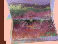
Distribution of Ferric and Iron minerals in Victoria and Endeavour region.
Note the colors in themselves are meaningless, however area's with the same measured quantities of minerals (within a certain bandwidth) are given the same color.
Images are created from the average of 5 different CRISM observations, basically the software checks the quantities for ferric and iron minerals for every position, then creates a mapping giving all positions with the same measured quantities the same color. |
||
|
|
|
||
|
Mar 18 2009, 02:49 PM
Post
#803
|
|
 Senior Member Group: Moderator Posts: 2785 Joined: 10-November 06 From: Pasadena, CA Member No.: 1345 |
QUOTE (Geert @ Mar 18 2009, 12:03 AM)  Distribution of Ferric and Iron minerals in Victoria and Endeavour region. Note the colors in themselves are meaningless, however area's with the same measured quantities of minerals (within a certain bandwidth) are given the same color. This is VERY cool. Would it be possible to add in the topographic data? I think this is creating a pretty geologic map of Meridiani planum with the exposed strata having slightly different mineral components. With the topographic data added, it should be possible to create a side view of the different layers. Here is a previous graphic based on an abstract by Sullivan et al., 2008. (post 731, this thread) The topographic data might also explain the curviness of mineral exposures seen near Endeavour crater seen in your lower graphics. IIRC, as we head south we are going into younger terrain. So each band southward sat above the older northern band in the layer stack. -Mike -------------------- Some higher resolution images available at my photostream: http://www.flickr.com/photos/31678681@N07/
|
|
|
|
|
Mar 18 2009, 04:02 PM
Post
#804
|
|
|
Member Group: Members Posts: 236 Joined: 5-June 08 From: Udon Thani Member No.: 4185 |
QUOTE (Juramike @ Mar 18 2009, 09:49 PM) This is VERY cool. Would it be possible to add in the topographic data? Technically it should be possible, as I mentioned before I developed a dataset with all data (CRISM, HiRISE, THEMIS, etc) in digital format linked to a lat/lon grid, so I can relate anything to anything and project it in any which way and just let the computer crunch out the results (I'm more or less writing the software as I go along). Problem with the topographic data is that as yet I'm not very impressed with MOLA data, I know it's a wonderful tool but at the distance scales we are talking about it's not giving me very much fabric to cling to. Basically the easiest format for me would be a greyscale map-projected 'image' with brightness relating to height but it needs to be very high resolution in order to spot the correlation you're trying to find. An other option might be to simply take a number of lat/lon positions and check their heights in Google-Mars, and from that I can probably let the thing produce a graph relating height to composition... Let's say I'll work on it ;-) With regards to CRISM note that this is all more or less 'raw' data, as has been mentioned before CRISM data is influenced by IR-brightness but it is difficult (for me) to know how much I need to correct for this, it's really nice to see pieces fit together and I love to play with this data and see what I can get out of it, but it's not a proper scientific study ;-). |
|
|
|
 djellison Endeavour Drive - Drivability analysis Sep 18 2008, 11:05 AM
 Geert A first preliminary attempt at 'fingerprint-sc... Feb 7 2009, 05:06 PM Geert Combined view of terrain model and crater-search a... Feb 7 2009, 11:53 PM Geert It has been remarked in this forum already that th... Feb 9 2009, 05:05 PM
 BrianL QUOTE (Geert @ Feb 9 2009, 11:05 AM) It h... Feb 9 2009, 09:02 PM
 Geert QUOTE (BrianL @ Feb 10 2009, 04:02 AM) Ye... Feb 10 2009, 01:29 PM FIN Mars QUOTE (Geert @ Feb 9 2009, 07:05 PM) It h... Feb 14 2009, 08:31 PM Juramike QUOTE (FIN Mars @ Feb 14 2009, 03:31 PM) ... Feb 15 2009, 12:18 AM RobertEB Drive Map
I was looking at the latest map. It loo... Feb 10 2009, 02:53 PM RobertEB QUOTE (Geert @ Feb 9 2009, 12:05 PM) It h... Feb 10 2009, 02:55 PM Geert
Terrain model for Sol 1795, looks like mostly sm... Feb 11 2009, 10:25 AM Geert Terrain model for area south of Sol 1797 position ... Feb 14 2009, 06:32 PM Juramike In the next few days Oppy will get into terrain th... Feb 15 2009, 12:42 AM Geert QUOTE (Juramike @ Feb 15 2009, 07:42 AM) ... Feb 16 2009, 04:16 PM Tesheiner Perhaps Rui/Ustrax is right and we will be heading... Feb 15 2009, 08:03 AM Geert
Terrain-map for sol 1803.
There are a few crate... Feb 19 2009, 12:22 PM Juramike Scorecard for Sol 1786:
For the UMSF Terrain Mod... Feb 22 2009, 04:11 PM Juramike Scorecard for Sol 1791:
For the UMSF Terrain Mode... Feb 22 2009, 04:15 PM Juramike Scorecard for Sol 1793:
For the UMSF Terrain Mode... Feb 22 2009, 04:18 PM Juramike Scorecard for Sol 1795:
For the UMSF Terrain Mode... Feb 22 2009, 04:22 PM Juramike Scorecard for Sol 1796:
For the UMSF Terrain Mode... Feb 22 2009, 04:26 PM Juramike Scorecard for Sol 1797:
For the UMSF Terrain Mod... Mar 6 2009, 12:43 AM Juramike Graph of Sol1784 to Sol1797 observables (as we cru... Mar 6 2009, 12:47 AM Geert Thanks for the Excel sheet, Mike, I'm still bu... Mar 6 2009, 07:33 AM Juramike QUOTE (Geert @ Mar 6 2009, 02:33 AM) Chem... Mar 6 2009, 12:27 PM Geert Same values at same scale as above, now calculated... Mar 6 2009, 07:47 AM Vultur This is (at least) a bit premature, but when we ge... Mar 6 2009, 08:03 AM Geert QUOTE (Vultur @ Mar 6 2009, 03:03 PM) Thi... Mar 6 2009, 09:03 AM Geert Mike, I have been quite busy these last weeks in t... Mar 6 2009, 06:37 PM Geert Distribution of (high-Ca and Low-Ca) pyroxenes in ... Mar 18 2009, 05:11 AM Geert Terrain model created by comparing Mike's meas... Mar 18 2009, 05:21 AM Juramike Here's a graphic based on Geert's CRISM (F... Mar 18 2009, 03:15 PM Geert Further attempt on terrain specification for whole... Mar 23 2009, 06:30 AM Geert Can't resist to post a few more images made wi... Mar 23 2009, 08:01 AM Oersted Your "artwork" is much appreciated Geert... Mar 23 2009, 02:08 PM lyford They do look cool, and they are the right size for... Mar 23 2009, 02:35 PM Geert QUOTE (lyford @ Mar 23 2009, 10:35 PM) I ... Mar 23 2009, 03:19 PM Fran Ontanaya Some terrain South.
Hi res image here (13MB). May 11 2009, 05:09 PM Bobby In the latest Mars Exploration Rover Update at The... Jun 11 2009, 12:40 AM jamescanvin The impression I got was the 'short' path ... Jun 11 2009, 08:11 AM tim53 QUOTE (jamescanvin @ Jun 11 2009, 12:11 A... Jun 12 2009, 04:58 PM Tesheiner I found this one (ESP_011765_1780) via Google Eart... Jun 11 2009, 11:07 AM BrianL You know, I've always suspected that applicati... Jun 11 2009, 05:53 PM Poolio I have to admit I can't see any advantage to g... Jun 11 2009, 06:52 PM BrianL
OK, here's my lame attempt at the route I en... Jun 11 2009, 08:58 PM Poolio Thanks for posting that, BrianL. Crude though it ... Jun 12 2009, 05:45 PM BrianL My suggested path is certainly very roughly plotte... Jun 12 2009, 07:40 PM SFJCody I've created a couple of kml files showing whe... Jun 14 2009, 05:15 AM antoniseb Nice map!
Why not go another km or so South ... Jun 14 2009, 10:06 AM SpaceListener Techniques to advance:
On Bedrock : Maybe it would... Jun 14 2009, 06:52 PM SFJCody QUOTE (antoniseb @ Jun 14 2009, 11:06 AM)... Jun 14 2009, 11:27 PM BrianL Wow, I can see Oppy high-tailing as she bounds thr... Jun 15 2009, 03:30 AM centsworth_II QUOTE (BrianL @ Jun 14 2009, 10:30 PM) Wo... Jun 15 2009, 06:33 AM SFJCody I finished the map extension on Monday but have on... Jun 19 2009, 03:53 AM jamescanvin QUOTE (SFJCody @ Jun 19 2009, 04:53 AM) A... Jun 19 2009, 07:48 AM Tesheiner Just thinking out loud but it would be great to ha... Jun 26 2009, 10:05 PM SFJCody QUOTE (jamescanvin @ Jun 19 2009, 08:48 A... Jun 27 2009, 06:42 AM SFJCody QUOTE (Tesheiner @ Jun 26 2009, 11:05 PM)... Jun 27 2009, 07:49 AM SFJCody QUOTE (Tesheiner @ Jun 26 2009, 11:05 PM)... Jun 28 2009, 09:01 AM jamescanvin I'll see what I can do - babies take up a lot ... Jun 27 2009, 10:39 AM jamescanvin PM sent to SFJCody with the tiles. If anyone else ... Jun 27 2009, 05:10 PM Tesheiner Actually, you can keep both options.
The BIG amou... Jun 28 2009, 09:16 PM SFJCody QUOTE (Tesheiner @ Jun 28 2009, 10:16 PM)... Jun 28 2009, 09:22 PM SFJCody Version 2 preview, not at full resolution. I'm... Jul 6 2009, 08:11 PM SFJCody Well, I've finally decided to upload version 2... Sep 27 2009, 08:10 AM djellison Thanks for the torrent - it's coming down now,... Sep 27 2009, 04:46 PM Tesheiner Thanks too!
It takes a bit of time loading on ... Sep 27 2009, 08:44 PM SFJCody QUOTE (Tesheiner @ Sep 27 2009, 09:44 PM)... Sep 27 2009, 09:07 PM Tesheiner QUOTE (SFJCody @ Sep 27 2009, 11:07 PM) H... Sep 27 2009, 09:55 PM
Geert QUOTE (BrianL @ Feb 10 2009, 04:02 AM) Ye... Feb 10 2009, 01:29 PM FIN Mars QUOTE (Geert @ Feb 9 2009, 07:05 PM) It h... Feb 14 2009, 08:31 PM Juramike QUOTE (FIN Mars @ Feb 14 2009, 03:31 PM) ... Feb 15 2009, 12:18 AM RobertEB Drive Map
I was looking at the latest map. It loo... Feb 10 2009, 02:53 PM RobertEB QUOTE (Geert @ Feb 9 2009, 12:05 PM) It h... Feb 10 2009, 02:55 PM Geert
Terrain model for Sol 1795, looks like mostly sm... Feb 11 2009, 10:25 AM Geert Terrain model for area south of Sol 1797 position ... Feb 14 2009, 06:32 PM Juramike In the next few days Oppy will get into terrain th... Feb 15 2009, 12:42 AM Geert QUOTE (Juramike @ Feb 15 2009, 07:42 AM) ... Feb 16 2009, 04:16 PM Tesheiner Perhaps Rui/Ustrax is right and we will be heading... Feb 15 2009, 08:03 AM Geert
Terrain-map for sol 1803.
There are a few crate... Feb 19 2009, 12:22 PM Juramike Scorecard for Sol 1786:
For the UMSF Terrain Mod... Feb 22 2009, 04:11 PM Juramike Scorecard for Sol 1791:
For the UMSF Terrain Mode... Feb 22 2009, 04:15 PM Juramike Scorecard for Sol 1793:
For the UMSF Terrain Mode... Feb 22 2009, 04:18 PM Juramike Scorecard for Sol 1795:
For the UMSF Terrain Mode... Feb 22 2009, 04:22 PM Juramike Scorecard for Sol 1796:
For the UMSF Terrain Mode... Feb 22 2009, 04:26 PM Juramike Scorecard for Sol 1797:
For the UMSF Terrain Mod... Mar 6 2009, 12:43 AM Juramike Graph of Sol1784 to Sol1797 observables (as we cru... Mar 6 2009, 12:47 AM Geert Thanks for the Excel sheet, Mike, I'm still bu... Mar 6 2009, 07:33 AM Juramike QUOTE (Geert @ Mar 6 2009, 02:33 AM) Chem... Mar 6 2009, 12:27 PM Geert Same values at same scale as above, now calculated... Mar 6 2009, 07:47 AM Vultur This is (at least) a bit premature, but when we ge... Mar 6 2009, 08:03 AM Geert QUOTE (Vultur @ Mar 6 2009, 03:03 PM) Thi... Mar 6 2009, 09:03 AM Geert Mike, I have been quite busy these last weeks in t... Mar 6 2009, 06:37 PM Geert Distribution of (high-Ca and Low-Ca) pyroxenes in ... Mar 18 2009, 05:11 AM Geert Terrain model created by comparing Mike's meas... Mar 18 2009, 05:21 AM Juramike Here's a graphic based on Geert's CRISM (F... Mar 18 2009, 03:15 PM Geert Further attempt on terrain specification for whole... Mar 23 2009, 06:30 AM Geert Can't resist to post a few more images made wi... Mar 23 2009, 08:01 AM Oersted Your "artwork" is much appreciated Geert... Mar 23 2009, 02:08 PM lyford They do look cool, and they are the right size for... Mar 23 2009, 02:35 PM Geert QUOTE (lyford @ Mar 23 2009, 10:35 PM) I ... Mar 23 2009, 03:19 PM Fran Ontanaya Some terrain South.
Hi res image here (13MB). May 11 2009, 05:09 PM Bobby In the latest Mars Exploration Rover Update at The... Jun 11 2009, 12:40 AM jamescanvin The impression I got was the 'short' path ... Jun 11 2009, 08:11 AM tim53 QUOTE (jamescanvin @ Jun 11 2009, 12:11 A... Jun 12 2009, 04:58 PM Tesheiner I found this one (ESP_011765_1780) via Google Eart... Jun 11 2009, 11:07 AM BrianL You know, I've always suspected that applicati... Jun 11 2009, 05:53 PM Poolio I have to admit I can't see any advantage to g... Jun 11 2009, 06:52 PM BrianL
OK, here's my lame attempt at the route I en... Jun 11 2009, 08:58 PM Poolio Thanks for posting that, BrianL. Crude though it ... Jun 12 2009, 05:45 PM BrianL My suggested path is certainly very roughly plotte... Jun 12 2009, 07:40 PM SFJCody I've created a couple of kml files showing whe... Jun 14 2009, 05:15 AM antoniseb Nice map!
Why not go another km or so South ... Jun 14 2009, 10:06 AM SpaceListener Techniques to advance:
On Bedrock : Maybe it would... Jun 14 2009, 06:52 PM SFJCody QUOTE (antoniseb @ Jun 14 2009, 11:06 AM)... Jun 14 2009, 11:27 PM BrianL Wow, I can see Oppy high-tailing as she bounds thr... Jun 15 2009, 03:30 AM centsworth_II QUOTE (BrianL @ Jun 14 2009, 10:30 PM) Wo... Jun 15 2009, 06:33 AM SFJCody I finished the map extension on Monday but have on... Jun 19 2009, 03:53 AM jamescanvin QUOTE (SFJCody @ Jun 19 2009, 04:53 AM) A... Jun 19 2009, 07:48 AM Tesheiner Just thinking out loud but it would be great to ha... Jun 26 2009, 10:05 PM SFJCody QUOTE (jamescanvin @ Jun 19 2009, 08:48 A... Jun 27 2009, 06:42 AM SFJCody QUOTE (Tesheiner @ Jun 26 2009, 11:05 PM)... Jun 27 2009, 07:49 AM SFJCody QUOTE (Tesheiner @ Jun 26 2009, 11:05 PM)... Jun 28 2009, 09:01 AM jamescanvin I'll see what I can do - babies take up a lot ... Jun 27 2009, 10:39 AM jamescanvin PM sent to SFJCody with the tiles. If anyone else ... Jun 27 2009, 05:10 PM Tesheiner Actually, you can keep both options.
The BIG amou... Jun 28 2009, 09:16 PM SFJCody QUOTE (Tesheiner @ Jun 28 2009, 10:16 PM)... Jun 28 2009, 09:22 PM SFJCody Version 2 preview, not at full resolution. I'm... Jul 6 2009, 08:11 PM SFJCody Well, I've finally decided to upload version 2... Sep 27 2009, 08:10 AM djellison Thanks for the torrent - it's coming down now,... Sep 27 2009, 04:46 PM Tesheiner Thanks too!
It takes a bit of time loading on ... Sep 27 2009, 08:44 PM SFJCody QUOTE (Tesheiner @ Sep 27 2009, 09:44 PM)... Sep 27 2009, 09:07 PM Tesheiner QUOTE (SFJCody @ Sep 27 2009, 11:07 PM) H... Sep 27 2009, 09:55 PM |

|
Lo-Fi Version | Time is now: 6th June 2024 - 03:05 AM |
|
RULES AND GUIDELINES Please read the Forum Rules and Guidelines before posting. IMAGE COPYRIGHT |
OPINIONS AND MODERATION Opinions expressed on UnmannedSpaceflight.com are those of the individual posters and do not necessarily reflect the opinions of UnmannedSpaceflight.com or The Planetary Society. The all-volunteer UnmannedSpaceflight.com moderation team is wholly independent of The Planetary Society. The Planetary Society has no influence over decisions made by the UnmannedSpaceflight.com moderators. |
SUPPORT THE FORUM Unmannedspaceflight.com is funded by the Planetary Society. Please consider supporting our work and many other projects by donating to the Society or becoming a member. |
|