Titan's topography, strange.... |

Titan's topography, strange.... |
 Apr 12 2009, 12:44 PM Apr 12 2009, 12:44 PM
Post
#1
|
|
 Senior Member  Group: Moderator Posts: 2785 Joined: 10-November 06 From: Pasadena, CA Member No.: 1345 |
Recent article in Science by Zebker et al.:
Zebker et al. Science in press, "Size and Shape of Saturn's Moon Titan". doi: 10.1126/science.1168905 (published online April 2, 2009) Link to abstract (pay-for article): http://www.sciencemag.org/cgi/content/abstract/1168905 Article on spaceref discusses this paper: http://www.spaceref.com/news/viewpr.html?pid=27912 Figure 3 from the Science article is a global elevation map relative to barycenter. Key points of article:
"Xanadu seems to be systematically lower than other parts of the equatorial belt, and not uplifted like most mountainous areas on Earth." (quote from Fig. 3 caption in article) -Mike -------------------- Some higher resolution images available at my photostream: http://www.flickr.com/photos/31678681@N07/
|
 |
 
|
 |
|
Apr 12 2009, 03:46 PM
Post
#2
|
||||
|
Senior Member Group: Moderator Posts: 2785 Joined: 10-November 06 From: Pasadena, CA Member No.: 1345 |
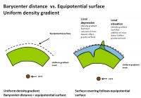
The Science article is in reference to the Barycentric center of Titan.
This could be different from the equipotential surface. If I understand this correctly.... In a perfect world, with a uniform density gradient, the elevation and equipotential surfaces pretty much match:
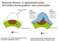
A large mass concentration (high density crustal materials) can cause a localized gravity well, and cause the equipotential surface to bulge out. (More mass, more gravity, more "pull"). So you can get an elevated ocean that covers a elevated (based on barycenter distance) rise.
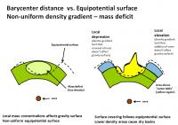
A mass deficit (lower density crustal materials) can cause a localized gravity deficit and cause the equipotential surface to dip in. (less mass, less gravity, less "pull"). This could cause a basin that one would think should be flooded, to be dry. The water table responds to the equipotential surface, not the elevation.
http://en.wikipedia.org/wiki/Geoid -------------------- Some higher resolution images available at my photostream: http://www.flickr.com/photos/31678681@N07/
|
|||
|
|
|
|||
 Juramike Titan's topography Apr 12 2009, 12:44 PM
 Juramike Here's a cartooon showing how Xanadu could hav... Apr 12 2009, 03:32 PM Juramike So now a Big Question:
Why are the poles wet, the ... Apr 12 2009, 04:00 PM ngunn Thanks for starting off a discussion on this. One ... Apr 12 2009, 08:24 PM
Juramike Here's a cartooon showing how Xanadu could hav... Apr 12 2009, 03:32 PM Juramike So now a Big Question:
Why are the poles wet, the ... Apr 12 2009, 04:00 PM ngunn Thanks for starting off a discussion on this. One ... Apr 12 2009, 08:24 PM
 rlorenz QUOTE (ngunn @ Apr 12 2009, 04:24 PM) Tha... Apr 15 2009, 03:39 AM Doc Forgive my ignorance ngunn but exactly what was th... Apr 12 2009, 08:44 PM rlorenz QUOTE (Doc @ Apr 12 2009, 04:44 PM) Forgi... Apr 15 2009, 03:31 AM ngunn It came from RADAR reflectance observations of the... Apr 12 2009, 09:03 PM Juramike Nigel's right, the most recent evidence comes ... Apr 13 2009, 01:45 AM Juramike The channel drainage pattern in W Xanadu in the T1... Apr 13 2009, 02:07 AM ngunn On the ellipsoid vs. equipotential I'm happy t... Apr 15 2009, 09:34 AM Juramike Looking at channels in the RADAR Swaths, I haven... Apr 15 2009, 02:34 PM ngunn QUOTE (Juramike @ Apr 15 2009, 03:34 PM) ... Apr 15 2009, 03:06 PM Juramike QUOTE (rlorenz @ Apr 14 2009, 10:39 PM) T... Apr 15 2009, 03:18 PM ngunn Correct me if I'm wrong (again), but aren... Apr 15 2009, 03:44 PM Juramike If I understand this correctly, the dunes line up ... Apr 15 2009, 05:10 PM Juramike Two different wind regimes, but with one component... Apr 15 2009, 05:32 PM ngunn Mike I'm having trouble reconciling what you d... Apr 15 2009, 06:06 PM Juramike The maps show the linear dune orientation. The li... Apr 15 2009, 07:17 PM ngunn QUOTE (Juramike @ Apr 15 2009, 08:17 PM) ... Apr 15 2009, 07:36 PM Juramike If I remember correctly, the GCM wind field change... Apr 15 2009, 09:40 PM ngunn I'm just reading the transcript of the Titan s... Apr 15 2009, 09:59 PM Juramike From looking at RADAR images, it looks like the W ... Apr 16 2009, 02:45 AM ngunn QUOTE (Juramike @ Apr 16 2009, 03:45 AM) ... Apr 16 2009, 08:50 AM Juramike Bingo!
Tokano, T. Icarus 194 (2008) 243-262. ... Apr 16 2009, 02:46 AM ngunn A further thought on albedo-controlled winds. Sinc... Apr 16 2009, 10:01 AM ngunn Let's take this even further into the realm of... Apr 16 2009, 10:32 AM Juramike It also means that Xanadu, and processes that oper... Apr 16 2009, 11:31 AM ngunn Possibly, but it also restores - or rather preserv... Apr 16 2009, 11:38 AM Juramike QUOTE (ngunn @ Apr 16 2009, 06:38 AM) Pos... Apr 16 2009, 07:47 PM ngunn QUOTE (Juramike @ Apr 16 2009, 08:47 PM) ... Apr 16 2009, 09:52 PM Jason W Barnes QUOTE (ngunn @ Apr 16 2009, 04:38 AM) Pos... Apr 21 2009, 12:50 AM Jason W Barnes QUOTE (Jason W Barnes @ Apr 20 2009, 05:5... Apr 21 2009, 12:51 AM ngunn This thread has gone very quiet! In the meanti... Apr 20 2009, 11:07 AM ngunn A poem:
- - -
The Walrus and the Carpenter
Were w... Apr 20 2009, 02:10 PM Phil Stooke What's an order of magnitude among friends?
P... Apr 21 2009, 02:44 AM Juramike If Xanadu is "self-clearing" then the du... Apr 21 2009, 03:06 AM ngunn QUOTE (Juramike @ Apr 21 2009, 04:06 AM) ... Apr 21 2009, 08:06 AM ngunn I've just peformed an experiment which crudely... Apr 21 2009, 03:36 PM helvick Very nice work there ngunn - I was struggling to f... Apr 21 2009, 04:39 PM Jason W Barnes QUOTE (ngunn @ Apr 21 2009, 08:36 AM) I... Apr 22 2009, 07:45 PM stevesliva QUOTE (Jason W Barnes @ Apr 22 2009, 03:4... Apr 22 2009, 08:43 PM Jason W Barnes QUOTE (stevesliva @ Apr 22 2009, 01:43 PM... Apr 24 2009, 12:39 AM stevesliva QUOTE (Jason W Barnes @ Apr 23 2009, 08:3... Apr 24 2009, 02:27 PM ngunn QUOTE (Jason W Barnes @ Apr 22 2009, 08:4... Apr 22 2009, 09:37 PM ngunn Glad you liked it. Did you listen to the Takemitsu... Apr 21 2009, 09:54 PM ngunn After sleeping on it I'll now try to be more e... Apr 23 2009, 08:01 AM DFortes "No disrespect," to quote Jon Stewart, b... Apr 24 2009, 03:53 PM Juramike Link for Dorset, Acta Crystallographica B51 (1995)... Apr 24 2009, 06:40 PM Juramike Stiles et al. Icarus (2009) ASAP. "Determini... Apr 24 2009, 07:41 PM ngunn A stray thought on the dust-into-sand coagulation ... Apr 24 2009, 08:25 PM DFortes On the crystalline versus amorphous debate
There ... Apr 24 2009, 10:50 PM Juramike Good points.
F.M Flasar and R.K Achterberg, Phil.... Apr 24 2009, 11:55 PM Jason W Barnes QUOTE (Juramike @ Apr 24 2009, 04:55 PM) ... Apr 27 2009, 06:41 PM stevesliva QUOTE (Jason W Barnes @ Apr 27 2009, 02:4... Apr 27 2009, 09:39 PM ngunn The paper is in the current issue of 'Science... May 15 2009, 08:58 AM titanicrivers Wow such an incredible discussion ! It is tim... Sep 26 2009, 09:33 AM ngunn Brilliant, TR! I think that needs doing for a... Sep 26 2009, 09:44 AM titanicrivers QUOTE (ngunn @ Sep 26 2009, 04:44 AM) Bri... Sep 27 2009, 03:38 AM titanicrivers Here's a modified SARTopo map for Adiri and th... Sep 30 2009, 11:34 PM titanicrivers Here's a modified SARTopo map of the Huygens l... Sep 30 2009, 11:41 PM titanicrivers QUOTE (titanicrivers @ Sep 30 2009, 06:41... Oct 4 2009, 05:17 PM Juramike The "spooky dude" feature still puzzles ... Oct 4 2009, 06:00 PM ngunn Mike, I noticed that you had implied this in one o... Oct 4 2009, 07:15 PM titanicrivers I would also wonder if catastrophic flow was runni... Oct 4 2009, 07:58 PM ngunn Against that suggestion I would note that these ov... Oct 4 2009, 08:31 PM titanicrivers QUOTE (ngunn @ Oct 4 2009, 03:31 PM) Agai... Oct 6 2009, 08:20 PM Juramike Elevation shows the spooky dude formation is eleva... Oct 5 2009, 12:14 AM titanicrivers QUOTE (Juramike @ Oct 4 2009, 07:14 PM) E... Oct 5 2009, 01:49 AM ngunn QUOTE (Juramike @ Oct 5 2009, 01:14 AM) E... Oct 5 2009, 06:12 AM ngunn Interesting comparisons there for sure. I'd li... Oct 6 2009, 09:03 PM Juramike This oval feature shown above is part of the ... Oct 7 2009, 12:34 AM Juramike Graphic showing elevation trace (based only on th... Oct 7 2009, 01:11 AM ngunn Right! Got my position wrong, but the argument... Oct 7 2009, 07:28 AM titanicrivers QUOTE (ngunn @ Oct 7 2009, 02:28 AM) Righ... Oct 11 2009, 10:35 PM ngunn That's great: I so much prefer a sequence of s... Oct 11 2009, 11:10 PM Decepticon titanicrivers WOW! Oct 12 2009, 12:43 AM Juramike Nice overlay TR!
I'm not sure if the Spoo... Oct 12 2009, 02:35 AM titanicrivers The recent http://photojournal.jpl.nasa.gov/target... Aug 25 2010, 02:02 AM Juramike Interesting how the channels go to the north into ... Aug 25 2010, 02:28 AM titanicrivers QUOTE (Juramike @ Aug 24 2010, 08:28 PM) ... Aug 25 2010, 07:08 AM Bill Harris TR--
Nifty topography. Reminds me of an uplifted... Aug 25 2010, 04:17 PM Decepticon ^ I tried to do the cross eyed thing and my result... Aug 26 2010, 02:21 AM titanicrivers I found this article via Wikipedia that may help y... Aug 26 2010, 08:51 AM titanicrivers Here is another 2D to 3D image that is relatively ... Sep 1 2010, 05:43 AM titanicrivers N00153307-9 composite with 2D to 3D conversion and... Sep 7 2010, 06:27 AM titanicrivers N Aaru Mountains, Titan. T16 SAR swath Part2, edi... Sep 10 2010, 08:31 AM titanicrivers Things are a little slow with Titan at the moment... Dec 6 2010, 06:56 PM algorimancer QUOTE (titanicrivers @ Dec 6 2010, 12:56 ... Dec 7 2010, 01:59 PM titanicrivers Agree the horizontal ridge is not compatible with ... Dec 11 2010, 07:46 AM AndyG My head's not wired to do cross-eyed 3d images... Dec 11 2010, 09:09 AM Juramike Yeah, my head's not wired for side by side vie... Dec 11 2010, 02:37 PM titanicrivers Here's a favorite spot on Titan for many of us... Feb 27 2011, 07:47 AM algorimancer Very subtle topography in this one.
Incidentally... Feb 28 2011, 04:11 PM titanicrivers T8 SAR part 2 contains lots of interesting topogra... May 9 2011, 05:13 AM titanicrivers The recent Photojournal image http://photojournal.... Jan 6 2013, 05:58 AM Ron Hobbs I just saw this on the JPL web site:
Cassini Sugg... Jan 8 2013, 07:33 PM stevesliva I bet there's some fantastic small-scale topog... Jan 8 2013, 10:45 PM Ron Hobbs Yeah, my mind is quivering with possibilities.
Ma... Jan 9 2013, 04:02 AM
rlorenz QUOTE (ngunn @ Apr 12 2009, 04:24 PM) Tha... Apr 15 2009, 03:39 AM Doc Forgive my ignorance ngunn but exactly what was th... Apr 12 2009, 08:44 PM rlorenz QUOTE (Doc @ Apr 12 2009, 04:44 PM) Forgi... Apr 15 2009, 03:31 AM ngunn It came from RADAR reflectance observations of the... Apr 12 2009, 09:03 PM Juramike Nigel's right, the most recent evidence comes ... Apr 13 2009, 01:45 AM Juramike The channel drainage pattern in W Xanadu in the T1... Apr 13 2009, 02:07 AM ngunn On the ellipsoid vs. equipotential I'm happy t... Apr 15 2009, 09:34 AM Juramike Looking at channels in the RADAR Swaths, I haven... Apr 15 2009, 02:34 PM ngunn QUOTE (Juramike @ Apr 15 2009, 03:34 PM) ... Apr 15 2009, 03:06 PM Juramike QUOTE (rlorenz @ Apr 14 2009, 10:39 PM) T... Apr 15 2009, 03:18 PM ngunn Correct me if I'm wrong (again), but aren... Apr 15 2009, 03:44 PM Juramike If I understand this correctly, the dunes line up ... Apr 15 2009, 05:10 PM Juramike Two different wind regimes, but with one component... Apr 15 2009, 05:32 PM ngunn Mike I'm having trouble reconciling what you d... Apr 15 2009, 06:06 PM Juramike The maps show the linear dune orientation. The li... Apr 15 2009, 07:17 PM ngunn QUOTE (Juramike @ Apr 15 2009, 08:17 PM) ... Apr 15 2009, 07:36 PM Juramike If I remember correctly, the GCM wind field change... Apr 15 2009, 09:40 PM ngunn I'm just reading the transcript of the Titan s... Apr 15 2009, 09:59 PM Juramike From looking at RADAR images, it looks like the W ... Apr 16 2009, 02:45 AM ngunn QUOTE (Juramike @ Apr 16 2009, 03:45 AM) ... Apr 16 2009, 08:50 AM Juramike Bingo!
Tokano, T. Icarus 194 (2008) 243-262. ... Apr 16 2009, 02:46 AM ngunn A further thought on albedo-controlled winds. Sinc... Apr 16 2009, 10:01 AM ngunn Let's take this even further into the realm of... Apr 16 2009, 10:32 AM Juramike It also means that Xanadu, and processes that oper... Apr 16 2009, 11:31 AM ngunn Possibly, but it also restores - or rather preserv... Apr 16 2009, 11:38 AM Juramike QUOTE (ngunn @ Apr 16 2009, 06:38 AM) Pos... Apr 16 2009, 07:47 PM ngunn QUOTE (Juramike @ Apr 16 2009, 08:47 PM) ... Apr 16 2009, 09:52 PM Jason W Barnes QUOTE (ngunn @ Apr 16 2009, 04:38 AM) Pos... Apr 21 2009, 12:50 AM Jason W Barnes QUOTE (Jason W Barnes @ Apr 20 2009, 05:5... Apr 21 2009, 12:51 AM ngunn This thread has gone very quiet! In the meanti... Apr 20 2009, 11:07 AM ngunn A poem:
- - -
The Walrus and the Carpenter
Were w... Apr 20 2009, 02:10 PM Phil Stooke What's an order of magnitude among friends?
P... Apr 21 2009, 02:44 AM Juramike If Xanadu is "self-clearing" then the du... Apr 21 2009, 03:06 AM ngunn QUOTE (Juramike @ Apr 21 2009, 04:06 AM) ... Apr 21 2009, 08:06 AM ngunn I've just peformed an experiment which crudely... Apr 21 2009, 03:36 PM helvick Very nice work there ngunn - I was struggling to f... Apr 21 2009, 04:39 PM Jason W Barnes QUOTE (ngunn @ Apr 21 2009, 08:36 AM) I... Apr 22 2009, 07:45 PM stevesliva QUOTE (Jason W Barnes @ Apr 22 2009, 03:4... Apr 22 2009, 08:43 PM Jason W Barnes QUOTE (stevesliva @ Apr 22 2009, 01:43 PM... Apr 24 2009, 12:39 AM stevesliva QUOTE (Jason W Barnes @ Apr 23 2009, 08:3... Apr 24 2009, 02:27 PM ngunn QUOTE (Jason W Barnes @ Apr 22 2009, 08:4... Apr 22 2009, 09:37 PM ngunn Glad you liked it. Did you listen to the Takemitsu... Apr 21 2009, 09:54 PM ngunn After sleeping on it I'll now try to be more e... Apr 23 2009, 08:01 AM DFortes "No disrespect," to quote Jon Stewart, b... Apr 24 2009, 03:53 PM Juramike Link for Dorset, Acta Crystallographica B51 (1995)... Apr 24 2009, 06:40 PM Juramike Stiles et al. Icarus (2009) ASAP. "Determini... Apr 24 2009, 07:41 PM ngunn A stray thought on the dust-into-sand coagulation ... Apr 24 2009, 08:25 PM DFortes On the crystalline versus amorphous debate
There ... Apr 24 2009, 10:50 PM Juramike Good points.
F.M Flasar and R.K Achterberg, Phil.... Apr 24 2009, 11:55 PM Jason W Barnes QUOTE (Juramike @ Apr 24 2009, 04:55 PM) ... Apr 27 2009, 06:41 PM stevesliva QUOTE (Jason W Barnes @ Apr 27 2009, 02:4... Apr 27 2009, 09:39 PM ngunn The paper is in the current issue of 'Science... May 15 2009, 08:58 AM titanicrivers Wow such an incredible discussion ! It is tim... Sep 26 2009, 09:33 AM ngunn Brilliant, TR! I think that needs doing for a... Sep 26 2009, 09:44 AM titanicrivers QUOTE (ngunn @ Sep 26 2009, 04:44 AM) Bri... Sep 27 2009, 03:38 AM titanicrivers Here's a modified SARTopo map for Adiri and th... Sep 30 2009, 11:34 PM titanicrivers Here's a modified SARTopo map of the Huygens l... Sep 30 2009, 11:41 PM titanicrivers QUOTE (titanicrivers @ Sep 30 2009, 06:41... Oct 4 2009, 05:17 PM Juramike The "spooky dude" feature still puzzles ... Oct 4 2009, 06:00 PM ngunn Mike, I noticed that you had implied this in one o... Oct 4 2009, 07:15 PM titanicrivers I would also wonder if catastrophic flow was runni... Oct 4 2009, 07:58 PM ngunn Against that suggestion I would note that these ov... Oct 4 2009, 08:31 PM titanicrivers QUOTE (ngunn @ Oct 4 2009, 03:31 PM) Agai... Oct 6 2009, 08:20 PM Juramike Elevation shows the spooky dude formation is eleva... Oct 5 2009, 12:14 AM titanicrivers QUOTE (Juramike @ Oct 4 2009, 07:14 PM) E... Oct 5 2009, 01:49 AM ngunn QUOTE (Juramike @ Oct 5 2009, 01:14 AM) E... Oct 5 2009, 06:12 AM ngunn Interesting comparisons there for sure. I'd li... Oct 6 2009, 09:03 PM Juramike This oval feature shown above is part of the ... Oct 7 2009, 12:34 AM Juramike Graphic showing elevation trace (based only on th... Oct 7 2009, 01:11 AM ngunn Right! Got my position wrong, but the argument... Oct 7 2009, 07:28 AM titanicrivers QUOTE (ngunn @ Oct 7 2009, 02:28 AM) Righ... Oct 11 2009, 10:35 PM ngunn That's great: I so much prefer a sequence of s... Oct 11 2009, 11:10 PM Decepticon titanicrivers WOW! Oct 12 2009, 12:43 AM Juramike Nice overlay TR!
I'm not sure if the Spoo... Oct 12 2009, 02:35 AM titanicrivers The recent http://photojournal.jpl.nasa.gov/target... Aug 25 2010, 02:02 AM Juramike Interesting how the channels go to the north into ... Aug 25 2010, 02:28 AM titanicrivers QUOTE (Juramike @ Aug 24 2010, 08:28 PM) ... Aug 25 2010, 07:08 AM Bill Harris TR--
Nifty topography. Reminds me of an uplifted... Aug 25 2010, 04:17 PM Decepticon ^ I tried to do the cross eyed thing and my result... Aug 26 2010, 02:21 AM titanicrivers I found this article via Wikipedia that may help y... Aug 26 2010, 08:51 AM titanicrivers Here is another 2D to 3D image that is relatively ... Sep 1 2010, 05:43 AM titanicrivers N00153307-9 composite with 2D to 3D conversion and... Sep 7 2010, 06:27 AM titanicrivers N Aaru Mountains, Titan. T16 SAR swath Part2, edi... Sep 10 2010, 08:31 AM titanicrivers Things are a little slow with Titan at the moment... Dec 6 2010, 06:56 PM algorimancer QUOTE (titanicrivers @ Dec 6 2010, 12:56 ... Dec 7 2010, 01:59 PM titanicrivers Agree the horizontal ridge is not compatible with ... Dec 11 2010, 07:46 AM AndyG My head's not wired to do cross-eyed 3d images... Dec 11 2010, 09:09 AM Juramike Yeah, my head's not wired for side by side vie... Dec 11 2010, 02:37 PM titanicrivers Here's a favorite spot on Titan for many of us... Feb 27 2011, 07:47 AM algorimancer Very subtle topography in this one.
Incidentally... Feb 28 2011, 04:11 PM titanicrivers T8 SAR part 2 contains lots of interesting topogra... May 9 2011, 05:13 AM titanicrivers The recent Photojournal image http://photojournal.... Jan 6 2013, 05:58 AM Ron Hobbs I just saw this on the JPL web site:
Cassini Sugg... Jan 8 2013, 07:33 PM stevesliva I bet there's some fantastic small-scale topog... Jan 8 2013, 10:45 PM Ron Hobbs Yeah, my mind is quivering with possibilities.
Ma... Jan 9 2013, 04:02 AM |

|
Lo-Fi Version | Time is now: 27th September 2024 - 07:53 AM |
|
RULES AND GUIDELINES Please read the Forum Rules and Guidelines before posting. IMAGE COPYRIGHT |
OPINIONS AND MODERATION Opinions expressed on UnmannedSpaceflight.com are those of the individual posters and do not necessarily reflect the opinions of UnmannedSpaceflight.com or The Planetary Society. The all-volunteer UnmannedSpaceflight.com moderation team is wholly independent of The Planetary Society. The Planetary Society has no influence over decisions made by the UnmannedSpaceflight.com moderators. |
SUPPORT THE FORUM Unmannedspaceflight.com is funded by the Planetary Society. Please consider supporting our work and many other projects by donating to the Society or becoming a member. |
|