Virtual Viking, Images and animations of the Viking landing sites |

Virtual Viking, Images and animations of the Viking landing sites |
 Sep 4 2008, 02:29 PM Sep 4 2008, 02:29 PM
Post
#1
|
||
|
Solar System Cartographer  Group: Members Posts: 10229 Joined: 5-April 05 From: Canada Member No.: 227 |
In the past we've had some good Viking images here. Soon - all too soon - we will not have Phoenix any more, but despair not! Now we can re-live Viking by playing with old images. They can be searched by sol at the PDS.
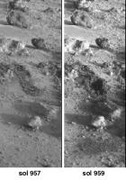
As an example, I've made a composite of the very last Surface Sampler activities at either Viking site. This is work done on Viking 2 sol 957 and imaged on sol 957 and 959. (someone can animate it if they like!) We see two separate trenching activities at the same place, and a soil dump (bottom) and a conical soil pile made by the second dump (middle). (more obvious in an animation, I just can't make one on this machine). Phil
-------------------- ... because the Solar System ain't gonna map itself.
Also to be found posting similar content on https://mastodon.social/@PhilStooke Maps for download (free PDF: https://upload.wikimedia.org/wikipedia/comm...Cartography.pdf NOTE: everything created by me which I post on UMSF is considered to be in the public domain (NOT CC, public domain) |
|
 |
 
|
|
 |
|
May 23 2009, 03:46 AM
Post
#2
|
||
|
Solar System Cartographer Group: Members Posts: 10229 Joined: 5-April 05 From: Canada Member No.: 227 |
Another of the things we can do so much better now than in the old days...
The Vikings carried mirrors on the sampler arm, and one of them could be viewed by one of the cameras to see underneath the lander. Seven images of the mirror were taken by Viking 1 on sols 528, 550, 582 and 594. They can be combined to produce a mosaic of the area underneath Engine 2 (the one right under the cameras) to look at the erosion effects of the engine during landing. The version made during Viking times was really bad! But now we can do it much better. This image contains two separate mosaics - they are supposed to fit together, but right now I don't have the old mosaic with me to compare and figure it out. They have been reversed to take the reflection into account and enlarged 2x. The bottom mosaic shows an erosion pit where loose soil has been blown away to reveal harder crusty stuff underneath. (EDIT: I found the location and fixed the mosaic) Phil
-------------------- ... because the Solar System ain't gonna map itself.
Also to be found posting similar content on https://mastodon.social/@PhilStooke Maps for download (free PDF: https://upload.wikimedia.org/wikipedia/comm...Cartography.pdf NOTE: everything created by me which I post on UMSF is considered to be in the public domain (NOT CC, public domain) |
|
|
|
|
|
 Phil Stooke Virtual Viking Sep 4 2008, 02:29 PM
 imipak Attempt at an animation - not terribly good I... Sep 4 2008, 06:47 PM PhilCo126 Great idea Phil... that will bring back some child... Sep 5 2008, 11:15 AM Phil Stooke This is a set of four images documenting that last... Sep 5 2008, 01:13 PM
 tedstryk Ricardo Nunes and I worked together on some images... Sep 5 2008, 10:27 PM Phil Stooke Here's a bit more Virtual Viking - reliving th... Oct 13 2008, 07:21 PM Phil Stooke ... and here's the left side of the Viking 1 w... Oct 13 2008, 08:23 PM lyford Thanks Phil these are quite nice.... Oct 13 2008, 11:40 PM Phil Stooke I have just edited post 4 above - and replaced its... Oct 14 2008, 03:08 AM Phil Stooke ... and the left side...
Phil
Oct 14 2008, 03:10 AM Phil Stooke Here's another digging sequence from Viking 2.... Oct 14 2008, 03:59 AM PhilCo126 Nice work, reading " A Passion for Mars ... Nov 15 2008, 02:41 PM Phil Stooke Here's a pic from Viking:
It's the full... Nov 18 2008, 01:30 AM tedstryk Wow...I don't think I have ever seen those tog... Nov 18 2008, 03:56 AM PhilCo126 The goldmine(s) for Viking Lander images:
Lander ... Nov 22 2008, 02:19 PM tedstryk QUOTE (PhilCo126 @ Nov 22 2008, 02:19 PM)... Nov 23 2008, 03:07 AM PhilCo126 Does one need a password to access the Planetary D... Nov 23 2008, 12:56 PM djellison No.
http://pds-geosciences.wustl.edu/geo/vl1_v...... Nov 23 2008, 05:08 PM Phil Stooke I prefer this source, from which images can be sel... Nov 23 2008, 05:16 PM Phil Stooke The Viking 1 site mapped in a new way... This is ... Apr 21 2009, 02:23 PM Phil Stooke I'm still perfecting that reprojected Viking 1... May 11 2009, 07:30 PM Phil Stooke Here's the Viking 2 mosaic underneath Engine 2... May 23 2009, 10:59 PM lyford Those are truly special, Phil! May 24 2009, 01:30 AM nprev They are indeed! I'm gonna start saving... May 24 2009, 01:54 AM Phil Stooke I have edited my post above with the Viking 1 mirr... May 26 2009, 01:58 AM Phil Stooke Another bit of Viking history now we are all think... May 28 2009, 09:07 PM vikingmars QUOTE (Phil Stooke @ May 28 2009, 10:07 P... May 29 2009, 10:19 AM nprev Fascinating (not a word I use lightly), Phil; did ... May 29 2009, 12:23 AM Phil Stooke There's a lot of good stuff in those committee... May 29 2009, 01:16 AM Phil Stooke A good panorama for Viking 2 is hard to find. I h... Jun 16 2009, 06:37 PM scalbers QUOTE (Phil Stooke @ Jun 16 2009, 06:37 P... Jul 13 2009, 09:30 PM scalbers QUOTE (scalbers @ Jul 13 2009, 09:30 PM) ... Nov 15 2009, 09:17 PM nprev Everytime I look at the Viking sites I still marve... Jun 16 2009, 07:41 PM Phil Stooke The tilt was already corrected for in the assemble... Jun 16 2009, 08:22 PM Stu Gorgeous pic Phil, great work as usual. I could - ... Jun 16 2009, 09:49 PM Phil Stooke Here's the Viking 2 pan wrapped into a circle ... Jun 17 2009, 03:26 PM mhoward Awesome job on both. Jun 17 2009, 04:10 PM tedstryk Amazing! Jun 26 2009, 03:08 PM Phil Stooke Thanks! I am doing some improvements to the p... Jun 27 2009, 12:40 AM SpaceListener Unique scenary. Surface is very rocky. That leads ... Jun 27 2009, 05:08 AM vikingmars As a tribute to Phil's gorgeous work, here is ... Jun 29 2009, 09:02 PM vikingmars ...and now for VL1 (especially made to show to the... Jun 29 2009, 09:16 PM nprev Those were AWESOME, VM, thanks!!!
Nev... Jun 30 2009, 02:25 AM SpaceListener Spectaculars pictures. The VL2 landing is terrific... Jun 30 2009, 02:58 AM climber Merci Olivier... the quality of the panos is absol... Jun 30 2009, 09:26 AM Phil Stooke Speaking of Viking... next week I'm at Brown U... Jul 1 2009, 03:46 AM nprev Ooo...gotta be some good stuff in there, Phil, hap... Jul 1 2009, 05:01 AM Phil Stooke OK, back from Providence with lots of goodies.
Np... Jul 13 2009, 08:38 PM nprev Welcome back, and thanks for checking that out, Ph... Jul 13 2009, 11:48 PM Phil Stooke My current plan is to submit the manuscript at the... Jul 14 2009, 12:12 PM Phil Stooke Here's a little goodie from my visit to Brown ... Aug 10 2009, 01:14 AM machi Viking 2 lander site in years 1976 and 1978. Nov 9 2009, 05:23 PM machi "High speed" panorama from Viking 1. Its... Nov 9 2009, 05:40 PM machi Morning on Mars from Viking 2 lander. First image ... Nov 10 2009, 03:31 PM scalbers ...and the same for camera 2.
As a reminder I h... Nov 15 2009, 09:29 PM Stu scalbers, Machi - just fantastic work, guys, genui... Nov 15 2009, 11:19 PM scalbers Stu - one "modern" thing I've long ... Nov 16 2009, 01:09 AM 4th rock from the sun QUOTE (scalbers @ Nov 16 2009, 02:09 AM) ... Nov 16 2009, 10:51 AM Phil Stooke All these ideas are very good - and exactly what I... Nov 16 2009, 03:54 AM scalbers Yes I can appreciate the hi-res color mosaics migh... Nov 21 2009, 02:41 PM Phil Stooke Can anyone help me with this? I'm trying to f... Jan 21 2010, 06:34 PM elakdawalla Sorting the CUMINDEX.TAB file for Viking Orbiter o... Jan 21 2010, 06:38 PM Phil Stooke That was quick! Thanks very much. Yes, very ... Jan 21 2010, 07:00 PM Phil Stooke Just to follow up, that number may not include som... Jan 21 2010, 07:07 PM elakdawalla It includes the following:
547 VO1 images targeted... Jan 21 2010, 07:36 PM Phil Stooke Thanks again!
Phil Jan 21 2010, 07:51 PM Phil Stooke This is an image that, as far as I know, has never... Jan 28 2010, 06:21 PM vikingmars QUOTE (Phil Stooke @ Jan 28 2010, 07:21 P... Jan 30 2010, 12:05 AM lyford Very cool - I have been transported in time AND sp... Jan 28 2010, 07:37 PM vikingmars ...And by the way, phil : you did a GREAT work ... Jan 30 2010, 12:07 AM JohnVV i would say that the temp sencer is this ( in red ... Jan 30 2010, 09:03 AM Phil Stooke Here is the comparable mosaic of images of the foo... Jun 1 2010, 03:51 PM Vanden Hello,
Thank you all, especially those that proce... Dec 11 2010, 04:18 PM ElkGroveDan QUOTE (Vanden @ Dec 11 2010, 08:18 AM) no... Dec 11 2010, 04:25 PM Vanden QUOTE (ElkGroveDan @ Dec 11 2010, 05:25 P... Dec 11 2010, 04:35 PM Vanden And here a portion of the assembly :
Dec 13 2010, 01:09 AM scalbers QUOTE (Vanden @ Dec 13 2010, 01:09 AM) An... Jan 15 2011, 11:45 PM vikingmars QUOTE (Vanden @ Dec 13 2010, 02:09 AM) An... Jan 17 2011, 05:21 AM nprev Beautiful. Thanks!
Always love looking at Big... Dec 13 2010, 01:14 AM Phil Stooke Not his cap but the drift at his base!
Phil Dec 13 2010, 03:42 AM nprev Was it? I always thought that a piece of the cap f... Dec 13 2010, 04:13 AM Phil Stooke The only visible change was at the base, no change... Dec 13 2010, 05:01 AM nprev Oh, I believe you, man; love to see the pics! ... Dec 13 2010, 06:17 AM ElkGroveDan QUOTE (nprev @ Dec 12 2010, 10:17 PM) (ac... Dec 13 2010, 08:08 AM Phil Stooke Viking 1 saw a second similar change later, as wel... Dec 13 2010, 12:13 PM Phil Stooke Here are the two Viking 1 changes with a little bi... Dec 13 2010, 02:43 PM Phil Stooke I should add that the Viking Lander imagery is rip... Dec 13 2010, 08:42 PM nprev Awesome. I forgot all about the Whale slump.
Than... Dec 14 2010, 01:49 AM Phil Stooke Here's another comparison image showing change... Jan 13 2011, 06:03 PM Stu That's fascinating Phil, thanks. I honestly wa... Jan 13 2011, 06:22 PM vikingmars ...And another one, done using the same techniques... Jan 17 2011, 08:49 PM eoincampbell Tremendous, I really dig that last one...
... th... Jan 18 2011, 01:43 AM Vanden Thank you for these images and explanations.
I lik... Feb 23 2011, 12:10 AM vikingmars QUOTE (Vanden @ Feb 23 2011, 01:10 AM) ..... Feb 26 2011, 09:25 PM Oersted Wauw! to that complete panorama, new desktop... Feb 23 2011, 09:35 AM machi Finally full size, high-res, color panorama from V... Feb 23 2011, 11:15 AM Phil Stooke A little experiment. This is a super-resolution c... Jul 7 2011, 05:55 PM ElkGroveDan Wow. That is sharp. Jul 7 2011, 06:28 PM vikingmars When I processed and built the Curiosity dusk pano... Feb 23 2013, 09:09 PM
tedstryk Ricardo Nunes and I worked together on some images... Sep 5 2008, 10:27 PM Phil Stooke Here's a bit more Virtual Viking - reliving th... Oct 13 2008, 07:21 PM Phil Stooke ... and here's the left side of the Viking 1 w... Oct 13 2008, 08:23 PM lyford Thanks Phil these are quite nice.... Oct 13 2008, 11:40 PM Phil Stooke I have just edited post 4 above - and replaced its... Oct 14 2008, 03:08 AM Phil Stooke ... and the left side...
Phil
Oct 14 2008, 03:10 AM Phil Stooke Here's another digging sequence from Viking 2.... Oct 14 2008, 03:59 AM PhilCo126 Nice work, reading " A Passion for Mars ... Nov 15 2008, 02:41 PM Phil Stooke Here's a pic from Viking:
It's the full... Nov 18 2008, 01:30 AM tedstryk Wow...I don't think I have ever seen those tog... Nov 18 2008, 03:56 AM PhilCo126 The goldmine(s) for Viking Lander images:
Lander ... Nov 22 2008, 02:19 PM tedstryk QUOTE (PhilCo126 @ Nov 22 2008, 02:19 PM)... Nov 23 2008, 03:07 AM PhilCo126 Does one need a password to access the Planetary D... Nov 23 2008, 12:56 PM djellison No.
http://pds-geosciences.wustl.edu/geo/vl1_v...... Nov 23 2008, 05:08 PM Phil Stooke I prefer this source, from which images can be sel... Nov 23 2008, 05:16 PM Phil Stooke The Viking 1 site mapped in a new way... This is ... Apr 21 2009, 02:23 PM Phil Stooke I'm still perfecting that reprojected Viking 1... May 11 2009, 07:30 PM Phil Stooke Here's the Viking 2 mosaic underneath Engine 2... May 23 2009, 10:59 PM lyford Those are truly special, Phil! May 24 2009, 01:30 AM nprev They are indeed! I'm gonna start saving... May 24 2009, 01:54 AM Phil Stooke I have edited my post above with the Viking 1 mirr... May 26 2009, 01:58 AM Phil Stooke Another bit of Viking history now we are all think... May 28 2009, 09:07 PM vikingmars QUOTE (Phil Stooke @ May 28 2009, 10:07 P... May 29 2009, 10:19 AM nprev Fascinating (not a word I use lightly), Phil; did ... May 29 2009, 12:23 AM Phil Stooke There's a lot of good stuff in those committee... May 29 2009, 01:16 AM Phil Stooke A good panorama for Viking 2 is hard to find. I h... Jun 16 2009, 06:37 PM scalbers QUOTE (Phil Stooke @ Jun 16 2009, 06:37 P... Jul 13 2009, 09:30 PM scalbers QUOTE (scalbers @ Jul 13 2009, 09:30 PM) ... Nov 15 2009, 09:17 PM nprev Everytime I look at the Viking sites I still marve... Jun 16 2009, 07:41 PM Phil Stooke The tilt was already corrected for in the assemble... Jun 16 2009, 08:22 PM Stu Gorgeous pic Phil, great work as usual. I could - ... Jun 16 2009, 09:49 PM Phil Stooke Here's the Viking 2 pan wrapped into a circle ... Jun 17 2009, 03:26 PM mhoward Awesome job on both. Jun 17 2009, 04:10 PM tedstryk Amazing! Jun 26 2009, 03:08 PM Phil Stooke Thanks! I am doing some improvements to the p... Jun 27 2009, 12:40 AM SpaceListener Unique scenary. Surface is very rocky. That leads ... Jun 27 2009, 05:08 AM vikingmars As a tribute to Phil's gorgeous work, here is ... Jun 29 2009, 09:02 PM vikingmars ...and now for VL1 (especially made to show to the... Jun 29 2009, 09:16 PM nprev Those were AWESOME, VM, thanks!!!
Nev... Jun 30 2009, 02:25 AM SpaceListener Spectaculars pictures. The VL2 landing is terrific... Jun 30 2009, 02:58 AM climber Merci Olivier... the quality of the panos is absol... Jun 30 2009, 09:26 AM Phil Stooke Speaking of Viking... next week I'm at Brown U... Jul 1 2009, 03:46 AM nprev Ooo...gotta be some good stuff in there, Phil, hap... Jul 1 2009, 05:01 AM Phil Stooke OK, back from Providence with lots of goodies.
Np... Jul 13 2009, 08:38 PM nprev Welcome back, and thanks for checking that out, Ph... Jul 13 2009, 11:48 PM Phil Stooke My current plan is to submit the manuscript at the... Jul 14 2009, 12:12 PM Phil Stooke Here's a little goodie from my visit to Brown ... Aug 10 2009, 01:14 AM machi Viking 2 lander site in years 1976 and 1978. Nov 9 2009, 05:23 PM machi "High speed" panorama from Viking 1. Its... Nov 9 2009, 05:40 PM machi Morning on Mars from Viking 2 lander. First image ... Nov 10 2009, 03:31 PM scalbers ...and the same for camera 2.
As a reminder I h... Nov 15 2009, 09:29 PM Stu scalbers, Machi - just fantastic work, guys, genui... Nov 15 2009, 11:19 PM scalbers Stu - one "modern" thing I've long ... Nov 16 2009, 01:09 AM 4th rock from the sun QUOTE (scalbers @ Nov 16 2009, 02:09 AM) ... Nov 16 2009, 10:51 AM Phil Stooke All these ideas are very good - and exactly what I... Nov 16 2009, 03:54 AM scalbers Yes I can appreciate the hi-res color mosaics migh... Nov 21 2009, 02:41 PM Phil Stooke Can anyone help me with this? I'm trying to f... Jan 21 2010, 06:34 PM elakdawalla Sorting the CUMINDEX.TAB file for Viking Orbiter o... Jan 21 2010, 06:38 PM Phil Stooke That was quick! Thanks very much. Yes, very ... Jan 21 2010, 07:00 PM Phil Stooke Just to follow up, that number may not include som... Jan 21 2010, 07:07 PM elakdawalla It includes the following:
547 VO1 images targeted... Jan 21 2010, 07:36 PM Phil Stooke Thanks again!
Phil Jan 21 2010, 07:51 PM Phil Stooke This is an image that, as far as I know, has never... Jan 28 2010, 06:21 PM vikingmars QUOTE (Phil Stooke @ Jan 28 2010, 07:21 P... Jan 30 2010, 12:05 AM lyford Very cool - I have been transported in time AND sp... Jan 28 2010, 07:37 PM vikingmars ...And by the way, phil : you did a GREAT work ... Jan 30 2010, 12:07 AM JohnVV i would say that the temp sencer is this ( in red ... Jan 30 2010, 09:03 AM Phil Stooke Here is the comparable mosaic of images of the foo... Jun 1 2010, 03:51 PM Vanden Hello,
Thank you all, especially those that proce... Dec 11 2010, 04:18 PM ElkGroveDan QUOTE (Vanden @ Dec 11 2010, 08:18 AM) no... Dec 11 2010, 04:25 PM Vanden QUOTE (ElkGroveDan @ Dec 11 2010, 05:25 P... Dec 11 2010, 04:35 PM Vanden And here a portion of the assembly :
Dec 13 2010, 01:09 AM scalbers QUOTE (Vanden @ Dec 13 2010, 01:09 AM) An... Jan 15 2011, 11:45 PM vikingmars QUOTE (Vanden @ Dec 13 2010, 02:09 AM) An... Jan 17 2011, 05:21 AM nprev Beautiful. Thanks!
Always love looking at Big... Dec 13 2010, 01:14 AM Phil Stooke Not his cap but the drift at his base!
Phil Dec 13 2010, 03:42 AM nprev Was it? I always thought that a piece of the cap f... Dec 13 2010, 04:13 AM Phil Stooke The only visible change was at the base, no change... Dec 13 2010, 05:01 AM nprev Oh, I believe you, man; love to see the pics! ... Dec 13 2010, 06:17 AM ElkGroveDan QUOTE (nprev @ Dec 12 2010, 10:17 PM) (ac... Dec 13 2010, 08:08 AM Phil Stooke Viking 1 saw a second similar change later, as wel... Dec 13 2010, 12:13 PM Phil Stooke Here are the two Viking 1 changes with a little bi... Dec 13 2010, 02:43 PM Phil Stooke I should add that the Viking Lander imagery is rip... Dec 13 2010, 08:42 PM nprev Awesome. I forgot all about the Whale slump.
Than... Dec 14 2010, 01:49 AM Phil Stooke Here's another comparison image showing change... Jan 13 2011, 06:03 PM Stu That's fascinating Phil, thanks. I honestly wa... Jan 13 2011, 06:22 PM vikingmars ...And another one, done using the same techniques... Jan 17 2011, 08:49 PM eoincampbell Tremendous, I really dig that last one...
... th... Jan 18 2011, 01:43 AM Vanden Thank you for these images and explanations.
I lik... Feb 23 2011, 12:10 AM vikingmars QUOTE (Vanden @ Feb 23 2011, 01:10 AM) ..... Feb 26 2011, 09:25 PM Oersted Wauw! to that complete panorama, new desktop... Feb 23 2011, 09:35 AM machi Finally full size, high-res, color panorama from V... Feb 23 2011, 11:15 AM Phil Stooke A little experiment. This is a super-resolution c... Jul 7 2011, 05:55 PM ElkGroveDan Wow. That is sharp. Jul 7 2011, 06:28 PM vikingmars When I processed and built the Curiosity dusk pano... Feb 23 2013, 09:09 PM |

|
Lo-Fi Version | Time is now: 26th September 2024 - 11:49 AM |
|
RULES AND GUIDELINES Please read the Forum Rules and Guidelines before posting. IMAGE COPYRIGHT |
OPINIONS AND MODERATION Opinions expressed on UnmannedSpaceflight.com are those of the individual posters and do not necessarily reflect the opinions of UnmannedSpaceflight.com or The Planetary Society. The all-volunteer UnmannedSpaceflight.com moderation team is wholly independent of The Planetary Society. The Planetary Society has no influence over decisions made by the UnmannedSpaceflight.com moderators. |
SUPPORT THE FORUM Unmannedspaceflight.com is funded by the Planetary Society. Please consider supporting our work and many other projects by donating to the Society or becoming a member. |
|