The western route, 5th leg after stop at Absecon / Reeds Bay |

The western route, 5th leg after stop at Absecon / Reeds Bay |
 Jul 11 2009, 05:57 PM Jul 11 2009, 05:57 PM
Post
#1
|
||
|
Senior Member  Group: Moderator Posts: 4279 Joined: 19-April 05 From: .br at .es Member No.: 253 |
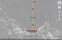
Time for a new thread.
After moving southwards for ages, the "detour" by the western path has started with a 60+ meters drive on sol 1942.
There are no images yet --they should be available on the next update-- so this image was calculated solely based on the rover's mobility info. I'll update the route map later. |
|
 |
 
|
|
 |
|
Jul 20 2009, 05:12 PM
Post
#2
|
|
|
Senior Member Group: Moderator Posts: 4279 Joined: 19-April 05 From: .br at .es Member No.: 253 |
There was an "albedo pan" taken during sol 1949 but I don't know if it's already downlinked or not. We should try locating the cape in those pancams; the heading is... (checking in Google Mars) ... 16 degrees CW.
And speaking again about the mini-craters, the one to the left is "Dolphin". |
|
|
|
 Tesheiner The western route Jul 11 2009, 05:57 PM
 Marz QUOTE (Tesheiner @ Jul 11 2009, 11:57 AM)... Jul 12 2009, 03:03 AM
 jamescanvin QUOTE (Marz @ Jul 12 2009, 04:03 AM) Is t... Jul 12 2009, 08:46 AM MarkG So, on this last leg to the Martian west, across m... Jul 12 2009, 05:18 AM Nirgal QUOTE (MarkG @ Jul 12 2009, 07:18 AM) So,... Jul 13 2009, 05:32 PM BrianL I thought we would have had a revised TraxMap (tm)... Jul 12 2009, 03:34 PM ustrax QUOTE (BrianL @ Jul 12 2009, 04:34 PM) I ... Jul 13 2009, 08:49 AM Astro0 Ustrax: "...not in the direction I expected..... Jul 13 2009, 11:52 AM BrianL I meant really revised, Rui. What's your take ... Jul 13 2009, 01:21 PM ustrax QUOTE (BrianL @ Jul 13 2009, 02:21 PM) I ... Jul 13 2009, 02:24 PM alan nice view
Jul 13 2009, 04:36 PM Stu You just beat me to it, Alan. You're right, fa... Jul 13 2009, 05:49 PM BrianL <clink> <clink>
What are those hills ... Jul 13 2009, 06:21 PM ustrax QUOTE (BrianL @ Jul 13 2009, 07:21 PM) ... Jul 13 2009, 06:29 PM fredk Thanks for the heads up, guys, these are great vie... Jul 13 2009, 06:52 PM ustrax Fred, if that's Iazu, let's wrap this Ende... Jul 13 2009, 07:00 PM jamescanvin Fred's right that is Iazu again - great view.
... Jul 13 2009, 07:35 PM Tesheiner Wow, what a view!
I saw that sequence (Iazu... Jul 13 2009, 08:20 PM ustrax James, sorry for asking but, that's not all Ia... Jul 13 2009, 08:25 PM fredk QUOTE (ustrax @ Jul 13 2009, 09:25 PM) th... Jul 13 2009, 09:29 PM Stu Craig Covault - speaking live on SpaceflightNow... Jul 13 2009, 08:39 PM dvandorn Stu, my understanding is that the "clays... Jul 14 2009, 02:00 AM CosmicRocker Yeah. When Endeavour became the goal, I perused t... Jul 14 2009, 05:59 AM Tesheiner Today was another driving sol, where almost 70m we... Jul 15 2009, 08:57 PM CosmicRocker I realized that I should have better referenced th... Jul 16 2009, 05:54 AM climber I while ago somebody wrote, I think it was Phil, t... Jul 16 2009, 08:31 AM ElkGroveDan QUOTE (climber @ Jul 16 2009, 01:31 AM) Y... Jul 16 2009, 02:12 PM climber QUOTE (ElkGroveDan @ Jul 16 2009, 04:12 P... Jul 16 2009, 03:38 PM Zeke4ther Ahhh....a touch of Canadian content... Jul 16 2009, 09:24 PM Phil Stooke Can't have too much of that.
Phil Jul 16 2009, 09:47 PM dot.dk Some good news in the latest update
http://mar... Jul 19 2009, 12:47 PM ustrax Hey, are these marks left my Oppy's wheels? I ... Jul 19 2009, 09:17 PM Fran Ontanaya She has done that before. The bedrock isn't ve... Jul 19 2009, 11:02 PM Tesheiner Check the navcams taken during sol 1950: http://qt... Jul 20 2009, 06:35 AM fredk QUOTE (Tesheiner @ Jul 20 2009, 07:35 AM)... Jul 24 2009, 03:53 AM Tesheiner QUOTE (fredk @ Jul 24 2009, 05:53 AM) Cou... Jul 24 2009, 08:18 AM Stu Not sure which crater this is... taken my eye off ... Jul 20 2009, 11:48 AM Tesheiner That's Alvin. Here's a navcam mosaic made ... Jul 20 2009, 04:26 PM fredk I've been watching Cape St. Mary (Beacon) in ... Jul 20 2009, 05:00 PM Stu
Others will do better, I'm sure. I just fanc... Jul 21 2009, 02:36 PM Stu ... and t'other one...
Jul 21 2009, 02:38 PM dvandorn Hmmm... how much of what looks like good flat pave... Jul 22 2009, 01:18 AM glennwsmith Stu, very nice job on the small meteor craters. C... Jul 22 2009, 03:30 AM serpens QUOTE (glennwsmith @ Jul 22 2009, 03:30 A... Jul 23 2009, 02:50 AM Tesheiner I just checked the info from yestersol drive (1952... Jul 22 2009, 11:10 AM alan Going back for closer look at this perhaps?
From ... Jul 22 2009, 11:38 AM Sunspot QUOTE (alan @ Jul 22 2009, 12:38 PM) Goin... Jul 22 2009, 07:06 PM SFJCody Great news! This will take me more time to t... Jul 22 2009, 07:44 PM Julius What should we call that!?looks quite big to m... Jul 22 2009, 01:27 PM Tesheiner It was named "Block Island".
01946::p25... Jul 22 2009, 01:48 PM Floyd Tesheiner, would it be possible put a label for Bl... Jul 22 2009, 03:03 PM tim53 QUOTE (Floyd @ Jul 22 2009, 07:03 AM) Tes... Jul 22 2009, 06:21 PM fredk "Block Island" is actually a ways south ... Jul 22 2009, 03:17 PM BrianL Or this is a repeat of that programming glitch tha... Jul 22 2009, 03:45 PM Tesheiner No way that it would be another instance of the ... Jul 22 2009, 05:02 PM Julius So now we're sailing in the north atlantic alo... Jul 22 2009, 05:04 PM fredk I estimate Block Island is roughly 25 cm tall by 5... Jul 22 2009, 07:04 PM Reckless Hi FredK
Here's a crop of the region I think y... Jul 22 2009, 08:01 PM tim53 Roy:
It's in there!
-Tim. Jul 22 2009, 08:25 PM HughFromAlice Would someone who can see where it is please circl... Jul 22 2009, 09:22 PM tim53 QUOTE (HughFromAlice @ Jul 22 2009, 01:22... Jul 22 2009, 09:35 PM SFJCody Wow, that's a long drive back. Whatever it is ... Jul 22 2009, 09:50 PM djellison I can well understand why we're going to have ... Jul 22 2009, 09:46 PM Tesheiner Thanks for pointing the rock Tim.
Added it to the... Jul 22 2009, 10:22 PM Drkskywxlt Can someone summarize the reasons their taking the... Jul 23 2009, 12:28 AM nprev Hmm. Well, as Doug pointed out, BI is an anomaly i... Jul 23 2009, 12:48 AM ElkGroveDan QUOTE (nprev @ Jul 22 2009, 04:48 PM) Tim... Jul 23 2009, 01:06 AM fredk QUOTE (ElkGroveDan @ Jul 23 2009, 02:06 A... Jul 23 2009, 01:22 AM serpens QUOTE (fredk @ Jul 23 2009, 01:22 AM) No.... Jul 23 2009, 01:28 AM fredk QUOTE (serpens @ Jul 23 2009, 02:28 AM) S... Jul 24 2009, 12:12 AM glennwsmith Serpens, thanks for the link to the crater diamete... Jul 23 2009, 03:26 AM tim53 Doug has it. It's the biggest thing not assoc... Jul 23 2009, 04:19 AM nprev Certainly reason enough. And there I was, spinning... Jul 23 2009, 05:04 AM glennwsmith Alan, my man! What led you to this felicitous... Jul 23 2009, 05:06 AM alan Just thought 'hey that looks interesting' ... Jul 23 2009, 05:36 AM CosmicRocker QUOTE (tim53 @ Jul 22 2009, 11:19 PM) Dou... Jul 23 2009, 06:47 AM centsworth_II QUOTE (CosmicRocker @ Jul 23 2009, 01:47 ... Jul 23 2009, 04:20 PM fredk QUOTE (centsworth_II @ Jul 23 2009, 05:20... Jul 23 2009, 05:41 PM Burmese But what took the team so long to decide to turn a... Jul 23 2009, 03:01 PM fredk QUOTE (Burmese @ Jul 23 2009, 04:01 PM) B... Jul 23 2009, 03:14 PM fredk Thanks for the maps, guys. I now measure the dist... Jul 23 2009, 03:04 PM alan QUOTE (fredk @ Jul 23 2009, 10:04 AM) Do ... Jul 23 2009, 04:15 PM centsworth_II QUOTE (fredk @ Jul 23 2009, 10:04 AM) Do ... Jul 23 2009, 04:24 PM serpens QUOTE (fredk @ Jul 23 2009, 04:04 PM) Do ... Jul 23 2009, 11:21 PM CosmicRocker QUOTE (centsworth_II @ Jul 23 2009, 10:20... Jul 24 2009, 04:15 AM glennwsmith Drksywxlt, yes, the rovers have been sent on some ... Jul 24 2009, 04:24 AM climber QUOTE (glennwsmith @ Jul 24 2009, 06:24 A... Jul 24 2009, 07:25 AM djellison I guess in the category of 'turn back to go so... Jul 24 2009, 07:01 AM Tesheiner Another interesting note in the latest status repo... Jul 24 2009, 09:55 AM Phil Stooke The crater namers forgot that they had already use... Jul 24 2009, 11:00 AM Tesheiner Thanks for the info, Phil.
Time for another map u... Jul 24 2009, 11:10 AM Tesheiner Here's our target "Block Island" in ... Jul 27 2009, 01:24 PM SFJCody Two foreign forms on a sand ribbed plain
One low ... Jul 27 2009, 04:38 PM Stu Land - well, something interesting - ho..!
Jul 27 2009, 04:46 PM BrianL At this distance and angle, my mind is turning tha... Jul 27 2009, 08:36 PM Bobby What are those Crab Fishermen from The Deadliest C... Jul 27 2009, 08:56 PM glennwsmith SFJCody, your poem is clever and elegant. It call... Jul 27 2009, 10:56 PM Enceladus75 The latest traverse map looks puzzling. Does thi... Jul 28 2009, 02:25 AM centsworth_II QUOTE (Enceladus75 @ Jul 27 2009, 09:25 P... Jul 28 2009, 03:13 AM
jamescanvin QUOTE (Marz @ Jul 12 2009, 04:03 AM) Is t... Jul 12 2009, 08:46 AM MarkG So, on this last leg to the Martian west, across m... Jul 12 2009, 05:18 AM Nirgal QUOTE (MarkG @ Jul 12 2009, 07:18 AM) So,... Jul 13 2009, 05:32 PM BrianL I thought we would have had a revised TraxMap (tm)... Jul 12 2009, 03:34 PM ustrax QUOTE (BrianL @ Jul 12 2009, 04:34 PM) I ... Jul 13 2009, 08:49 AM Astro0 Ustrax: "...not in the direction I expected..... Jul 13 2009, 11:52 AM BrianL I meant really revised, Rui. What's your take ... Jul 13 2009, 01:21 PM ustrax QUOTE (BrianL @ Jul 13 2009, 02:21 PM) I ... Jul 13 2009, 02:24 PM alan nice view
Jul 13 2009, 04:36 PM Stu You just beat me to it, Alan. You're right, fa... Jul 13 2009, 05:49 PM BrianL <clink> <clink>
What are those hills ... Jul 13 2009, 06:21 PM ustrax QUOTE (BrianL @ Jul 13 2009, 07:21 PM) ... Jul 13 2009, 06:29 PM fredk Thanks for the heads up, guys, these are great vie... Jul 13 2009, 06:52 PM ustrax Fred, if that's Iazu, let's wrap this Ende... Jul 13 2009, 07:00 PM jamescanvin Fred's right that is Iazu again - great view.
... Jul 13 2009, 07:35 PM Tesheiner Wow, what a view!
I saw that sequence (Iazu... Jul 13 2009, 08:20 PM ustrax James, sorry for asking but, that's not all Ia... Jul 13 2009, 08:25 PM fredk QUOTE (ustrax @ Jul 13 2009, 09:25 PM) th... Jul 13 2009, 09:29 PM Stu Craig Covault - speaking live on SpaceflightNow... Jul 13 2009, 08:39 PM dvandorn Stu, my understanding is that the "clays... Jul 14 2009, 02:00 AM CosmicRocker Yeah. When Endeavour became the goal, I perused t... Jul 14 2009, 05:59 AM Tesheiner Today was another driving sol, where almost 70m we... Jul 15 2009, 08:57 PM CosmicRocker I realized that I should have better referenced th... Jul 16 2009, 05:54 AM climber I while ago somebody wrote, I think it was Phil, t... Jul 16 2009, 08:31 AM ElkGroveDan QUOTE (climber @ Jul 16 2009, 01:31 AM) Y... Jul 16 2009, 02:12 PM climber QUOTE (ElkGroveDan @ Jul 16 2009, 04:12 P... Jul 16 2009, 03:38 PM Zeke4ther Ahhh....a touch of Canadian content... Jul 16 2009, 09:24 PM Phil Stooke Can't have too much of that.
Phil Jul 16 2009, 09:47 PM dot.dk Some good news in the latest update
http://mar... Jul 19 2009, 12:47 PM ustrax Hey, are these marks left my Oppy's wheels? I ... Jul 19 2009, 09:17 PM Fran Ontanaya She has done that before. The bedrock isn't ve... Jul 19 2009, 11:02 PM Tesheiner Check the navcams taken during sol 1950: http://qt... Jul 20 2009, 06:35 AM fredk QUOTE (Tesheiner @ Jul 20 2009, 07:35 AM)... Jul 24 2009, 03:53 AM Tesheiner QUOTE (fredk @ Jul 24 2009, 05:53 AM) Cou... Jul 24 2009, 08:18 AM Stu Not sure which crater this is... taken my eye off ... Jul 20 2009, 11:48 AM Tesheiner That's Alvin. Here's a navcam mosaic made ... Jul 20 2009, 04:26 PM fredk I've been watching Cape St. Mary (Beacon) in ... Jul 20 2009, 05:00 PM Stu
Others will do better, I'm sure. I just fanc... Jul 21 2009, 02:36 PM Stu ... and t'other one...
Jul 21 2009, 02:38 PM dvandorn Hmmm... how much of what looks like good flat pave... Jul 22 2009, 01:18 AM glennwsmith Stu, very nice job on the small meteor craters. C... Jul 22 2009, 03:30 AM serpens QUOTE (glennwsmith @ Jul 22 2009, 03:30 A... Jul 23 2009, 02:50 AM Tesheiner I just checked the info from yestersol drive (1952... Jul 22 2009, 11:10 AM alan Going back for closer look at this perhaps?
From ... Jul 22 2009, 11:38 AM Sunspot QUOTE (alan @ Jul 22 2009, 12:38 PM) Goin... Jul 22 2009, 07:06 PM SFJCody Great news! This will take me more time to t... Jul 22 2009, 07:44 PM Julius What should we call that!?looks quite big to m... Jul 22 2009, 01:27 PM Tesheiner It was named "Block Island".
01946::p25... Jul 22 2009, 01:48 PM Floyd Tesheiner, would it be possible put a label for Bl... Jul 22 2009, 03:03 PM tim53 QUOTE (Floyd @ Jul 22 2009, 07:03 AM) Tes... Jul 22 2009, 06:21 PM fredk "Block Island" is actually a ways south ... Jul 22 2009, 03:17 PM BrianL Or this is a repeat of that programming glitch tha... Jul 22 2009, 03:45 PM Tesheiner No way that it would be another instance of the ... Jul 22 2009, 05:02 PM Julius So now we're sailing in the north atlantic alo... Jul 22 2009, 05:04 PM fredk I estimate Block Island is roughly 25 cm tall by 5... Jul 22 2009, 07:04 PM Reckless Hi FredK
Here's a crop of the region I think y... Jul 22 2009, 08:01 PM tim53 Roy:
It's in there!
-Tim. Jul 22 2009, 08:25 PM HughFromAlice Would someone who can see where it is please circl... Jul 22 2009, 09:22 PM tim53 QUOTE (HughFromAlice @ Jul 22 2009, 01:22... Jul 22 2009, 09:35 PM SFJCody Wow, that's a long drive back. Whatever it is ... Jul 22 2009, 09:50 PM djellison I can well understand why we're going to have ... Jul 22 2009, 09:46 PM Tesheiner Thanks for pointing the rock Tim.
Added it to the... Jul 22 2009, 10:22 PM Drkskywxlt Can someone summarize the reasons their taking the... Jul 23 2009, 12:28 AM nprev Hmm. Well, as Doug pointed out, BI is an anomaly i... Jul 23 2009, 12:48 AM ElkGroveDan QUOTE (nprev @ Jul 22 2009, 04:48 PM) Tim... Jul 23 2009, 01:06 AM fredk QUOTE (ElkGroveDan @ Jul 23 2009, 02:06 A... Jul 23 2009, 01:22 AM serpens QUOTE (fredk @ Jul 23 2009, 01:22 AM) No.... Jul 23 2009, 01:28 AM fredk QUOTE (serpens @ Jul 23 2009, 02:28 AM) S... Jul 24 2009, 12:12 AM glennwsmith Serpens, thanks for the link to the crater diamete... Jul 23 2009, 03:26 AM tim53 Doug has it. It's the biggest thing not assoc... Jul 23 2009, 04:19 AM nprev Certainly reason enough. And there I was, spinning... Jul 23 2009, 05:04 AM glennwsmith Alan, my man! What led you to this felicitous... Jul 23 2009, 05:06 AM alan Just thought 'hey that looks interesting' ... Jul 23 2009, 05:36 AM CosmicRocker QUOTE (tim53 @ Jul 22 2009, 11:19 PM) Dou... Jul 23 2009, 06:47 AM centsworth_II QUOTE (CosmicRocker @ Jul 23 2009, 01:47 ... Jul 23 2009, 04:20 PM fredk QUOTE (centsworth_II @ Jul 23 2009, 05:20... Jul 23 2009, 05:41 PM Burmese But what took the team so long to decide to turn a... Jul 23 2009, 03:01 PM fredk QUOTE (Burmese @ Jul 23 2009, 04:01 PM) B... Jul 23 2009, 03:14 PM fredk Thanks for the maps, guys. I now measure the dist... Jul 23 2009, 03:04 PM alan QUOTE (fredk @ Jul 23 2009, 10:04 AM) Do ... Jul 23 2009, 04:15 PM centsworth_II QUOTE (fredk @ Jul 23 2009, 10:04 AM) Do ... Jul 23 2009, 04:24 PM serpens QUOTE (fredk @ Jul 23 2009, 04:04 PM) Do ... Jul 23 2009, 11:21 PM CosmicRocker QUOTE (centsworth_II @ Jul 23 2009, 10:20... Jul 24 2009, 04:15 AM glennwsmith Drksywxlt, yes, the rovers have been sent on some ... Jul 24 2009, 04:24 AM climber QUOTE (glennwsmith @ Jul 24 2009, 06:24 A... Jul 24 2009, 07:25 AM djellison I guess in the category of 'turn back to go so... Jul 24 2009, 07:01 AM Tesheiner Another interesting note in the latest status repo... Jul 24 2009, 09:55 AM Phil Stooke The crater namers forgot that they had already use... Jul 24 2009, 11:00 AM Tesheiner Thanks for the info, Phil.
Time for another map u... Jul 24 2009, 11:10 AM Tesheiner Here's our target "Block Island" in ... Jul 27 2009, 01:24 PM SFJCody Two foreign forms on a sand ribbed plain
One low ... Jul 27 2009, 04:38 PM Stu Land - well, something interesting - ho..!
Jul 27 2009, 04:46 PM BrianL At this distance and angle, my mind is turning tha... Jul 27 2009, 08:36 PM Bobby What are those Crab Fishermen from The Deadliest C... Jul 27 2009, 08:56 PM glennwsmith SFJCody, your poem is clever and elegant. It call... Jul 27 2009, 10:56 PM Enceladus75 The latest traverse map looks puzzling. Does thi... Jul 28 2009, 02:25 AM centsworth_II QUOTE (Enceladus75 @ Jul 27 2009, 09:25 P... Jul 28 2009, 03:13 AM |

|
Lo-Fi Version | Time is now: 14th June 2024 - 02:02 AM |
|
RULES AND GUIDELINES Please read the Forum Rules and Guidelines before posting. IMAGE COPYRIGHT |
OPINIONS AND MODERATION Opinions expressed on UnmannedSpaceflight.com are those of the individual posters and do not necessarily reflect the opinions of UnmannedSpaceflight.com or The Planetary Society. The all-volunteer UnmannedSpaceflight.com moderation team is wholly independent of The Planetary Society. The Planetary Society has no influence over decisions made by the UnmannedSpaceflight.com moderators. |
SUPPORT THE FORUM Unmannedspaceflight.com is funded by the Planetary Society. Please consider supporting our work and many other projects by donating to the Society or becoming a member. |
|