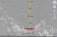
The western route, 5th leg after stop at Absecon / Reeds Bay |

The western route, 5th leg after stop at Absecon / Reeds Bay |
 Jul 11 2009, 05:57 PM Jul 11 2009, 05:57 PM
Post
#1
|
||
|
Senior Member  Group: Moderator Posts: 4279 Joined: 19-April 05 From: .br at .es Member No.: 253 |
Time for a new thread.
After moving southwards for ages, the "detour" by the western path has started with a 60+ meters drive on sol 1942.
There are no images yet --they should be available on the next update-- so this image was calculated solely based on the rover's mobility info. I'll update the route map later. |
|
 |
 
|
|
 |
|
Jul 24 2009, 11:00 AM
Post
#2
|
|
|
Solar System Cartographer Group: Members Posts: 10229 Joined: 5-April 05 From: Canada Member No.: 227 |
The crater namers forgot that they had already used the name Alvin. Check out the very first post in the Opportunity Route Map thread many years ago... So they had to re-name the crater.
Phil -------------------- ... because the Solar System ain't gonna map itself.
Also to be found posting similar content on https://mastodon.social/@PhilStooke Maps for download (free PDF: https://upload.wikimedia.org/wikipedia/comm...Cartography.pdf NOTE: everything created by me which I post on UMSF is considered to be in the public domain (NOT CC, public domain) |
|
|
|
 Tesheiner The western route Jul 11 2009, 05:57 PM
 Marz QUOTE (Tesheiner @ Jul 11 2009, 11:57 AM)... Jul 12 2009, 03:03 AM
 jamescanvin QUOTE (Marz @ Jul 12 2009, 04:03 AM) Is t... Jul 12 2009, 08:46 AM MarkG So, on this last leg to the Martian west, across m... Jul 12 2009, 05:18 AM Nirgal QUOTE (MarkG @ Jul 12 2009, 07:18 AM) So,... Jul 13 2009, 05:32 PM BrianL I thought we would have had a revised TraxMap (tm)... Jul 12 2009, 03:34 PM ustrax QUOTE (BrianL @ Jul 12 2009, 04:34 PM) I ... Jul 13 2009, 08:49 AM Astro0 Ustrax: "...not in the direction I expected..... Jul 13 2009, 11:52 AM BrianL I meant really revised, Rui. What's your take ... Jul 13 2009, 01:21 PM ustrax QUOTE (BrianL @ Jul 13 2009, 02:21 PM) I ... Jul 13 2009, 02:24 PM alan nice view
Jul 13 2009, 04:36 PM Stu You just beat me to it, Alan. You're right, fa... Jul 13 2009, 05:49 PM BrianL <clink> <clink>
What are those hills ... Jul 13 2009, 06:21 PM ustrax QUOTE (BrianL @ Jul 13 2009, 07:21 PM) ... Jul 13 2009, 06:29 PM fredk Thanks for the heads up, guys, these are great vie... Jul 13 2009, 06:52 PM ustrax Fred, if that's Iazu, let's wrap this Ende... Jul 13 2009, 07:00 PM jamescanvin Fred's right that is Iazu again - great view.
... Jul 13 2009, 07:35 PM Tesheiner Wow, what a view!
I saw that sequence (Iazu... Jul 13 2009, 08:20 PM ustrax James, sorry for asking but, that's not all Ia... Jul 13 2009, 08:25 PM fredk QUOTE (ustrax @ Jul 13 2009, 09:25 PM) th... Jul 13 2009, 09:29 PM Stu Craig Covault - speaking live on SpaceflightNow... Jul 13 2009, 08:39 PM dvandorn Stu, my understanding is that the "clays... Jul 14 2009, 02:00 AM CosmicRocker Yeah. When Endeavour became the goal, I perused t... Jul 14 2009, 05:59 AM Tesheiner Today was another driving sol, where almost 70m we... Jul 15 2009, 08:57 PM CosmicRocker I realized that I should have better referenced th... Jul 16 2009, 05:54 AM climber I while ago somebody wrote, I think it was Phil, t... Jul 16 2009, 08:31 AM ElkGroveDan QUOTE (climber @ Jul 16 2009, 01:31 AM) Y... Jul 16 2009, 02:12 PM climber QUOTE (ElkGroveDan @ Jul 16 2009, 04:12 P... Jul 16 2009, 03:38 PM Zeke4ther Ahhh....a touch of Canadian content... Jul 16 2009, 09:24 PM Phil Stooke Can't have too much of that.
Phil Jul 16 2009, 09:47 PM dot.dk Some good news in the latest update
http://mar... Jul 19 2009, 12:47 PM ustrax Hey, are these marks left my Oppy's wheels? I ... Jul 19 2009, 09:17 PM Fran Ontanaya She has done that before. The bedrock isn't ve... Jul 19 2009, 11:02 PM Tesheiner Check the navcams taken during sol 1950: http://qt... Jul 20 2009, 06:35 AM fredk QUOTE (Tesheiner @ Jul 20 2009, 07:35 AM)... Jul 24 2009, 03:53 AM Tesheiner QUOTE (fredk @ Jul 24 2009, 05:53 AM) Cou... Jul 24 2009, 08:18 AM Stu Not sure which crater this is... taken my eye off ... Jul 20 2009, 11:48 AM Tesheiner That's Alvin. Here's a navcam mosaic made ... Jul 20 2009, 04:26 PM fredk I've been watching Cape St. Mary (Beacon) in ... Jul 20 2009, 05:00 PM Tesheiner There was an "albedo pan" taken during s... Jul 20 2009, 05:12 PM Stu
Others will do better, I'm sure. I just fanc... Jul 21 2009, 02:36 PM Stu ... and t'other one...
Jul 21 2009, 02:38 PM dvandorn Hmmm... how much of what looks like good flat pave... Jul 22 2009, 01:18 AM glennwsmith Stu, very nice job on the small meteor craters. C... Jul 22 2009, 03:30 AM serpens QUOTE (glennwsmith @ Jul 22 2009, 03:30 A... Jul 23 2009, 02:50 AM Tesheiner I just checked the info from yestersol drive (1952... Jul 22 2009, 11:10 AM alan Going back for closer look at this perhaps?
From ... Jul 22 2009, 11:38 AM Sunspot QUOTE (alan @ Jul 22 2009, 12:38 PM) Goin... Jul 22 2009, 07:06 PM SFJCody Great news! This will take me more time to t... Jul 22 2009, 07:44 PM Julius What should we call that!?looks quite big to m... Jul 22 2009, 01:27 PM Tesheiner It was named "Block Island".
01946::p25... Jul 22 2009, 01:48 PM Floyd Tesheiner, would it be possible put a label for Bl... Jul 22 2009, 03:03 PM tim53 QUOTE (Floyd @ Jul 22 2009, 07:03 AM) Tes... Jul 22 2009, 06:21 PM fredk "Block Island" is actually a ways south ... Jul 22 2009, 03:17 PM BrianL Or this is a repeat of that programming glitch tha... Jul 22 2009, 03:45 PM Tesheiner No way that it would be another instance of the ... Jul 22 2009, 05:02 PM Julius So now we're sailing in the north atlantic alo... Jul 22 2009, 05:04 PM fredk I estimate Block Island is roughly 25 cm tall by 5... Jul 22 2009, 07:04 PM Reckless Hi FredK
Here's a crop of the region I think y... Jul 22 2009, 08:01 PM tim53 Roy:
It's in there!
-Tim. Jul 22 2009, 08:25 PM HughFromAlice Would someone who can see where it is please circl... Jul 22 2009, 09:22 PM tim53 QUOTE (HughFromAlice @ Jul 22 2009, 01:22... Jul 22 2009, 09:35 PM SFJCody Wow, that's a long drive back. Whatever it is ... Jul 22 2009, 09:50 PM djellison I can well understand why we're going to have ... Jul 22 2009, 09:46 PM Tesheiner Thanks for pointing the rock Tim.
Added it to the... Jul 22 2009, 10:22 PM Drkskywxlt Can someone summarize the reasons their taking the... Jul 23 2009, 12:28 AM nprev Hmm. Well, as Doug pointed out, BI is an anomaly i... Jul 23 2009, 12:48 AM ElkGroveDan QUOTE (nprev @ Jul 22 2009, 04:48 PM) Tim... Jul 23 2009, 01:06 AM fredk QUOTE (ElkGroveDan @ Jul 23 2009, 02:06 A... Jul 23 2009, 01:22 AM serpens QUOTE (fredk @ Jul 23 2009, 01:22 AM) No.... Jul 23 2009, 01:28 AM fredk QUOTE (serpens @ Jul 23 2009, 02:28 AM) S... Jul 24 2009, 12:12 AM glennwsmith Serpens, thanks for the link to the crater diamete... Jul 23 2009, 03:26 AM tim53 Doug has it. It's the biggest thing not assoc... Jul 23 2009, 04:19 AM nprev Certainly reason enough. And there I was, spinning... Jul 23 2009, 05:04 AM glennwsmith Alan, my man! What led you to this felicitous... Jul 23 2009, 05:06 AM alan Just thought 'hey that looks interesting' ... Jul 23 2009, 05:36 AM CosmicRocker QUOTE (tim53 @ Jul 22 2009, 11:19 PM) Dou... Jul 23 2009, 06:47 AM centsworth_II QUOTE (CosmicRocker @ Jul 23 2009, 01:47 ... Jul 23 2009, 04:20 PM fredk QUOTE (centsworth_II @ Jul 23 2009, 05:20... Jul 23 2009, 05:41 PM Burmese But what took the team so long to decide to turn a... Jul 23 2009, 03:01 PM fredk QUOTE (Burmese @ Jul 23 2009, 04:01 PM) B... Jul 23 2009, 03:14 PM fredk Thanks for the maps, guys. I now measure the dist... Jul 23 2009, 03:04 PM alan QUOTE (fredk @ Jul 23 2009, 10:04 AM) Do ... Jul 23 2009, 04:15 PM centsworth_II QUOTE (fredk @ Jul 23 2009, 10:04 AM) Do ... Jul 23 2009, 04:24 PM serpens QUOTE (fredk @ Jul 23 2009, 04:04 PM) Do ... Jul 23 2009, 11:21 PM CosmicRocker QUOTE (centsworth_II @ Jul 23 2009, 10:20... Jul 24 2009, 04:15 AM glennwsmith Drksywxlt, yes, the rovers have been sent on some ... Jul 24 2009, 04:24 AM climber QUOTE (glennwsmith @ Jul 24 2009, 06:24 A... Jul 24 2009, 07:25 AM djellison I guess in the category of 'turn back to go so... Jul 24 2009, 07:01 AM Tesheiner Another interesting note in the latest status repo... Jul 24 2009, 09:55 AM Tesheiner Thanks for the info, Phil.
Time for another map u... Jul 24 2009, 11:10 AM Tesheiner Here's our target "Block Island" in ... Jul 27 2009, 01:24 PM SFJCody Two foreign forms on a sand ribbed plain
One low ... Jul 27 2009, 04:38 PM Stu Land - well, something interesting - ho..!
Jul 27 2009, 04:46 PM BrianL At this distance and angle, my mind is turning tha... Jul 27 2009, 08:36 PM Bobby What are those Crab Fishermen from The Deadliest C... Jul 27 2009, 08:56 PM glennwsmith SFJCody, your poem is clever and elegant. It call... Jul 27 2009, 10:56 PM Enceladus75 The latest traverse map looks puzzling. Does thi... Jul 28 2009, 02:25 AM centsworth_II QUOTE (Enceladus75 @ Jul 27 2009, 09:25 P... Jul 28 2009, 03:13 AM
jamescanvin QUOTE (Marz @ Jul 12 2009, 04:03 AM) Is t... Jul 12 2009, 08:46 AM MarkG So, on this last leg to the Martian west, across m... Jul 12 2009, 05:18 AM Nirgal QUOTE (MarkG @ Jul 12 2009, 07:18 AM) So,... Jul 13 2009, 05:32 PM BrianL I thought we would have had a revised TraxMap (tm)... Jul 12 2009, 03:34 PM ustrax QUOTE (BrianL @ Jul 12 2009, 04:34 PM) I ... Jul 13 2009, 08:49 AM Astro0 Ustrax: "...not in the direction I expected..... Jul 13 2009, 11:52 AM BrianL I meant really revised, Rui. What's your take ... Jul 13 2009, 01:21 PM ustrax QUOTE (BrianL @ Jul 13 2009, 02:21 PM) I ... Jul 13 2009, 02:24 PM alan nice view
Jul 13 2009, 04:36 PM Stu You just beat me to it, Alan. You're right, fa... Jul 13 2009, 05:49 PM BrianL <clink> <clink>
What are those hills ... Jul 13 2009, 06:21 PM ustrax QUOTE (BrianL @ Jul 13 2009, 07:21 PM) ... Jul 13 2009, 06:29 PM fredk Thanks for the heads up, guys, these are great vie... Jul 13 2009, 06:52 PM ustrax Fred, if that's Iazu, let's wrap this Ende... Jul 13 2009, 07:00 PM jamescanvin Fred's right that is Iazu again - great view.
... Jul 13 2009, 07:35 PM Tesheiner Wow, what a view!
I saw that sequence (Iazu... Jul 13 2009, 08:20 PM ustrax James, sorry for asking but, that's not all Ia... Jul 13 2009, 08:25 PM fredk QUOTE (ustrax @ Jul 13 2009, 09:25 PM) th... Jul 13 2009, 09:29 PM Stu Craig Covault - speaking live on SpaceflightNow... Jul 13 2009, 08:39 PM dvandorn Stu, my understanding is that the "clays... Jul 14 2009, 02:00 AM CosmicRocker Yeah. When Endeavour became the goal, I perused t... Jul 14 2009, 05:59 AM Tesheiner Today was another driving sol, where almost 70m we... Jul 15 2009, 08:57 PM CosmicRocker I realized that I should have better referenced th... Jul 16 2009, 05:54 AM climber I while ago somebody wrote, I think it was Phil, t... Jul 16 2009, 08:31 AM ElkGroveDan QUOTE (climber @ Jul 16 2009, 01:31 AM) Y... Jul 16 2009, 02:12 PM climber QUOTE (ElkGroveDan @ Jul 16 2009, 04:12 P... Jul 16 2009, 03:38 PM Zeke4ther Ahhh....a touch of Canadian content... Jul 16 2009, 09:24 PM Phil Stooke Can't have too much of that.
Phil Jul 16 2009, 09:47 PM dot.dk Some good news in the latest update
http://mar... Jul 19 2009, 12:47 PM ustrax Hey, are these marks left my Oppy's wheels? I ... Jul 19 2009, 09:17 PM Fran Ontanaya She has done that before. The bedrock isn't ve... Jul 19 2009, 11:02 PM Tesheiner Check the navcams taken during sol 1950: http://qt... Jul 20 2009, 06:35 AM fredk QUOTE (Tesheiner @ Jul 20 2009, 07:35 AM)... Jul 24 2009, 03:53 AM Tesheiner QUOTE (fredk @ Jul 24 2009, 05:53 AM) Cou... Jul 24 2009, 08:18 AM Stu Not sure which crater this is... taken my eye off ... Jul 20 2009, 11:48 AM Tesheiner That's Alvin. Here's a navcam mosaic made ... Jul 20 2009, 04:26 PM fredk I've been watching Cape St. Mary (Beacon) in ... Jul 20 2009, 05:00 PM Tesheiner There was an "albedo pan" taken during s... Jul 20 2009, 05:12 PM Stu
Others will do better, I'm sure. I just fanc... Jul 21 2009, 02:36 PM Stu ... and t'other one...
Jul 21 2009, 02:38 PM dvandorn Hmmm... how much of what looks like good flat pave... Jul 22 2009, 01:18 AM glennwsmith Stu, very nice job on the small meteor craters. C... Jul 22 2009, 03:30 AM serpens QUOTE (glennwsmith @ Jul 22 2009, 03:30 A... Jul 23 2009, 02:50 AM Tesheiner I just checked the info from yestersol drive (1952... Jul 22 2009, 11:10 AM alan Going back for closer look at this perhaps?
From ... Jul 22 2009, 11:38 AM Sunspot QUOTE (alan @ Jul 22 2009, 12:38 PM) Goin... Jul 22 2009, 07:06 PM SFJCody Great news! This will take me more time to t... Jul 22 2009, 07:44 PM Julius What should we call that!?looks quite big to m... Jul 22 2009, 01:27 PM Tesheiner It was named "Block Island".
01946::p25... Jul 22 2009, 01:48 PM Floyd Tesheiner, would it be possible put a label for Bl... Jul 22 2009, 03:03 PM tim53 QUOTE (Floyd @ Jul 22 2009, 07:03 AM) Tes... Jul 22 2009, 06:21 PM fredk "Block Island" is actually a ways south ... Jul 22 2009, 03:17 PM BrianL Or this is a repeat of that programming glitch tha... Jul 22 2009, 03:45 PM Tesheiner No way that it would be another instance of the ... Jul 22 2009, 05:02 PM Julius So now we're sailing in the north atlantic alo... Jul 22 2009, 05:04 PM fredk I estimate Block Island is roughly 25 cm tall by 5... Jul 22 2009, 07:04 PM Reckless Hi FredK
Here's a crop of the region I think y... Jul 22 2009, 08:01 PM tim53 Roy:
It's in there!
-Tim. Jul 22 2009, 08:25 PM HughFromAlice Would someone who can see where it is please circl... Jul 22 2009, 09:22 PM tim53 QUOTE (HughFromAlice @ Jul 22 2009, 01:22... Jul 22 2009, 09:35 PM SFJCody Wow, that's a long drive back. Whatever it is ... Jul 22 2009, 09:50 PM djellison I can well understand why we're going to have ... Jul 22 2009, 09:46 PM Tesheiner Thanks for pointing the rock Tim.
Added it to the... Jul 22 2009, 10:22 PM Drkskywxlt Can someone summarize the reasons their taking the... Jul 23 2009, 12:28 AM nprev Hmm. Well, as Doug pointed out, BI is an anomaly i... Jul 23 2009, 12:48 AM ElkGroveDan QUOTE (nprev @ Jul 22 2009, 04:48 PM) Tim... Jul 23 2009, 01:06 AM fredk QUOTE (ElkGroveDan @ Jul 23 2009, 02:06 A... Jul 23 2009, 01:22 AM serpens QUOTE (fredk @ Jul 23 2009, 01:22 AM) No.... Jul 23 2009, 01:28 AM fredk QUOTE (serpens @ Jul 23 2009, 02:28 AM) S... Jul 24 2009, 12:12 AM glennwsmith Serpens, thanks for the link to the crater diamete... Jul 23 2009, 03:26 AM tim53 Doug has it. It's the biggest thing not assoc... Jul 23 2009, 04:19 AM nprev Certainly reason enough. And there I was, spinning... Jul 23 2009, 05:04 AM glennwsmith Alan, my man! What led you to this felicitous... Jul 23 2009, 05:06 AM alan Just thought 'hey that looks interesting' ... Jul 23 2009, 05:36 AM CosmicRocker QUOTE (tim53 @ Jul 22 2009, 11:19 PM) Dou... Jul 23 2009, 06:47 AM centsworth_II QUOTE (CosmicRocker @ Jul 23 2009, 01:47 ... Jul 23 2009, 04:20 PM fredk QUOTE (centsworth_II @ Jul 23 2009, 05:20... Jul 23 2009, 05:41 PM Burmese But what took the team so long to decide to turn a... Jul 23 2009, 03:01 PM fredk QUOTE (Burmese @ Jul 23 2009, 04:01 PM) B... Jul 23 2009, 03:14 PM fredk Thanks for the maps, guys. I now measure the dist... Jul 23 2009, 03:04 PM alan QUOTE (fredk @ Jul 23 2009, 10:04 AM) Do ... Jul 23 2009, 04:15 PM centsworth_II QUOTE (fredk @ Jul 23 2009, 10:04 AM) Do ... Jul 23 2009, 04:24 PM serpens QUOTE (fredk @ Jul 23 2009, 04:04 PM) Do ... Jul 23 2009, 11:21 PM CosmicRocker QUOTE (centsworth_II @ Jul 23 2009, 10:20... Jul 24 2009, 04:15 AM glennwsmith Drksywxlt, yes, the rovers have been sent on some ... Jul 24 2009, 04:24 AM climber QUOTE (glennwsmith @ Jul 24 2009, 06:24 A... Jul 24 2009, 07:25 AM djellison I guess in the category of 'turn back to go so... Jul 24 2009, 07:01 AM Tesheiner Another interesting note in the latest status repo... Jul 24 2009, 09:55 AM Tesheiner Thanks for the info, Phil.
Time for another map u... Jul 24 2009, 11:10 AM Tesheiner Here's our target "Block Island" in ... Jul 27 2009, 01:24 PM SFJCody Two foreign forms on a sand ribbed plain
One low ... Jul 27 2009, 04:38 PM Stu Land - well, something interesting - ho..!
Jul 27 2009, 04:46 PM BrianL At this distance and angle, my mind is turning tha... Jul 27 2009, 08:36 PM Bobby What are those Crab Fishermen from The Deadliest C... Jul 27 2009, 08:56 PM glennwsmith SFJCody, your poem is clever and elegant. It call... Jul 27 2009, 10:56 PM Enceladus75 The latest traverse map looks puzzling. Does thi... Jul 28 2009, 02:25 AM centsworth_II QUOTE (Enceladus75 @ Jul 27 2009, 09:25 P... Jul 28 2009, 03:13 AM |

|
Lo-Fi Version | Time is now: 27th September 2024 - 07:10 AM |
|
RULES AND GUIDELINES Please read the Forum Rules and Guidelines before posting. IMAGE COPYRIGHT |
OPINIONS AND MODERATION Opinions expressed on UnmannedSpaceflight.com are those of the individual posters and do not necessarily reflect the opinions of UnmannedSpaceflight.com or The Planetary Society. The all-volunteer UnmannedSpaceflight.com moderation team is wholly independent of The Planetary Society. The Planetary Society has no influence over decisions made by the UnmannedSpaceflight.com moderators. |
SUPPORT THE FORUM Unmannedspaceflight.com is funded by the Planetary Society. Please consider supporting our work and many other projects by donating to the Society or becoming a member. |
|