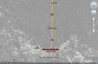
The western route, 5th leg after stop at Absecon / Reeds Bay |

The western route, 5th leg after stop at Absecon / Reeds Bay |
 Jul 11 2009, 05:57 PM Jul 11 2009, 05:57 PM
Post
#401
|
||
|
Senior Member  Group: Moderator Posts: 4279 Joined: 19-April 05 From: .br at .es Member No.: 253 |
Time for a new thread.
After moving southwards for ages, the "detour" by the western path has started with a 60+ meters drive on sol 1942.
There are no images yet --they should be available on the next update-- so this image was calculated solely based on the rover's mobility info. I'll update the route map later. |
|
 |
 
|
|
 |
|
Sep 10 2009, 05:39 PM
Post
#402
|
|
 Senior Member Group: Moderator Posts: 2785 Joined: 10-November 06 From: Pasadena, CA Member No.: 1345 |
Here are two MI images of Vail Beach, the gravelly area in front of Block Island, taken way back on Sol 1974:
http://marsrover.nasa.gov/gallery/all/1/m/...XP2956M2M1.HTML http://marsrover.nasa.gov/gallery/all/1/m/...XP2956M2M1.HTML Some heavily pitted materials can be seen in the second image (Block Island fragments?) All this begs the question: Why is Vail Beach here? Are these the result of a small long gone crater that sat well above this layer and ablated away? Heres a possible scenario: Block Island meteorite smacks into sediments and forms a crater on a plain well above the current level. As the surrounding deposits and the crater ablates away, more resistant rock and pebbles and blueberries roll and concentrate into the crater bottom. Eventually the Aeolian erosion level reaches the crater bottom and the loose friable deposits ablate away, slowly lowering the concentrated pebble fragments onto the current level we observe today. The pebbles form a nice armor, and prevent dune formation directly in front of Block Island. Behind Block Island, the lower windspeed causes sand deposition. (Just Immediately behind Block Island, there is a small patch of brighter dust visible in Stus images.) This would make Vail Beach the remnants of a fossil internal mold of a long gone crater formed when Block Island smacked into Meridiani... (This is following a train of thought that Fran Ontanaya started here.) -------------------- Some higher resolution images available at my photostream: http://www.flickr.com/photos/31678681@N07/
|
|
|
|
|
Sep 11 2009, 07:36 AM
Post
#403
|
|
|
Member Group: Members Posts: 258 Joined: 22-December 06 Member No.: 1503 |
QUOTE (Juramike @ Sep 10 2009, 12:39 PM)  Here are two MI images of Vail Beach, the gravelly area in front of Block Island, taken way back on Sol 1974: http://marsrover.nasa.gov/gallery/all/1/m/...XP2956M2M1.HTML http://marsrover.nasa.gov/gallery/all/1/m/...XP2956M2M1.HTML Some heavily pitted materials can be seen in the second image (Block Island fragments?) All this begs the question: Why is Vail Beach here? Are these the result of a small long gone crater that sat well above this layer and ablated away? Heres a possible scenario: Block Island meteorite smacks into sediments and forms a crater on a plain well above the current level. As the surrounding deposits and the crater ablates away, more resistant rock and pebbles and blueberries roll and concentrate into the crater bottom. Eventually the Aeolian erosion level reaches the crater bottom and the loose friable deposits ablate away, slowly lowering the concentrated pebble fragments onto the current level we observe today. The pebbles form a nice armor, and prevent dune formation directly in front of Block Island. Behind Block Island, the lower windspeed causes sand deposition. (Just Immediately behind Block Island, there is a small patch of brighter dust visible in Stus images.) This would make Vail Beach the remnants of a fossil internal mold of a long gone crater formed when Block Island smacked into Meridiani... (This is following a train of thought that Fran Ontanaya started here.) I see one major problem with this line of thought. Let's take a look at the bigger picture. Why are all the iron meteorites exactly on the surface, not just this one? If there was surface excavation along with ablation through wind erosion, then the chances that these would all be on the surface would be next to zero. At least some of these big meteorites should be at least partially embedded into the ground. But if the former surface that is now gone used to be ice, then everything makes sense. The meteorites would eventually all sink down to the same level were there was no more sublimating ice. Everything would appear to be gently laid down on top of the surface - because basically it was. Do we have any examples of iron meteorites at Meridiani embedded into the ground where only part of it can be seen? |
|
|
|
|
Sep 11 2009, 02:19 PM
Post
#404
|
|
|
Senior Member Group: Moderator Posts: 2785 Joined: 10-November 06 From: Pasadena, CA Member No.: 1345 |
QUOTE (MarsIsImportant @ Sep 11 2009, 02:36 AM) If there was surface excavation along with ablation through wind erosion, then the chances that these would all be on the surface would be next to zero. At least some of these big meteorites should be at least partially embedded into the ground. This is probably giving us an idea of rate of "resistant" impacts vs. ablation erosion rate. Imagine a surface dotted with craters of varying depth. Some containing resistant meteorites. If the cratering rate (of resistant impactors) was really high, and the erosion rate really high: then we should see exposed meteorites all over the place. There would be a few still partially buried, but those would get completely exposed in the blink of an eye. (Once exposed, they remain exposed. The time it would take to exhume would be the time it took for the surrounding sediments to be removed along the Z coordinate of the embedded meteorite.) If the cratering rate (of resistant impactors) was really low, and the erosion rate really high: then we should see a few exposed meteorites lying around completely exhumed, only a few would be buried (but not for long). If the cratering rate was high, and the erosion rate really low: then we would see only a few popping out of the surface. Most would still be buried (and they'd stay that way for a while) If the cratering rate was low and the erosion rate low, then the few resistant impactors would be buried. We've got an n=3 of exposed meteorites that we've seen in our journeys. Is this a "few" or "a lot" or "all over the place"? The unknowns are still the resistant meteorite cratering rate and average emplacement depths (most of the meteorites are within a few orders of magnitude in size), the absolute time-averaged erosion rate, the absolute age of the current surface, and the absolute age of the highest layer in the historical stack. At least we can safely say that the resistant-impactor cratering rate is significantly above "never". -------------------- Some higher resolution images available at my photostream: http://www.flickr.com/photos/31678681@N07/
|
|
|
|
 Tesheiner The western route Jul 11 2009, 05:57 PM
 nprev Correct; was making a bad UMSF-related joke, sorry... Sep 8 2009, 06:29 AM
 marsophile QUOTE (nprev @ Sep 7 2009, 10:29 PM) ...b... Sep 8 2009, 03:42 PM ElkGroveDan QUOTE (marsophile @ Sep 8 2009, 07:42 AM)... Sep 8 2009, 03:49 PM djellison Agreed - this thing is several hundred KG, more th... Sep 8 2009, 03:50 PM eoincampbell Could Heat Shield and Block Island have been part ... Sep 8 2009, 04:08 PM djellison QUOTE (eoincampbell @ Sep 8 2009, 05:08 P... Sep 8 2009, 04:45 PM serpens QUOTE (djellison @ Sep 8 2009, 04:45 PM) ... Sep 8 2009, 11:01 PM marsophile Is there any hope of inferring anything about the ... Sep 8 2009, 07:23 PM centsworth_II "It's a rock!"
"It's no... Sep 8 2009, 11:38 PM Stu More progress around Block Island...
Sep 9 2009, 01:31 PM Juramike QUOTE (Stu @ Sep 9 2009, 08:31 AM) More p... Sep 9 2009, 02:09 PM Stu ... and in colour....
Sep 9 2009, 02:09 PM fredk ...and in pancam 3D. We can now see most of the ... Sep 9 2009, 02:23 PM ElkGroveDan QUOTE (fredk @ Sep 9 2009, 06:23 AM) ...a... Sep 9 2009, 09:49 PM mhoward Simulated view of Opportunity at Block Island, for... Sep 9 2009, 04:22 PM Astro0 mhoward: Simulated view of Opportunity at Block Is... Sep 9 2009, 11:11 PM Stu Latest postcards from Oppy's "Tour of Blo... Sep 10 2009, 01:21 PM Ant103 Hi
My owns versions of BI views from different s... Sep 10 2009, 02:05 PM fredk Beautiful views, thanks Stu! The last view cl... Sep 10 2009, 02:07 PM fredk And more beautiful views, Ant! Just one littl... Sep 10 2009, 02:14 PM MarkG As far as the shape and surface textures of Block ... Sep 10 2009, 03:47 PM serpens QUOTE (MarkG @ Sep 10 2009, 04:47 PM) it ... Sep 11 2009, 12:50 AM Ant103 QUOTE (fredk @ Sep 10 2009, 04:14 PM) And... Sep 10 2009, 04:15 PM eoincampbell What's the theory behind the cavity? Could the... Sep 10 2009, 04:19 PM Airbag QUOTE (eoincampbell @ Sep 10 2009, 12:19 ... Sep 22 2009, 01:53 AM antoniseb QUOTE (MarsIsImportant @ Sep 11 2009, 01... Sep 11 2009, 12:08 PM ilbasso QUOTE (Juramike @ Sep 11 2009, 10:19 AM) ... Sep 11 2009, 03:59 PM stewjack QUOTE (ilbasso @ Sep 11 2009, 10:59 AM) .... Sep 11 2009, 06:49 PM serpens QUOTE (stewjack @ Sep 11 2009, 06:49 PM) ... Sep 14 2009, 12:53 AM centsworth_II QUOTE (ilbasso @ Sep 11 2009, 11:59 AM) .... Sep 12 2009, 02:05 AM centsworth_II QUOTE (MarsIsImportant @ Sep 11 2009, 03... Sep 12 2009, 01:59 AM Astro0 Updated animation of the circumnavigation of Block... Sep 10 2009, 10:52 PM dvandorn Mike, you're describing a lag deposit, of whic... Sep 11 2009, 01:13 AM fredk From the latest update:
QUOTE The plan is to compl... Sep 11 2009, 03:29 AM Tesheiner Today's plan (sol 2002) is move to the sixth (... Sep 11 2009, 04:53 AM Stu QUOTE (dvandorn @ Sep 11 2009, 02:13 AM) ... Sep 11 2009, 05:31 AM serpens Every crater has a probable buried meteorite - or ... Sep 11 2009, 10:39 AM john_s The biggest difference from Earth is just the surf... Sep 12 2009, 04:09 PM Stu Latest postcard home from Oppy as she continues he... Sep 12 2009, 05:09 PM Stu Opportunity's 2009 Tour of Block Island...
ht... Sep 12 2009, 08:12 PM Astro0 One good turn deserves another....animation that i... Sep 12 2009, 10:34 PM alan QUOTE (Astro0 @ Sep 12 2009, 05:34 PM) On... Sep 13 2009, 02:44 AM Stu QUOTE (Astro0 @ Sep 12 2009, 11:34 PM) On... Sep 13 2009, 06:13 AM JayB http://twitter.com/MarsRovers/statuses/3943115122
... Sep 13 2009, 03:33 AM Tesheiner QUOTE (JayB @ Sep 13 2009, 05:33 AM) http... Sep 13 2009, 06:59 AM Juramike MI mosaic of Vail Beach assembled from 4 of the im... Sep 13 2009, 03:35 AM Juramike Sol1974 Vail Beach MI Mosaic localized. It is jus... Sep 14 2009, 12:57 AM Shaka No MI's of the blueberries on BI? .....hmm Sep 14 2009, 03:17 AM Stu Probably my last close-up colourisation of Block I... Sep 14 2009, 01:54 PM climber QUOTE (Stu @ Sep 14 2009, 03:54 PM) I kno... Sep 14 2009, 03:42 PM Tesheiner Moved a few posts to (what I think is) the current... Sep 14 2009, 10:11 PM Astro0 OK, one more animation of Block Island.
This time ... Sep 15 2009, 03:06 AM elakdawalla That's pretty cool! But it hardly looks l... Sep 15 2009, 03:15 AM Astro0 Thanks Emily.
BTW - you are the official winner of... Sep 15 2009, 04:32 AM elakdawalla Thank Doug for the UMSF branding, it was his gift ... Sep 15 2009, 06:03 AM CosmicRocker Agreed. The assumption that Block Island was orig... Sep 23 2009, 04:35 AM elakdawalla Hey rover fans, I am preparing my "Year in Pi... Sep 28 2009, 06:14 PM jamescanvin I've played around with alternative projection... Sep 29 2009, 07:55 AM Tman Had just an "inspiration" that one could... Oct 19 2009, 10:00 AM
marsophile QUOTE (nprev @ Sep 7 2009, 10:29 PM) ...b... Sep 8 2009, 03:42 PM ElkGroveDan QUOTE (marsophile @ Sep 8 2009, 07:42 AM)... Sep 8 2009, 03:49 PM djellison Agreed - this thing is several hundred KG, more th... Sep 8 2009, 03:50 PM eoincampbell Could Heat Shield and Block Island have been part ... Sep 8 2009, 04:08 PM djellison QUOTE (eoincampbell @ Sep 8 2009, 05:08 P... Sep 8 2009, 04:45 PM serpens QUOTE (djellison @ Sep 8 2009, 04:45 PM) ... Sep 8 2009, 11:01 PM marsophile Is there any hope of inferring anything about the ... Sep 8 2009, 07:23 PM centsworth_II "It's a rock!"
"It's no... Sep 8 2009, 11:38 PM Stu More progress around Block Island...
Sep 9 2009, 01:31 PM Juramike QUOTE (Stu @ Sep 9 2009, 08:31 AM) More p... Sep 9 2009, 02:09 PM Stu ... and in colour....
Sep 9 2009, 02:09 PM fredk ...and in pancam 3D. We can now see most of the ... Sep 9 2009, 02:23 PM ElkGroveDan QUOTE (fredk @ Sep 9 2009, 06:23 AM) ...a... Sep 9 2009, 09:49 PM mhoward Simulated view of Opportunity at Block Island, for... Sep 9 2009, 04:22 PM Astro0 mhoward: Simulated view of Opportunity at Block Is... Sep 9 2009, 11:11 PM Stu Latest postcards from Oppy's "Tour of Blo... Sep 10 2009, 01:21 PM Ant103 Hi
My owns versions of BI views from different s... Sep 10 2009, 02:05 PM fredk Beautiful views, thanks Stu! The last view cl... Sep 10 2009, 02:07 PM fredk And more beautiful views, Ant! Just one littl... Sep 10 2009, 02:14 PM MarkG As far as the shape and surface textures of Block ... Sep 10 2009, 03:47 PM serpens QUOTE (MarkG @ Sep 10 2009, 04:47 PM) it ... Sep 11 2009, 12:50 AM Ant103 QUOTE (fredk @ Sep 10 2009, 04:14 PM) And... Sep 10 2009, 04:15 PM eoincampbell What's the theory behind the cavity? Could the... Sep 10 2009, 04:19 PM Airbag QUOTE (eoincampbell @ Sep 10 2009, 12:19 ... Sep 22 2009, 01:53 AM antoniseb QUOTE (MarsIsImportant @ Sep 11 2009, 01... Sep 11 2009, 12:08 PM ilbasso QUOTE (Juramike @ Sep 11 2009, 10:19 AM) ... Sep 11 2009, 03:59 PM stewjack QUOTE (ilbasso @ Sep 11 2009, 10:59 AM) .... Sep 11 2009, 06:49 PM serpens QUOTE (stewjack @ Sep 11 2009, 06:49 PM) ... Sep 14 2009, 12:53 AM centsworth_II QUOTE (ilbasso @ Sep 11 2009, 11:59 AM) .... Sep 12 2009, 02:05 AM centsworth_II QUOTE (MarsIsImportant @ Sep 11 2009, 03... Sep 12 2009, 01:59 AM Astro0 Updated animation of the circumnavigation of Block... Sep 10 2009, 10:52 PM dvandorn Mike, you're describing a lag deposit, of whic... Sep 11 2009, 01:13 AM fredk From the latest update:
QUOTE The plan is to compl... Sep 11 2009, 03:29 AM Tesheiner Today's plan (sol 2002) is move to the sixth (... Sep 11 2009, 04:53 AM Stu QUOTE (dvandorn @ Sep 11 2009, 02:13 AM) ... Sep 11 2009, 05:31 AM serpens Every crater has a probable buried meteorite - or ... Sep 11 2009, 10:39 AM john_s The biggest difference from Earth is just the surf... Sep 12 2009, 04:09 PM Stu Latest postcard home from Oppy as she continues he... Sep 12 2009, 05:09 PM Stu Opportunity's 2009 Tour of Block Island...
ht... Sep 12 2009, 08:12 PM Astro0 One good turn deserves another....animation that i... Sep 12 2009, 10:34 PM alan QUOTE (Astro0 @ Sep 12 2009, 05:34 PM) On... Sep 13 2009, 02:44 AM Stu QUOTE (Astro0 @ Sep 12 2009, 11:34 PM) On... Sep 13 2009, 06:13 AM JayB http://twitter.com/MarsRovers/statuses/3943115122
... Sep 13 2009, 03:33 AM Tesheiner QUOTE (JayB @ Sep 13 2009, 05:33 AM) http... Sep 13 2009, 06:59 AM Juramike MI mosaic of Vail Beach assembled from 4 of the im... Sep 13 2009, 03:35 AM Juramike Sol1974 Vail Beach MI Mosaic localized. It is jus... Sep 14 2009, 12:57 AM Shaka No MI's of the blueberries on BI? .....hmm Sep 14 2009, 03:17 AM Stu Probably my last close-up colourisation of Block I... Sep 14 2009, 01:54 PM climber QUOTE (Stu @ Sep 14 2009, 03:54 PM) I kno... Sep 14 2009, 03:42 PM Tesheiner Moved a few posts to (what I think is) the current... Sep 14 2009, 10:11 PM Astro0 OK, one more animation of Block Island.
This time ... Sep 15 2009, 03:06 AM elakdawalla That's pretty cool! But it hardly looks l... Sep 15 2009, 03:15 AM Astro0 Thanks Emily.
BTW - you are the official winner of... Sep 15 2009, 04:32 AM elakdawalla Thank Doug for the UMSF branding, it was his gift ... Sep 15 2009, 06:03 AM CosmicRocker Agreed. The assumption that Block Island was orig... Sep 23 2009, 04:35 AM elakdawalla Hey rover fans, I am preparing my "Year in Pi... Sep 28 2009, 06:14 PM jamescanvin I've played around with alternative projection... Sep 29 2009, 07:55 AM Tman Had just an "inspiration" that one could... Oct 19 2009, 10:00 AM |

|
Lo-Fi Version | Time is now: 5th June 2024 - 07:42 AM |
|
RULES AND GUIDELINES Please read the Forum Rules and Guidelines before posting. IMAGE COPYRIGHT |
OPINIONS AND MODERATION Opinions expressed on UnmannedSpaceflight.com are those of the individual posters and do not necessarily reflect the opinions of UnmannedSpaceflight.com or The Planetary Society. The all-volunteer UnmannedSpaceflight.com moderation team is wholly independent of The Planetary Society. The Planetary Society has no influence over decisions made by the UnmannedSpaceflight.com moderators. |
SUPPORT THE FORUM Unmannedspaceflight.com is funded by the Planetary Society. Please consider supporting our work and many other projects by donating to the Society or becoming a member. |
|