Gusev terrain, some data from CRISM and HiRISE |

Gusev terrain, some data from CRISM and HiRISE |
 Mar 25 2009, 10:11 AM Mar 25 2009, 10:11 AM
Post
#1
|
|||
 Member  Group: Members Posts: 236 Joined: 5-June 08 From: Udon Thani Member No.: 4185 |
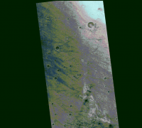
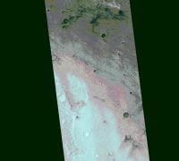
Computer generated terrain clasification based on HiRISE for area north and south of Columbia hills. Colors mark areas which have the same average grid brightness and the same variance. The colors in themselves have no meaning, they are just used to show the different terrains.
Both images are at 16 mtr / pixel map aligned. |
||
 |
 
|
||
 |
|
Sep 24 2009, 02:00 PM
Post
#2
|
|
 Junior Member Group: Members Posts: 57 Joined: 17-May 06 From: Houston, Texas Member No.: 776 |
If Home Plate is supposed to be a fumarole, could Pitchers Mound be a volcanic cone?
-------------------- |
|
|
|
 Geert Gusev terrain Mar 25 2009, 10:11 AM
 Geert
Distribution of Iron and Ferric minerals as meas... Mar 25 2009, 10:24 AM Geert
Distribution of Iron and Ferric minerals in home... Mar 25 2009, 10:37 AM Geert
Distribution of mafic minerals (mainly pyroxenes... Mar 25 2009, 10:46 AM Geert
Bonneville crater showing computer terrain quali... Mar 25 2009, 10:55 AM Geert
Unnamed crater at aprox 14.752 S and 175.572E sh... Mar 25 2009, 11:02 AM
Geert
Distribution of Iron and Ferric minerals as meas... Mar 25 2009, 10:24 AM Geert
Distribution of Iron and Ferric minerals in home... Mar 25 2009, 10:37 AM Geert
Distribution of mafic minerals (mainly pyroxenes... Mar 25 2009, 10:46 AM Geert
Bonneville crater showing computer terrain quali... Mar 25 2009, 10:55 AM Geert
Unnamed crater at aprox 14.752 S and 175.572E sh... Mar 25 2009, 11:02 AM
 PaulM Gusev crater once most likely contained a lake. Th... Mar 26 2009, 12:28 PM Phil Stooke A mud flow might be a better description... doesn... Mar 26 2009, 08:09 PM
 |

|
Lo-Fi Version | Time is now: 3rd June 2024 - 10:58 PM |
|
RULES AND GUIDELINES Please read the Forum Rules and Guidelines before posting. IMAGE COPYRIGHT |
OPINIONS AND MODERATION Opinions expressed on UnmannedSpaceflight.com are those of the individual posters and do not necessarily reflect the opinions of UnmannedSpaceflight.com or The Planetary Society. The all-volunteer UnmannedSpaceflight.com moderation team is wholly independent of The Planetary Society. The Planetary Society has no influence over decisions made by the UnmannedSpaceflight.com moderators. |
SUPPORT THE FORUM Unmannedspaceflight.com is funded by the Planetary Society. Please consider supporting our work and many other projects by donating to the Society or becoming a member. |
|