LCROSS en route |

LCROSS en route |
 Jul 15 2009, 03:08 PM Jul 15 2009, 03:08 PM
Post
#1
|
||
 Junior Member  Group: Members Posts: 87 Joined: 9-November 07 Member No.: 3958 |
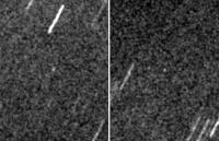
While we're waiting for Those Pictures, here are a couple of shots of LCROSS from our campus observatory last night (0221, 027 UT on 15 July). 4 minute exposures tracking expected motion from the Horizons ephemeris, within 20 degrees of the southern horizon and fighting summertime haze as well as city lights. I wanted to catch it before its inclined orbit takes it too far south, after which it spends a week or so as a predawn object. The range was about 563,000 km, and the Centaur is no bigger than a CSM/LM combination, so this is a more difficult target than spotting an Apollo enroute was. (On the other hand, nobody had CCD imagers in 1969).
|
|
 |
 
|
|
 |
|
Oct 2 2009, 08:06 PM
Post
#2
|
|
|
Solar System Cartographer Group: Members Posts: 10227 Joined: 5-April 05 From: Canada Member No.: 227 |
From the Observation Group website:
------------------------- Hello Team! Latest update on impact locations: Centaur: -84.70, 310.95E SSC: -84.77, 310.45E These are final and should not change. Nominal timing for impacts: Centaur = 9 Oct 2009 11:31:30 UTC SSC = 9 Oct 2009 11:35:45 UTC There may be some variation from these nominal times through remaining trajectory correction maneuvering. We will post updates to these times as they become available. Any timing updates on impact night will be posted to LCROSS Twitter page, LCROSS Facebook page, and LCROSS-CS. Brian ---------------------- Final LCROSS Centaur and SSC target coordinates (Lat., Lon. in ME) Centaur: -84.675, 311.275 E SSC: -84.729, 310.64 E Elevations (Assumed Lunar radius: 1737.4 km): Centaur target elev: -3.82693 km SSC target elev: -3.80909 km Impact Times: Centaur: 9 Oct 2009 11:31:30 UTC SSC: 9 Oct 2009 11:35:45 UTC Note: These are nominal impact positions and times. Actual impact times based on TCM results may differ (see next slide for uncertainties) ---------------------------- That point is slightly west of the position shown on my map. Phil -------------------- ... because the Solar System ain't gonna map itself.
Also to be found posting similar content on https://mastodon.social/@PhilStooke Maps for download (free PDF: https://upload.wikimedia.org/wikipedia/comm...Cartography.pdf NOTE: everything created by me which I post on UMSF is considered to be in the public domain (NOT CC, public domain) |
|
|
|
 NGC3314 LCROSS en route Jul 15 2009, 03:08 PM
 nprev Sweet!!!
What's your campus scop... Jul 15 2009, 10:44 PM
nprev Sweet!!!
What's your campus scop... Jul 15 2009, 10:44 PM
 NGC3314 0.4m Ritchey-Chretien, using one of the big Santa ... Jul 16 2009, 02:52 AM Lewis007 An article on the "cold side bake-out" p... Aug 10 2009, 07:25 AM mps LCROSS experienced an anomaly: http://www.nasa.gov... Aug 25 2009, 06:43 AM Zvezdichko Oh, this is BAD! But they are optimistic that ... Aug 25 2009, 09:46 AM nprev Wow. Is the IRU in question part of the Centaur it... Aug 25 2009, 12:39 PM ugordan Hmm, I thought star trackers were the de facto met... Aug 25 2009, 01:03 PM John Moore There were some initial problems with the star tra... Aug 25 2009, 05:00 PM Lewis007 On August 17, LCROSS took additional images of the... Aug 26 2009, 06:41 AM Marz Here's a Spaceflight article explaining the re... Aug 26 2009, 03:27 PM Astro0 In response to the Spaceflight Now article, this r... Aug 27 2009, 02:12 AM nprev Good info, all (thanks for the late-breaking, Astr... Aug 27 2009, 02:21 AM climber More good news: http://www.spaceref.com/news/views... Sep 5 2009, 05:33 PM Astro0 Nice memo to the LCROSS team and well deserved.
I ... Sep 5 2009, 11:37 PM climber QUOTE (Astro0 @ Sep 6 2009, 01:37 AM) I... Sep 6 2009, 11:40 AM stevesliva QUOTE (Astro0 @ Sep 5 2009, 07:37 PM) I... Sep 6 2009, 11:37 PM Paolo Just announced: impact in Cabeus A Sep 11 2009, 05:13 PM Hungry4info Quick question regarding DSN time between Cassini ... Sep 11 2009, 05:16 PM elakdawalla Anybody see any graphics online anywhere? I'v... Sep 11 2009, 05:33 PM ugordan FWIW, this post over at the NSF.com forum has an i... Sep 11 2009, 05:55 PM John Moore Cabeus A crater location...the impacts should be v... Sep 11 2009, 06:00 PM Phil Stooke "Quick question regarding DSN time between Ca... Sep 11 2009, 09:15 PM Ron Hobbs The above link doesn't work for me; try this o... Sep 11 2009, 10:33 PM belleraphon1 For those who missed the briefing here it is on Yo... Sep 11 2009, 11:19 PM eoincampbell Thank you for posting that very informative press ... Sep 12 2009, 05:56 AM PhilCo126 For those hoping to see the impact; here're th... Sep 12 2009, 08:05 AM Tman Here a GIF animation of the Moon phase and the vis... Sep 13 2009, 03:50 PM Paolo Target crater switched from Cabeus A to Cabeus (pr... Sep 28 2009, 08:46 PM John Moore I would think that they'll probably aim for th... Sep 29 2009, 01:03 PM Phil Stooke http://www.nasa.gov/pdf/386497main_target-selectio... Sep 29 2009, 01:45 PM John Moore Thanks Phil
Page 19 is very useful and probably m... Sep 29 2009, 03:06 PM tanjent Note that in the Colaprete report the Earth observ... Sep 29 2009, 04:34 PM Phil Stooke The latest release did refer to new topographic da... Sep 29 2009, 04:55 PM elakdawalla Ask and ye shall receive I asked your questions ... Sep 29 2009, 08:19 PM Phil Stooke Here's a map of the approximate locations of t... Oct 2 2009, 03:30 PM elakdawalla What are the coordinates of the different impact s... Oct 2 2009, 04:03 PM Tman The Google group of LCROSS (amateur) Observation h... Oct 2 2009, 04:35 PM dmuller QUOTE (Phil Stooke @ Oct 3 2009, 06:06 AM... Oct 4 2009, 12:53 AM John Moore Took the latter coords., -- rough idea, therefore,... Oct 2 2009, 10:41 PM Phil Stooke Here's the latest info from Tony Colaprete, vi... Oct 3 2009, 08:45 PM John Moore That's better!
The recent DIVINER image ... Oct 4 2009, 02:01 PM Phil Stooke This is what I get by overlaying Colaprete's m... Oct 4 2009, 02:36 PM John Moore Isn't that exact same as in my link above?
Jo... Oct 4 2009, 03:45 PM Phil Stooke It's the image processing that's different... Oct 4 2009, 03:59 PM centsworth_II Here's the map comparison that interests me: T... Oct 4 2009, 04:59 PM Phil Stooke Also the map of hydrogen concentrations is very mo... Oct 4 2009, 05:07 PM Phil Stooke This is a comparison of the points John and I matc... Oct 4 2009, 05:18 PM JGodbaz QUOTE (centsworth_II @ Oct 5 2009, 05:59 ... Oct 5 2009, 08:10 AM centsworth_II QUOTE (JGodbaz @ Oct 5 2009, 03:10 AM) Th... Oct 5 2009, 03:34 PM John Moore @ Phil...ah yes...see what you mean, your points a... Oct 5 2009, 11:00 AM Phil Stooke John, it's only the 'quote' business t... Oct 5 2009, 11:16 AM Phil Stooke It's hard to keep these maps up to date! ... Oct 6 2009, 01:16 AM JGodbaz Thanks, I wasn't aware of the new release.
I... Oct 6 2009, 01:31 AM Phil Stooke If it was worse, would they have chosen it? They ... Oct 6 2009, 01:37 AM JGodbaz They don't have a lot of choice as there aren... Oct 6 2009, 01:42 AM Phil Stooke I think you're right. I bet the site selectio... Oct 6 2009, 01:47 AM PDP8E impact is Oct 9, 7:30am-ish local time with the su... Oct 6 2009, 03:06 AM ElkGroveDan QUOTE (PDP8E @ Oct 5 2009, 08:06 PM) impa... Oct 6 2009, 04:12 PM Marz QUOTE (ElkGroveDan @ Oct 6 2009, 11:12 AM... Oct 6 2009, 05:23 PM MahFL "NASA to Bomb the Moon Friday "
Good god... Oct 6 2009, 06:09 PM centsworth_II QUOTE (MahFL @ Oct 6 2009, 02:09 PM) ... Oct 6 2009, 06:30 PM centsworth_II QUOTE (MahFL @ Oct 6 2009, 01:09 PM) ... Oct 8 2009, 11:13 PM Stu QUOTE (Marz @ Oct 6 2009, 06:23 PM) I jus... Oct 6 2009, 09:52 PM Phil Stooke Ahh, good old Social Media! Lots of entertain... Oct 6 2009, 02:36 PM nprev Okay, I'm convinced. Gonna dust off the ol... Oct 7 2009, 12:05 AM AndyG I suspect it won't be up to Gervase of Canterb... Oct 7 2009, 08:52 AM MahFL A far far better report. Good to see media coverag... Oct 8 2009, 11:50 AM centsworth_II LCROSS audio briefing HERE.
QUOTE Thursday, Oct. ... Oct 8 2009, 05:38 PM scalbers Wonder if there are any flyover movies (or sequenc... Oct 8 2009, 07:44 PM Phil Stooke
Phil Oct 8 2009, 07:52 PM nprev AAACKKK!!!! I thought he was gonna... Oct 8 2009, 08:14 PM scalbers Here's a crude attempt at animating the lunar ... Oct 8 2009, 09:14 PM nprev LCROSS- Centaur separation succesful!!... Oct 9 2009, 02:15 AM
NGC3314 0.4m Ritchey-Chretien, using one of the big Santa ... Jul 16 2009, 02:52 AM Lewis007 An article on the "cold side bake-out" p... Aug 10 2009, 07:25 AM mps LCROSS experienced an anomaly: http://www.nasa.gov... Aug 25 2009, 06:43 AM Zvezdichko Oh, this is BAD! But they are optimistic that ... Aug 25 2009, 09:46 AM nprev Wow. Is the IRU in question part of the Centaur it... Aug 25 2009, 12:39 PM ugordan Hmm, I thought star trackers were the de facto met... Aug 25 2009, 01:03 PM John Moore There were some initial problems with the star tra... Aug 25 2009, 05:00 PM Lewis007 On August 17, LCROSS took additional images of the... Aug 26 2009, 06:41 AM Marz Here's a Spaceflight article explaining the re... Aug 26 2009, 03:27 PM Astro0 In response to the Spaceflight Now article, this r... Aug 27 2009, 02:12 AM nprev Good info, all (thanks for the late-breaking, Astr... Aug 27 2009, 02:21 AM climber More good news: http://www.spaceref.com/news/views... Sep 5 2009, 05:33 PM Astro0 Nice memo to the LCROSS team and well deserved.
I ... Sep 5 2009, 11:37 PM climber QUOTE (Astro0 @ Sep 6 2009, 01:37 AM) I... Sep 6 2009, 11:40 AM stevesliva QUOTE (Astro0 @ Sep 5 2009, 07:37 PM) I... Sep 6 2009, 11:37 PM Paolo Just announced: impact in Cabeus A Sep 11 2009, 05:13 PM Hungry4info Quick question regarding DSN time between Cassini ... Sep 11 2009, 05:16 PM elakdawalla Anybody see any graphics online anywhere? I'v... Sep 11 2009, 05:33 PM ugordan FWIW, this post over at the NSF.com forum has an i... Sep 11 2009, 05:55 PM John Moore Cabeus A crater location...the impacts should be v... Sep 11 2009, 06:00 PM Phil Stooke "Quick question regarding DSN time between Ca... Sep 11 2009, 09:15 PM Ron Hobbs The above link doesn't work for me; try this o... Sep 11 2009, 10:33 PM belleraphon1 For those who missed the briefing here it is on Yo... Sep 11 2009, 11:19 PM eoincampbell Thank you for posting that very informative press ... Sep 12 2009, 05:56 AM PhilCo126 For those hoping to see the impact; here're th... Sep 12 2009, 08:05 AM Tman Here a GIF animation of the Moon phase and the vis... Sep 13 2009, 03:50 PM Paolo Target crater switched from Cabeus A to Cabeus (pr... Sep 28 2009, 08:46 PM John Moore I would think that they'll probably aim for th... Sep 29 2009, 01:03 PM Phil Stooke http://www.nasa.gov/pdf/386497main_target-selectio... Sep 29 2009, 01:45 PM John Moore Thanks Phil
Page 19 is very useful and probably m... Sep 29 2009, 03:06 PM tanjent Note that in the Colaprete report the Earth observ... Sep 29 2009, 04:34 PM Phil Stooke The latest release did refer to new topographic da... Sep 29 2009, 04:55 PM elakdawalla Ask and ye shall receive I asked your questions ... Sep 29 2009, 08:19 PM Phil Stooke Here's a map of the approximate locations of t... Oct 2 2009, 03:30 PM elakdawalla What are the coordinates of the different impact s... Oct 2 2009, 04:03 PM Tman The Google group of LCROSS (amateur) Observation h... Oct 2 2009, 04:35 PM dmuller QUOTE (Phil Stooke @ Oct 3 2009, 06:06 AM... Oct 4 2009, 12:53 AM John Moore Took the latter coords., -- rough idea, therefore,... Oct 2 2009, 10:41 PM Phil Stooke Here's the latest info from Tony Colaprete, vi... Oct 3 2009, 08:45 PM John Moore That's better!
The recent DIVINER image ... Oct 4 2009, 02:01 PM Phil Stooke This is what I get by overlaying Colaprete's m... Oct 4 2009, 02:36 PM John Moore Isn't that exact same as in my link above?
Jo... Oct 4 2009, 03:45 PM Phil Stooke It's the image processing that's different... Oct 4 2009, 03:59 PM centsworth_II Here's the map comparison that interests me: T... Oct 4 2009, 04:59 PM Phil Stooke Also the map of hydrogen concentrations is very mo... Oct 4 2009, 05:07 PM Phil Stooke This is a comparison of the points John and I matc... Oct 4 2009, 05:18 PM JGodbaz QUOTE (centsworth_II @ Oct 5 2009, 05:59 ... Oct 5 2009, 08:10 AM centsworth_II QUOTE (JGodbaz @ Oct 5 2009, 03:10 AM) Th... Oct 5 2009, 03:34 PM John Moore @ Phil...ah yes...see what you mean, your points a... Oct 5 2009, 11:00 AM Phil Stooke John, it's only the 'quote' business t... Oct 5 2009, 11:16 AM Phil Stooke It's hard to keep these maps up to date! ... Oct 6 2009, 01:16 AM JGodbaz Thanks, I wasn't aware of the new release.
I... Oct 6 2009, 01:31 AM Phil Stooke If it was worse, would they have chosen it? They ... Oct 6 2009, 01:37 AM JGodbaz They don't have a lot of choice as there aren... Oct 6 2009, 01:42 AM Phil Stooke I think you're right. I bet the site selectio... Oct 6 2009, 01:47 AM PDP8E impact is Oct 9, 7:30am-ish local time with the su... Oct 6 2009, 03:06 AM ElkGroveDan QUOTE (PDP8E @ Oct 5 2009, 08:06 PM) impa... Oct 6 2009, 04:12 PM Marz QUOTE (ElkGroveDan @ Oct 6 2009, 11:12 AM... Oct 6 2009, 05:23 PM MahFL "NASA to Bomb the Moon Friday "
Good god... Oct 6 2009, 06:09 PM centsworth_II QUOTE (MahFL @ Oct 6 2009, 02:09 PM) ... Oct 6 2009, 06:30 PM centsworth_II QUOTE (MahFL @ Oct 6 2009, 01:09 PM) ... Oct 8 2009, 11:13 PM Stu QUOTE (Marz @ Oct 6 2009, 06:23 PM) I jus... Oct 6 2009, 09:52 PM Phil Stooke Ahh, good old Social Media! Lots of entertain... Oct 6 2009, 02:36 PM nprev Okay, I'm convinced. Gonna dust off the ol... Oct 7 2009, 12:05 AM AndyG I suspect it won't be up to Gervase of Canterb... Oct 7 2009, 08:52 AM MahFL A far far better report. Good to see media coverag... Oct 8 2009, 11:50 AM centsworth_II LCROSS audio briefing HERE.
QUOTE Thursday, Oct. ... Oct 8 2009, 05:38 PM scalbers Wonder if there are any flyover movies (or sequenc... Oct 8 2009, 07:44 PM Phil Stooke
Phil Oct 8 2009, 07:52 PM nprev AAACKKK!!!! I thought he was gonna... Oct 8 2009, 08:14 PM scalbers Here's a crude attempt at animating the lunar ... Oct 8 2009, 09:14 PM nprev LCROSS- Centaur separation succesful!!... Oct 9 2009, 02:15 AM |

|
Lo-Fi Version | Time is now: 24th September 2024 - 06:55 AM |
|
RULES AND GUIDELINES Please read the Forum Rules and Guidelines before posting. IMAGE COPYRIGHT |
OPINIONS AND MODERATION Opinions expressed on UnmannedSpaceflight.com are those of the individual posters and do not necessarily reflect the opinions of UnmannedSpaceflight.com or The Planetary Society. The all-volunteer UnmannedSpaceflight.com moderation team is wholly independent of The Planetary Society. The Planetary Society has no influence over decisions made by the UnmannedSpaceflight.com moderators. |
SUPPORT THE FORUM Unmannedspaceflight.com is funded by the Planetary Society. Please consider supporting our work and many other projects by donating to the Society or becoming a member. |
|