First public release of Kaguya data |

First public release of Kaguya data |
 Nov 2 2009, 05:07 AM Nov 2 2009, 05:07 AM
Post
#1
|
|
 Administrator  Group: Admin Posts: 5172 Joined: 4-August 05 From: Pasadena, CA, USA, Earth Member No.: 454 |
I just received the following from Shin-ichi Sobue at JAXA:
QUOTE The Japan Aerospace Exploration Agency (JAXA) released data from the lunar explorer "KAGUYA" (SELENE) (L2 products) during the nominal operation phase (from December 21, 2007 to October 31, 2008) to the public through the Internet. I wish I could post some images but I'm having a bit of trouble with the Data Archive website -- got registered OK, but my searches seem to return database errors. And I couldn't seem to find my way to Terrain Camera data. Perhaps it's because my brain is somewhat mushy from a day of football and beer L2 products are calibrated/validated processed data from KAGUYA science mission instruments. By using the L2 products, researchers all over the world are expected to advance the scientific analysis and applicability investigation of the Moon. "KAGUYA 3D Moon NAVI" services, which can show KAGUYA data using a three-dimension geographic information system (WebGIS) through the Internet, have also commenced. The developed software is based on NASA "World Wind" and the KAGUYA's images and data can be displayed using the 3D map projection function. It is necessary to download and install the free software. Please refer to the following homepage for details. L2 products during the extended operational phase (until June 2009) are scheduled to be released after processing and calibration/validation are finished. 【KAGUYA(SELENE) Data Archive】 http://www.soac.selene.isas.jaxa.jp/ 【KAGUYA 3D Moon NAVI】 http://wms.selene.jaxa.jp/3dmoon/index.html  But I give up for the night and give you guys the link in the hopes you can figure out how to get pretty pictures out of this website! But I give up for the night and give you guys the link in the hopes you can figure out how to get pretty pictures out of this website!I've attached the whole doc that Shin-ichi sent me, which contains a little more info about the data sets in the release. --Emily
Attached File(s)
-------------------- My website - My Patreon - @elakdawalla on Twitter - Please support unmannedspaceflight.com by donating here.
|
 |
 
|
 |
|
Nov 5 2009, 09:18 PM
Post
#2
|
||||||
|
Founder Group: Chairman Posts: 14434 Joined: 8-February 04 Member No.: 1 |
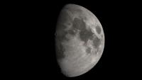
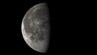
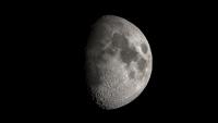
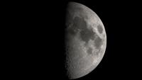
Finally figured out self shadowing terrain that I've been struggling with for a while... a couple of what I THINK are realistic renders, plus one with UBER-EXAGER-TERRAIN and a final one that's exagerated, but only to look a bit more realistic. It seems I have to turn up above and beyond what I'd expect the numbers to require for realistic terrain - perhaps because of the comparatively low level of detail in the terrain models.
And because the resolution isn't that good - a bit of foreshortening to get a look at Eddington for Stu
Attached thumbnail(s)
|
|||||
|
|
|
|||||
 elakdawalla First public release of Kaguya data Nov 2 2009, 05:07 AM
 djellison First thing I wanted was TOPO data - and managed t... Nov 2 2009, 08:16 AM akuo Are they going to release the actual HD camera dat... Nov 2 2009, 10:51 AM djellison That's copyrighted by the broadcast company th... Nov 2 2009, 11:44 AM Phil Stooke I'm registered but I haven't figured it ou... Nov 2 2009, 02:32 PM Phil Stooke OK, getting somewhere... if you run the 3D Moon Ja... Nov 2 2009, 02:54 PM
 djellison QUOTE (Phil Stooke @ Nov 2 2009, 02:54 PM... Nov 9 2009, 07:56 PM mhoward I'm downloading the elevation data (at least I... Nov 2 2009, 09:12 PM Phil Stooke --- still struggling with the format. My image ap... Nov 2 2009, 10:50 PM elakdawalla I'm glad you're slogging through this and ... Nov 2 2009, 11:09 PM djellison Well - I managed to look at the resulting file - a... Nov 2 2009, 11:24 PM mhoward QUOTE (djellison @ Nov 2 2009, 04:24 PM) ... Nov 2 2009, 11:49 PM mhoward P.S. For the images - I haven't looked at thos... Nov 2 2009, 11:57 PM Bjorn Jonsson QUOTE (mhoward @ Nov 2 2009, 11:57 PM) P.... Nov 3 2009, 01:22 AM JohnVV finally i can get ride of my "artists concept... Nov 3 2009, 12:09 AM mhoward I'm going to have to go out to dinner pretty s... Nov 3 2009, 12:17 AM Phil Stooke IMG2PNG can't do it as it is. The problem mig... Nov 3 2009, 01:50 AM djellison The best analogy I can come up with is the values ... Nov 3 2009, 08:57 AM JohnVV i just looked at LALT_GGT_NUM.TAB in ghex edit
se... Nov 3 2009, 09:32 AM djellison As text loaded straight into ImageJ - it's lat... Nov 3 2009, 10:25 AM djellison Thanks to mhoward's processing and my running ... Nov 3 2009, 06:48 PM claurel QUOTE (djellison @ Nov 3 2009, 10:48 AM) ... Nov 3 2009, 07:50 PM mhoward Also, something we've been waiting for for a l... Nov 3 2009, 07:05 PM volcanopele These Celestia screenshots use mhoward's regul... Nov 3 2009, 07:09 PM mhoward My cellphone probably can't compete with stuff... Nov 3 2009, 07:24 PM JohnVV for celestia you might want to run the 16bit tiff ... Nov 3 2009, 07:27 PM mhoward QUOTE (JohnVV @ Nov 3 2009, 12:27 PM) for... Nov 3 2009, 07:39 PM claurel QUOTE (mhoward @ Nov 3 2009, 11:39 AM) If... Nov 3 2009, 07:48 PM mhoward P.S. If anybody prefers raw 16-bit binary integer ... Nov 3 2009, 07:44 PM mhoward Thanks, Chris. I've got the sine of the latitu... Nov 3 2009, 07:56 PM volcanopele Here are a few more screenshots:
And rotation ... Nov 3 2009, 09:25 PM mhoward Awesome movie.
Now that I'm working with the ... Nov 3 2009, 09:48 PM claurel QUOTE (mhoward @ Nov 3 2009, 01:48 PM) No... Nov 4 2009, 02:20 AM mhoward QUOTE (claurel @ Nov 3 2009, 07:20 PM) Yo... Nov 4 2009, 04:12 PM Bjorn Jonsson Having this DEM is awesome, for the first time I... Nov 3 2009, 11:43 PM Phil Stooke Outstanding! The DEM is indeed a wonderful pr... Nov 4 2009, 01:58 AM JohnVV i just made a normal with my hacked copy of nms ( ... Nov 4 2009, 02:44 AM JohnVV two screen shots
the first one is the NEW one at ... Nov 4 2009, 03:58 AM Phil Stooke "probably my best so far" - yes, I'd... Nov 4 2009, 03:59 AM Stu Bjorn - absolutely stunning pics, thank you! ... Nov 4 2009, 06:26 AM SandiBandi Bjor (and JohnVV!) amazing work! Seeing ob... Nov 4 2009, 09:07 AM ugordan Outstanding work, Bjorn!
This may be the fir... Nov 4 2009, 11:50 AM 4th rock from the sun It does look quite photographic ! Congratulat... Nov 4 2009, 03:05 PM Bjorn Jonsson QUOTE (ugordan @ Nov 4 2009, 11:50 AM) Ou... Nov 5 2009, 12:00 AM mhoward After adding the LALT normal map, I've been tw... Nov 4 2009, 04:21 PM nprev Quick, oh yes, but dirty....? Stunning. Nov 5 2009, 01:43 AM mhoward That's extraordinary, Bjorn.
Earlier today I... Nov 5 2009, 05:27 AM Stu These Kaguya-derived images are absolutely stunnin... Nov 5 2009, 10:11 PM ElkGroveDan I like the exaggerated one. Somehow on a globe it... Nov 5 2009, 10:23 PM S_Walker I wonder when we'll see the first program that... Nov 6 2009, 12:41 PM Jim Mosher QUOTE (S_Walker @ Nov 6 2009, 01:41 PM) I... Nov 21 2009, 08:43 PM mhoward For those of you wondering, as I was, which one is... Nov 6 2009, 03:26 PM djellison I had to look it up as well And S_Walker - the ... Nov 6 2009, 03:29 PM S_Walker QUOTE (djellison @ Nov 6 2009, 10:29 AM) ... Nov 6 2009, 05:39 PM djellison There's Google Earth/Moon/Mars Nov 6 2009, 06:07 PM mhoward QUOTE (djellison @ Nov 6 2009, 11:07 AM) ... Nov 6 2009, 06:13 PM S_Walker QUOTE (mhoward @ Nov 6 2009, 01:13 PM) I ... Nov 6 2009, 06:33 PM mhoward I see. Well as Doug points out, Moon Globe may wel... Nov 6 2009, 06:50 PM pch QUOTE (mhoward @ Nov 6 2009, 08:50 PM) Vi... Nov 7 2009, 01:13 PM claurel QUOTE (mhoward @ Nov 6 2009, 10:13 AM) Na... Nov 6 2009, 07:52 PM mhoward Thanks. I'm also a Celestia fan. Nov 6 2009, 08:20 PM JohnVV mhoward
there will be a hires add on for celestia ... Nov 6 2009, 10:09 PM djellison Exagerated rendering : http://www.youtube.com/watc... Nov 6 2009, 11:02 PM ugordan Oooh, exaggerated is right! Looks great. And k... Nov 7 2009, 12:22 AM Rick Sternbach My thanks to everyone who made the 16-bit grayscal... Nov 7 2009, 02:33 AM claurel Joining in the spinning Moon video party... Here... Nov 7 2009, 04:26 AM FordPrefect Fantastic Work everyone! I've been hoping ... Nov 7 2009, 10:36 AM JohnVV For the past 1 1/2 days i have been trying to get ... Nov 7 2009, 05:22 AM mhoward Not just a movie party - a lunar software conventi... Nov 8 2009, 05:20 PM claurel Has anyone else noticed a slight misalignment betw... Nov 8 2009, 08:26 PM mhoward QUOTE (claurel @ Nov 8 2009, 02:26 PM) Ha... Nov 9 2009, 08:17 PM Phil Stooke Map control from altimeters is much better than th... Nov 8 2009, 08:40 PM claurel QUOTE (Phil Stooke @ Nov 8 2009, 12:40 PM... Nov 9 2009, 07:16 PM Phil Stooke Clem laser altimetry was such low resolution that ... Nov 9 2009, 09:09 PM mhoward QUOTE (Phil Stooke @ Nov 9 2009, 03:09 PM... Nov 9 2009, 09:24 PM claurel QUOTE (mhoward @ Nov 9 2009, 01:24 PM) Th... Nov 10 2009, 02:40 AM Michael Zeiler I downloaded the Kaguya LALT_GGT_NUM data set from... Nov 10 2009, 12:50 AM Carsten QUOTE (Michael Zeiler @ Nov 10 2009, 01:5... Nov 21 2009, 06:29 PM Michael Zeiler QUOTE (Carsten @ Nov 21 2009, 11:29 AM) R... Nov 22 2009, 04:43 AM Jim Mosher QUOTE (Michael Zeiler @ Nov 22 2009, 05:4... Nov 23 2009, 04:28 AM Michael Zeiler Another lunar hypsometric map, the near side of th... Nov 10 2009, 12:51 AM Michael Zeiler The far side of the moon. Nov 10 2009, 12:52 AM Michael Zeiler Here's the north pole perspective Nov 10 2009, 12:56 AM Michael Zeiler And the perspective above the south pole of the mo... Nov 10 2009, 01:01 AM JohnVV i used the "Clem_NIR_V0.1 " 5 band pds d... Nov 10 2009, 09:35 AM Bjorn Jonsson A decided to do a rotation movie. The "subspa... Nov 12 2009, 09:47 AM djellison Bit of fun turning the elevation map into a colour... Nov 14 2009, 11:25 PM stevesliva QUOTE (djellison @ Nov 14 2009, 06:25 PM)... Nov 15 2009, 05:48 PM mcgyver An italian guy here is looking for somebody able t... Nov 15 2009, 01:23 PM Jzmiller1 QUOTE (elakdawalla @ Nov 2 2009, 12:07 AM... Nov 15 2009, 06:09 PM djellison Things I try (usually in this order)
NASAView
Ima... Nov 15 2009, 06:42 PM JohnVV QUOTE I've downloaded some data from the SELEN... Nov 16 2009, 07:42 AM mhoward Just to join the rotation movie party: Moon Globe ... Nov 17 2009, 05:35 PM Jzmiller1 I finally got my copy of ENVI running. Opening th... Nov 18 2009, 12:41 AM kwan3217 I don't know if this is well known or not, but... Nov 18 2009, 08:09 PM Jim Mosher QUOTE (kwan3217 @ Nov 18 2009, 09:09 PM) ... Nov 20 2009, 09:03 PM mhoward Here's a better Moon Globe rotation movie at a... Nov 19 2009, 01:25 AM JohnVV as to the high and low points i have been finding ... Nov 19 2009, 07:23 AM Phil Stooke Your maps are very nice indeed, Michael.
Appare... Nov 22 2009, 01:27 PM
djellison QUOTE (Phil Stooke @ Nov 2 2009, 02:54 PM... Nov 9 2009, 07:56 PM mhoward I'm downloading the elevation data (at least I... Nov 2 2009, 09:12 PM Phil Stooke --- still struggling with the format. My image ap... Nov 2 2009, 10:50 PM elakdawalla I'm glad you're slogging through this and ... Nov 2 2009, 11:09 PM djellison Well - I managed to look at the resulting file - a... Nov 2 2009, 11:24 PM mhoward QUOTE (djellison @ Nov 2 2009, 04:24 PM) ... Nov 2 2009, 11:49 PM mhoward P.S. For the images - I haven't looked at thos... Nov 2 2009, 11:57 PM Bjorn Jonsson QUOTE (mhoward @ Nov 2 2009, 11:57 PM) P.... Nov 3 2009, 01:22 AM JohnVV finally i can get ride of my "artists concept... Nov 3 2009, 12:09 AM mhoward I'm going to have to go out to dinner pretty s... Nov 3 2009, 12:17 AM Phil Stooke IMG2PNG can't do it as it is. The problem mig... Nov 3 2009, 01:50 AM djellison The best analogy I can come up with is the values ... Nov 3 2009, 08:57 AM JohnVV i just looked at LALT_GGT_NUM.TAB in ghex edit
se... Nov 3 2009, 09:32 AM djellison As text loaded straight into ImageJ - it's lat... Nov 3 2009, 10:25 AM djellison Thanks to mhoward's processing and my running ... Nov 3 2009, 06:48 PM claurel QUOTE (djellison @ Nov 3 2009, 10:48 AM) ... Nov 3 2009, 07:50 PM mhoward Also, something we've been waiting for for a l... Nov 3 2009, 07:05 PM volcanopele These Celestia screenshots use mhoward's regul... Nov 3 2009, 07:09 PM mhoward My cellphone probably can't compete with stuff... Nov 3 2009, 07:24 PM JohnVV for celestia you might want to run the 16bit tiff ... Nov 3 2009, 07:27 PM mhoward QUOTE (JohnVV @ Nov 3 2009, 12:27 PM) for... Nov 3 2009, 07:39 PM claurel QUOTE (mhoward @ Nov 3 2009, 11:39 AM) If... Nov 3 2009, 07:48 PM mhoward P.S. If anybody prefers raw 16-bit binary integer ... Nov 3 2009, 07:44 PM mhoward Thanks, Chris. I've got the sine of the latitu... Nov 3 2009, 07:56 PM volcanopele Here are a few more screenshots:
And rotation ... Nov 3 2009, 09:25 PM mhoward Awesome movie.
Now that I'm working with the ... Nov 3 2009, 09:48 PM claurel QUOTE (mhoward @ Nov 3 2009, 01:48 PM) No... Nov 4 2009, 02:20 AM mhoward QUOTE (claurel @ Nov 3 2009, 07:20 PM) Yo... Nov 4 2009, 04:12 PM Bjorn Jonsson Having this DEM is awesome, for the first time I... Nov 3 2009, 11:43 PM Phil Stooke Outstanding! The DEM is indeed a wonderful pr... Nov 4 2009, 01:58 AM JohnVV i just made a normal with my hacked copy of nms ( ... Nov 4 2009, 02:44 AM JohnVV two screen shots
the first one is the NEW one at ... Nov 4 2009, 03:58 AM Phil Stooke "probably my best so far" - yes, I'd... Nov 4 2009, 03:59 AM Stu Bjorn - absolutely stunning pics, thank you! ... Nov 4 2009, 06:26 AM SandiBandi Bjor (and JohnVV!) amazing work! Seeing ob... Nov 4 2009, 09:07 AM ugordan Outstanding work, Bjorn!
This may be the fir... Nov 4 2009, 11:50 AM 4th rock from the sun It does look quite photographic ! Congratulat... Nov 4 2009, 03:05 PM Bjorn Jonsson QUOTE (ugordan @ Nov 4 2009, 11:50 AM) Ou... Nov 5 2009, 12:00 AM mhoward After adding the LALT normal map, I've been tw... Nov 4 2009, 04:21 PM nprev Quick, oh yes, but dirty....? Stunning. Nov 5 2009, 01:43 AM mhoward That's extraordinary, Bjorn.
Earlier today I... Nov 5 2009, 05:27 AM Stu These Kaguya-derived images are absolutely stunnin... Nov 5 2009, 10:11 PM ElkGroveDan I like the exaggerated one. Somehow on a globe it... Nov 5 2009, 10:23 PM S_Walker I wonder when we'll see the first program that... Nov 6 2009, 12:41 PM Jim Mosher QUOTE (S_Walker @ Nov 6 2009, 01:41 PM) I... Nov 21 2009, 08:43 PM mhoward For those of you wondering, as I was, which one is... Nov 6 2009, 03:26 PM djellison I had to look it up as well And S_Walker - the ... Nov 6 2009, 03:29 PM S_Walker QUOTE (djellison @ Nov 6 2009, 10:29 AM) ... Nov 6 2009, 05:39 PM djellison There's Google Earth/Moon/Mars Nov 6 2009, 06:07 PM mhoward QUOTE (djellison @ Nov 6 2009, 11:07 AM) ... Nov 6 2009, 06:13 PM S_Walker QUOTE (mhoward @ Nov 6 2009, 01:13 PM) I ... Nov 6 2009, 06:33 PM mhoward I see. Well as Doug points out, Moon Globe may wel... Nov 6 2009, 06:50 PM pch QUOTE (mhoward @ Nov 6 2009, 08:50 PM) Vi... Nov 7 2009, 01:13 PM claurel QUOTE (mhoward @ Nov 6 2009, 10:13 AM) Na... Nov 6 2009, 07:52 PM mhoward Thanks. I'm also a Celestia fan. Nov 6 2009, 08:20 PM JohnVV mhoward
there will be a hires add on for celestia ... Nov 6 2009, 10:09 PM djellison Exagerated rendering : http://www.youtube.com/watc... Nov 6 2009, 11:02 PM ugordan Oooh, exaggerated is right! Looks great. And k... Nov 7 2009, 12:22 AM Rick Sternbach My thanks to everyone who made the 16-bit grayscal... Nov 7 2009, 02:33 AM claurel Joining in the spinning Moon video party... Here... Nov 7 2009, 04:26 AM FordPrefect Fantastic Work everyone! I've been hoping ... Nov 7 2009, 10:36 AM JohnVV For the past 1 1/2 days i have been trying to get ... Nov 7 2009, 05:22 AM mhoward Not just a movie party - a lunar software conventi... Nov 8 2009, 05:20 PM claurel Has anyone else noticed a slight misalignment betw... Nov 8 2009, 08:26 PM mhoward QUOTE (claurel @ Nov 8 2009, 02:26 PM) Ha... Nov 9 2009, 08:17 PM Phil Stooke Map control from altimeters is much better than th... Nov 8 2009, 08:40 PM claurel QUOTE (Phil Stooke @ Nov 8 2009, 12:40 PM... Nov 9 2009, 07:16 PM Phil Stooke Clem laser altimetry was such low resolution that ... Nov 9 2009, 09:09 PM mhoward QUOTE (Phil Stooke @ Nov 9 2009, 03:09 PM... Nov 9 2009, 09:24 PM claurel QUOTE (mhoward @ Nov 9 2009, 01:24 PM) Th... Nov 10 2009, 02:40 AM Michael Zeiler I downloaded the Kaguya LALT_GGT_NUM data set from... Nov 10 2009, 12:50 AM Carsten QUOTE (Michael Zeiler @ Nov 10 2009, 01:5... Nov 21 2009, 06:29 PM Michael Zeiler QUOTE (Carsten @ Nov 21 2009, 11:29 AM) R... Nov 22 2009, 04:43 AM Jim Mosher QUOTE (Michael Zeiler @ Nov 22 2009, 05:4... Nov 23 2009, 04:28 AM Michael Zeiler Another lunar hypsometric map, the near side of th... Nov 10 2009, 12:51 AM Michael Zeiler The far side of the moon. Nov 10 2009, 12:52 AM Michael Zeiler Here's the north pole perspective Nov 10 2009, 12:56 AM Michael Zeiler And the perspective above the south pole of the mo... Nov 10 2009, 01:01 AM JohnVV i used the "Clem_NIR_V0.1 " 5 band pds d... Nov 10 2009, 09:35 AM Bjorn Jonsson A decided to do a rotation movie. The "subspa... Nov 12 2009, 09:47 AM djellison Bit of fun turning the elevation map into a colour... Nov 14 2009, 11:25 PM stevesliva QUOTE (djellison @ Nov 14 2009, 06:25 PM)... Nov 15 2009, 05:48 PM mcgyver An italian guy here is looking for somebody able t... Nov 15 2009, 01:23 PM Jzmiller1 QUOTE (elakdawalla @ Nov 2 2009, 12:07 AM... Nov 15 2009, 06:09 PM djellison Things I try (usually in this order)
NASAView
Ima... Nov 15 2009, 06:42 PM JohnVV QUOTE I've downloaded some data from the SELEN... Nov 16 2009, 07:42 AM mhoward Just to join the rotation movie party: Moon Globe ... Nov 17 2009, 05:35 PM Jzmiller1 I finally got my copy of ENVI running. Opening th... Nov 18 2009, 12:41 AM kwan3217 I don't know if this is well known or not, but... Nov 18 2009, 08:09 PM Jim Mosher QUOTE (kwan3217 @ Nov 18 2009, 09:09 PM) ... Nov 20 2009, 09:03 PM mhoward Here's a better Moon Globe rotation movie at a... Nov 19 2009, 01:25 AM JohnVV as to the high and low points i have been finding ... Nov 19 2009, 07:23 AM Phil Stooke Your maps are very nice indeed, Michael.
Appare... Nov 22 2009, 01:27 PM |

|
Lo-Fi Version | Time is now: 20th September 2024 - 01:08 PM |
|
RULES AND GUIDELINES Please read the Forum Rules and Guidelines before posting. IMAGE COPYRIGHT |
OPINIONS AND MODERATION Opinions expressed on UnmannedSpaceflight.com are those of the individual posters and do not necessarily reflect the opinions of UnmannedSpaceflight.com or The Planetary Society. The all-volunteer UnmannedSpaceflight.com moderation team is wholly independent of The Planetary Society. The Planetary Society has no influence over decisions made by the UnmannedSpaceflight.com moderators. |
SUPPORT THE FORUM Unmannedspaceflight.com is funded by the Planetary Society. Please consider supporting our work and many other projects by donating to the Society or becoming a member. |
|