High-Res DEMs from single HiRISE images, First results of new "Shape from Shading" algorithm |

High-Res DEMs from single HiRISE images, First results of new "Shape from Shading" algorithm |
 Jan 16 2010, 03:30 PM Jan 16 2010, 03:30 PM
Post
#1
|
|
|
Member  Group: Members Posts: 713 Joined: 30-March 05 Member No.: 223 |
Hi all,
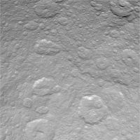
Here the long overdue continuation of the "Alien Landscapes" series. This time based on 3D DEMs generated with "Shape from Shading" from single HiRISE images. Enjoy  Click on Images for larger version. Detail views from PSP_002172_1410 (large gully system)   Detail view of Gullies from PSP_001376_1675   Detail of gully system in PSP_002022_1455  Dune Views from PSP_004339_1890   Detail from PSP_001834_1605   Here is some background info on the making of the images: "Shape from Shading" (SFS) i.e. the possibility to extract shape information from a single image has always been a fascinating topic for me. Now I found the time to implement a prototype for a new SFS algorithm based on some ideas that I've been thinking about for a long time. The problem with existing SFS approaches (see here for a survey is that they either tend to over-smooth the details (due to the regularization constraint) or suffer from excessive noise in the high-frequency components of the reconstructed surface. Another problem is the large demand on CPU ressources which would make them very challenging to apply to large scale input data, such as HiRISE orbiter images. So for a long time I was rather sceptical as to the potential of SFS and it was my impression that Methods based on multiple images (stereo) must be far superior to single-image SFS. However, after a long time of experimenting, combining existing approaches with some new ideas, I got the following quite promising first results that I'd like to share: All of the images were generated from a single HiRISE image (no depth information was used from stereo or laser altimeter data). Also, no texturing or additional coloring/shading was applied when rendering the surface. Every detail visible is real 3D down to the pixel-level... For rendering I used a very simple model based on lambertian reflection with gouraud shading. The resolution of the images is still moderate: that is downsampled details crops in the order of 0.5-1 Megapixels. However, despite the heavy math machinery that drives the core of the algoritm (several systems of equations with millions of unknowns) the processing time is still moderate (about 15 Minutes per med-res image, using about 2 Gigs main mem) such that the application to full-res HiRISE images should be possible The following image shows an example to illustrate the general principle (click to enlarge).  On the left hand side the 2D input image (simple noisy JPEG from the Web with unknwon light source direction). On the right hand side shows the recovered 3D surface re-lighted under a different light source direction. Note that one problem of the current implementation of the algorithm is it's vulnerability to notable distortions in the low frequency components (i.e. large scale variations) of the generated surface. However I'm confident that this can be overcome by an improved version or by adding the large-scale depth information from stereo-based DEMs or altimeter data (MOLA) where available. |
 |
 
|
 |
|
Jan 19 2010, 11:05 PM
Post
#2
|
|||
 IMG to PNG GOD Group: Moderator Posts: 2254 Joined: 19-February 04 From: Near fire and ice Member No.: 38 |
There are lots and lots of things I'd be interested in testing but I'm posting just a single image to test if it's not too much trouble. What I'm posting here has been carefully selected to ensure I shouldn't have to post more stuff to test, at least not in the near term (although testing how the SFS software performs with the sun almost directly overhead would be interesting as well, my stereomatcher performs poorly in that case for obvious reasons).
This is a Cassini image of Rhea with the Tirawa impact basin partially visible in the upper right quadrant:
I would be very interested in seeing a DEM from this image. What would be most interesting, if possible, would be a 1024x1024 pixel 16 bit grayscale DEM as a tiff or png file. If this is possible I'll attempt to merge it into my global DEM of Rhea that I made using stereo pairs. That would combine the best of both worlds and I would post the results here. Otherwise some test renders would be nice. This is a portion of my DEM of Rhea showing most of the image above (it's slightly cropped):
Here black represents -6.320 km and white 6.176 km relative to an ellipsoid. Unlike the Cassini image above, this 'image' is in simple cylindrical projection and covers longitude 150.25 to 187.875 degrees and latitude 8.625 to 41.625 degrees (including the black stuff surrounding the DEM). |
||
|
|
|
||
Nirgal High-Res DEMs from single HiRISE images Jan 16 2010, 03:30 PM lyford WOAH!
I want to climb those dunes..... am... Jan 16 2010, 04:29 PM mhoward Mind-blowing. Jan 16 2010, 05:03 PM cbcnasa The images are just amazing, fantastic job. Jan 16 2010, 05:48 PM jamescanvin Those are just astonishing Bernhard, great work... Jan 16 2010, 06:05 PM ElkGroveDan Amazing and beautiful stuff, as always. I don... Jan 16 2010, 06:39 PM eoincampbell Another UMSF classic, it's truly a joy to come... Jan 16 2010, 07:13 PM PDP8E Bernhard,
This is fabulous progress report!
I... Jan 16 2010, 07:43 PM djellison O
M
F
G Jan 16 2010, 08:20 PM Tesheiner Unbelievable!!!
I want to climb one... Jan 16 2010, 08:36 PM Bjorn Jonsson In a word:
WOW!!!
Are you draping th... Jan 16 2010, 09:09 PM
lyford WOAH!
I want to climb those dunes..... am... Jan 16 2010, 04:29 PM mhoward Mind-blowing. Jan 16 2010, 05:03 PM cbcnasa The images are just amazing, fantastic job. Jan 16 2010, 05:48 PM jamescanvin Those are just astonishing Bernhard, great work... Jan 16 2010, 06:05 PM ElkGroveDan Amazing and beautiful stuff, as always. I don... Jan 16 2010, 06:39 PM eoincampbell Another UMSF classic, it's truly a joy to come... Jan 16 2010, 07:13 PM PDP8E Bernhard,
This is fabulous progress report!
I... Jan 16 2010, 07:43 PM djellison O
M
F
G Jan 16 2010, 08:20 PM Tesheiner Unbelievable!!!
I want to climb one... Jan 16 2010, 08:36 PM Bjorn Jonsson In a word:
WOW!!!
Are you draping th... Jan 16 2010, 09:09 PM
 Nirgal QUOTE (Bjorn Jonsson @ Jan 16 2010, 10:09... Jan 16 2010, 10:27 PM Stu QUOTE (Nirgal @ Jan 16 2010, 10:27 PM) P.... Jan 16 2010, 10:29 PM Bjorn Jonsson QUOTE (Nirgal @ Jan 16 2010, 10:27 PM) Th... Jan 16 2010, 11:07 PM Nirgal QUOTE (Bjorn Jonsson @ Jan 17 2010, 12:07... Jan 16 2010, 11:16 PM ngunn QUOTE (Nirgal @ Jan 16 2010, 11:16 PM) no... Jan 17 2010, 10:18 AM Nirgal QUOTE (ngunn @ Jan 17 2010, 11:18 AM) Exc... Jan 17 2010, 12:25 PM ElkGroveDan And for an Earthly analog here is the Emperor Face... Jan 17 2010, 06:09 PM Nirgal QUOTE (ElkGroveDan @ Jan 17 2010, 07:09 P... Jan 18 2010, 01:15 PM Reckless Brilliant Bernhard
As I was looking at those pic... Jan 16 2010, 09:25 PM nprev Just freakin' amazing, is all! What immedi... Jan 16 2010, 09:32 PM ngunn Me too. I always prefer to see landscapes without ... Jan 16 2010, 10:49 PM nprev ...how sedimentary can you get? Jan 16 2010, 11:26 PM djellison If you want a good test - try the Pathfinder obser... Jan 17 2010, 03:14 PM imipak ...what everyone else has said!
I know very l... Jan 17 2010, 07:17 PM Nirgal QUOTE (imipak @ Jan 17 2010, 08:17 PM) ..... Jan 18 2010, 10:26 AM sgendreau QUOTE (Nirgal @ Jan 18 2010, 02:26 AM) I ... Jan 18 2010, 04:27 PM vikingmars Bernhard, your work is "estupendo" ... Jan 18 2010, 02:49 PM climber Bernhard, after Olivier's statement, knowing w... Jan 18 2010, 05:20 PM PDP8E Bernhard,
What could your technique do with a fair... Jan 18 2010, 08:42 PM Bjorn Jonsson Earlier in this thread I mentioned Enceladus and E... Jan 19 2010, 01:00 AM Nirgal QUOTE (Bjorn Jonsson @ Jan 19 2010, 02:00... Jan 19 2010, 03:43 PM djellison OK - yeah - do you think you'll be able to sha... Jan 19 2010, 04:19 PM Bjorn Jonsson QUOTE (Nirgal @ Jan 19 2010, 03:43 PM) ok... Jan 19 2010, 05:37 PM djellison Things I want to try ( in no particular order )
T... Jan 19 2010, 05:47 PM vikingmars QUOTE (djellison @ Jan 19 2010, 06:47 PM)... Jan 20 2010, 08:37 AM mcaplinger Not to be dismissive of this, but as Nirgal pointe... Jan 19 2010, 06:23 PM Nirgal QUOTE (mcaplinger @ Jan 19 2010, 07:23 PM... Jan 19 2010, 09:27 PM ElkGroveDan Since we have a lot of examples of places with ver... Jan 19 2010, 06:38 PM Ant103 ASTOUNDING ! AMAZING ! You just did a WOND... Jan 19 2010, 09:30 PM Stu You keep sharing your "pretty visualisations... Jan 19 2010, 09:35 PM 4th rock from the sun I'd VERY much like to produce a detailed DEM f... Jan 20 2010, 10:09 AM mcaplinger QUOTE (4th rock from the sun @ Jan 20 2010, 0... Jan 20 2010, 02:19 PM djellison I'm not sure this would work on Radar. Jan 20 2010, 01:56 PM 4th rock from the sun It should work on radar, as there's the concep... Jan 20 2010, 02:13 PM imipak *cough* Titan..? (Edit - sorry, I didn't spot ... Jan 20 2010, 02:42 PM elakdawalla The software wouldn't work on radar images wit... Jan 20 2010, 07:30 PM mcaplinger QUOTE (elakdawalla @ Jan 20 2010, 11:30 A... Jan 20 2010, 07:56 PM vikingmars Bernhard, just an idea...
Because this 3D HI-Res D... Jan 20 2010, 08:38 PM Nirgal QUOTE (vikingmars @ Jan 20 2010, 09:38 PM... Jan 20 2010, 09:30 PM Bjorn Jonsson As should already be obvious I'm very interest... Jan 21 2010, 12:56 AM 4th rock from the sun Thanks for sharing your insights into the photocli... Jan 20 2010, 08:43 PM climber I'm wondering if you (Bernhard) can run your s... Jan 21 2010, 10:07 PM Phil Stooke It can't be done on that image, it would have ... Jan 22 2010, 12:32 PM Nirgal QUOTE (Phil Stooke @ Jan 22 2010, 01:32 P... Jan 22 2010, 03:40 PM djellison Two for the columbia hills are listed within this ... Jan 22 2010, 03:59 PM Nirgal QUOTE (djellison @ Jan 22 2010, 04:59 PM)... Jan 23 2010, 04:00 PM ngunn Nirgal, I can't find your original thread so I... Mar 1 2010, 10:08 PM Nirgal QUOTE (ngunn @ Mar 1 2010, 11:08 PM) Nirg... Mar 1 2010, 10:36 PM ngunn No I don't, unfortunately. Go to the 'Ende... Mar 1 2010, 10:57 PM Tesheiner AFAIK, that's the non-map-projected version of... Mar 2 2010, 06:52 AM Nirgal Upon a request posed over at the "Dust Avalan... Mar 2 2010, 08:44 PM tdemko This area has fascinated me for a while and Nirgal... Mar 3 2010, 11:15 AM ngunn QUOTE (tdemko @ Mar 3 2010, 11:15 AM) The... Mar 3 2010, 12:57 PM Nirgal QUOTE (ngunn @ Mar 3 2010, 01:57 PM) Fasc... Mar 3 2010, 03:27 PM ElkGroveDan QUOTE (tdemko @ Mar 3 2010, 03:15 AM) Thi... Mar 3 2010, 02:32 PM ngunn YES!! Now that is everything I'd hoped... Mar 2 2010, 09:03 PM Nirgal QUOTE (ngunn @ Mar 2 2010, 10:03 PM) Can ... Mar 2 2010, 09:33 PM Tesheiner Incredible!
BTW, I think we'll have to sa... Mar 2 2010, 09:06 PM Floyd A question for Tim and Nirgal: This is one of the... Mar 3 2010, 02:33 PM ngunn Zoomable CTX of the area:
http://global-data.mars.... Mar 3 2010, 02:58 PM Nirgal QUOTE (ngunn @ Mar 3 2010, 03:58 PM) Look... Mar 4 2010, 08:06 AM Nirgal For comparison, here is (a crop of) the original, ... Mar 3 2010, 06:37 PM Julius To me it looks like an' island' which even... Mar 3 2010, 07:11 PM ngunn Again, greatly appreciated Nirgal. Those ones show... Mar 4 2010, 09:26 AM ngunn Nirgal, on closer inspection I'm having troubl... Mar 4 2010, 02:19 PM Nirgal QUOTE (ngunn @ Mar 4 2010, 03:19 PM) Nirg... Mar 4 2010, 03:57 PM
Nirgal QUOTE (Bjorn Jonsson @ Jan 16 2010, 10:09... Jan 16 2010, 10:27 PM Stu QUOTE (Nirgal @ Jan 16 2010, 10:27 PM) P.... Jan 16 2010, 10:29 PM Bjorn Jonsson QUOTE (Nirgal @ Jan 16 2010, 10:27 PM) Th... Jan 16 2010, 11:07 PM Nirgal QUOTE (Bjorn Jonsson @ Jan 17 2010, 12:07... Jan 16 2010, 11:16 PM ngunn QUOTE (Nirgal @ Jan 16 2010, 11:16 PM) no... Jan 17 2010, 10:18 AM Nirgal QUOTE (ngunn @ Jan 17 2010, 11:18 AM) Exc... Jan 17 2010, 12:25 PM ElkGroveDan And for an Earthly analog here is the Emperor Face... Jan 17 2010, 06:09 PM Nirgal QUOTE (ElkGroveDan @ Jan 17 2010, 07:09 P... Jan 18 2010, 01:15 PM Reckless Brilliant Bernhard
As I was looking at those pic... Jan 16 2010, 09:25 PM nprev Just freakin' amazing, is all! What immedi... Jan 16 2010, 09:32 PM ngunn Me too. I always prefer to see landscapes without ... Jan 16 2010, 10:49 PM nprev ...how sedimentary can you get? Jan 16 2010, 11:26 PM djellison If you want a good test - try the Pathfinder obser... Jan 17 2010, 03:14 PM imipak ...what everyone else has said!
I know very l... Jan 17 2010, 07:17 PM Nirgal QUOTE (imipak @ Jan 17 2010, 08:17 PM) ..... Jan 18 2010, 10:26 AM sgendreau QUOTE (Nirgal @ Jan 18 2010, 02:26 AM) I ... Jan 18 2010, 04:27 PM vikingmars Bernhard, your work is "estupendo" ... Jan 18 2010, 02:49 PM climber Bernhard, after Olivier's statement, knowing w... Jan 18 2010, 05:20 PM PDP8E Bernhard,
What could your technique do with a fair... Jan 18 2010, 08:42 PM Bjorn Jonsson Earlier in this thread I mentioned Enceladus and E... Jan 19 2010, 01:00 AM Nirgal QUOTE (Bjorn Jonsson @ Jan 19 2010, 02:00... Jan 19 2010, 03:43 PM djellison OK - yeah - do you think you'll be able to sha... Jan 19 2010, 04:19 PM Bjorn Jonsson QUOTE (Nirgal @ Jan 19 2010, 03:43 PM) ok... Jan 19 2010, 05:37 PM djellison Things I want to try ( in no particular order )
T... Jan 19 2010, 05:47 PM vikingmars QUOTE (djellison @ Jan 19 2010, 06:47 PM)... Jan 20 2010, 08:37 AM mcaplinger Not to be dismissive of this, but as Nirgal pointe... Jan 19 2010, 06:23 PM Nirgal QUOTE (mcaplinger @ Jan 19 2010, 07:23 PM... Jan 19 2010, 09:27 PM ElkGroveDan Since we have a lot of examples of places with ver... Jan 19 2010, 06:38 PM Ant103 ASTOUNDING ! AMAZING ! You just did a WOND... Jan 19 2010, 09:30 PM Stu You keep sharing your "pretty visualisations... Jan 19 2010, 09:35 PM 4th rock from the sun I'd VERY much like to produce a detailed DEM f... Jan 20 2010, 10:09 AM mcaplinger QUOTE (4th rock from the sun @ Jan 20 2010, 0... Jan 20 2010, 02:19 PM djellison I'm not sure this would work on Radar. Jan 20 2010, 01:56 PM 4th rock from the sun It should work on radar, as there's the concep... Jan 20 2010, 02:13 PM imipak *cough* Titan..? (Edit - sorry, I didn't spot ... Jan 20 2010, 02:42 PM elakdawalla The software wouldn't work on radar images wit... Jan 20 2010, 07:30 PM mcaplinger QUOTE (elakdawalla @ Jan 20 2010, 11:30 A... Jan 20 2010, 07:56 PM vikingmars Bernhard, just an idea...
Because this 3D HI-Res D... Jan 20 2010, 08:38 PM Nirgal QUOTE (vikingmars @ Jan 20 2010, 09:38 PM... Jan 20 2010, 09:30 PM Bjorn Jonsson As should already be obvious I'm very interest... Jan 21 2010, 12:56 AM 4th rock from the sun Thanks for sharing your insights into the photocli... Jan 20 2010, 08:43 PM climber I'm wondering if you (Bernhard) can run your s... Jan 21 2010, 10:07 PM Phil Stooke It can't be done on that image, it would have ... Jan 22 2010, 12:32 PM Nirgal QUOTE (Phil Stooke @ Jan 22 2010, 01:32 P... Jan 22 2010, 03:40 PM djellison Two for the columbia hills are listed within this ... Jan 22 2010, 03:59 PM Nirgal QUOTE (djellison @ Jan 22 2010, 04:59 PM)... Jan 23 2010, 04:00 PM ngunn Nirgal, I can't find your original thread so I... Mar 1 2010, 10:08 PM Nirgal QUOTE (ngunn @ Mar 1 2010, 11:08 PM) Nirg... Mar 1 2010, 10:36 PM ngunn No I don't, unfortunately. Go to the 'Ende... Mar 1 2010, 10:57 PM Tesheiner AFAIK, that's the non-map-projected version of... Mar 2 2010, 06:52 AM Nirgal Upon a request posed over at the "Dust Avalan... Mar 2 2010, 08:44 PM tdemko This area has fascinated me for a while and Nirgal... Mar 3 2010, 11:15 AM ngunn QUOTE (tdemko @ Mar 3 2010, 11:15 AM) The... Mar 3 2010, 12:57 PM Nirgal QUOTE (ngunn @ Mar 3 2010, 01:57 PM) Fasc... Mar 3 2010, 03:27 PM ElkGroveDan QUOTE (tdemko @ Mar 3 2010, 03:15 AM) Thi... Mar 3 2010, 02:32 PM ngunn YES!! Now that is everything I'd hoped... Mar 2 2010, 09:03 PM Nirgal QUOTE (ngunn @ Mar 2 2010, 10:03 PM) Can ... Mar 2 2010, 09:33 PM Tesheiner Incredible!
BTW, I think we'll have to sa... Mar 2 2010, 09:06 PM Floyd A question for Tim and Nirgal: This is one of the... Mar 3 2010, 02:33 PM ngunn Zoomable CTX of the area:
http://global-data.mars.... Mar 3 2010, 02:58 PM Nirgal QUOTE (ngunn @ Mar 3 2010, 03:58 PM) Look... Mar 4 2010, 08:06 AM Nirgal For comparison, here is (a crop of) the original, ... Mar 3 2010, 06:37 PM Julius To me it looks like an' island' which even... Mar 3 2010, 07:11 PM ngunn Again, greatly appreciated Nirgal. Those ones show... Mar 4 2010, 09:26 AM ngunn Nirgal, on closer inspection I'm having troubl... Mar 4 2010, 02:19 PM Nirgal QUOTE (ngunn @ Mar 4 2010, 03:19 PM) Nirg... Mar 4 2010, 03:57 PM |

|
Lo-Fi Version | Time is now: 26th September 2024 - 08:38 PM |
|
RULES AND GUIDELINES Please read the Forum Rules and Guidelines before posting. IMAGE COPYRIGHT |
OPINIONS AND MODERATION Opinions expressed on UnmannedSpaceflight.com are those of the individual posters and do not necessarily reflect the opinions of UnmannedSpaceflight.com or The Planetary Society. The all-volunteer UnmannedSpaceflight.com moderation team is wholly independent of The Planetary Society. The Planetary Society has no influence over decisions made by the UnmannedSpaceflight.com moderators. |
SUPPORT THE FORUM Unmannedspaceflight.com is funded by the Planetary Society. Please consider supporting our work and many other projects by donating to the Society or becoming a member. |
|