foldable map of Itokawa, a cook's tour of the sausage factory |

foldable map of Itokawa, a cook's tour of the sausage factory |
 Jan 23 2010, 03:39 AM Jan 23 2010, 03:39 AM
Post
#1
|
|||
|
Member  Group: Members Posts: 140 Joined: 20-November 07 Member No.: 3967 |
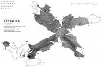
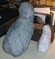
Not that I mean to compare Itokawa to a sausage, just to show you behind the scenes of making the map, along with the map itself, here, rather than continue to clog up the Hayabusa Return to Earth thread.
Here is the map itself, so far along as the pasting in of the mosaic has gone. And here is are two shots of the folded up map, compared with the computer-made model. Note the arrow to one of the "ears." The first try of the map failed to capture the ear, so I replotted the boundary, as seen in the Tracing image. All photos credit: Sara Adkins Studio
Attached thumbnail(s)
|
||
 |
 
|
||
 |
|
Jan 25 2010, 02:25 PM
Post
#2
|
||
|
Member Group: Members Posts: 140 Joined: 20-November 07 Member No.: 3967 |
"I'll see what I can find tomorrow."
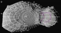
Phil, [EDIT, after Phil's last post] Oh. Nevermind. Maybe something will turn up in Houston. Can you produce the squares in something approximating the "high contrast" look of the cylindrical map? Can you produce the squares both with and without graticle lines? That way I can get a nice clean cut from the "without" square, and still use the "with" square to lock in the registration. And, if you've time for another request, can you use the Gaskell shape model to check my latitudes on Itokawa's chin? See the pic; the magenta lines are my guesses for the 23.333 and 26.667 latitudes. It's pretty tricky, because of the chin's extreme elongation, to locate where these latitudes emerge at the surface. Can you plot these for the areas I show? Some of my concern here (see the constant-scale natural boundary map) may be from pixel resolution. I had to stretch (enlarge) these squares by a factor of 5 from the cylindrical map. (At the poles, of course, the cylindrical map was way more pixels than I needed.) For most of the rest of the asteroid, the cylindrical map held about as many pixels as the corresponding area on the CSNB map. But under the chin, especially, higher resolution would make for a crisper image than what we've got so far. I've got to get hold of software that'll let me open and work with these digital shape models. Any suggestions?
Attached thumbnail(s)
|
|
|
|
|
|
 chuckclark foldable map of Itokawa Jan 23 2010, 03:39 AM
 chuckclark Okay, ran out of file space on that post. Here ar... Jan 23 2010, 03:42 AM chuckclark And here is a shot of the work lab where this all ... Jan 23 2010, 03:45 AM Phil Stooke Now that's what I call a workshop, Chuck! ... Jan 23 2010, 03:54 AM
 chuckclark Phil,
I'll have to expand the mosaic. Just of... Jan 24 2010, 07:39 PM chuckclark Well, so much for one more day. The mosaic has a ... Jan 24 2010, 07:56 PM Phil Stooke Very interesting, Chuck, and there is a good reaso... Jan 24 2010, 09:47 PM chuckclark QUOTE (Phil Stooke @ Jan 24 2010, 04:47 P... Jan 24 2010, 11:59 PM stevesliva Just wait until we find that Mobius-shaped asteroi... Jan 24 2010, 11:54 PM Phil Stooke I'll see what I can find tomorrow.
"Just... Jan 25 2010, 12:21 AM chuckclark "No - just a cylindrical projection with a tw... Jan 25 2010, 01:15 AM Phil Stooke This is primarily for Chuck, but I'll post it ... Jan 25 2010, 02:13 PM chuckclark Okay. that wasn't so difficult.
I took this i... Jan 25 2010, 08:11 PM chuckclark Here are the tabs I'm gonna try this time -- I... Feb 1 2010, 07:30 PM chuckclark Phil,
Can you remake the hi-contrast Itokawa cylin... Feb 8 2010, 05:18 PM Phil Stooke Hi Chuck - I just emailed it to you.
Phil Feb 8 2010, 05:46 PM chuckclark Okay. Three-fourths of the way put together. Her... Feb 11 2010, 02:28 AM nprev I am always amazed & deeply impressed by peopl... Feb 11 2010, 07:15 AM chuckclark QUOTE (nprev @ Feb 11 2010, 02:15 AM) I a... Feb 11 2010, 03:49 PM chuckclark Here's the group photo.
On the plastic model,... Feb 11 2010, 06:12 PM chuckclark Here's the last taping and folding sequence. ... Feb 16 2010, 02:07 PM chuckclark And to wrap up the tour -- everybody say cheese --... Feb 16 2010, 02:09 PM chuckclark And here's a beta version of conference handou... Feb 21 2010, 06:54 PM chuckclark So, on to the valley-bound map. This map organize... Feb 22 2010, 03:30 PM chuckclark And this is how the Valley "A" map looks... Feb 24 2010, 08:51 PM Phil Stooke Nic, Chuck! See you in Houston.
Phil Feb 24 2010, 11:59 PM chuckclark Oh, forgot to say, I didn't try to unscramble ... Feb 25 2010, 03:18 AM chuckclark Well, several misalignments in the graticles at th... Feb 25 2010, 11:07 PM chuckclark Here's the ridge-bound constant-scale natural ... Mar 14 2010, 10:26 PM chuckclark Here's a more interrupted valley-bound map, th... Oct 16 2010, 04:45 PM
chuckclark Phil,
I'll have to expand the mosaic. Just of... Jan 24 2010, 07:39 PM chuckclark Well, so much for one more day. The mosaic has a ... Jan 24 2010, 07:56 PM Phil Stooke Very interesting, Chuck, and there is a good reaso... Jan 24 2010, 09:47 PM chuckclark QUOTE (Phil Stooke @ Jan 24 2010, 04:47 P... Jan 24 2010, 11:59 PM stevesliva Just wait until we find that Mobius-shaped asteroi... Jan 24 2010, 11:54 PM Phil Stooke I'll see what I can find tomorrow.
"Just... Jan 25 2010, 12:21 AM chuckclark "No - just a cylindrical projection with a tw... Jan 25 2010, 01:15 AM Phil Stooke This is primarily for Chuck, but I'll post it ... Jan 25 2010, 02:13 PM chuckclark Okay. that wasn't so difficult.
I took this i... Jan 25 2010, 08:11 PM chuckclark Here are the tabs I'm gonna try this time -- I... Feb 1 2010, 07:30 PM chuckclark Phil,
Can you remake the hi-contrast Itokawa cylin... Feb 8 2010, 05:18 PM Phil Stooke Hi Chuck - I just emailed it to you.
Phil Feb 8 2010, 05:46 PM chuckclark Okay. Three-fourths of the way put together. Her... Feb 11 2010, 02:28 AM nprev I am always amazed & deeply impressed by peopl... Feb 11 2010, 07:15 AM chuckclark QUOTE (nprev @ Feb 11 2010, 02:15 AM) I a... Feb 11 2010, 03:49 PM chuckclark Here's the group photo.
On the plastic model,... Feb 11 2010, 06:12 PM chuckclark Here's the last taping and folding sequence. ... Feb 16 2010, 02:07 PM chuckclark And to wrap up the tour -- everybody say cheese --... Feb 16 2010, 02:09 PM chuckclark And here's a beta version of conference handou... Feb 21 2010, 06:54 PM chuckclark So, on to the valley-bound map. This map organize... Feb 22 2010, 03:30 PM chuckclark And this is how the Valley "A" map looks... Feb 24 2010, 08:51 PM Phil Stooke Nic, Chuck! See you in Houston.
Phil Feb 24 2010, 11:59 PM chuckclark Oh, forgot to say, I didn't try to unscramble ... Feb 25 2010, 03:18 AM chuckclark Well, several misalignments in the graticles at th... Feb 25 2010, 11:07 PM chuckclark Here's the ridge-bound constant-scale natural ... Mar 14 2010, 10:26 PM chuckclark Here's a more interrupted valley-bound map, th... Oct 16 2010, 04:45 PM |

|
Lo-Fi Version | Time is now: 25th September 2024 - 12:04 AM |
|
RULES AND GUIDELINES Please read the Forum Rules and Guidelines before posting. IMAGE COPYRIGHT |
OPINIONS AND MODERATION Opinions expressed on UnmannedSpaceflight.com are those of the individual posters and do not necessarily reflect the opinions of UnmannedSpaceflight.com or The Planetary Society. The all-volunteer UnmannedSpaceflight.com moderation team is wholly independent of The Planetary Society. The Planetary Society has no influence over decisions made by the UnmannedSpaceflight.com moderators. |
SUPPORT THE FORUM Unmannedspaceflight.com is funded by the Planetary Society. Please consider supporting our work and many other projects by donating to the Society or becoming a member. |
|