Opportunity Route Map |

Opportunity Route Map |
 Feb 11 2005, 08:11 AM Feb 11 2005, 08:11 AM
Post
#1
|
||
 The Insider  Group: Members Posts: 669 Joined: 3-May 04 Member No.: 73 |
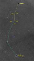
Here is an updated map of the road to Vostok.
Attached thumbnail(s)
|
|
 |
 
|
|
 |
| Guest_Oersted_* |
Mar 10 2010, 05:20 PM
Post
#2
|
|
Guests |
One day, when these missions are over, it would be great to have route maps showing all the tiny wiggles and turns of the actual rover movements instead of the "straight-line" representations in Tesheiner´s day-to-day updates. We have the data (hazcam pics) to draw in the actual micro-scale wiggly routes the rovers have taken. I am thinking of the slight deviations from straight lines that happen when dunes are crossed, when the navigation software works independently, etc.
|
|
|
|
 Pando Opportunity Route Map Feb 11 2005, 08:11 AM
 Tesheiner Here's a crop of the map with the latest data ... Oct 29 2009, 05:57 PM Hungry4info I've seen "70 m" and "steady pa... Oct 29 2009, 08:46 PM Tesheiner Bingo.
Enjoy! Oct 30 2009, 09:07 AM climber I could may be apply to be a Rover driver those da... Oct 30 2009, 01:43 PM Poolio Looks like about 50 meters on sol 2050? As usual,... Oct 31 2009, 12:50 AM Tesheiner Right at the money!
Here's my version.
Oct 31 2009, 09:24 AM
Tesheiner Here's a crop of the map with the latest data ... Oct 29 2009, 05:57 PM Hungry4info I've seen "70 m" and "steady pa... Oct 29 2009, 08:46 PM Tesheiner Bingo.
Enjoy! Oct 30 2009, 09:07 AM climber I could may be apply to be a Rover driver those da... Oct 30 2009, 01:43 PM Poolio Looks like about 50 meters on sol 2050? As usual,... Oct 31 2009, 12:50 AM Tesheiner Right at the money!
Here's my version.
Oct 31 2009, 09:24 AM
 ElkGroveDan I hadn't gone to Google Mars in a while. It l... Oct 31 2009, 01:43 PM SFJCody QUOTE (ElkGroveDan @ Oct 31 2009, 01:43 P... Oct 31 2009, 01:58 PM Tesheiner Wow, two map updates on the same day! (I wa... Oct 31 2009, 10:23 PM CosmicRocker QUOTE (SFJCody @ Oct 31 2009, 07:58 AM) .... Nov 1 2009, 02:44 AM SFJCody QUOTE (CosmicRocker @ Nov 1 2009, 02:44 A... Nov 1 2009, 09:32 AM Hungry4info QUOTE ("Tesheiner")Bingo. Enjoy! Lol... Nov 1 2009, 08:01 AM Tesheiner I saw just one route update after the first releas... Nov 1 2009, 12:28 PM Tesheiner Map update after sol 2054 and another 70m to the w... Nov 3 2009, 09:12 PM Tesheiner Update after sol 2056.
Nov 5 2009, 09:08 PM Tesheiner Sol 2058.
Nov 8 2009, 09:27 AM Tesheiner Here's the GE map version for sol 2061. The JP... Nov 11 2009, 10:46 AM Tesheiner Sol 2063.
Nov 13 2009, 09:28 AM jamescanvin Yestersol was sol B-2100 , time for another map up... Dec 21 2009, 10:48 AM kwp QUOTE (jamescanvin @ Dec 21 2009, 02:48 A... Jan 17 2010, 06:13 PM briv1016 Here you go.
http://www.msss.com/mars_images/moc/... Jan 17 2010, 06:28 PM Julius Whats the coloured representing?Topography or geol... Dec 21 2009, 05:09 PM alan The height of the ripples: red large ripples, gree... Dec 21 2009, 05:27 PM brellis Every 1000 times I want to say thank you, I feel c... Dec 22 2009, 04:51 AM Tesheiner Here's an update to the maps after sols 2122 a... Jan 14 2010, 09:35 AM Tesheiner Update after sol 2124, including the 19km mark.
Jan 14 2010, 11:06 PM Tesheiner Sol 2125.
And another milestone; we are 11km so... Jan 15 2010, 10:28 PM Nirgal 2021,2022,2023,2024 .... Soooo good to see her dri... Jan 17 2010, 04:57 PM djellison That happened a long time ago - and was notated as... Jan 17 2010, 06:17 PM centsworth_II Here's an annotated version with Endurance, Vi... Jan 17 2010, 06:45 PM fredk QUOTE (centsworth_II @ Jan 17 2010, 07:45... Jan 17 2010, 07:27 PM centsworth_II QUOTE (fredk @ Jan 17 2010, 02:27 PM) ...... Jan 17 2010, 08:30 PM kwp Using the Oppy+landing ellipse image for context (... Jan 19 2010, 05:55 PM antoniseb QUOTE (kwp @ Jan 19 2010, 12:55 PM) Using... Jan 20 2010, 05:29 PM imipak Talking of milestones, total odometry on reaching ... Jan 17 2010, 06:47 PM Tesheiner Here's my route map update after sol 2128.
Jan 19 2010, 09:17 AM climber We'll be there by week-end. Still driving in t... Jan 19 2010, 11:55 AM Tesheiner Map update for sol 2130.
Jan 20 2010, 09:48 PM Stu What do you think? 2 more drives and we're the... Jan 20 2010, 09:54 PM Tesheiner Yes. Jan 20 2010, 10:08 PM SFJCody Here's a google earth path for the predicted r... Jan 21 2010, 06:43 PM brellis hey SFJCody, I tried to download your MER-b map ex... Jan 21 2010, 07:53 PM SFJCody QUOTE (brellis @ Jan 21 2010, 07:53 PM) h... Jan 21 2010, 08:12 PM brellis Much appreciated. I get scared when my Google Mar... Jan 21 2010, 08:44 PM Tesheiner Sol 2131. Getting closer.
Jan 21 2010, 09:12 PM brellis Thanks, SJFCody! Jan 21 2010, 09:26 PM Astro0 The map from the report on Oppy's traverse is ... Jan 22 2010, 07:18 AM climber We're also 11km (nearly) dead South of the lan... Jan 22 2010, 09:24 AM NW71 QUOTE (climber @ Jan 22 2010, 09:24 AM) A... Jan 22 2010, 10:40 AM jamescanvin QUOTE (climber @ Jan 22 2010, 09:24 AM) A... Jan 22 2010, 11:11 AM nprev Thanks, Astro0! Looks like once she's over... Jan 22 2010, 07:22 AM Tesheiner FWIW, I've added the planned route as another ... Jan 22 2010, 12:08 PM Astro0 I was thinking about that map and wondering what t... Jan 23 2010, 02:31 AM eoincampbell What do you mean by HOAV ? Jan 23 2010, 07:00 PM ngunn Here's Stu's polite version: "heck of... Jan 23 2010, 07:10 PM Tesheiner It's time for another update. Sol 2133.
Jan 24 2010, 08:31 PM Tesheiner Yet another update; sol 2136. And this time I... Jan 27 2010, 10:02 AM Dig Hi,
I have long followed this thread but I have n... Jan 27 2010, 12:50 PM jamescanvin http://www.unmannedspaceflight.com/index.p...st... Jan 27 2010, 01:35 PM Tesheiner This section of the background is not part of GE i... Jan 27 2010, 01:36 PM Dig QUOTE (Tesheiner @ Jan 27 2010, 02:36 PM)... Jan 29 2010, 09:37 AM Tesheiner Our position on sol 2138.
Jan 29 2010, 10:31 AM walfy I can't believe found this forum only recently... Jan 29 2010, 07:48 PM ngunn Welcome on board! Jan 29 2010, 10:08 PM Tesheiner You are right, and I was wondering the same yester... Jan 30 2010, 09:34 AM Tesheiner Map update after sol 2143.
Feb 3 2010, 09:03 AM walfy QUOTE (Tesheiner @ Feb 3 2010, 01:03 AM) ... Feb 4 2010, 12:36 AM Tesheiner QUOTE (walfy @ Feb 4 2010, 01:36 AM) Tesh... Feb 4 2010, 09:28 AM walfy QUOTE (Tesheiner @ Feb 4 2010, 01:28 AM) ... Feb 4 2010, 11:36 PM djellison QUOTE (walfy @ Feb 4 2010, 12:36 AM) Tesh... Feb 4 2010, 11:14 AM Tesheiner Map update after sol 2145.
Feb 5 2010, 09:11 AM fredk Tesheiner, I wonder if it might be useful for some... Feb 5 2010, 08:00 PM Phil Stooke Maybe I'll post a close-up after this stop is ... Feb 6 2010, 01:18 AM Tesheiner Map update after sol 2147. The rover's positio... Feb 7 2010, 10:12 AM elakdawalla For those of you who want to follow Eduardo's ... Feb 12 2010, 12:31 AM Tesheiner Great, Emily!
Perhaps I should include a link ... Feb 12 2010, 08:37 PM belleraphon1 Folks...
I am in GOOGLE MARS doing the a slow ro... Feb 13 2010, 02:14 AM Stu That's really useful, thanks Emily! Feb 13 2010, 07:54 AM brellis thx Emily! It's like living a dream to fl... Feb 13 2010, 09:28 AM tim53 QUOTE (brellis @ Feb 13 2010, 01:28 AM) t... Feb 18 2010, 07:16 PM vikingmars your data is perfect as usual, Tim ! Feb 18 2010, 08:25 PM Tesheiner QUOTE (tim53 @ Feb 18 2010, 08:16 PM) I... Feb 18 2010, 09:08 PM tim53 QUOTE (Tesheiner @ Feb 18 2010, 01:08 PM)... Feb 18 2010, 09:12 PM Tesheiner Update after sol 2161.
Feb 21 2010, 08:52 PM Tesheiner ... and after sol 2165.
Feb 25 2010, 08:49 PM Explorer1 Looks like we're leaving already!? Or are ... Feb 26 2010, 04:49 AM Floyd I think just going around all the rocks in this ra... Feb 26 2010, 11:10 AM Tesheiner Here's the GE map update after sol 2167.
Mar 1 2010, 09:08 AM djellison Guys - a polite reminder -this thread is for maps,... Mar 1 2010, 09:19 PM Tesheiner Yet another update. Sol 2170 i.e. yestersol.
Mar 3 2010, 03:47 PM Tesheiner Here's the map for sol 2172.
I've inclu... Mar 5 2010, 09:12 AM Dig Congratulations Tesheiner. Emily Lakdawalla has a ... Mar 6 2010, 09:02 AM Tesheiner Thanks Dig.
I read the article before your post b... Mar 6 2010, 12:13 PM Tesheiner Sol 2173.
Mar 7 2010, 09:24 AM Tesheiner Since we are moving towards another "waypoint... Mar 10 2010, 09:03 AM Tesheiner Here's the map update corresponding to sol 217... Mar 12 2010, 09:37 AM Tesheiner Sol 2181.
Mar 14 2010, 10:07 AM
ElkGroveDan I hadn't gone to Google Mars in a while. It l... Oct 31 2009, 01:43 PM SFJCody QUOTE (ElkGroveDan @ Oct 31 2009, 01:43 P... Oct 31 2009, 01:58 PM Tesheiner Wow, two map updates on the same day! (I wa... Oct 31 2009, 10:23 PM CosmicRocker QUOTE (SFJCody @ Oct 31 2009, 07:58 AM) .... Nov 1 2009, 02:44 AM SFJCody QUOTE (CosmicRocker @ Nov 1 2009, 02:44 A... Nov 1 2009, 09:32 AM Hungry4info QUOTE ("Tesheiner")Bingo. Enjoy! Lol... Nov 1 2009, 08:01 AM Tesheiner I saw just one route update after the first releas... Nov 1 2009, 12:28 PM Tesheiner Map update after sol 2054 and another 70m to the w... Nov 3 2009, 09:12 PM Tesheiner Update after sol 2056.
Nov 5 2009, 09:08 PM Tesheiner Sol 2058.
Nov 8 2009, 09:27 AM Tesheiner Here's the GE map version for sol 2061. The JP... Nov 11 2009, 10:46 AM Tesheiner Sol 2063.
Nov 13 2009, 09:28 AM jamescanvin Yestersol was sol B-2100 , time for another map up... Dec 21 2009, 10:48 AM kwp QUOTE (jamescanvin @ Dec 21 2009, 02:48 A... Jan 17 2010, 06:13 PM briv1016 Here you go.
http://www.msss.com/mars_images/moc/... Jan 17 2010, 06:28 PM Julius Whats the coloured representing?Topography or geol... Dec 21 2009, 05:09 PM alan The height of the ripples: red large ripples, gree... Dec 21 2009, 05:27 PM brellis Every 1000 times I want to say thank you, I feel c... Dec 22 2009, 04:51 AM Tesheiner Here's an update to the maps after sols 2122 a... Jan 14 2010, 09:35 AM Tesheiner Update after sol 2124, including the 19km mark.
Jan 14 2010, 11:06 PM Tesheiner Sol 2125.
And another milestone; we are 11km so... Jan 15 2010, 10:28 PM Nirgal 2021,2022,2023,2024 .... Soooo good to see her dri... Jan 17 2010, 04:57 PM djellison That happened a long time ago - and was notated as... Jan 17 2010, 06:17 PM centsworth_II Here's an annotated version with Endurance, Vi... Jan 17 2010, 06:45 PM fredk QUOTE (centsworth_II @ Jan 17 2010, 07:45... Jan 17 2010, 07:27 PM centsworth_II QUOTE (fredk @ Jan 17 2010, 02:27 PM) ...... Jan 17 2010, 08:30 PM kwp Using the Oppy+landing ellipse image for context (... Jan 19 2010, 05:55 PM antoniseb QUOTE (kwp @ Jan 19 2010, 12:55 PM) Using... Jan 20 2010, 05:29 PM imipak Talking of milestones, total odometry on reaching ... Jan 17 2010, 06:47 PM Tesheiner Here's my route map update after sol 2128.
Jan 19 2010, 09:17 AM climber We'll be there by week-end. Still driving in t... Jan 19 2010, 11:55 AM Tesheiner Map update for sol 2130.
Jan 20 2010, 09:48 PM Stu What do you think? 2 more drives and we're the... Jan 20 2010, 09:54 PM Tesheiner Yes. Jan 20 2010, 10:08 PM SFJCody Here's a google earth path for the predicted r... Jan 21 2010, 06:43 PM brellis hey SFJCody, I tried to download your MER-b map ex... Jan 21 2010, 07:53 PM SFJCody QUOTE (brellis @ Jan 21 2010, 07:53 PM) h... Jan 21 2010, 08:12 PM brellis Much appreciated. I get scared when my Google Mar... Jan 21 2010, 08:44 PM Tesheiner Sol 2131. Getting closer.
Jan 21 2010, 09:12 PM brellis Thanks, SJFCody! Jan 21 2010, 09:26 PM Astro0 The map from the report on Oppy's traverse is ... Jan 22 2010, 07:18 AM climber We're also 11km (nearly) dead South of the lan... Jan 22 2010, 09:24 AM NW71 QUOTE (climber @ Jan 22 2010, 09:24 AM) A... Jan 22 2010, 10:40 AM jamescanvin QUOTE (climber @ Jan 22 2010, 09:24 AM) A... Jan 22 2010, 11:11 AM nprev Thanks, Astro0! Looks like once she's over... Jan 22 2010, 07:22 AM Tesheiner FWIW, I've added the planned route as another ... Jan 22 2010, 12:08 PM Astro0 I was thinking about that map and wondering what t... Jan 23 2010, 02:31 AM eoincampbell What do you mean by HOAV ? Jan 23 2010, 07:00 PM ngunn Here's Stu's polite version: "heck of... Jan 23 2010, 07:10 PM Tesheiner It's time for another update. Sol 2133.
Jan 24 2010, 08:31 PM Tesheiner Yet another update; sol 2136. And this time I... Jan 27 2010, 10:02 AM Dig Hi,
I have long followed this thread but I have n... Jan 27 2010, 12:50 PM jamescanvin http://www.unmannedspaceflight.com/index.p...st... Jan 27 2010, 01:35 PM Tesheiner This section of the background is not part of GE i... Jan 27 2010, 01:36 PM Dig QUOTE (Tesheiner @ Jan 27 2010, 02:36 PM)... Jan 29 2010, 09:37 AM Tesheiner Our position on sol 2138.
Jan 29 2010, 10:31 AM walfy I can't believe found this forum only recently... Jan 29 2010, 07:48 PM ngunn Welcome on board! Jan 29 2010, 10:08 PM Tesheiner You are right, and I was wondering the same yester... Jan 30 2010, 09:34 AM Tesheiner Map update after sol 2143.
Feb 3 2010, 09:03 AM walfy QUOTE (Tesheiner @ Feb 3 2010, 01:03 AM) ... Feb 4 2010, 12:36 AM Tesheiner QUOTE (walfy @ Feb 4 2010, 01:36 AM) Tesh... Feb 4 2010, 09:28 AM walfy QUOTE (Tesheiner @ Feb 4 2010, 01:28 AM) ... Feb 4 2010, 11:36 PM djellison QUOTE (walfy @ Feb 4 2010, 12:36 AM) Tesh... Feb 4 2010, 11:14 AM Tesheiner Map update after sol 2145.
Feb 5 2010, 09:11 AM fredk Tesheiner, I wonder if it might be useful for some... Feb 5 2010, 08:00 PM Phil Stooke Maybe I'll post a close-up after this stop is ... Feb 6 2010, 01:18 AM Tesheiner Map update after sol 2147. The rover's positio... Feb 7 2010, 10:12 AM elakdawalla For those of you who want to follow Eduardo's ... Feb 12 2010, 12:31 AM Tesheiner Great, Emily!
Perhaps I should include a link ... Feb 12 2010, 08:37 PM belleraphon1 Folks...
I am in GOOGLE MARS doing the a slow ro... Feb 13 2010, 02:14 AM Stu That's really useful, thanks Emily! Feb 13 2010, 07:54 AM brellis thx Emily! It's like living a dream to fl... Feb 13 2010, 09:28 AM tim53 QUOTE (brellis @ Feb 13 2010, 01:28 AM) t... Feb 18 2010, 07:16 PM vikingmars your data is perfect as usual, Tim ! Feb 18 2010, 08:25 PM Tesheiner QUOTE (tim53 @ Feb 18 2010, 08:16 PM) I... Feb 18 2010, 09:08 PM tim53 QUOTE (Tesheiner @ Feb 18 2010, 01:08 PM)... Feb 18 2010, 09:12 PM Tesheiner Update after sol 2161.
Feb 21 2010, 08:52 PM Tesheiner ... and after sol 2165.
Feb 25 2010, 08:49 PM Explorer1 Looks like we're leaving already!? Or are ... Feb 26 2010, 04:49 AM Floyd I think just going around all the rocks in this ra... Feb 26 2010, 11:10 AM Tesheiner Here's the GE map update after sol 2167.
Mar 1 2010, 09:08 AM djellison Guys - a polite reminder -this thread is for maps,... Mar 1 2010, 09:19 PM Tesheiner Yet another update. Sol 2170 i.e. yestersol.
Mar 3 2010, 03:47 PM Tesheiner Here's the map for sol 2172.
I've inclu... Mar 5 2010, 09:12 AM Dig Congratulations Tesheiner. Emily Lakdawalla has a ... Mar 6 2010, 09:02 AM Tesheiner Thanks Dig.
I read the article before your post b... Mar 6 2010, 12:13 PM Tesheiner Sol 2173.
Mar 7 2010, 09:24 AM Tesheiner Since we are moving towards another "waypoint... Mar 10 2010, 09:03 AM Tesheiner Here's the map update corresponding to sol 217... Mar 12 2010, 09:37 AM Tesheiner Sol 2181.
Mar 14 2010, 10:07 AM |

|
Lo-Fi Version | Time is now: 17th June 2024 - 07:25 PM |
|
RULES AND GUIDELINES Please read the Forum Rules and Guidelines before posting. IMAGE COPYRIGHT |
OPINIONS AND MODERATION Opinions expressed on UnmannedSpaceflight.com are those of the individual posters and do not necessarily reflect the opinions of UnmannedSpaceflight.com or The Planetary Society. The all-volunteer UnmannedSpaceflight.com moderation team is wholly independent of The Planetary Society. The Planetary Society has no influence over decisions made by the UnmannedSpaceflight.com moderators. |
SUPPORT THE FORUM Unmannedspaceflight.com is funded by the Planetary Society. Please consider supporting our work and many other projects by donating to the Society or becoming a member. |
|