Map projected CTX images ?, How to merge/overlay CTX with map projected HiRISE |

Map projected CTX images ?, How to merge/overlay CTX with map projected HiRISE |
 Apr 29 2010, 02:33 PM Apr 29 2010, 02:33 PM
Post
#1
|
|
|
Member  Group: Members Posts: 713 Joined: 30-March 05 Member No.: 223 |
Does anyone know if/where there are map projected CTX images avilable ?
There are the EDR (i.e. raw) data sets as IMGs at PDS, but so far there seem no RDRs (i.e. calibrated and map projected) versions of the CTX images publicly available (yet?) However, when I'm looking at the tight CTX image integration in Google Mars it seems that they have the exact footprint data of all CTX images readily to be overlayed with the global Mars/MOLA/HRSC map ... So somehow the map projection of CTX images/footprints must have been done at least for Google Mars. Ross Beyer even has a link on his web page to the footprint data of all CTX images as KML files: http://pirlwww.lpl.arizona.edu/~rbeyer/kml/CTX_PDS.kml So I'm courious, if the complete map projected CTX image data exists somewhere or if it is required to do the projection for each image oneself with the usual ISIS tool chain only ? Background: what I really want to do is to merge/overlay map projected HiRISE images with their corresponding CTX observation as a kind of "background"-layer ... Ideally this should be performed with pixel-precision which, of course, requires exact map projection from one camera's space to the other. Probably this must have been done before, but I couldn't find enough information on this in the ISIS doc & ISIS/GIS community forums. Thanks in advance for any help ! Bernhard |
 |
 
|
 |
|
May 1 2010, 06:34 AM
Post
#2
|
|
|
Member Group: Members Posts: 890 Joined: 18-November 08 Member No.: 4489 |
the thread is a bit old but cartrite was doing some ctx images ( yes in isis3) over on celestia matters
http://forum.celestialmatters.org/viewtopic.php?t=194 the isis thread is a bit long 19 pages . |
|
|
|
|
May 1 2010, 09:07 AM
Post
#3
|
|
|
Member Group: Members Posts: 713 Joined: 30-March 05 Member No.: 223 |
thanks for the hint, John !
QUOTE (JohnVV @ May 1 2010, 08:34 AM)  the isis thread is a bit long 19 pages . ok, but while the 30+ Gigabytes ISIS3 download is still running day & night (at only 100 KB/sec) I'm afraid I'll have enough time to read it 
|
|
|
|
|
May 1 2010, 01:44 PM
Post
#4
|
||
|
Member Group: Members Posts: 713 Joined: 30-March 05 Member No.: 223 |
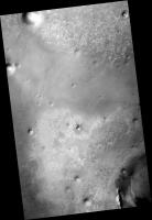
Meanwhile I found that I don't have to wait for the whole download to finish because all the files needed for CTX processing have already been transferred.
So I gave it a try and it seems to work so far  Here is my first ISIS-map projected CTX image, showing Oppys travel area between Victoria and Endeavour, re-projected with the same mapping parameters than the corresponding HiRISE-observation PSP_010341_1775.
(I possibly messed up the stretching of pixel brightness values somwhere during the processing chain, but the map projection itself seems ok so far) Sequence of ISIS programs used is: >mroctx2isis : transforms PDS IMG to ISIS Cube) >spiceinit : prepare SPICE kernels >maptemplate : create a map projection defnition file >ctxcal : perform radiometric calibration >ctxevenodd : destriping >cam2map : map projection >isis2std : transfrom ISIS cube to standard PNG format Looks like exploring this ISIS universe is going to be a lot of fun
|
|
|
|
|
|
 Nirgal Map projected CTX images ? Apr 29 2010, 02:33 PM
 elakdawalla Bernhard, I imagine Doug will reply before long wi... Apr 29 2010, 05:19 PM djellison It's fairly easy - just follow this from end t... Apr 29 2010, 08:27 PM
 Nirgal ok thank you Emily, Doug !
So it is definite... Apr 29 2010, 10:57 PM djellison QUOTE (Nirgal @ Apr 29 2010, 11:57 PM) @D... Apr 30 2010, 04:30 AM tharrison QUOTE CTX images are only released in raw PDS form... Apr 30 2010, 04:24 AM
Nirgal ok thank you Emily, Doug !
So it is definite... Apr 29 2010, 10:57 PM djellison QUOTE (Nirgal @ Apr 29 2010, 11:57 PM) @D... Apr 30 2010, 04:30 AM tharrison QUOTE CTX images are only released in raw PDS form... Apr 30 2010, 04:24 AM |

|
Lo-Fi Version | Time is now: 26th September 2024 - 07:37 PM |
|
RULES AND GUIDELINES Please read the Forum Rules and Guidelines before posting. IMAGE COPYRIGHT |
OPINIONS AND MODERATION Opinions expressed on UnmannedSpaceflight.com are those of the individual posters and do not necessarily reflect the opinions of UnmannedSpaceflight.com or The Planetary Society. The all-volunteer UnmannedSpaceflight.com moderation team is wholly independent of The Planetary Society. The Planetary Society has no influence over decisions made by the UnmannedSpaceflight.com moderators. |
SUPPORT THE FORUM Unmannedspaceflight.com is funded by the Planetary Society. Please consider supporting our work and many other projects by donating to the Society or becoming a member. |
|