New map of Phobos |

New map of Phobos |
 Mar 10 2010, 10:25 PM Mar 10 2010, 10:25 PM
Post
#1
|
|||
|
Solar System Cartographer  Group: Members Posts: 10229 Joined: 5-April 05 From: Canada Member No.: 227 |
I'm starting a thread here in Mars Express for a new map of Phobos, because most of it will be based on MEX images.
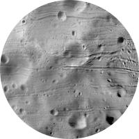
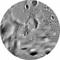
This is the first section. It's the north pole, centred on the pole, out to 50 degrees north at the edge, in azimuthal equidistant projection (i.e. the parallels of latitude are equally spaced, unlike in a stereographic projection where they would get further apart away from the pole). This image is made of Viking, Mars Express and MRO images. Below it I show what the previous best map looked like, much more compressed to save space here. That is just Viking data, compiled by Damon Simonelli et al. at Cornell in the 1990s. The actual mapping is done at twice this scale. Phil
-------------------- ... because the Solar System ain't gonna map itself.
Also to be found posting similar content on https://mastodon.social/@PhilStooke Maps for download (free PDF: https://upload.wikimedia.org/wikipedia/comm...Cartography.pdf NOTE: everything created by me which I post on UMSF is considered to be in the public domain (NOT CC, public domain) |
||
 |
 
|
||
 |
|
May 20 2010, 02:19 PM
Post
#2
|
||
|
Solar System Cartographer Group: Members Posts: 10229 Joined: 5-April 05 From: Canada Member No.: 227 |
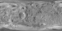
Here I have reprojected the complete Phobos mosaic from the Cornell control network to that of the recent DLR maps - you can see their maps and data including a shape model here:
http://europlanet.dlr.de/node/index.php?id=214 There are some problems in their map - bad joins between images etc. - and attempting to reproject the original mosaic to fit a problematic base image is never going to produce a perfect match. However, their recalculated pole positions and improved shape in some areas probably make positions on tghis version a bit more reliable. Overlay this over the previous one to see just how much features move between them... Anyway, if somebody was using the DLR shape for visualization, this is the version of the mosaic that should be used with it. Phil new mosaic:
I am now going to wrap all this stuff up with documentation and send it in to PDS. -------------------- ... because the Solar System ain't gonna map itself.
Also to be found posting similar content on https://mastodon.social/@PhilStooke Maps for download (free PDF: https://upload.wikimedia.org/wikipedia/comm...Cartography.pdf NOTE: everything created by me which I post on UMSF is considered to be in the public domain (NOT CC, public domain) |
|
|
|
|
|
 Phil Stooke New map of Phobos Mar 10 2010, 10:25 PM
 elakdawalla Wow, Phil, the improvement's fantastic. I can... Mar 10 2010, 10:27 PM Phil Stooke Here's the south pole. This is only a small i... Mar 15 2010, 07:04 PM Phil Stooke Taking the north and south polar sections and addi... Mar 16 2010, 04:55 PM Hungry4info Wow that looks great even in that state! Mar 16 2010, 06:42 PM Adonis ¿Is there any DTM model of Phobos available with m... Mar 18 2010, 07:36 PM Phil Stooke People are working on these things but I don't... Mar 18 2010, 09:47 PM Phil Stooke I forgot about the new atlas of Phobos and shape m... Mar 19 2010, 02:11 PM Phil Stooke Next step in the Phobos mosaic. Here's the or... Mar 19 2010, 08:56 PM Phil Stooke Latest version of the Phobos map:
Phil Mar 31 2010, 03:06 PM Phil Stooke I've finished the central panel of the big new... Apr 7 2010, 09:02 PM Ian R It looks like a real labour of love, Phil.
And b... Apr 8 2010, 10:14 AM Hungry4info Interesting flipping back and forth between the im... Apr 8 2010, 11:12 AM Phil Stooke Flip some more! Here's the next section o... Apr 16 2010, 08:17 PM Hungry4info That really is pretty cool. Do you know yet if you... Apr 16 2010, 10:17 PM Phil Stooke MRO was used in the last section, but it only just... Apr 16 2010, 11:45 PM pjam Great stuff, Phil!
Hmmm. Not sure about er... Apr 17 2010, 03:18 AM Phil Stooke I've finished the eastern end of the global ma... Apr 23 2010, 03:22 PM CAP-Team This new map already looks great in Celestia! Apr 23 2010, 07:04 PM Phil Stooke Nice to know! But wait 'til you see the n... Apr 23 2010, 07:31 PM Phil Stooke First tile of the new section. I do each section ... Apr 26 2010, 09:24 PM Phil Stooke Next tile added...
Phil
Apr 27 2010, 06:03 PM
elakdawalla Wow, Phil, the improvement's fantastic. I can... Mar 10 2010, 10:27 PM Phil Stooke Here's the south pole. This is only a small i... Mar 15 2010, 07:04 PM Phil Stooke Taking the north and south polar sections and addi... Mar 16 2010, 04:55 PM Hungry4info Wow that looks great even in that state! Mar 16 2010, 06:42 PM Adonis ¿Is there any DTM model of Phobos available with m... Mar 18 2010, 07:36 PM Phil Stooke People are working on these things but I don't... Mar 18 2010, 09:47 PM Phil Stooke I forgot about the new atlas of Phobos and shape m... Mar 19 2010, 02:11 PM Phil Stooke Next step in the Phobos mosaic. Here's the or... Mar 19 2010, 08:56 PM Phil Stooke Latest version of the Phobos map:
Phil Mar 31 2010, 03:06 PM Phil Stooke I've finished the central panel of the big new... Apr 7 2010, 09:02 PM Ian R It looks like a real labour of love, Phil.
And b... Apr 8 2010, 10:14 AM Hungry4info Interesting flipping back and forth between the im... Apr 8 2010, 11:12 AM Phil Stooke Flip some more! Here's the next section o... Apr 16 2010, 08:17 PM Hungry4info That really is pretty cool. Do you know yet if you... Apr 16 2010, 10:17 PM Phil Stooke MRO was used in the last section, but it only just... Apr 16 2010, 11:45 PM pjam Great stuff, Phil!
Hmmm. Not sure about er... Apr 17 2010, 03:18 AM Phil Stooke I've finished the eastern end of the global ma... Apr 23 2010, 03:22 PM CAP-Team This new map already looks great in Celestia! Apr 23 2010, 07:04 PM Phil Stooke Nice to know! But wait 'til you see the n... Apr 23 2010, 07:31 PM Phil Stooke First tile of the new section. I do each section ... Apr 26 2010, 09:24 PM Phil Stooke Next tile added...
Phil
Apr 27 2010, 06:03 PM
 chuckclark My, this'll teach me to run off to D.C. and mi... Apr 27 2010, 06:35 PM Hungry4info Interesting cross-thatch pattern at the lower-left... Apr 27 2010, 09:23 PM Phil Stooke Yes, and it will probably be replaced with better ... Apr 27 2010, 09:29 PM Phil Stooke Several additions now. All that remains is a long... Apr 30 2010, 04:40 PM Phil Stooke And the new map is finished:
Actually, not quit... May 7 2010, 03:44 PM jasedm A truly impressive labour of love Phil.
The Stickn... May 7 2010, 04:26 PM Hungry4info That is nothing short of amazing. It looks great ... May 8 2010, 01:29 AM nprev Beautifully rendered, Phil! May 8 2010, 02:01 AM JohnVV looking forward phil
it looks very nice May 8 2010, 06:31 AM chuckclark Here is Phil's new mosaic in a cut 'n... May 10 2010, 01:41 AM chuckclark And, for those of you who insist on the most accur... Jun 14 2010, 11:18 PM scalbers Here is a version of Phil's map with features ... Feb 23 2012, 12:01 AM machi Good work!
It looks, that you used vector font... Feb 23 2012, 11:18 AM Phil Stooke Very nice! (except something seems to have ha... Feb 23 2012, 02:30 PM scalbers Thanks for the comments and feedback. Earlier I wa... Feb 25 2012, 04:05 PM
chuckclark My, this'll teach me to run off to D.C. and mi... Apr 27 2010, 06:35 PM Hungry4info Interesting cross-thatch pattern at the lower-left... Apr 27 2010, 09:23 PM Phil Stooke Yes, and it will probably be replaced with better ... Apr 27 2010, 09:29 PM Phil Stooke Several additions now. All that remains is a long... Apr 30 2010, 04:40 PM Phil Stooke And the new map is finished:
Actually, not quit... May 7 2010, 03:44 PM jasedm A truly impressive labour of love Phil.
The Stickn... May 7 2010, 04:26 PM Hungry4info That is nothing short of amazing. It looks great ... May 8 2010, 01:29 AM nprev Beautifully rendered, Phil! May 8 2010, 02:01 AM JohnVV looking forward phil
it looks very nice May 8 2010, 06:31 AM chuckclark Here is Phil's new mosaic in a cut 'n... May 10 2010, 01:41 AM chuckclark And, for those of you who insist on the most accur... Jun 14 2010, 11:18 PM scalbers Here is a version of Phil's map with features ... Feb 23 2012, 12:01 AM machi Good work!
It looks, that you used vector font... Feb 23 2012, 11:18 AM Phil Stooke Very nice! (except something seems to have ha... Feb 23 2012, 02:30 PM scalbers Thanks for the comments and feedback. Earlier I wa... Feb 25 2012, 04:05 PM |

|
Lo-Fi Version | Time is now: 26th September 2024 - 07:58 PM |
|
RULES AND GUIDELINES Please read the Forum Rules and Guidelines before posting. IMAGE COPYRIGHT |
OPINIONS AND MODERATION Opinions expressed on UnmannedSpaceflight.com are those of the individual posters and do not necessarily reflect the opinions of UnmannedSpaceflight.com or The Planetary Society. The all-volunteer UnmannedSpaceflight.com moderation team is wholly independent of The Planetary Society. The Planetary Society has no influence over decisions made by the UnmannedSpaceflight.com moderators. |
SUPPORT THE FORUM Unmannedspaceflight.com is funded by the Planetary Society. Please consider supporting our work and many other projects by donating to the Society or becoming a member. |
|