Opportunity Route Map |

Opportunity Route Map |
 Feb 11 2005, 08:11 AM Feb 11 2005, 08:11 AM
Post
#2701
|
||
 The Insider  Group: Members Posts: 669 Joined: 3-May 04 Member No.: 73 |
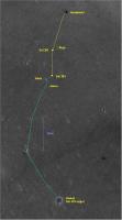
Here is an updated map of the road to Vostok.
Attached thumbnail(s)
|
|
 |
 
|
|
 |
|
Jun 23 2010, 09:44 AM
Post
#2702
|
||
|
Senior Member Group: Moderator Posts: 4279 Joined: 19-April 05 From: .br at .es Member No.: 253 |
Now, moving on to the new map, this picture will cover the whole "east drive" until reaching Santa Maria (mini-Endurance). I thought it would be better to have the whole background until that waypoint right now instead of adding those 1km squares when needed, because it is important to have the (intermediate) destination on sight. It was my initial intention to cover the whole route up to Endeavour but, again, too much to this laptop; that last section will have to be done on a third picture in the future.
Edit: updated the grid's transparency. This post has been edited by Tesheiner: Jun 24 2010, 08:24 AM |
|
|
|
|
|
 Pando Opportunity Route Map Feb 11 2005, 08:11 AM
 Tesheiner Yet another update; now after sol 2183.
About 400m... Mar 16 2010, 12:44 PM Tesheiner Sol 2184.
Mar 17 2010, 02:59 PM Tesheiner Sol 2186.
Mar 19 2010, 07:11 PM Tesheiner Sol 2188. More or less 250m to the craters.
Mar 21 2010, 03:00 PM Tesheiner Map update for sol 2190.
Mar 23 2010, 02:44 PM Tesheiner Quick update after sol 2191. The 20km mark have be... Mar 24 2010, 03:52 PM Tesheiner Sol 2193. Almost there!
Mar 26 2010, 09:08 PM climber 35-40m/sol for the last 10 sols. Mar 26 2010, 09:14 PM Tesheiner Here's the map update for sol 2194.
Mar 27 2010, 09:36 PM Tesheiner Sol 2197. Now with the official name "San Ant... Mar 30 2010, 09:55 PM climber We are ~150m from crossing the 12 kms in strait li... Mar 31 2010, 10:52 AM jamescanvin Tosol is 2200 for Oppy and no drive is planned, so... Apr 2 2010, 10:55 AM vikingmars James : thanks for you map !
The view towards ... Apr 2 2010, 03:17 PM
Tesheiner Yet another update; now after sol 2183.
About 400m... Mar 16 2010, 12:44 PM Tesheiner Sol 2184.
Mar 17 2010, 02:59 PM Tesheiner Sol 2186.
Mar 19 2010, 07:11 PM Tesheiner Sol 2188. More or less 250m to the craters.
Mar 21 2010, 03:00 PM Tesheiner Map update for sol 2190.
Mar 23 2010, 02:44 PM Tesheiner Quick update after sol 2191. The 20km mark have be... Mar 24 2010, 03:52 PM Tesheiner Sol 2193. Almost there!
Mar 26 2010, 09:08 PM climber 35-40m/sol for the last 10 sols. Mar 26 2010, 09:14 PM Tesheiner Here's the map update for sol 2194.
Mar 27 2010, 09:36 PM Tesheiner Sol 2197. Now with the official name "San Ant... Mar 30 2010, 09:55 PM climber We are ~150m from crossing the 12 kms in strait li... Mar 31 2010, 10:52 AM jamescanvin Tosol is 2200 for Oppy and no drive is planned, so... Apr 2 2010, 10:55 AM vikingmars James : thanks for you map !
The view towards ... Apr 2 2010, 03:17 PM
 SFJCody The official JPL map has been updated:
http://mar... Apr 2 2010, 04:57 PM Tesheiner ... and I forgot to post mine.
Apr 2 2010, 05:11 PM Tesheiner Here's a preliminary update after sol 2206. Th... Apr 9 2010, 09:11 AM Tesheiner Map update after sol 2208.
Apr 11 2010, 10:18 AM dilo In the last year, the effective shift was only 3.0... Apr 11 2010, 06:35 PM Tesheiner Here's yet another update, after driving on so... Apr 16 2010, 08:56 AM Tesheiner Sol 2215.
Apr 18 2010, 08:23 AM Tesheiner Sol 2218.
Apr 21 2010, 02:17 PM Tesheiner ... and the small bump on sol 2220.
Apr 23 2010, 08:38 PM Tesheiner Sol 2226.
Apr 30 2010, 07:01 AM Tesheiner Here's the current position, updated after sol... May 1 2010, 08:07 PM leFab Hello
I'm n00b as a poster to this forum and ... May 2 2010, 11:03 PM dot.dk The path ahead came from this document: http://www... May 2 2010, 11:12 PM leFab Thanks a lot, that's exactly what I was search... May 3 2010, 10:56 PM Tesheiner Latest 30m drive, during sol 2231.
May 5 2010, 07:26 AM Tesheiner Here's Opportunity's current position. Las... May 9 2010, 11:32 AM Tesheiner Map update corresponding to sol 2240.
May 14 2010, 10:13 AM Tesheiner Update after sol 2245.
May 19 2010, 09:46 AM gregsz55 At present Opportunity is outside of high resoluti... May 22 2010, 02:07 PM ElkGroveDan Greg see this post of Emily's from a couple mo... May 22 2010, 02:12 PM Tesheiner Mmm, let's see if I'm able to add a sort o... May 22 2010, 02:29 PM Tesheiner It's time for another map update; sol 2252.
May 26 2010, 08:46 PM ngunn Thanks for the big picture. We've almost round... May 26 2010, 10:28 PM Tesheiner Here's a map crop around sol 2254's positi... May 28 2010, 03:38 PM alan Here is a section of the road east to the 'pav... Jun 1 2010, 09:55 PM Tesheiner Map update after sol 2256.
Jun 2 2010, 09:30 PM Robert S [quote name='Tesheiner' post='160457... Jun 3 2010, 11:51 PM Tesheiner Here's a route map update, up to sol 2270.
Jun 14 2010, 10:52 AM ngunn And with that one drive the distance to Endeavour ... Jun 14 2010, 04:41 PM Tesheiner Here's a map crop and the corresponding GE ver... Jun 16 2010, 08:11 AM Tesheiner A quick update corresponding to sol 2274, but stil... Jun 18 2010, 11:39 AM Robert S Hello Tesheiner, thank you for your updates!
... Jun 18 2010, 01:49 PM Tesheiner QUOTE (Robert S @ Jun 18 2010, 03:49 PM) ... Jun 18 2010, 04:59 PM MoreInput QUOTE (Robert S @ Jun 18 2010, 03:49 PM) ... Jun 18 2010, 09:12 PM ngunn Is this what you're looking for?
http://www.un... Jun 18 2010, 02:53 PM Phil Stooke "Is it possible... ?"
Robert, what you ... Jun 18 2010, 05:21 PM Tesheiner Here's another update, after sol 2276.
Have a ... Jun 20 2010, 08:16 AM Deimos And judging from the grid lines, that makes a half... Jun 21 2010, 05:29 PM Tesheiner Here's yet another "plot" to the rou... Jun 23 2010, 09:42 AM jamescanvin Wow, scrolling back along the route from Victoria ... Jun 23 2010, 10:35 AM Tesheiner QUOTE (jamescanvin @ Jun 23 2010, 12:35 P... Jun 23 2010, 07:14 PM Tesheiner Done. I've updated the picture in my previous ... Jun 24 2010, 08:27 AM Tesheiner Here's another point at the map; sol 2281.
Jun 25 2010, 06:39 AM Ipparchus Hi to everybody! I was looking at Tesheiner... Jun 26 2010, 10:23 AM Astro0 While it can be fun to speculate, the one truism r... Jun 26 2010, 12:41 PM Floyd Also, this thread is for the official map--discuss... Jun 26 2010, 11:17 PM Robert S Thank you all for your answers!!! I re... Jun 27 2010, 02:20 AM Tesheiner Update after sol 2283.
Jun 27 2010, 07:30 AM Stu Aw heck, she's changed her mind about the whol... Jun 27 2010, 07:38 AM nprev Hmm. Dune avoidance maneuver? Must've seen som... Jun 27 2010, 08:01 AM Stu You're more than welcome
Hmm, looks like a... Jun 27 2010, 08:09 AM kenny yes, the last 2 maneuvres, SE to 2281 and NE to 22... Jun 27 2010, 09:15 AM Tesheiner The East trend is reinforced by today's 70m dr... Jun 30 2010, 06:50 AM Poolio While Eduardo is otherwise occupied with life... Jul 8 2010, 05:50 PM NW71 QUOTE (Poolio @ Jul 8 2010, 06:50 PM) Ano... Jul 8 2010, 10:23 PM fredk They've found that 70m backwards keeps the RF ... Jul 8 2010, 11:04 PM Tesheiner QUOTE (Poolio @ Jul 8 2010, 07:50 PM) Whi... Jul 10 2010, 09:31 AM Stu Ah, always a relief when normal service is resumed... Jul 10 2010, 09:45 AM ngunn Great news. I was just about to suggest we organis... Jul 10 2010, 11:42 AM dilo Welcome back, Eduardo!
Based on your last map,... Jul 10 2010, 02:19 PM Hungry4info QUOTE (dilo @ Jul 10 2010, 08:19 AM) Base... Jul 11 2010, 05:55 AM dilo QUOTE (Hungry4info @ Jul 11 2010, 05:55 A... Jul 11 2010, 11:52 AM Floyd Eduardo, thank you for all you do. I'm wonder... Jul 10 2010, 05:55 PM djellison Two points.
Firstly, after six and a half years, ... Jul 11 2010, 04:25 PM dilo You're right, Doug. Jul 11 2010, 10:01 PM jamescanvin My large scale 100 sol route map updated for 2300.... Jul 14 2010, 07:39 PM Drkskywxlt Doing a very crude straight line distance measure ... Jul 14 2010, 07:59 PM Tesheiner Here's a map update, including the latest driv... Jul 17 2010, 02:00 PM Nirgal Wow: 2299,2300,2301...
now she's really flying... Jul 17 2010, 03:55 PM MaxSt It's almost like they set 3 drives=200 m goal ... Jul 17 2010, 07:38 PM BrianL The 2311 traverse map is up at JPL.
http://marsro... Jul 29 2010, 12:04 AM Tesheiner I'm finally "back to business" so le... Aug 2 2010, 01:25 PM Tesheiner Sol 2320.
Aug 4 2010, 08:34 AM Tesheiner Sol 2232.
Aug 6 2010, 09:20 AM Tesheiner Here's an updated version after reading an ent... Aug 6 2010, 08:19 PM Tesheiner An update after the weekend's drive.
Aug 8 2010, 08:38 AM Tesheiner Sol 2326.
Aug 10 2010, 02:02 PM alan I have a suggestion for the daily updates: recente... Aug 10 2010, 05:48 PM Tesheiner QUOTE (alan @ Aug 10 2010, 07:48 PM) I ha... Aug 10 2010, 09:30 PM fredk Maybe it'd be easier for anyone who wants to p... Aug 10 2010, 06:05 PM ElkGroveDan Ever since Eduardo began including the Google Mars... Aug 10 2010, 09:12 PM alan Oh well, I guess I'm the only one who thinks w... Aug 11 2010, 07:00 AM Astro0 alan, I think that after 6.5 years of Tesh's m... Aug 11 2010, 07:10 AM Tesheiner Ok, here's the update corresponding to sol 232... Aug 11 2010, 09:57 AM alan So what we have is a case of 1)looks like a route ... Aug 11 2010, 11:43 AM Phil Stooke I have no problem with having to enlarge the reduc... Aug 11 2010, 01:37 PM
SFJCody The official JPL map has been updated:
http://mar... Apr 2 2010, 04:57 PM Tesheiner ... and I forgot to post mine.
Apr 2 2010, 05:11 PM Tesheiner Here's a preliminary update after sol 2206. Th... Apr 9 2010, 09:11 AM Tesheiner Map update after sol 2208.
Apr 11 2010, 10:18 AM dilo In the last year, the effective shift was only 3.0... Apr 11 2010, 06:35 PM Tesheiner Here's yet another update, after driving on so... Apr 16 2010, 08:56 AM Tesheiner Sol 2215.
Apr 18 2010, 08:23 AM Tesheiner Sol 2218.
Apr 21 2010, 02:17 PM Tesheiner ... and the small bump on sol 2220.
Apr 23 2010, 08:38 PM Tesheiner Sol 2226.
Apr 30 2010, 07:01 AM Tesheiner Here's the current position, updated after sol... May 1 2010, 08:07 PM leFab Hello
I'm n00b as a poster to this forum and ... May 2 2010, 11:03 PM dot.dk The path ahead came from this document: http://www... May 2 2010, 11:12 PM leFab Thanks a lot, that's exactly what I was search... May 3 2010, 10:56 PM Tesheiner Latest 30m drive, during sol 2231.
May 5 2010, 07:26 AM Tesheiner Here's Opportunity's current position. Las... May 9 2010, 11:32 AM Tesheiner Map update corresponding to sol 2240.
May 14 2010, 10:13 AM Tesheiner Update after sol 2245.
May 19 2010, 09:46 AM gregsz55 At present Opportunity is outside of high resoluti... May 22 2010, 02:07 PM ElkGroveDan Greg see this post of Emily's from a couple mo... May 22 2010, 02:12 PM Tesheiner Mmm, let's see if I'm able to add a sort o... May 22 2010, 02:29 PM Tesheiner It's time for another map update; sol 2252.
May 26 2010, 08:46 PM ngunn Thanks for the big picture. We've almost round... May 26 2010, 10:28 PM Tesheiner Here's a map crop around sol 2254's positi... May 28 2010, 03:38 PM alan Here is a section of the road east to the 'pav... Jun 1 2010, 09:55 PM Tesheiner Map update after sol 2256.
Jun 2 2010, 09:30 PM Robert S [quote name='Tesheiner' post='160457... Jun 3 2010, 11:51 PM Tesheiner Here's a route map update, up to sol 2270.
Jun 14 2010, 10:52 AM ngunn And with that one drive the distance to Endeavour ... Jun 14 2010, 04:41 PM Tesheiner Here's a map crop and the corresponding GE ver... Jun 16 2010, 08:11 AM Tesheiner A quick update corresponding to sol 2274, but stil... Jun 18 2010, 11:39 AM Robert S Hello Tesheiner, thank you for your updates!
... Jun 18 2010, 01:49 PM Tesheiner QUOTE (Robert S @ Jun 18 2010, 03:49 PM) ... Jun 18 2010, 04:59 PM MoreInput QUOTE (Robert S @ Jun 18 2010, 03:49 PM) ... Jun 18 2010, 09:12 PM ngunn Is this what you're looking for?
http://www.un... Jun 18 2010, 02:53 PM Phil Stooke "Is it possible... ?"
Robert, what you ... Jun 18 2010, 05:21 PM Tesheiner Here's another update, after sol 2276.
Have a ... Jun 20 2010, 08:16 AM Deimos And judging from the grid lines, that makes a half... Jun 21 2010, 05:29 PM Tesheiner Here's yet another "plot" to the rou... Jun 23 2010, 09:42 AM jamescanvin Wow, scrolling back along the route from Victoria ... Jun 23 2010, 10:35 AM Tesheiner QUOTE (jamescanvin @ Jun 23 2010, 12:35 P... Jun 23 2010, 07:14 PM Tesheiner Done. I've updated the picture in my previous ... Jun 24 2010, 08:27 AM Tesheiner Here's another point at the map; sol 2281.
Jun 25 2010, 06:39 AM Ipparchus Hi to everybody! I was looking at Tesheiner... Jun 26 2010, 10:23 AM Astro0 While it can be fun to speculate, the one truism r... Jun 26 2010, 12:41 PM Floyd Also, this thread is for the official map--discuss... Jun 26 2010, 11:17 PM Robert S Thank you all for your answers!!! I re... Jun 27 2010, 02:20 AM Tesheiner Update after sol 2283.
Jun 27 2010, 07:30 AM Stu Aw heck, she's changed her mind about the whol... Jun 27 2010, 07:38 AM nprev Hmm. Dune avoidance maneuver? Must've seen som... Jun 27 2010, 08:01 AM Stu You're more than welcome
Hmm, looks like a... Jun 27 2010, 08:09 AM kenny yes, the last 2 maneuvres, SE to 2281 and NE to 22... Jun 27 2010, 09:15 AM Tesheiner The East trend is reinforced by today's 70m dr... Jun 30 2010, 06:50 AM Poolio While Eduardo is otherwise occupied with life... Jul 8 2010, 05:50 PM NW71 QUOTE (Poolio @ Jul 8 2010, 06:50 PM) Ano... Jul 8 2010, 10:23 PM fredk They've found that 70m backwards keeps the RF ... Jul 8 2010, 11:04 PM Tesheiner QUOTE (Poolio @ Jul 8 2010, 07:50 PM) Whi... Jul 10 2010, 09:31 AM Stu Ah, always a relief when normal service is resumed... Jul 10 2010, 09:45 AM ngunn Great news. I was just about to suggest we organis... Jul 10 2010, 11:42 AM dilo Welcome back, Eduardo!
Based on your last map,... Jul 10 2010, 02:19 PM Hungry4info QUOTE (dilo @ Jul 10 2010, 08:19 AM) Base... Jul 11 2010, 05:55 AM dilo QUOTE (Hungry4info @ Jul 11 2010, 05:55 A... Jul 11 2010, 11:52 AM Floyd Eduardo, thank you for all you do. I'm wonder... Jul 10 2010, 05:55 PM djellison Two points.
Firstly, after six and a half years, ... Jul 11 2010, 04:25 PM dilo You're right, Doug. Jul 11 2010, 10:01 PM jamescanvin My large scale 100 sol route map updated for 2300.... Jul 14 2010, 07:39 PM Drkskywxlt Doing a very crude straight line distance measure ... Jul 14 2010, 07:59 PM Tesheiner Here's a map update, including the latest driv... Jul 17 2010, 02:00 PM Nirgal Wow: 2299,2300,2301...
now she's really flying... Jul 17 2010, 03:55 PM MaxSt It's almost like they set 3 drives=200 m goal ... Jul 17 2010, 07:38 PM BrianL The 2311 traverse map is up at JPL.
http://marsro... Jul 29 2010, 12:04 AM Tesheiner I'm finally "back to business" so le... Aug 2 2010, 01:25 PM Tesheiner Sol 2320.
Aug 4 2010, 08:34 AM Tesheiner Sol 2232.
Aug 6 2010, 09:20 AM Tesheiner Here's an updated version after reading an ent... Aug 6 2010, 08:19 PM Tesheiner An update after the weekend's drive.
Aug 8 2010, 08:38 AM Tesheiner Sol 2326.
Aug 10 2010, 02:02 PM alan I have a suggestion for the daily updates: recente... Aug 10 2010, 05:48 PM Tesheiner QUOTE (alan @ Aug 10 2010, 07:48 PM) I ha... Aug 10 2010, 09:30 PM fredk Maybe it'd be easier for anyone who wants to p... Aug 10 2010, 06:05 PM ElkGroveDan Ever since Eduardo began including the Google Mars... Aug 10 2010, 09:12 PM alan Oh well, I guess I'm the only one who thinks w... Aug 11 2010, 07:00 AM Astro0 alan, I think that after 6.5 years of Tesh's m... Aug 11 2010, 07:10 AM Tesheiner Ok, here's the update corresponding to sol 232... Aug 11 2010, 09:57 AM alan So what we have is a case of 1)looks like a route ... Aug 11 2010, 11:43 AM Phil Stooke I have no problem with having to enlarge the reduc... Aug 11 2010, 01:37 PM |

|
Lo-Fi Version | Time is now: 20th June 2024 - 09:56 AM |
|
RULES AND GUIDELINES Please read the Forum Rules and Guidelines before posting. IMAGE COPYRIGHT |
OPINIONS AND MODERATION Opinions expressed on UnmannedSpaceflight.com are those of the individual posters and do not necessarily reflect the opinions of UnmannedSpaceflight.com or The Planetary Society. The all-volunteer UnmannedSpaceflight.com moderation team is wholly independent of The Planetary Society. The Planetary Society has no influence over decisions made by the UnmannedSpaceflight.com moderators. |
SUPPORT THE FORUM Unmannedspaceflight.com is funded by the Planetary Society. Please consider supporting our work and many other projects by donating to the Society or becoming a member. |
|