Geomorphology of Cape York and Solander Point, Examining Opportunity's destination at Endeavour Crater |

Geomorphology of Cape York and Solander Point, Examining Opportunity's destination at Endeavour Crater |
 Jul 6 2010, 07:52 PM Jul 6 2010, 07:52 PM
Post
#1
|
||
 The Poet Dude  Group: Moderator Posts: 5551 Joined: 15-March 04 From: Kendal, Cumbria, UK Member No.: 60 |
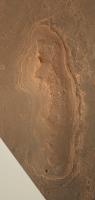
Everyone, say hello to Cape York... in colour...
Larger version on my blog: http://roadtoendeavour.wordpress.com/2010/...-york-in-colour -------------------- |
|
 |
 
|
|
 |
|
Jul 8 2010, 05:26 PM
Post
#2
|
|
 Member Group: Members Posts: 656 Joined: 20-April 05 From: League City, Texas Member No.: 285 |
Great stereo, Stu (much better than the one I improvised). The more I look at this, the more I think "beach". Consider that, if Endeavour were flooded, with the water extending beyond the current rim (so that Cape York was an island), the big open deep water would be to the east of Cape York, and consequently the major wave action would be from that direction. All along the east side of Cape York is what appears to be a longshore bar, which might be expected from that wave action. This feature is largely lacking to the west. It makes sense that, as the water declined, water which accumulated behind the bar would channelize and flow through gaps. While the Wedge seems most prominent, I also see signs of channels to the south of it (immediately below the apparent small crater in the "bar", and a smaller channel at the northern "point" of Cape York. I see signs of channels feeding into these 3 outlets which are traceable southwards beyond half the length of the Cape.
Here's a portion Wikipedia's description of beach geology: "There are several conspicuous parts to a beach, all of which relate to the processes that form and shape it. The part mostly above water (depending upon tide), and more or less actively influenced by the waves at some point in the tide, is termed the beach berm. The berm is the deposit of material comprising the active shoreline. The berm has a crest (top) and a face the latter being the slope leading down towards the water from the crest. At the very bottom of the face, there may be a trough, and further seaward one or more longshore bars: slightly raised, underwater embankments formed where the waves first start to break. The sand deposit may extend well inland from the berm crest, where there may be evidence of one or more older crests (the storm beach) resulting from very large storm waves and beyond the influence of the normal waves. At some point the influence of the waves (even storm waves) on the material comprising the beach stops, and if the particles are small enough (sand size or smaller) , winds shape the feature. Where wind is the force distributing the grains inland, the deposit behind the beach becomes a dune." |
|
|
|
 Stu Geomorphology of Cape York and Solander Point Jul 6 2010, 07:52 PM
 ElkGroveDan QUOTE (Stu @ Jul 6 2010, 12:52 PM) Everyo... Jul 6 2010, 10:26 PM algorimancer QUOTE (Stu @ Jul 6 2010, 01:52 PM) ...Cap... Jul 7 2010, 05:37 PM
 ElkGroveDan QUOTE (algorimancer @ Jul 7 2010, 10:37 A... Jul 7 2010, 08:47 PM Phil Stooke Those rings - don't think waterlines, the topo... Jul 7 2010, 06:18 PM walfy QUOTE (Phil Stooke @ Jul 7 2010, 10:18 AM... Jul 7 2010, 06:28 PM algorimancer This sounds sensible, with the caveat that slopes ... Jul 7 2010, 06:33 PM ngunn Somewhere we have already had a nice stratigrapher... Jul 7 2010, 09:27 PM Bill Harris +1 on Phil's observation: "Think instead:... Jul 7 2010, 10:04 PM Stu Some of you might find this useful... bit less blu... Jul 7 2010, 10:50 PM brellis The pic from Stu's post 570 sure makes the Wed... Jul 8 2010, 07:23 AM serpens The rim of Endeavour is really eroded and the meri... Jul 8 2010, 03:46 AM Bill Harris Any possibilities are, well, possible. We'l... Jul 8 2010, 07:26 AM Drkskywxlt What are the approximate dimensions of Cape York? ... Jul 8 2010, 02:35 PM Stu VERY roughly, 660m long by 160m wide. Height? Imag... Jul 8 2010, 03:15 PM algorimancer A waterfall .... now, that's a neat idea. I... Jul 8 2010, 03:19 PM Stu QUOTE (algorimancer @ Jul 8 2010, 04:19 P... Jul 8 2010, 04:49 PM JohnVV waterfall , i guess it is time to start to rethink... Jul 8 2010, 03:28 PM algorimancer Well, I said a "good" stereo pair would ... Jul 8 2010, 03:33 PM Phil Stooke I guess my reason for preferring a non-shoreline m... Jul 8 2010, 03:39 PM Stu QUOTE (Phil Stooke @ Jul 8 2010, 04:39 PM... Jul 8 2010, 04:51 PM ElkGroveDan QUOTE (Stu @ Jul 8 2010, 09:51 AM) I... Jul 8 2010, 05:02 PM Bill Harris Phil, my take on this is the deposition of and dif... Jul 8 2010, 04:04 PM ngunn QUOTE (algorimancer @ Jul 8 2010, 06:26 P... Jul 9 2010, 08:45 AM Stu QUOTE (algorimancer @ Jul 8 2010, 06:26 P... Jul 8 2010, 05:30 PM ngunn Back to something I mentioned before but, since at... Jul 8 2010, 06:34 PM algorimancer QUOTE (ngunn @ Jul 8 2010, 12:34 PM) ...I... Jul 8 2010, 07:57 PM Ant103 Okay…… Jul 8 2010, 10:26 PM djellison I'm wondering if you could take word-pedantry ... Jul 8 2010, 11:18 PM sariondil QUOTE I'm surprised that no-one here has serio... Jul 8 2010, 11:19 PM serpens Trying to confirm a shoreline after a few billion ... Jul 9 2010, 02:24 AM monty python Just to toss in my 2 cents worth, when I look at c... Jul 9 2010, 06:03 AM sariondil Judging from the DTM I used in post #30, the lake ... Jul 9 2010, 09:35 AM ngunn Time for me to take another look at the Tribulatio... Jul 9 2010, 11:00 AM MarkG I have my doubts about wave erosion and shores, at... Jul 13 2010, 07:01 AM vikingmars Stu, your mosaic is great !
Thanks to it, I re... Feb 9 2011, 10:59 AM centsworth_II QUOTE (vikingmars @ Feb 9 2011, 05:59 AM)... Feb 9 2011, 01:16 PM stevesliva QUOTE (centsworth_II @ Feb 9 2011, 09:16 ... Feb 9 2011, 04:08 PM vikingmars QUOTE (centsworth_II @ Feb 9 2011, 02:16 ... Feb 10 2011, 09:50 AM ngunn Just a reminder - link back to Nirgal's 3D fea... Feb 9 2011, 11:46 AM MarkG The "shore-like" features around Cape Yo... Feb 9 2011, 04:56 PM MoreInput Just an intermediate hint (from Emily): There is a... Feb 9 2011, 09:08 PM serpens Try this link
http://www.gps.caltech.edu/~grotz/P... Feb 10 2011, 04:21 AM pgrindrod I've had a look at Cape York in my HiRISE DEM ... Feb 10 2011, 04:31 PM fredk This is great - thanks Pete. Have you tested your... Feb 10 2011, 05:28 PM PDP8E Pete., your Hirise DEM profile of Cape York is ver... Feb 10 2011, 06:18 PM eoincampbell So Cape York appears to be quite a bit inside Ende... Feb 11 2011, 01:55 AM pgrindrod Let's see if we can get anything else out of m... Feb 11 2011, 02:38 PM pgrindrod And while I'm filling up the place with images... Feb 11 2011, 02:47 PM ElkGroveDan I joked previously that maybe Cape York is nothing... Feb 11 2011, 03:03 PM fredk Thanks again, Pete. Those profiles certainly look... Feb 11 2011, 03:23 PM vikingmars QUOTE (fredk @ Feb 11 2011, 04:23 PM) Tha... Feb 12 2011, 12:09 PM serpens QUOTE (fredk @ Feb 11 2011, 03:23 PM) Tha... Feb 12 2011, 11:05 PM BrianL Looking at that 3D view, Cape York seems less like... Feb 12 2011, 03:53 PM climber QUOTE (BrianL @ Feb 12 2011, 04:53 PM) Lo... Feb 12 2011, 08:43 PM fredk You might be right about that, but I think we... Feb 13 2011, 03:38 AM Stu Ok... trying to get my head around this... We... Feb 13 2011, 07:31 AM serpens The perennial problem with visual representations ... Feb 13 2011, 08:15 AM Stu Gotcha, thanks.
Still... hill... ledge... island... Feb 13 2011, 08:18 AM CosmicRocker That's right, Stu. The profiles in pgridrods... Feb 13 2011, 08:37 AM Stu Thanks cosmic; I had read those posts... I was jus... Feb 13 2011, 08:43 AM serpens Stu. I see what you mean. The NW rim has been ero... Feb 13 2011, 09:55 AM ngunn Stu - or anyone handy with Google Mars - can you i... Feb 13 2011, 12:46 PM Stu Wider angle view...
Remember, tho, that everyth... Feb 13 2011, 01:40 PM ngunn QUOTE (Stu @ Feb 13 2011, 01:40 PM) Wider... Feb 13 2011, 06:09 PM CosmicRocker You have to be very careful when looking at elevat... Feb 13 2011, 05:20 PM Stu Oh I agree, absolutely. I don't rely on GM, go... Feb 13 2011, 05:24 PM elakdawalla I'd like to remind those of you engaging in th... Feb 14 2011, 03:28 AM Stu Oh, heck, we were just having a bit of fun specula... Feb 14 2011, 06:40 AM ElkGroveDan QUOTE (Stu @ Feb 13 2011, 10:40 PM) But o... Feb 14 2011, 06:49 AM pgrindrod Just to add to the ways of getting across the geom... Feb 15 2011, 05:30 PM CosmicRocker Nice, Pete; but I think you got the red and cyan l... Feb 16 2011, 08:00 AM mhoward Excellent movie and anaglyph. But yes, the red and... Feb 16 2011, 05:30 PM marswiggle While we have seen very nice DEMs and a couple of ... Feb 16 2011, 07:59 PM Stu Now that we're officially "on our way... Mar 31 2011, 03:48 PM bgarlick While we are waiting to see Cape York, some Geolog... Jul 19 2011, 06:19 PM Julius I am no planetary geologist and therfore may not b... Jul 19 2011, 06:32 PM centsworth_II QUOTE (Julius @ Jul 19 2011, 01:32 PM) ..... Jul 19 2011, 06:56 PM bgarlick QUOTE (centsworth_II @ Jul 19 2011, 10:56... Jul 19 2011, 07:14 PM marsophile There has been no mention of a hematite signature ... Jul 19 2011, 08:22 PM Phil Stooke The CRISM composition data certainly don't see... Jul 19 2011, 09:15 PM bgarlick QUOTE (Phil Stooke @ Jul 19 2011, 01:15 P... Jul 19 2011, 11:00 PM marsophile QUOTE (bgarlick @ Jul 19 2011, 04:00 PM) ... Jul 19 2011, 11:20 PM fredk QUOTE (Phil Stooke @ Jul 19 2011, 09:15 P... Jul 19 2011, 11:58 PM centsworth_II QUOTE (Phil Stooke @ Jul 19 2011, 05:15 P... Jul 20 2011, 03:32 PM serpens The topography inside Endeavour would seem to indi... Jul 20 2011, 12:34 AM Gladstoner . Jul 20 2011, 01:23 AM centsworth_II QUOTE (Gladstoner @ Jul 19 2011, 09:23 PM... Jul 20 2011, 03:59 PM Gladstoner . Jul 20 2011, 06:44 PM Gladstoner . Jul 21 2011, 12:12 AM Juramike I think I like your very first diagram the best (p... Jul 21 2011, 01:05 AM Gladstoner . Jul 21 2011, 01:37 AM Gladstoner . Aug 9 2011, 12:48 AM centsworth_II QUOTE (Gladstoner @ Aug 8 2011, 07:48 PM)... Aug 9 2011, 01:16 AM Juramike I'm not sure, but I think the uplifted rims of... Aug 9 2011, 01:05 AM Gladstoner . Aug 9 2011, 01:16 AM CosmicRocker centsworth_II: There was an ejecta layer at Victo... Aug 9 2011, 04:35 AM centsworth_II QUOTE (CosmicRocker @ Aug 8 2011, 11:35 P... Aug 9 2011, 06:33 AM Juramike So you are thinking that the Endeavour ejecta is b... Aug 9 2011, 10:33 AM
ElkGroveDan QUOTE (algorimancer @ Jul 7 2010, 10:37 A... Jul 7 2010, 08:47 PM Phil Stooke Those rings - don't think waterlines, the topo... Jul 7 2010, 06:18 PM walfy QUOTE (Phil Stooke @ Jul 7 2010, 10:18 AM... Jul 7 2010, 06:28 PM algorimancer This sounds sensible, with the caveat that slopes ... Jul 7 2010, 06:33 PM ngunn Somewhere we have already had a nice stratigrapher... Jul 7 2010, 09:27 PM Bill Harris +1 on Phil's observation: "Think instead:... Jul 7 2010, 10:04 PM Stu Some of you might find this useful... bit less blu... Jul 7 2010, 10:50 PM brellis The pic from Stu's post 570 sure makes the Wed... Jul 8 2010, 07:23 AM serpens The rim of Endeavour is really eroded and the meri... Jul 8 2010, 03:46 AM Bill Harris Any possibilities are, well, possible. We'l... Jul 8 2010, 07:26 AM Drkskywxlt What are the approximate dimensions of Cape York? ... Jul 8 2010, 02:35 PM Stu VERY roughly, 660m long by 160m wide. Height? Imag... Jul 8 2010, 03:15 PM algorimancer A waterfall .... now, that's a neat idea. I... Jul 8 2010, 03:19 PM Stu QUOTE (algorimancer @ Jul 8 2010, 04:19 P... Jul 8 2010, 04:49 PM JohnVV waterfall , i guess it is time to start to rethink... Jul 8 2010, 03:28 PM algorimancer Well, I said a "good" stereo pair would ... Jul 8 2010, 03:33 PM Phil Stooke I guess my reason for preferring a non-shoreline m... Jul 8 2010, 03:39 PM Stu QUOTE (Phil Stooke @ Jul 8 2010, 04:39 PM... Jul 8 2010, 04:51 PM ElkGroveDan QUOTE (Stu @ Jul 8 2010, 09:51 AM) I... Jul 8 2010, 05:02 PM Bill Harris Phil, my take on this is the deposition of and dif... Jul 8 2010, 04:04 PM ngunn QUOTE (algorimancer @ Jul 8 2010, 06:26 P... Jul 9 2010, 08:45 AM Stu QUOTE (algorimancer @ Jul 8 2010, 06:26 P... Jul 8 2010, 05:30 PM ngunn Back to something I mentioned before but, since at... Jul 8 2010, 06:34 PM algorimancer QUOTE (ngunn @ Jul 8 2010, 12:34 PM) ...I... Jul 8 2010, 07:57 PM Ant103 Okay…… Jul 8 2010, 10:26 PM djellison I'm wondering if you could take word-pedantry ... Jul 8 2010, 11:18 PM sariondil QUOTE I'm surprised that no-one here has serio... Jul 8 2010, 11:19 PM serpens Trying to confirm a shoreline after a few billion ... Jul 9 2010, 02:24 AM monty python Just to toss in my 2 cents worth, when I look at c... Jul 9 2010, 06:03 AM sariondil Judging from the DTM I used in post #30, the lake ... Jul 9 2010, 09:35 AM ngunn Time for me to take another look at the Tribulatio... Jul 9 2010, 11:00 AM MarkG I have my doubts about wave erosion and shores, at... Jul 13 2010, 07:01 AM vikingmars Stu, your mosaic is great !
Thanks to it, I re... Feb 9 2011, 10:59 AM centsworth_II QUOTE (vikingmars @ Feb 9 2011, 05:59 AM)... Feb 9 2011, 01:16 PM stevesliva QUOTE (centsworth_II @ Feb 9 2011, 09:16 ... Feb 9 2011, 04:08 PM vikingmars QUOTE (centsworth_II @ Feb 9 2011, 02:16 ... Feb 10 2011, 09:50 AM ngunn Just a reminder - link back to Nirgal's 3D fea... Feb 9 2011, 11:46 AM MarkG The "shore-like" features around Cape Yo... Feb 9 2011, 04:56 PM MoreInput Just an intermediate hint (from Emily): There is a... Feb 9 2011, 09:08 PM serpens Try this link
http://www.gps.caltech.edu/~grotz/P... Feb 10 2011, 04:21 AM pgrindrod I've had a look at Cape York in my HiRISE DEM ... Feb 10 2011, 04:31 PM fredk This is great - thanks Pete. Have you tested your... Feb 10 2011, 05:28 PM PDP8E Pete., your Hirise DEM profile of Cape York is ver... Feb 10 2011, 06:18 PM eoincampbell So Cape York appears to be quite a bit inside Ende... Feb 11 2011, 01:55 AM pgrindrod Let's see if we can get anything else out of m... Feb 11 2011, 02:38 PM pgrindrod And while I'm filling up the place with images... Feb 11 2011, 02:47 PM ElkGroveDan I joked previously that maybe Cape York is nothing... Feb 11 2011, 03:03 PM fredk Thanks again, Pete. Those profiles certainly look... Feb 11 2011, 03:23 PM vikingmars QUOTE (fredk @ Feb 11 2011, 04:23 PM) Tha... Feb 12 2011, 12:09 PM serpens QUOTE (fredk @ Feb 11 2011, 03:23 PM) Tha... Feb 12 2011, 11:05 PM BrianL Looking at that 3D view, Cape York seems less like... Feb 12 2011, 03:53 PM climber QUOTE (BrianL @ Feb 12 2011, 04:53 PM) Lo... Feb 12 2011, 08:43 PM fredk You might be right about that, but I think we... Feb 13 2011, 03:38 AM Stu Ok... trying to get my head around this... We... Feb 13 2011, 07:31 AM serpens The perennial problem with visual representations ... Feb 13 2011, 08:15 AM Stu Gotcha, thanks.
Still... hill... ledge... island... Feb 13 2011, 08:18 AM CosmicRocker That's right, Stu. The profiles in pgridrods... Feb 13 2011, 08:37 AM Stu Thanks cosmic; I had read those posts... I was jus... Feb 13 2011, 08:43 AM serpens Stu. I see what you mean. The NW rim has been ero... Feb 13 2011, 09:55 AM ngunn Stu - or anyone handy with Google Mars - can you i... Feb 13 2011, 12:46 PM Stu Wider angle view...
Remember, tho, that everyth... Feb 13 2011, 01:40 PM ngunn QUOTE (Stu @ Feb 13 2011, 01:40 PM) Wider... Feb 13 2011, 06:09 PM CosmicRocker You have to be very careful when looking at elevat... Feb 13 2011, 05:20 PM Stu Oh I agree, absolutely. I don't rely on GM, go... Feb 13 2011, 05:24 PM elakdawalla I'd like to remind those of you engaging in th... Feb 14 2011, 03:28 AM Stu Oh, heck, we were just having a bit of fun specula... Feb 14 2011, 06:40 AM ElkGroveDan QUOTE (Stu @ Feb 13 2011, 10:40 PM) But o... Feb 14 2011, 06:49 AM pgrindrod Just to add to the ways of getting across the geom... Feb 15 2011, 05:30 PM CosmicRocker Nice, Pete; but I think you got the red and cyan l... Feb 16 2011, 08:00 AM mhoward Excellent movie and anaglyph. But yes, the red and... Feb 16 2011, 05:30 PM marswiggle While we have seen very nice DEMs and a couple of ... Feb 16 2011, 07:59 PM Stu Now that we're officially "on our way... Mar 31 2011, 03:48 PM bgarlick While we are waiting to see Cape York, some Geolog... Jul 19 2011, 06:19 PM Julius I am no planetary geologist and therfore may not b... Jul 19 2011, 06:32 PM centsworth_II QUOTE (Julius @ Jul 19 2011, 01:32 PM) ..... Jul 19 2011, 06:56 PM bgarlick QUOTE (centsworth_II @ Jul 19 2011, 10:56... Jul 19 2011, 07:14 PM marsophile There has been no mention of a hematite signature ... Jul 19 2011, 08:22 PM Phil Stooke The CRISM composition data certainly don't see... Jul 19 2011, 09:15 PM bgarlick QUOTE (Phil Stooke @ Jul 19 2011, 01:15 P... Jul 19 2011, 11:00 PM marsophile QUOTE (bgarlick @ Jul 19 2011, 04:00 PM) ... Jul 19 2011, 11:20 PM fredk QUOTE (Phil Stooke @ Jul 19 2011, 09:15 P... Jul 19 2011, 11:58 PM centsworth_II QUOTE (Phil Stooke @ Jul 19 2011, 05:15 P... Jul 20 2011, 03:32 PM serpens The topography inside Endeavour would seem to indi... Jul 20 2011, 12:34 AM Gladstoner . Jul 20 2011, 01:23 AM centsworth_II QUOTE (Gladstoner @ Jul 19 2011, 09:23 PM... Jul 20 2011, 03:59 PM Gladstoner . Jul 20 2011, 06:44 PM Gladstoner . Jul 21 2011, 12:12 AM Juramike I think I like your very first diagram the best (p... Jul 21 2011, 01:05 AM Gladstoner . Jul 21 2011, 01:37 AM Gladstoner . Aug 9 2011, 12:48 AM centsworth_II QUOTE (Gladstoner @ Aug 8 2011, 07:48 PM)... Aug 9 2011, 01:16 AM Juramike I'm not sure, but I think the uplifted rims of... Aug 9 2011, 01:05 AM Gladstoner . Aug 9 2011, 01:16 AM CosmicRocker centsworth_II: There was an ejecta layer at Victo... Aug 9 2011, 04:35 AM centsworth_II QUOTE (CosmicRocker @ Aug 8 2011, 11:35 P... Aug 9 2011, 06:33 AM Juramike So you are thinking that the Endeavour ejecta is b... Aug 9 2011, 10:33 AM |

|
Lo-Fi Version | Time is now: 26th September 2024 - 03:59 PM |
|
RULES AND GUIDELINES Please read the Forum Rules and Guidelines before posting. IMAGE COPYRIGHT |
OPINIONS AND MODERATION Opinions expressed on UnmannedSpaceflight.com are those of the individual posters and do not necessarily reflect the opinions of UnmannedSpaceflight.com or The Planetary Society. The all-volunteer UnmannedSpaceflight.com moderation team is wholly independent of The Planetary Society. The Planetary Society has no influence over decisions made by the UnmannedSpaceflight.com moderators. |
SUPPORT THE FORUM Unmannedspaceflight.com is funded by the Planetary Society. Please consider supporting our work and many other projects by donating to the Society or becoming a member. |
|