The power of HiRISE |

The power of HiRISE |
 Oct 9 2008, 08:04 PM Oct 9 2008, 08:04 PM
Post
#101
|
||
 The Poet Dude  Group: Moderator Posts: 5551 Joined: 15-March 04 From: Kendal, Cumbria, UK Member No.: 60 |
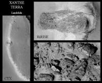
Busy preparing a new Outreach talk here, and have been trying to find some images to illustrate the "power" of HiRISE for a non-technical audience. Playing about with - sorry, carefully looking at the images on - the addictive Mars Global Data site I found a cute landslide on Xanthe Terra that does the trick nicely. Using the IAS Viewer you can zoom in on the boulders carried down the slope by the landslide and even see cracks and splits in them... unbelievable...!

Anyone else got any fave examples? -------------------- |
|
 |
 
|
|
 |
|
Jul 29 2010, 02:21 PM
Post
#102
|
||
|
Solar System Cartographer Group: Members Posts: 10229 Joined: 5-April 05 From: Canada Member No.: 227 |
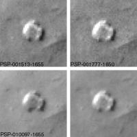
Somewhere recently we were discussing the possibility of using super-resolution with scanning cameras, specifically HiRISE. I did an experiment using pictures of the old Spirit lander. I tried finding images of other places at Meridiani - Beagle crater, Eagle crater... but the difficulty was finding multiple high quality images of the same location with comparable lighting and atmospheric conditions. Despite what you might think there are not many places where the coverage is OK for this. For instance, Opportunity can be illuminated from either the north or the south at different seasons, and that wrecks any chance of combining images effectively. If you compare the three raw images you can see how each one samples the target slightly differently.
Anyway, here's a composite of five images of the Spirit lander, compared with the three best images of the set (the other two are less satisfactory in image quality and lighting). I'm using the versions which are not map projected, but I have then had to do some work myself to register them reasonably well. The composite was made by enlarging to 4x the original scale and registering, but without the addition of sharpening any layers. It shows some promise, I think, but the process would benefit from specially targeted images taken at the same season. Not very likely in my opinion! Phil
-------------------- ... because the Solar System ain't gonna map itself.
Also to be found posting similar content on https://mastodon.social/@PhilStooke Maps for download (free PDF: https://upload.wikimedia.org/wikipedia/comm...Cartography.pdf NOTE: everything created by me which I post on UMSF is considered to be in the public domain (NOT CC, public domain) |
|
|
|
|
|
 Stu The power of HiRISE Oct 9 2008, 08:04 PM
 imipak QUOTE (stu)It's not a "find"; the im... Oct 19 2009, 11:08 PM Stu Some colourised crops of the amazing layers visibl... Nov 19 2009, 08:41 AM brellis thx for those crops Stu. Looks like some dried up... Nov 19 2009, 01:18 PM PDP8E Stu,
Your work rocks!
(next time I am in Engl... Nov 19 2009, 02:57 PM climber Also some view of Arabia Terra plus more on this ... Nov 19 2009, 07:18 PM Stu Magnificent dunes, with extra added gully goodness... Nov 29 2009, 08:59 AM pgrindrod In the spirit of HiRISE releasing some DTMs, I tho... Dec 12 2009, 09:52 PM
imipak QUOTE (stu)It's not a "find"; the im... Oct 19 2009, 11:08 PM Stu Some colourised crops of the amazing layers visibl... Nov 19 2009, 08:41 AM brellis thx for those crops Stu. Looks like some dried up... Nov 19 2009, 01:18 PM PDP8E Stu,
Your work rocks!
(next time I am in Engl... Nov 19 2009, 02:57 PM climber Also some view of Arabia Terra plus more on this ... Nov 19 2009, 07:18 PM Stu Magnificent dunes, with extra added gully goodness... Nov 29 2009, 08:59 AM pgrindrod In the spirit of HiRISE releasing some DTMs, I tho... Dec 12 2009, 09:52 PM Nirgal QUOTE (pgrindrod @ Dec 12 2009, 10:52 PM)... Dec 13 2009, 09:34 PM
 djellison QUOTE (pgrindrod @ Dec 12 2009, 09:52 PM)... Jan 9 2010, 03:48 AM machi Wow, magnificent view (especially second image)... Dec 12 2009, 11:24 PM elakdawalla That's OK. As you know, there are plenty of w... Dec 12 2009, 11:58 PM machi Yes!
So much to do and so little time.
Than... Dec 13 2009, 01:27 AM OWW Interesting. Part of this layer seems to have coll... Dec 25 2009, 11:31 PM stevesliva Almost looks like an impact into really friable sa... Dec 26 2009, 12:12 AM charborob Here's an interesting image of some Mars spire... Dec 28 2009, 01:38 AM charborob Just from an aesthetic point of view, I find this ... Dec 28 2009, 04:21 AM Stu Colourised view of gullies...
Jan 9 2010, 12:44 AM Astro0 ADMIN OOPS!
Accidentally lost this message whe... Jan 16 2010, 06:32 AM Stu Wow... a natural "cairn" on Mars...
(cr... Jan 16 2010, 08:58 PM sgendreau What you mean "natural?" It's OBVIO... Jan 16 2010, 10:50 PM climber More and more ammazing beauty
Jan 18 2010, 10:49 PM nprev ...okay, THAT is flat-out cool as hell!!... Jan 18 2010, 10:57 PM climber QUOTE (nprev @ Jan 18 2010, 11:57 PM) How... Jan 19 2010, 11:51 AM helvick Aren't they the dune peaks? If they aren't... Jan 18 2010, 11:58 PM nprev Yeah, you must be right. It's hard (for me, an... Jan 19 2010, 12:05 AM Floyd My guess--Orange stripes are dune peaks, rocks at ... Jan 19 2010, 12:11 AM Ames No the dunes are very dark and the bedrock is ligh... Jan 19 2010, 09:39 AM Stu It actually helps - as is often the case with HiRI... Jan 19 2010, 10:02 AM tharrison QUOTE (Stu @ Jan 19 2010, 02:02 AM) The b... Jan 19 2010, 01:36 PM Nirgal QUOTE (Stu @ Jan 19 2010, 11:02 AM) (very... Jan 19 2010, 06:06 PM OWW In the CTX image P21_009058_1349_XI_45S255W
I saw ... Jan 27 2010, 01:02 AM Nirgal QUOTE (OWW @ Jan 27 2010, 02:02 AM) In th... Jan 28 2010, 12:35 AM OWW Nice work Nirgal. Looks very flat. Judging by the ... Feb 1 2010, 07:56 PM nprev Freaky-looking thing. The whole area looks like ei... Jan 27 2010, 01:15 AM Juramike I'd go with a deposit leftover from some sorta... Jan 27 2010, 01:18 AM elakdawalla Nice catch; that is truly weird. Based on other n... Jan 27 2010, 03:01 AM OWW QUOTE (elakdawalla @ Jan 27 2010, 04:01 A... Jan 27 2010, 10:57 AM sariondil I don´t think this is part of a crater wall. Note ... Jan 27 2010, 09:53 AM OWW This is very strange. I can see those links again ... Feb 2 2010, 09:58 PM Tman The "Crater garden" west of Victoria fro... Mar 24 2010, 09:30 PM SFJCody Fresh looking crater (crater-pair?) about 9.5km so... Mar 24 2010, 09:43 PM Stu Oppy's Lewis and Clark trek across the great m... Mar 24 2010, 10:42 PM Explorer1 QUOTE (Stu @ Mar 24 2010, 02:42 PM) Oppy... Mar 25 2010, 01:27 AM Poolio Beginning of the westward route. Those are Nereus... Mar 25 2010, 02:19 AM Explorer1 Thanks.
That was so long ago, it's hard to be... Mar 25 2010, 05:09 AM Stu A crop from http://hirise.lpl.arizona.edu/PSP_0024... Mar 25 2010, 10:53 PM JohnVV how about this from the same hirise image
or
Mar 26 2010, 06:20 AM Stu New astropoem, dedicated to all the people on the ... Mar 27 2010, 05:13 PM Stu Today's batch of new releases includes an imag... Apr 7 2010, 10:50 PM ElkGroveDan QUOTE (Stu @ Apr 7 2010, 02:50 PM) Today... Apr 8 2010, 03:30 AM Stu ... and a new, rather gorgeous avalanche shot...
... Apr 7 2010, 11:09 PM Tom Gwilym Quote removed - Mod
Just about to go to bed, then... Apr 8 2010, 07:27 AM nprev Those are both exceptional images, Stu, thanks... Apr 8 2010, 12:18 AM Explorer1 So this is what, the 3rd avalanche caught in the a... Apr 8 2010, 04:01 AM centsworth_II QUOTE (Explorer1 @ Apr 7 2010, 11:01 PM) ... Apr 8 2010, 06:05 AM nprev The fact that MRO doesn't have any motion dete... Apr 8 2010, 04:15 AM OWW Crater near graben in Syria Mons: http://hirise.lp... Apr 9 2010, 12:30 PM schaffman QUOTE (OWW @ Apr 9 2010, 08:30 AM) Crater... Apr 11 2010, 01:21 PM OWW square crater(?). http://hirise.lpl.arizona.edu/ES... Apr 9 2010, 01:18 PM sariondil Probably not a square crater, but an outcrop of fo... Apr 9 2010, 02:56 PM Stu "Baby" avalanche spotted on an image ( E... Apr 10 2010, 07:13 AM Explorer1 Oh wow!
http://www.universetoday.com/2010/05/... May 11 2010, 01:30 AM nprev Interesting, but I dunno if I buy it. Why isn... May 11 2010, 02:14 PM Tesheiner QUOTE (nprev @ May 11 2010, 04:14 PM) Why... May 11 2010, 02:56 PM tharrison QUOTE (nprev @ May 11 2010, 07:14 AM) Int... Jun 8 2010, 05:27 AM ElkGroveDan I agree with Eduardo. Nick you of all people shou... May 11 2010, 04:32 PM climber I'll be interested to know how steep is the pl... May 11 2010, 07:44 PM schaffman The dust avalanche is now featured at the HiRISE w... May 12 2010, 11:56 AM Stu Anyone else having trouble opening up images with ... May 16 2010, 07:01 AM JohnVV never used it till now.
it is crashing on Arch Lin... May 16 2010, 07:20 AM Stu Thanks, John. Anyone else? May 16 2010, 07:33 AM nomisn Hi Stu
Just tried opening a HIRISE photo using IA... May 16 2010, 08:15 AM Tman Yes, (here) it stops when the main window has open... May 16 2010, 08:24 AM Stu Thanks everyone who responded, appreciate it. So d... May 16 2010, 08:25 AM climber More beauties here: http://www.spaceflightnow.com/... Jul 16 2010, 02:32 PM vikingmars QUOTE (Phil Stooke @ Jul 29 2010, 04:21 P... Oct 7 2010, 12:33 PM ElkGroveDan Thanks Phil. Here was your previous post.
This ... Jul 29 2010, 02:34 PM Stu Oooh, that's pretty...
(crop from ESP_01882... Oct 6 2010, 08:24 PM elakdawalla Although I'm not totally sure I agree with the... Oct 6 2010, 08:30 PM fredk QUOTE (elakdawalla @ Oct 6 2010, 09:30 PM... Oct 10 2010, 02:38 AM Stu Hmmm. Good point about the deposition, hadn't ... Oct 6 2010, 08:36 PM ngunn 'Dry water' has just been in the news: htt... Oct 6 2010, 09:54 PM Juramike QUOTE (ngunn @ Oct 6 2010, 04:54 PM) ... Oct 10 2010, 04:44 AM nprev Yeah, that looks like a pretty unlikely substance,... Oct 10 2010, 05:10 AM lavaphile The blue color is typical of ice in HiRISE "e... Oct 19 2010, 05:40 PM sgendreau About 700m (2500 ft) and darn near vertical. Oct 21 2010, 10:41 PM monitorlizard Don't really want to start a new topic, so I... Oct 29 2010, 09:36 PM nprev Rats. Nothing serious (yet), but it always hurts t... Oct 30 2010, 12:13 AM monitorlizard I should add, for those who are interested in CRIS... Oct 30 2010, 06:33 PM Stu
Colourisation of 'rock bridge' seen on o... Nov 17 2010, 08:20 PM vikingmars Some stunning pics of the interior of giant Mars p... Dec 23 2010, 10:52 AM SteveM QUOTE (vikingmars @ Dec 23 2010, 05:52 AM... Dec 23 2010, 04:20 PM djellison QUOTE (SteveM @ Dec 23 2010, 08:20 AM) Ve... Dec 23 2010, 08:59 PM SteveM QUOTE (djellison @ Dec 23 2010, 03:59 PM)... Dec 24 2010, 08:11 PM Tesheiner Here's the page at the HiRISE site: http://hir... Dec 23 2010, 04:41 PM helvick Well the info lists PSP_003317_1975 as an anaglyph... Dec 23 2010, 06:56 PM ElkGroveDan This is the link to the full anaglyph image.
Even... Dec 23 2010, 06:59 PM antipode Its very easy to imagine the bottom of that hole c... Dec 24 2010, 09:09 PM
djellison QUOTE (pgrindrod @ Dec 12 2009, 09:52 PM)... Jan 9 2010, 03:48 AM machi Wow, magnificent view (especially second image)... Dec 12 2009, 11:24 PM elakdawalla That's OK. As you know, there are plenty of w... Dec 12 2009, 11:58 PM machi Yes!
So much to do and so little time.
Than... Dec 13 2009, 01:27 AM OWW Interesting. Part of this layer seems to have coll... Dec 25 2009, 11:31 PM stevesliva Almost looks like an impact into really friable sa... Dec 26 2009, 12:12 AM charborob Here's an interesting image of some Mars spire... Dec 28 2009, 01:38 AM charborob Just from an aesthetic point of view, I find this ... Dec 28 2009, 04:21 AM Stu Colourised view of gullies...
Jan 9 2010, 12:44 AM Astro0 ADMIN OOPS!
Accidentally lost this message whe... Jan 16 2010, 06:32 AM Stu Wow... a natural "cairn" on Mars...
(cr... Jan 16 2010, 08:58 PM sgendreau What you mean "natural?" It's OBVIO... Jan 16 2010, 10:50 PM climber More and more ammazing beauty
Jan 18 2010, 10:49 PM nprev ...okay, THAT is flat-out cool as hell!!... Jan 18 2010, 10:57 PM climber QUOTE (nprev @ Jan 18 2010, 11:57 PM) How... Jan 19 2010, 11:51 AM helvick Aren't they the dune peaks? If they aren't... Jan 18 2010, 11:58 PM nprev Yeah, you must be right. It's hard (for me, an... Jan 19 2010, 12:05 AM Floyd My guess--Orange stripes are dune peaks, rocks at ... Jan 19 2010, 12:11 AM Ames No the dunes are very dark and the bedrock is ligh... Jan 19 2010, 09:39 AM Stu It actually helps - as is often the case with HiRI... Jan 19 2010, 10:02 AM tharrison QUOTE (Stu @ Jan 19 2010, 02:02 AM) The b... Jan 19 2010, 01:36 PM Nirgal QUOTE (Stu @ Jan 19 2010, 11:02 AM) (very... Jan 19 2010, 06:06 PM OWW In the CTX image P21_009058_1349_XI_45S255W
I saw ... Jan 27 2010, 01:02 AM Nirgal QUOTE (OWW @ Jan 27 2010, 02:02 AM) In th... Jan 28 2010, 12:35 AM OWW Nice work Nirgal. Looks very flat. Judging by the ... Feb 1 2010, 07:56 PM nprev Freaky-looking thing. The whole area looks like ei... Jan 27 2010, 01:15 AM Juramike I'd go with a deposit leftover from some sorta... Jan 27 2010, 01:18 AM elakdawalla Nice catch; that is truly weird. Based on other n... Jan 27 2010, 03:01 AM OWW QUOTE (elakdawalla @ Jan 27 2010, 04:01 A... Jan 27 2010, 10:57 AM sariondil I don´t think this is part of a crater wall. Note ... Jan 27 2010, 09:53 AM OWW This is very strange. I can see those links again ... Feb 2 2010, 09:58 PM Tman The "Crater garden" west of Victoria fro... Mar 24 2010, 09:30 PM SFJCody Fresh looking crater (crater-pair?) about 9.5km so... Mar 24 2010, 09:43 PM Stu Oppy's Lewis and Clark trek across the great m... Mar 24 2010, 10:42 PM Explorer1 QUOTE (Stu @ Mar 24 2010, 02:42 PM) Oppy... Mar 25 2010, 01:27 AM Poolio Beginning of the westward route. Those are Nereus... Mar 25 2010, 02:19 AM Explorer1 Thanks.
That was so long ago, it's hard to be... Mar 25 2010, 05:09 AM Stu A crop from http://hirise.lpl.arizona.edu/PSP_0024... Mar 25 2010, 10:53 PM JohnVV how about this from the same hirise image
or
Mar 26 2010, 06:20 AM Stu New astropoem, dedicated to all the people on the ... Mar 27 2010, 05:13 PM Stu Today's batch of new releases includes an imag... Apr 7 2010, 10:50 PM ElkGroveDan QUOTE (Stu @ Apr 7 2010, 02:50 PM) Today... Apr 8 2010, 03:30 AM Stu ... and a new, rather gorgeous avalanche shot...
... Apr 7 2010, 11:09 PM Tom Gwilym Quote removed - Mod
Just about to go to bed, then... Apr 8 2010, 07:27 AM nprev Those are both exceptional images, Stu, thanks... Apr 8 2010, 12:18 AM Explorer1 So this is what, the 3rd avalanche caught in the a... Apr 8 2010, 04:01 AM centsworth_II QUOTE (Explorer1 @ Apr 7 2010, 11:01 PM) ... Apr 8 2010, 06:05 AM nprev The fact that MRO doesn't have any motion dete... Apr 8 2010, 04:15 AM OWW Crater near graben in Syria Mons: http://hirise.lp... Apr 9 2010, 12:30 PM schaffman QUOTE (OWW @ Apr 9 2010, 08:30 AM) Crater... Apr 11 2010, 01:21 PM OWW square crater(?). http://hirise.lpl.arizona.edu/ES... Apr 9 2010, 01:18 PM sariondil Probably not a square crater, but an outcrop of fo... Apr 9 2010, 02:56 PM Stu "Baby" avalanche spotted on an image ( E... Apr 10 2010, 07:13 AM Explorer1 Oh wow!
http://www.universetoday.com/2010/05/... May 11 2010, 01:30 AM nprev Interesting, but I dunno if I buy it. Why isn... May 11 2010, 02:14 PM Tesheiner QUOTE (nprev @ May 11 2010, 04:14 PM) Why... May 11 2010, 02:56 PM tharrison QUOTE (nprev @ May 11 2010, 07:14 AM) Int... Jun 8 2010, 05:27 AM ElkGroveDan I agree with Eduardo. Nick you of all people shou... May 11 2010, 04:32 PM climber I'll be interested to know how steep is the pl... May 11 2010, 07:44 PM schaffman The dust avalanche is now featured at the HiRISE w... May 12 2010, 11:56 AM Stu Anyone else having trouble opening up images with ... May 16 2010, 07:01 AM JohnVV never used it till now.
it is crashing on Arch Lin... May 16 2010, 07:20 AM Stu Thanks, John. Anyone else? May 16 2010, 07:33 AM nomisn Hi Stu
Just tried opening a HIRISE photo using IA... May 16 2010, 08:15 AM Tman Yes, (here) it stops when the main window has open... May 16 2010, 08:24 AM Stu Thanks everyone who responded, appreciate it. So d... May 16 2010, 08:25 AM climber More beauties here: http://www.spaceflightnow.com/... Jul 16 2010, 02:32 PM vikingmars QUOTE (Phil Stooke @ Jul 29 2010, 04:21 P... Oct 7 2010, 12:33 PM ElkGroveDan Thanks Phil. Here was your previous post.
This ... Jul 29 2010, 02:34 PM Stu Oooh, that's pretty...
(crop from ESP_01882... Oct 6 2010, 08:24 PM elakdawalla Although I'm not totally sure I agree with the... Oct 6 2010, 08:30 PM fredk QUOTE (elakdawalla @ Oct 6 2010, 09:30 PM... Oct 10 2010, 02:38 AM Stu Hmmm. Good point about the deposition, hadn't ... Oct 6 2010, 08:36 PM ngunn 'Dry water' has just been in the news: htt... Oct 6 2010, 09:54 PM Juramike QUOTE (ngunn @ Oct 6 2010, 04:54 PM) ... Oct 10 2010, 04:44 AM nprev Yeah, that looks like a pretty unlikely substance,... Oct 10 2010, 05:10 AM lavaphile The blue color is typical of ice in HiRISE "e... Oct 19 2010, 05:40 PM sgendreau About 700m (2500 ft) and darn near vertical. Oct 21 2010, 10:41 PM monitorlizard Don't really want to start a new topic, so I... Oct 29 2010, 09:36 PM nprev Rats. Nothing serious (yet), but it always hurts t... Oct 30 2010, 12:13 AM monitorlizard I should add, for those who are interested in CRIS... Oct 30 2010, 06:33 PM Stu
Colourisation of 'rock bridge' seen on o... Nov 17 2010, 08:20 PM vikingmars Some stunning pics of the interior of giant Mars p... Dec 23 2010, 10:52 AM SteveM QUOTE (vikingmars @ Dec 23 2010, 05:52 AM... Dec 23 2010, 04:20 PM djellison QUOTE (SteveM @ Dec 23 2010, 08:20 AM) Ve... Dec 23 2010, 08:59 PM SteveM QUOTE (djellison @ Dec 23 2010, 03:59 PM)... Dec 24 2010, 08:11 PM Tesheiner Here's the page at the HiRISE site: http://hir... Dec 23 2010, 04:41 PM helvick Well the info lists PSP_003317_1975 as an anaglyph... Dec 23 2010, 06:56 PM ElkGroveDan This is the link to the full anaglyph image.
Even... Dec 23 2010, 06:59 PM antipode Its very easy to imagine the bottom of that hole c... Dec 24 2010, 09:09 PM |

|
Lo-Fi Version | Time is now: 27th September 2024 - 10:30 AM |
|
RULES AND GUIDELINES Please read the Forum Rules and Guidelines before posting. IMAGE COPYRIGHT |
OPINIONS AND MODERATION Opinions expressed on UnmannedSpaceflight.com are those of the individual posters and do not necessarily reflect the opinions of UnmannedSpaceflight.com or The Planetary Society. The all-volunteer UnmannedSpaceflight.com moderation team is wholly independent of The Planetary Society. The Planetary Society has no influence over decisions made by the UnmannedSpaceflight.com moderators. |
SUPPORT THE FORUM Unmannedspaceflight.com is funded by the Planetary Society. Please consider supporting our work and many other projects by donating to the Society or becoming a member. |
|