MSL landing sites |

MSL landing sites |
 Apr 5 2007, 11:27 PM Apr 5 2007, 11:27 PM
Post
#1
|
|
|
Member  Group: Members Posts: 428 Joined: 21-August 06 From: Northern Virginia Member No.: 1062 |
As there are some pictures being released from HiRISE of proposed MSL landing sites, I thought I'd give you what little I know about the process. As of the HiRISE team meeting a month ago or so, there were about 40 proposed sites to land MSL. These sites were prioritized, and are being photographed roughly in priority order. Each site requires a picture from each of the 3 main cameras (CTX, CRISM, and HiRISE) in their highest resolution in order to proceed. If it's determined that there can be a safe landing site, as well as interesting science targets, then they will advance to the next level, where I presume they will "wallpaper" the areas with HiRISE and CRISM (CTX, well, they get the whole landing ellipse in one shot, I think...). They likely will also photograph science areas near the proposed sites to look for interesting targets. After that, well, your guess is as good as mine. Note that none of this is official, but it's what I would expect. Also note that the landing site selection is still opened to new suggestions, the ones they have so far are not a complete list. The priority also doesn't mean anything right now other than they are the targets which will be photographed first, these priorities are still subject to change. But, well, I thought I'd send this out there for you all sink your teeth on, it really is quite interesting!
|
 |
 
|
 |
|
Aug 11 2010, 02:52 PM
Post
#2
|
||
|
Solar System Cartographer Group: Members Posts: 10229 Joined: 5-April 05 From: Canada Member No.: 227 |
Ok, this is off topic for MSL, though on topic for site selection... but it's not worth starting a new thread for. So I'll throw it in here.
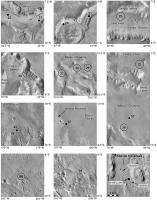
This is a page of illustrations of potential landing sites for Mars Surveyor 2001, from the second landing site workshop just before it was cancelled. I'm posting it to celebrate (almost) finishing the first draft of my Mars atlas and my upcoming vacation. The original plan for the mission was to carry a large rover similar to MER, and somewhere else I posted some proposed traverses for that. Then the rover was shrunk to Sojourner-class with a range of only about 1000 m, so most people didn't propose traverses. But there was one - from Nathan Bridges - which is included here. It's not a 'must-do' traverse, but a sample of what might be possible. Incidentally, trying to find that location was not simple. There are some serious flaws in the VIking image coordinates database, including its representation on the THEMIS Viking Image Map system. Sometimes the coordinates for late-mission high resolution frames are 2 or 3 degeees off. And what about Tim Parker's 'Ibishead Peninsula'? That's no Ibis, that's a rabbit! Phil
-------------------- ... because the Solar System ain't gonna map itself.
Also to be found posting similar content on https://mastodon.social/@PhilStooke Maps for download (free PDF: https://upload.wikimedia.org/wikipedia/comm...Cartography.pdf NOTE: everything created by me which I post on UMSF is considered to be in the public domain (NOT CC, public domain) |
|
|
|
|
|
 tuvas MSL landing sites Apr 5 2007, 11:27 PM
 monitorlizard Great to get the inside scoop on the MSL landing s... Apr 6 2007, 12:33 AM
 tuvas QUOTE (monitorlizard @ Apr 5 2007, 05:33 ... Apr 6 2007, 05:07 PM nprev Tuvas, are you allowed to post the locations of an... Apr 6 2007, 04:02 AM mcaplinger QUOTE (nprev @ Apr 5 2007, 09:02 PM) Tuva... Apr 6 2007, 04:08 AM Pavel I remember one of the requirement was that the lan... Apr 6 2007, 04:08 AM djellison The complete process is fully documented here
htt... Apr 6 2007, 08:29 AM Phil Stooke 33 sites were shortlisted from about 90 suggested ... Apr 6 2007, 11:38 AM elakdawalla Since HiROC doesn't have a handy index to land... Apr 6 2007, 05:19 PM tuvas QUOTE (elakdawalla @ Apr 6 2007, 10:19 AM... Apr 6 2007, 05:37 PM elakdawalla An updated list of MSL sites as seen from MRO, inc... May 2 2007, 11:20 PM lyford Wow - thanks Emily - this is incredibly helpful - ... Apr 6 2007, 05:50 PM algorimancer I vote for the Hellas location. Lowest point on M... Apr 6 2007, 06:54 PM nprev Me too; seems like that's where MSL might have... Apr 6 2007, 10:45 PM Greg Hullender Just as long as there's no actual risk of it g... Apr 7 2007, 03:50 AM SFJCody Surely one of the most important lessons from MER ... Apr 7 2007, 10:16 AM centsworth_II QUOTE (SFJCody @ Apr 7 2007, 06:16 AM) ..... Apr 7 2007, 03:09 PM babakm Although the Meridiani sites will be a "safer... Apr 7 2007, 01:34 PM SFJCody QUOTE (babakm @ Apr 7 2007, 02:34 PM) Alt... Apr 7 2007, 01:45 PM Greg Hullender QUOTE (SFJCody @ Apr 7 2007, 06:45 AM) . ... Apr 7 2007, 04:30 PM nprev That's a really good argument re "follow ... Apr 7 2007, 03:36 PM nprev Okay, that's the worst pun of the week...you g... Apr 7 2007, 08:05 PM edstrick Considering that a mission requirement for MSL is ... Apr 8 2007, 07:54 AM djellison MSL's a bit open ended really - some of the la... Apr 8 2007, 08:46 AM nprev Gotta love it...hopefully the 4th generation rover... Apr 8 2007, 03:14 PM AlexBlackwell For those playing along at home, the MSL Landing S... May 3 2007, 10:04 PM tuvas QUOTE (AlexBlackwell @ May 3 2007, 03:04 ... May 3 2007, 10:35 PM AlexBlackwell QUOTE (tuvas @ May 3 2007, 12:35 PM) Wow,... May 3 2007, 11:30 PM elakdawalla I think something more like "indurated soil... May 3 2007, 10:47 PM stewjack The Riding with Robots Podcast has an interview wi... May 4 2007, 05:08 PM Oren Iishi I'm surprised that no one has talked about lan... Jun 12 2007, 09:43 PM algorimancer Considering the moderately persuasive argument sup... Jun 17 2007, 03:51 PM ynyralmaen QUOTE (algorimancer @ Jun 17 2007, 04:51 ... Jun 18 2007, 10:39 AM algorimancer QUOTE (ynyralmaen @ Jun 18 2007, 05:39 AM... Jun 18 2007, 01:12 PM ynyralmaen QUOTE (algorimancer @ Jun 18 2007, 02:12 ... Jun 18 2007, 02:53 PM ngunn Agreed. In the absence of large scale drilling equ... Jun 18 2007, 09:35 AM AlexBlackwell QUOTE (ngunn @ Jun 17 2007, 11:35 PM) Agr... Jun 18 2007, 06:06 PM ngunn Aye, and the other one. Jun 18 2007, 07:59 PM Geographer Why does elevation matter in designing the rover? ... Jun 22 2007, 07:15 PM djellison The higher you go - the less air your parachute ha... Jun 22 2007, 07:17 PM AlexBlackwell You might want to take a look at the latest versio... Jun 22 2007, 07:18 PM edstrick The more pounds per square foot (grams per square ... Jun 23 2007, 05:01 AM PDP8E After looking at all the MRO landing site images a... Jul 13 2007, 03:25 PM Phil Stooke Elysium Planitia (AKA ice pack) might look like a ... Jul 13 2007, 03:53 PM climber QUOTE (Phil Stooke @ Jul 13 2007, 05:53 P... Jul 13 2007, 04:06 PM James Sorenson Depending on what NASA's "Major" fin... Aug 3 2008, 09:38 PM vjkane QUOTE (James Sorenson @ Aug 3 2008, 10:38... Aug 3 2008, 11:10 PM mcaplinger QUOTE (vjkane @ Aug 3 2008, 03:10 PM) I b... Aug 3 2008, 11:30 PM nprev Mike, could you go into more detail about the lat ... Aug 4 2008, 12:24 AM mcaplinger QUOTE (nprev @ Aug 3 2008, 04:24 PM) Mike... Aug 4 2008, 02:13 AM nprev QUOTE (mcaplinger @ Aug 3 2008, 06:13 PM)... Aug 4 2008, 09:41 PM James Sorenson For DTE, how far above or below the horizon at the... Aug 4 2008, 08:49 PM djellison PHX doesn't do DTE But Earth on Sol 69 is mo... Aug 4 2008, 09:27 PM James Sorenson I was saying DTE for MSL hypothetically if MSL wer... Aug 4 2008, 09:39 PM peter59 I wish nice reading !
Third MSL Landing Site W... Sep 17 2008, 08:30 PM ElkGroveDan That thing does NOT look stable. Sep 17 2008, 09:07 PM djellison WOW - more funky flight hardware!!
I hope... Sep 17 2008, 09:03 PM Bobby I found this article about The Potential MSL Site:... Sep 18 2008, 04:56 AM lyford C'mon Holden!!!! Sep 18 2008, 06:43 AM ustrax Looks like reactions weren't all the same... ... Sep 18 2008, 07:07 AM peter59 Ranking
Eberswalde 44,53
Holden ... Sep 18 2008, 08:00 AM Tman They are still recommendations. But could it means... Sep 18 2008, 08:56 AM ustrax QUOTE (Tman @ Sep 18 2008, 09:56 AM) They... Sep 18 2008, 09:30 AM climber QUOTE (Tman @ Sep 18 2008, 10:56 AM) MSL ... Sep 18 2008, 11:08 AM djellison Damn you HRSC - two observations of it, and neithe... Sep 18 2008, 10:20 AM ustrax QUOTE (djellison @ Sep 18 2008, 11:20 AM)... Sep 18 2008, 10:41 AM ngunn I've got a couple of simple (simplistic?) ques... Sep 18 2008, 10:48 AM JRehling QUOTE (ngunn @ Sep 18 2008, 03:48 AM) I... Sep 19 2008, 11:43 PM djellison There's plenty of PDF's on the meeting web... Sep 18 2008, 11:03 AM ngunn QUOTE (djellison @ Sep 18 2008, 12:03 PM)... Sep 18 2008, 12:04 PM djellison QUOTE (ngunn @ Sep 18 2008, 01:04 PM) Did... Sep 18 2008, 12:12 PM peter59 MSL landing site should be scientifically valuable... Sep 18 2008, 11:30 AM Tman QUOTE (peter59 @ Sep 18 2008, 01:30 PM) M... Sep 19 2008, 04:57 PM monitorlizard I like the geology of Holden Crater and was glad t... Sep 20 2008, 12:09 PM mcaplinger QUOTE (monitorlizard @ Sep 20 2008, 04:09... Sep 20 2008, 07:33 PM vjkane With the expectation that MSL will eventually fly,... Oct 5 2008, 12:27 AM Del Palmer JPL announces final 4 candidates:
http://www.jpl.... Nov 20 2008, 01:13 AM BrianL QUOTE (Del Palmer @ Nov 19 2008, 07:13 PM... Mar 28 2009, 02:40 PM ElkGroveDan Is this really news? or did I miss something? I ... Nov 20 2008, 01:24 AM mcaplinger QUOTE (ElkGroveDan @ Nov 19 2008, 05:24 P... Nov 20 2008, 01:39 AM Phil Stooke Not really! It only makes sense to take advan... Mar 29 2009, 12:57 AM HughFromAlice Just a thought.....
In the light of the MSL missi... Mar 29 2009, 02:06 PM centsworth_II QUOTE (HughFromAlice @ Mar 29 2009, 09:06... Mar 30 2009, 07:44 AM HughFromAlice QUOTE (centsworth_II @ Mar 30 2009, 05:14... Mar 30 2009, 11:17 AM Cruzeiro do Sul In 2000 Nasa choose to expand the envelop for MER ... Apr 2 2009, 11:08 AM djellison QUOTE (Cruzeiro do Sul @ Apr 2 2009, 12:0... Apr 2 2009, 11:20 AM Cruzeiro do Sul QUOTE (djellison @ Apr 2 2009, 11:20 AM) ... Apr 3 2009, 02:03 PM Nomadd22 QUOTE (Cruzeiro do Sul @ Apr 2 2009, 07:0... Jun 4 2009, 02:24 AM gpurcell QUOTE (Nomadd22 @ Jun 3 2009, 08:24 PM) D... Jun 4 2009, 05:19 PM RonJones I know the sites of the potential mud volcano that... Apr 10 2009, 03:48 PM BrianL If MSL is now going to be partially dependent on s... Jul 11 2009, 03:28 PM mcaplinger QUOTE (BrianL @ Jul 11 2009, 08:28 AM) If... Jul 11 2009, 04:00 PM nprev Skimmed the slides last night, and IIRC the main c... Jul 11 2009, 05:28 PM Phil Stooke Some news on the landing site front. A year ago a... Jan 8 2010, 02:58 PM PDP8E ...more musings on a caffeine powered Sunday night... Jul 26 2010, 01:56 AM vjkane QUOTE (PDP8E @ Jul 26 2010, 01:56 AM) ...... Jul 26 2010, 04:15 AM tharrison QUOTE (PDP8E @ Jul 25 2010, 05:56 PM) ...... Aug 3 2010, 12:03 AM Stu QUOTE (tharrison @ Aug 3 2010, 01:03 AM) ... Aug 3 2010, 05:25 AM Vultur Hoping for Holden or Eberswalde personally, for th... Aug 3 2010, 08:45 PM
tuvas QUOTE (monitorlizard @ Apr 5 2007, 05:33 ... Apr 6 2007, 05:07 PM nprev Tuvas, are you allowed to post the locations of an... Apr 6 2007, 04:02 AM mcaplinger QUOTE (nprev @ Apr 5 2007, 09:02 PM) Tuva... Apr 6 2007, 04:08 AM Pavel I remember one of the requirement was that the lan... Apr 6 2007, 04:08 AM djellison The complete process is fully documented here
htt... Apr 6 2007, 08:29 AM Phil Stooke 33 sites were shortlisted from about 90 suggested ... Apr 6 2007, 11:38 AM elakdawalla Since HiROC doesn't have a handy index to land... Apr 6 2007, 05:19 PM tuvas QUOTE (elakdawalla @ Apr 6 2007, 10:19 AM... Apr 6 2007, 05:37 PM elakdawalla An updated list of MSL sites as seen from MRO, inc... May 2 2007, 11:20 PM lyford Wow - thanks Emily - this is incredibly helpful - ... Apr 6 2007, 05:50 PM algorimancer I vote for the Hellas location. Lowest point on M... Apr 6 2007, 06:54 PM nprev Me too; seems like that's where MSL might have... Apr 6 2007, 10:45 PM Greg Hullender Just as long as there's no actual risk of it g... Apr 7 2007, 03:50 AM SFJCody Surely one of the most important lessons from MER ... Apr 7 2007, 10:16 AM centsworth_II QUOTE (SFJCody @ Apr 7 2007, 06:16 AM) ..... Apr 7 2007, 03:09 PM babakm Although the Meridiani sites will be a "safer... Apr 7 2007, 01:34 PM SFJCody QUOTE (babakm @ Apr 7 2007, 02:34 PM) Alt... Apr 7 2007, 01:45 PM Greg Hullender QUOTE (SFJCody @ Apr 7 2007, 06:45 AM) . ... Apr 7 2007, 04:30 PM nprev That's a really good argument re "follow ... Apr 7 2007, 03:36 PM nprev Okay, that's the worst pun of the week...you g... Apr 7 2007, 08:05 PM edstrick Considering that a mission requirement for MSL is ... Apr 8 2007, 07:54 AM djellison MSL's a bit open ended really - some of the la... Apr 8 2007, 08:46 AM nprev Gotta love it...hopefully the 4th generation rover... Apr 8 2007, 03:14 PM AlexBlackwell For those playing along at home, the MSL Landing S... May 3 2007, 10:04 PM tuvas QUOTE (AlexBlackwell @ May 3 2007, 03:04 ... May 3 2007, 10:35 PM AlexBlackwell QUOTE (tuvas @ May 3 2007, 12:35 PM) Wow,... May 3 2007, 11:30 PM elakdawalla I think something more like "indurated soil... May 3 2007, 10:47 PM stewjack The Riding with Robots Podcast has an interview wi... May 4 2007, 05:08 PM Oren Iishi I'm surprised that no one has talked about lan... Jun 12 2007, 09:43 PM algorimancer Considering the moderately persuasive argument sup... Jun 17 2007, 03:51 PM ynyralmaen QUOTE (algorimancer @ Jun 17 2007, 04:51 ... Jun 18 2007, 10:39 AM algorimancer QUOTE (ynyralmaen @ Jun 18 2007, 05:39 AM... Jun 18 2007, 01:12 PM ynyralmaen QUOTE (algorimancer @ Jun 18 2007, 02:12 ... Jun 18 2007, 02:53 PM ngunn Agreed. In the absence of large scale drilling equ... Jun 18 2007, 09:35 AM AlexBlackwell QUOTE (ngunn @ Jun 17 2007, 11:35 PM) Agr... Jun 18 2007, 06:06 PM ngunn Aye, and the other one. Jun 18 2007, 07:59 PM Geographer Why does elevation matter in designing the rover? ... Jun 22 2007, 07:15 PM djellison The higher you go - the less air your parachute ha... Jun 22 2007, 07:17 PM AlexBlackwell You might want to take a look at the latest versio... Jun 22 2007, 07:18 PM edstrick The more pounds per square foot (grams per square ... Jun 23 2007, 05:01 AM PDP8E After looking at all the MRO landing site images a... Jul 13 2007, 03:25 PM Phil Stooke Elysium Planitia (AKA ice pack) might look like a ... Jul 13 2007, 03:53 PM climber QUOTE (Phil Stooke @ Jul 13 2007, 05:53 P... Jul 13 2007, 04:06 PM James Sorenson Depending on what NASA's "Major" fin... Aug 3 2008, 09:38 PM vjkane QUOTE (James Sorenson @ Aug 3 2008, 10:38... Aug 3 2008, 11:10 PM mcaplinger QUOTE (vjkane @ Aug 3 2008, 03:10 PM) I b... Aug 3 2008, 11:30 PM nprev Mike, could you go into more detail about the lat ... Aug 4 2008, 12:24 AM mcaplinger QUOTE (nprev @ Aug 3 2008, 04:24 PM) Mike... Aug 4 2008, 02:13 AM nprev QUOTE (mcaplinger @ Aug 3 2008, 06:13 PM)... Aug 4 2008, 09:41 PM James Sorenson For DTE, how far above or below the horizon at the... Aug 4 2008, 08:49 PM djellison PHX doesn't do DTE But Earth on Sol 69 is mo... Aug 4 2008, 09:27 PM James Sorenson I was saying DTE for MSL hypothetically if MSL wer... Aug 4 2008, 09:39 PM peter59 I wish nice reading !
Third MSL Landing Site W... Sep 17 2008, 08:30 PM ElkGroveDan That thing does NOT look stable. Sep 17 2008, 09:07 PM djellison WOW - more funky flight hardware!!
I hope... Sep 17 2008, 09:03 PM Bobby I found this article about The Potential MSL Site:... Sep 18 2008, 04:56 AM lyford C'mon Holden!!!! Sep 18 2008, 06:43 AM ustrax Looks like reactions weren't all the same... ... Sep 18 2008, 07:07 AM peter59 Ranking
Eberswalde 44,53
Holden ... Sep 18 2008, 08:00 AM Tman They are still recommendations. But could it means... Sep 18 2008, 08:56 AM ustrax QUOTE (Tman @ Sep 18 2008, 09:56 AM) They... Sep 18 2008, 09:30 AM climber QUOTE (Tman @ Sep 18 2008, 10:56 AM) MSL ... Sep 18 2008, 11:08 AM djellison Damn you HRSC - two observations of it, and neithe... Sep 18 2008, 10:20 AM ustrax QUOTE (djellison @ Sep 18 2008, 11:20 AM)... Sep 18 2008, 10:41 AM ngunn I've got a couple of simple (simplistic?) ques... Sep 18 2008, 10:48 AM JRehling QUOTE (ngunn @ Sep 18 2008, 03:48 AM) I... Sep 19 2008, 11:43 PM djellison There's plenty of PDF's on the meeting web... Sep 18 2008, 11:03 AM ngunn QUOTE (djellison @ Sep 18 2008, 12:03 PM)... Sep 18 2008, 12:04 PM djellison QUOTE (ngunn @ Sep 18 2008, 01:04 PM) Did... Sep 18 2008, 12:12 PM peter59 MSL landing site should be scientifically valuable... Sep 18 2008, 11:30 AM Tman QUOTE (peter59 @ Sep 18 2008, 01:30 PM) M... Sep 19 2008, 04:57 PM monitorlizard I like the geology of Holden Crater and was glad t... Sep 20 2008, 12:09 PM mcaplinger QUOTE (monitorlizard @ Sep 20 2008, 04:09... Sep 20 2008, 07:33 PM vjkane With the expectation that MSL will eventually fly,... Oct 5 2008, 12:27 AM Del Palmer JPL announces final 4 candidates:
http://www.jpl.... Nov 20 2008, 01:13 AM BrianL QUOTE (Del Palmer @ Nov 19 2008, 07:13 PM... Mar 28 2009, 02:40 PM ElkGroveDan Is this really news? or did I miss something? I ... Nov 20 2008, 01:24 AM mcaplinger QUOTE (ElkGroveDan @ Nov 19 2008, 05:24 P... Nov 20 2008, 01:39 AM Phil Stooke Not really! It only makes sense to take advan... Mar 29 2009, 12:57 AM HughFromAlice Just a thought.....
In the light of the MSL missi... Mar 29 2009, 02:06 PM centsworth_II QUOTE (HughFromAlice @ Mar 29 2009, 09:06... Mar 30 2009, 07:44 AM HughFromAlice QUOTE (centsworth_II @ Mar 30 2009, 05:14... Mar 30 2009, 11:17 AM Cruzeiro do Sul In 2000 Nasa choose to expand the envelop for MER ... Apr 2 2009, 11:08 AM djellison QUOTE (Cruzeiro do Sul @ Apr 2 2009, 12:0... Apr 2 2009, 11:20 AM Cruzeiro do Sul QUOTE (djellison @ Apr 2 2009, 11:20 AM) ... Apr 3 2009, 02:03 PM Nomadd22 QUOTE (Cruzeiro do Sul @ Apr 2 2009, 07:0... Jun 4 2009, 02:24 AM gpurcell QUOTE (Nomadd22 @ Jun 3 2009, 08:24 PM) D... Jun 4 2009, 05:19 PM RonJones I know the sites of the potential mud volcano that... Apr 10 2009, 03:48 PM BrianL If MSL is now going to be partially dependent on s... Jul 11 2009, 03:28 PM mcaplinger QUOTE (BrianL @ Jul 11 2009, 08:28 AM) If... Jul 11 2009, 04:00 PM nprev Skimmed the slides last night, and IIRC the main c... Jul 11 2009, 05:28 PM Phil Stooke Some news on the landing site front. A year ago a... Jan 8 2010, 02:58 PM PDP8E ...more musings on a caffeine powered Sunday night... Jul 26 2010, 01:56 AM vjkane QUOTE (PDP8E @ Jul 26 2010, 01:56 AM) ...... Jul 26 2010, 04:15 AM tharrison QUOTE (PDP8E @ Jul 25 2010, 05:56 PM) ...... Aug 3 2010, 12:03 AM Stu QUOTE (tharrison @ Aug 3 2010, 01:03 AM) ... Aug 3 2010, 05:25 AM Vultur Hoping for Holden or Eberswalde personally, for th... Aug 3 2010, 08:45 PM |

|
Lo-Fi Version | Time is now: 26th September 2024 - 11:38 PM |
|
RULES AND GUIDELINES Please read the Forum Rules and Guidelines before posting. IMAGE COPYRIGHT |
OPINIONS AND MODERATION Opinions expressed on UnmannedSpaceflight.com are those of the individual posters and do not necessarily reflect the opinions of UnmannedSpaceflight.com or The Planetary Society. The all-volunteer UnmannedSpaceflight.com moderation team is wholly independent of The Planetary Society. The Planetary Society has no influence over decisions made by the UnmannedSpaceflight.com moderators. |
SUPPORT THE FORUM Unmannedspaceflight.com is funded by the Planetary Society. Please consider supporting our work and many other projects by donating to the Society or becoming a member. |
|