Titan's topography, strange.... |

Titan's topography, strange.... |
 Apr 12 2009, 12:44 PM Apr 12 2009, 12:44 PM
Post
#1
|
|
 Senior Member  Group: Moderator Posts: 2785 Joined: 10-November 06 From: Pasadena, CA Member No.: 1345 |
Recent article in Science by Zebker et al.:
Zebker et al. Science in press, "Size and Shape of Saturn's Moon Titan". doi: 10.1126/science.1168905 (published online April 2, 2009) Link to abstract (pay-for article): http://www.sciencemag.org/cgi/content/abstract/1168905 Article on spaceref discusses this paper: http://www.spaceref.com/news/viewpr.html?pid=27912 Figure 3 from the Science article is a global elevation map relative to barycenter. Key points of article:
"Xanadu seems to be systematically lower than other parts of the equatorial belt, and not uplifted like most mountainous areas on Earth." (quote from Fig. 3 caption in article) -Mike -------------------- Some higher resolution images available at my photostream: http://www.flickr.com/photos/31678681@N07/
|
 |
 
|
 |
|
Aug 25 2010, 02:02 AM
Post
#2
|
||||
|
Member Group: Members Posts: 708 Joined: 1-April 08 From: Minnesota ! Member No.: 4081 |
The recent http://photojournal.jpl.nasa.gov/target/Titan
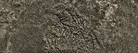
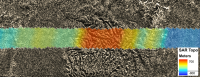
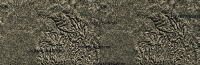
Planetary Photojournal images of Titans mountains (PIA 13330) are fascinating although well known to UMSF members. I was especially struck by the mountains north of Aaru when I first looked at the T16 radar swath! http://pirlwww.lpl.arizona.edu/~perry/RADAR/#T16 Although photojournal images are well done I thought one might tweak the raws some more to get a better idea of what these landforms look like. Below are 3 views done in photoshop elements using the northern most portion of PIA 13330. The last 3D image was created with a nice shareware program T3D-2D to 3D Image Converter from Cherry Cola Studios using the geometric and parallel 20 weight and shift of 1 reverse depth cue settings. (you'll have to cross your eyes and stare at the middle image until its clear to see the 3D effect !) These mountains seem highly eroded by fluvial processes. Some of the eroding rivers are still prominent, draining into the radar smooth plain to the north.
|
|||
|
|
|
|||
 Juramike Titan's topography Apr 12 2009, 12:44 PM
 Juramike Here's a cartooon showing how Xanadu could hav... Apr 12 2009, 03:32 PM Juramike The Science article is in reference to the Barycen... Apr 12 2009, 03:46 PM Juramike So now a Big Question:
Why are the poles wet, the ... Apr 12 2009, 04:00 PM ngunn Thanks for starting off a discussion on this. One ... Apr 12 2009, 08:24 PM
Juramike Here's a cartooon showing how Xanadu could hav... Apr 12 2009, 03:32 PM Juramike The Science article is in reference to the Barycen... Apr 12 2009, 03:46 PM Juramike So now a Big Question:
Why are the poles wet, the ... Apr 12 2009, 04:00 PM ngunn Thanks for starting off a discussion on this. One ... Apr 12 2009, 08:24 PM
 rlorenz QUOTE (ngunn @ Apr 12 2009, 04:24 PM) Tha... Apr 15 2009, 03:39 AM Doc Forgive my ignorance ngunn but exactly what was th... Apr 12 2009, 08:44 PM rlorenz QUOTE (Doc @ Apr 12 2009, 04:44 PM) Forgi... Apr 15 2009, 03:31 AM ngunn It came from RADAR reflectance observations of the... Apr 12 2009, 09:03 PM Juramike Nigel's right, the most recent evidence comes ... Apr 13 2009, 01:45 AM Juramike The channel drainage pattern in W Xanadu in the T1... Apr 13 2009, 02:07 AM ngunn On the ellipsoid vs. equipotential I'm happy t... Apr 15 2009, 09:34 AM Juramike Looking at channels in the RADAR Swaths, I haven... Apr 15 2009, 02:34 PM ngunn QUOTE (Juramike @ Apr 15 2009, 03:34 PM) ... Apr 15 2009, 03:06 PM Juramike QUOTE (rlorenz @ Apr 14 2009, 10:39 PM) T... Apr 15 2009, 03:18 PM ngunn Correct me if I'm wrong (again), but aren... Apr 15 2009, 03:44 PM Juramike If I understand this correctly, the dunes line up ... Apr 15 2009, 05:10 PM Juramike Two different wind regimes, but with one component... Apr 15 2009, 05:32 PM ngunn Mike I'm having trouble reconciling what you d... Apr 15 2009, 06:06 PM Juramike The maps show the linear dune orientation. The li... Apr 15 2009, 07:17 PM ngunn QUOTE (Juramike @ Apr 15 2009, 08:17 PM) ... Apr 15 2009, 07:36 PM Juramike If I remember correctly, the GCM wind field change... Apr 15 2009, 09:40 PM ngunn I'm just reading the transcript of the Titan s... Apr 15 2009, 09:59 PM Juramike From looking at RADAR images, it looks like the W ... Apr 16 2009, 02:45 AM ngunn QUOTE (Juramike @ Apr 16 2009, 03:45 AM) ... Apr 16 2009, 08:50 AM Juramike Bingo!
Tokano, T. Icarus 194 (2008) 243-262. ... Apr 16 2009, 02:46 AM ngunn A further thought on albedo-controlled winds. Sinc... Apr 16 2009, 10:01 AM ngunn Let's take this even further into the realm of... Apr 16 2009, 10:32 AM Juramike It also means that Xanadu, and processes that oper... Apr 16 2009, 11:31 AM ngunn Possibly, but it also restores - or rather preserv... Apr 16 2009, 11:38 AM Juramike QUOTE (ngunn @ Apr 16 2009, 06:38 AM) Pos... Apr 16 2009, 07:47 PM ngunn QUOTE (Juramike @ Apr 16 2009, 08:47 PM) ... Apr 16 2009, 09:52 PM Jason W Barnes QUOTE (ngunn @ Apr 16 2009, 04:38 AM) Pos... Apr 21 2009, 12:50 AM Jason W Barnes QUOTE (Jason W Barnes @ Apr 20 2009, 05:5... Apr 21 2009, 12:51 AM ngunn This thread has gone very quiet! In the meanti... Apr 20 2009, 11:07 AM ngunn A poem:
- - -
The Walrus and the Carpenter
Were w... Apr 20 2009, 02:10 PM Phil Stooke What's an order of magnitude among friends?
P... Apr 21 2009, 02:44 AM Juramike If Xanadu is "self-clearing" then the du... Apr 21 2009, 03:06 AM ngunn QUOTE (Juramike @ Apr 21 2009, 04:06 AM) ... Apr 21 2009, 08:06 AM ngunn I've just peformed an experiment which crudely... Apr 21 2009, 03:36 PM helvick Very nice work there ngunn - I was struggling to f... Apr 21 2009, 04:39 PM Jason W Barnes QUOTE (ngunn @ Apr 21 2009, 08:36 AM) I... Apr 22 2009, 07:45 PM stevesliva QUOTE (Jason W Barnes @ Apr 22 2009, 03:4... Apr 22 2009, 08:43 PM Jason W Barnes QUOTE (stevesliva @ Apr 22 2009, 01:43 PM... Apr 24 2009, 12:39 AM stevesliva QUOTE (Jason W Barnes @ Apr 23 2009, 08:3... Apr 24 2009, 02:27 PM ngunn QUOTE (Jason W Barnes @ Apr 22 2009, 08:4... Apr 22 2009, 09:37 PM ngunn Glad you liked it. Did you listen to the Takemitsu... Apr 21 2009, 09:54 PM ngunn After sleeping on it I'll now try to be more e... Apr 23 2009, 08:01 AM DFortes "No disrespect," to quote Jon Stewart, b... Apr 24 2009, 03:53 PM Juramike Link for Dorset, Acta Crystallographica B51 (1995)... Apr 24 2009, 06:40 PM Juramike Stiles et al. Icarus (2009) ASAP. "Determini... Apr 24 2009, 07:41 PM ngunn A stray thought on the dust-into-sand coagulation ... Apr 24 2009, 08:25 PM DFortes On the crystalline versus amorphous debate
There ... Apr 24 2009, 10:50 PM Juramike Good points.
F.M Flasar and R.K Achterberg, Phil.... Apr 24 2009, 11:55 PM Jason W Barnes QUOTE (Juramike @ Apr 24 2009, 04:55 PM) ... Apr 27 2009, 06:41 PM stevesliva QUOTE (Jason W Barnes @ Apr 27 2009, 02:4... Apr 27 2009, 09:39 PM ngunn The paper is in the current issue of 'Science... May 15 2009, 08:58 AM titanicrivers Wow such an incredible discussion ! It is tim... Sep 26 2009, 09:33 AM ngunn Brilliant, TR! I think that needs doing for a... Sep 26 2009, 09:44 AM titanicrivers QUOTE (ngunn @ Sep 26 2009, 04:44 AM) Bri... Sep 27 2009, 03:38 AM titanicrivers Here's a modified SARTopo map for Adiri and th... Sep 30 2009, 11:34 PM titanicrivers Here's a modified SARTopo map of the Huygens l... Sep 30 2009, 11:41 PM titanicrivers QUOTE (titanicrivers @ Sep 30 2009, 06:41... Oct 4 2009, 05:17 PM Juramike The "spooky dude" feature still puzzles ... Oct 4 2009, 06:00 PM ngunn Mike, I noticed that you had implied this in one o... Oct 4 2009, 07:15 PM titanicrivers I would also wonder if catastrophic flow was runni... Oct 4 2009, 07:58 PM ngunn Against that suggestion I would note that these ov... Oct 4 2009, 08:31 PM titanicrivers QUOTE (ngunn @ Oct 4 2009, 03:31 PM) Agai... Oct 6 2009, 08:20 PM Juramike Elevation shows the spooky dude formation is eleva... Oct 5 2009, 12:14 AM titanicrivers QUOTE (Juramike @ Oct 4 2009, 07:14 PM) E... Oct 5 2009, 01:49 AM ngunn QUOTE (Juramike @ Oct 5 2009, 01:14 AM) E... Oct 5 2009, 06:12 AM ngunn Interesting comparisons there for sure. I'd li... Oct 6 2009, 09:03 PM Juramike This oval feature shown above is part of the ... Oct 7 2009, 12:34 AM Juramike Graphic showing elevation trace (based only on th... Oct 7 2009, 01:11 AM ngunn Right! Got my position wrong, but the argument... Oct 7 2009, 07:28 AM titanicrivers QUOTE (ngunn @ Oct 7 2009, 02:28 AM) Righ... Oct 11 2009, 10:35 PM ngunn That's great: I so much prefer a sequence of s... Oct 11 2009, 11:10 PM Decepticon titanicrivers WOW! Oct 12 2009, 12:43 AM Juramike Nice overlay TR!
I'm not sure if the Spoo... Oct 12 2009, 02:35 AM Juramike Interesting how the channels go to the north into ... Aug 25 2010, 02:28 AM titanicrivers QUOTE (Juramike @ Aug 24 2010, 08:28 PM) ... Aug 25 2010, 07:08 AM Bill Harris TR--
Nifty topography. Reminds me of an uplifted... Aug 25 2010, 04:17 PM Decepticon ^ I tried to do the cross eyed thing and my result... Aug 26 2010, 02:21 AM titanicrivers I found this article via Wikipedia that may help y... Aug 26 2010, 08:51 AM titanicrivers Here is another 2D to 3D image that is relatively ... Sep 1 2010, 05:43 AM titanicrivers N00153307-9 composite with 2D to 3D conversion and... Sep 7 2010, 06:27 AM titanicrivers N Aaru Mountains, Titan. T16 SAR swath Part2, edi... Sep 10 2010, 08:31 AM titanicrivers Things are a little slow with Titan at the moment... Dec 6 2010, 06:56 PM algorimancer QUOTE (titanicrivers @ Dec 6 2010, 12:56 ... Dec 7 2010, 01:59 PM titanicrivers Agree the horizontal ridge is not compatible with ... Dec 11 2010, 07:46 AM AndyG My head's not wired to do cross-eyed 3d images... Dec 11 2010, 09:09 AM Juramike Yeah, my head's not wired for side by side vie... Dec 11 2010, 02:37 PM titanicrivers Here's a favorite spot on Titan for many of us... Feb 27 2011, 07:47 AM algorimancer Very subtle topography in this one.
Incidentally... Feb 28 2011, 04:11 PM titanicrivers T8 SAR part 2 contains lots of interesting topogra... May 9 2011, 05:13 AM titanicrivers The recent Photojournal image http://photojournal.... Jan 6 2013, 05:58 AM Ron Hobbs I just saw this on the JPL web site:
Cassini Sugg... Jan 8 2013, 07:33 PM stevesliva I bet there's some fantastic small-scale topog... Jan 8 2013, 10:45 PM Ron Hobbs Yeah, my mind is quivering with possibilities.
Ma... Jan 9 2013, 04:02 AM
rlorenz QUOTE (ngunn @ Apr 12 2009, 04:24 PM) Tha... Apr 15 2009, 03:39 AM Doc Forgive my ignorance ngunn but exactly what was th... Apr 12 2009, 08:44 PM rlorenz QUOTE (Doc @ Apr 12 2009, 04:44 PM) Forgi... Apr 15 2009, 03:31 AM ngunn It came from RADAR reflectance observations of the... Apr 12 2009, 09:03 PM Juramike Nigel's right, the most recent evidence comes ... Apr 13 2009, 01:45 AM Juramike The channel drainage pattern in W Xanadu in the T1... Apr 13 2009, 02:07 AM ngunn On the ellipsoid vs. equipotential I'm happy t... Apr 15 2009, 09:34 AM Juramike Looking at channels in the RADAR Swaths, I haven... Apr 15 2009, 02:34 PM ngunn QUOTE (Juramike @ Apr 15 2009, 03:34 PM) ... Apr 15 2009, 03:06 PM Juramike QUOTE (rlorenz @ Apr 14 2009, 10:39 PM) T... Apr 15 2009, 03:18 PM ngunn Correct me if I'm wrong (again), but aren... Apr 15 2009, 03:44 PM Juramike If I understand this correctly, the dunes line up ... Apr 15 2009, 05:10 PM Juramike Two different wind regimes, but with one component... Apr 15 2009, 05:32 PM ngunn Mike I'm having trouble reconciling what you d... Apr 15 2009, 06:06 PM Juramike The maps show the linear dune orientation. The li... Apr 15 2009, 07:17 PM ngunn QUOTE (Juramike @ Apr 15 2009, 08:17 PM) ... Apr 15 2009, 07:36 PM Juramike If I remember correctly, the GCM wind field change... Apr 15 2009, 09:40 PM ngunn I'm just reading the transcript of the Titan s... Apr 15 2009, 09:59 PM Juramike From looking at RADAR images, it looks like the W ... Apr 16 2009, 02:45 AM ngunn QUOTE (Juramike @ Apr 16 2009, 03:45 AM) ... Apr 16 2009, 08:50 AM Juramike Bingo!
Tokano, T. Icarus 194 (2008) 243-262. ... Apr 16 2009, 02:46 AM ngunn A further thought on albedo-controlled winds. Sinc... Apr 16 2009, 10:01 AM ngunn Let's take this even further into the realm of... Apr 16 2009, 10:32 AM Juramike It also means that Xanadu, and processes that oper... Apr 16 2009, 11:31 AM ngunn Possibly, but it also restores - or rather preserv... Apr 16 2009, 11:38 AM Juramike QUOTE (ngunn @ Apr 16 2009, 06:38 AM) Pos... Apr 16 2009, 07:47 PM ngunn QUOTE (Juramike @ Apr 16 2009, 08:47 PM) ... Apr 16 2009, 09:52 PM Jason W Barnes QUOTE (ngunn @ Apr 16 2009, 04:38 AM) Pos... Apr 21 2009, 12:50 AM Jason W Barnes QUOTE (Jason W Barnes @ Apr 20 2009, 05:5... Apr 21 2009, 12:51 AM ngunn This thread has gone very quiet! In the meanti... Apr 20 2009, 11:07 AM ngunn A poem:
- - -
The Walrus and the Carpenter
Were w... Apr 20 2009, 02:10 PM Phil Stooke What's an order of magnitude among friends?
P... Apr 21 2009, 02:44 AM Juramike If Xanadu is "self-clearing" then the du... Apr 21 2009, 03:06 AM ngunn QUOTE (Juramike @ Apr 21 2009, 04:06 AM) ... Apr 21 2009, 08:06 AM ngunn I've just peformed an experiment which crudely... Apr 21 2009, 03:36 PM helvick Very nice work there ngunn - I was struggling to f... Apr 21 2009, 04:39 PM Jason W Barnes QUOTE (ngunn @ Apr 21 2009, 08:36 AM) I... Apr 22 2009, 07:45 PM stevesliva QUOTE (Jason W Barnes @ Apr 22 2009, 03:4... Apr 22 2009, 08:43 PM Jason W Barnes QUOTE (stevesliva @ Apr 22 2009, 01:43 PM... Apr 24 2009, 12:39 AM stevesliva QUOTE (Jason W Barnes @ Apr 23 2009, 08:3... Apr 24 2009, 02:27 PM ngunn QUOTE (Jason W Barnes @ Apr 22 2009, 08:4... Apr 22 2009, 09:37 PM ngunn Glad you liked it. Did you listen to the Takemitsu... Apr 21 2009, 09:54 PM ngunn After sleeping on it I'll now try to be more e... Apr 23 2009, 08:01 AM DFortes "No disrespect," to quote Jon Stewart, b... Apr 24 2009, 03:53 PM Juramike Link for Dorset, Acta Crystallographica B51 (1995)... Apr 24 2009, 06:40 PM Juramike Stiles et al. Icarus (2009) ASAP. "Determini... Apr 24 2009, 07:41 PM ngunn A stray thought on the dust-into-sand coagulation ... Apr 24 2009, 08:25 PM DFortes On the crystalline versus amorphous debate
There ... Apr 24 2009, 10:50 PM Juramike Good points.
F.M Flasar and R.K Achterberg, Phil.... Apr 24 2009, 11:55 PM Jason W Barnes QUOTE (Juramike @ Apr 24 2009, 04:55 PM) ... Apr 27 2009, 06:41 PM stevesliva QUOTE (Jason W Barnes @ Apr 27 2009, 02:4... Apr 27 2009, 09:39 PM ngunn The paper is in the current issue of 'Science... May 15 2009, 08:58 AM titanicrivers Wow such an incredible discussion ! It is tim... Sep 26 2009, 09:33 AM ngunn Brilliant, TR! I think that needs doing for a... Sep 26 2009, 09:44 AM titanicrivers QUOTE (ngunn @ Sep 26 2009, 04:44 AM) Bri... Sep 27 2009, 03:38 AM titanicrivers Here's a modified SARTopo map for Adiri and th... Sep 30 2009, 11:34 PM titanicrivers Here's a modified SARTopo map of the Huygens l... Sep 30 2009, 11:41 PM titanicrivers QUOTE (titanicrivers @ Sep 30 2009, 06:41... Oct 4 2009, 05:17 PM Juramike The "spooky dude" feature still puzzles ... Oct 4 2009, 06:00 PM ngunn Mike, I noticed that you had implied this in one o... Oct 4 2009, 07:15 PM titanicrivers I would also wonder if catastrophic flow was runni... Oct 4 2009, 07:58 PM ngunn Against that suggestion I would note that these ov... Oct 4 2009, 08:31 PM titanicrivers QUOTE (ngunn @ Oct 4 2009, 03:31 PM) Agai... Oct 6 2009, 08:20 PM Juramike Elevation shows the spooky dude formation is eleva... Oct 5 2009, 12:14 AM titanicrivers QUOTE (Juramike @ Oct 4 2009, 07:14 PM) E... Oct 5 2009, 01:49 AM ngunn QUOTE (Juramike @ Oct 5 2009, 01:14 AM) E... Oct 5 2009, 06:12 AM ngunn Interesting comparisons there for sure. I'd li... Oct 6 2009, 09:03 PM Juramike This oval feature shown above is part of the ... Oct 7 2009, 12:34 AM Juramike Graphic showing elevation trace (based only on th... Oct 7 2009, 01:11 AM ngunn Right! Got my position wrong, but the argument... Oct 7 2009, 07:28 AM titanicrivers QUOTE (ngunn @ Oct 7 2009, 02:28 AM) Righ... Oct 11 2009, 10:35 PM ngunn That's great: I so much prefer a sequence of s... Oct 11 2009, 11:10 PM Decepticon titanicrivers WOW! Oct 12 2009, 12:43 AM Juramike Nice overlay TR!
I'm not sure if the Spoo... Oct 12 2009, 02:35 AM Juramike Interesting how the channels go to the north into ... Aug 25 2010, 02:28 AM titanicrivers QUOTE (Juramike @ Aug 24 2010, 08:28 PM) ... Aug 25 2010, 07:08 AM Bill Harris TR--
Nifty topography. Reminds me of an uplifted... Aug 25 2010, 04:17 PM Decepticon ^ I tried to do the cross eyed thing and my result... Aug 26 2010, 02:21 AM titanicrivers I found this article via Wikipedia that may help y... Aug 26 2010, 08:51 AM titanicrivers Here is another 2D to 3D image that is relatively ... Sep 1 2010, 05:43 AM titanicrivers N00153307-9 composite with 2D to 3D conversion and... Sep 7 2010, 06:27 AM titanicrivers N Aaru Mountains, Titan. T16 SAR swath Part2, edi... Sep 10 2010, 08:31 AM titanicrivers Things are a little slow with Titan at the moment... Dec 6 2010, 06:56 PM algorimancer QUOTE (titanicrivers @ Dec 6 2010, 12:56 ... Dec 7 2010, 01:59 PM titanicrivers Agree the horizontal ridge is not compatible with ... Dec 11 2010, 07:46 AM AndyG My head's not wired to do cross-eyed 3d images... Dec 11 2010, 09:09 AM Juramike Yeah, my head's not wired for side by side vie... Dec 11 2010, 02:37 PM titanicrivers Here's a favorite spot on Titan for many of us... Feb 27 2011, 07:47 AM algorimancer Very subtle topography in this one.
Incidentally... Feb 28 2011, 04:11 PM titanicrivers T8 SAR part 2 contains lots of interesting topogra... May 9 2011, 05:13 AM titanicrivers The recent Photojournal image http://photojournal.... Jan 6 2013, 05:58 AM Ron Hobbs I just saw this on the JPL web site:
Cassini Sugg... Jan 8 2013, 07:33 PM stevesliva I bet there's some fantastic small-scale topog... Jan 8 2013, 10:45 PM Ron Hobbs Yeah, my mind is quivering with possibilities.
Ma... Jan 9 2013, 04:02 AM |

|
Lo-Fi Version | Time is now: 26th September 2024 - 04:56 PM |
|
RULES AND GUIDELINES Please read the Forum Rules and Guidelines before posting. IMAGE COPYRIGHT |
OPINIONS AND MODERATION Opinions expressed on UnmannedSpaceflight.com are those of the individual posters and do not necessarily reflect the opinions of UnmannedSpaceflight.com or The Planetary Society. The all-volunteer UnmannedSpaceflight.com moderation team is wholly independent of The Planetary Society. The Planetary Society has no influence over decisions made by the UnmannedSpaceflight.com moderators. |
SUPPORT THE FORUM Unmannedspaceflight.com is funded by the Planetary Society. Please consider supporting our work and many other projects by donating to the Society or becoming a member. |
|