Opportunity Route Map |

Opportunity Route Map |
 Feb 11 2005, 08:11 AM Feb 11 2005, 08:11 AM
Post
#1
|
||
 The Insider  Group: Members Posts: 669 Joined: 3-May 04 Member No.: 73 |
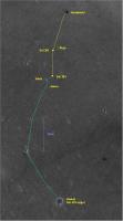
Here is an updated map of the road to Vostok.
Attached thumbnail(s)
|
|
 |
 
|
|
 |
|
Sep 11 2010, 04:17 PM
Post
#2
|
|
|
Solar System Cartographer Group: Members Posts: 10226 Joined: 5-April 05 From: Canada Member No.: 227 |
Don't forget that the map-projected images take into account only an idealized smooth surface - these are not orthophotos corrected for relief distortion. Meridiani Planum is smooth but not perfectly flat, and a discrepancy of a few hundred meters after 13000 m is probably quite reasonable. If you only look at one map-projected image it's easy to think it must have perfect geometry, but try overlaying one image on top of another and you'll find discrepancies at this level.
Phil -------------------- ... because the Solar System ain't gonna map itself.
Also to be found posting similar content on https://mastodon.social/@PhilStooke Maps for download (free PDF: https://upload.wikimedia.org/wikipedia/comm...Cartography.pdf NOTE: everything created by me which I post on UMSF is considered to be in the public domain (NOT CC, public domain) |
|
|
|
 Pando Opportunity Route Map Feb 11 2005, 08:11 AM
 marsophile My choice is the one on the left, second choice th... Aug 11 2010, 02:55 PM
 john_s I also vote for the one on the left. Nice to have... Aug 11 2010, 03:04 PM djellison And ET gets a guilt-free pass for attachment size,... Aug 11 2010, 03:12 PM Oersted QUOTE (djellison @ Aug 11 2010, 05:12 PM)... Aug 19 2010, 09:55 PM Sunspot QUOTE (Oersted @ Aug 19 2010, 10:55 PM) I... Aug 20 2010, 07:04 AM Stu QUOTE (Oersted @ Aug 19 2010, 10:55 PM) I... Aug 20 2010, 07:41 AM ElkGroveDan QUOTE (Oersted @ Aug 19 2010, 02:55 PM) I... Aug 20 2010, 02:54 PM elakdawalla I'm just piping up to say that I am in such a ... Aug 11 2010, 03:50 PM peter59 I vote for the 400x200 too, context is very useful... Aug 11 2010, 04:07 PM Stu Purely a selfish point of view, but the 400x200 wo... Aug 11 2010, 04:40 PM Tesheiner Ooook, so let's go with 400x200. Here's ho... Aug 11 2010, 05:51 PM MoreInput I think this fits perfect, you see the context aro... Aug 11 2010, 06:00 PM Bobby I agree with most of you regarding the 400 x 200 o... Aug 12 2010, 12:23 AM algorimancer Speaking of the route map kml version, is there a ... Aug 12 2010, 01:18 AM ElkGroveDan Yes. Hunt back, way back in this topic. We all a... Aug 12 2010, 01:54 AM SFJCody I'll need to make an update to that soon. How ... Aug 12 2010, 03:43 AM ElkGroveDan You've got about a year before we are off the ... Aug 12 2010, 05:45 AM Tesheiner So here we go with another map update, now for sol... Aug 12 2010, 08:57 AM climber Thank you Eduardo, I love this new version (and I ... Aug 12 2010, 09:11 AM Tesheiner Still struggling to post the proper KML file...
Me... Aug 12 2010, 09:44 AM algorimancer QUOTE (Tesheiner @ Aug 12 2010, 04:44 AM)... Aug 13 2010, 01:16 AM Syrinx QUOTE (Tesheiner @ Aug 12 2010, 02:44 AM)... Aug 13 2010, 11:30 PM Hungry4info QUOTE (Syrinx @ Aug 13 2010, 05:30 PM) I ... Aug 13 2010, 11:32 PM Tesheiner Sol 2329.
Aug 13 2010, 08:28 AM Phil Stooke You have to click on the text in the sidebar to ge... Aug 14 2010, 01:42 AM Tesheiner Map update for sol 2330.
Aug 14 2010, 10:15 AM Tesheiner Sol 2333.
Aug 17 2010, 08:12 PM Tesheiner Another 80m on sol 2334.
Aug 18 2010, 07:25 PM Tesheiner Here's the update for sol 2335.
Aug 19 2010, 02:21 PM machi QUOTE (Sunspot @ Aug 20 2010, 09:04 AM) I... Aug 20 2010, 05:03 PM Tesheiner I'm on 1024x768 too.
The point about auto-res... Aug 20 2010, 05:47 PM Tesheiner Last bump was quite small, just a few pixels on th... Aug 20 2010, 06:14 PM Tesheiner Searching for the last time I posted the whole pic... Aug 29 2010, 07:28 AM nprev Thanks, Eduardo!
Always fascinating to cor... Aug 29 2010, 08:45 AM Tesheiner Sol 2347. Less than 200m to the pavement.
Aug 31 2010, 08:26 PM Tesheiner Sol 2348.
Sep 2 2010, 07:45 AM ElkGroveDan Chit chat posts moved to the drive discussion topi... Sep 3 2010, 06:41 AM Tesheiner Sol 2349.
Sep 3 2010, 07:22 AM Vultur Is each grid square 100 x 100 meters? Sep 7 2010, 02:50 AM Tesheiner Yup.
Here's today's map update correspond... Sep 7 2010, 03:33 AM Tesheiner Here's the latest map update, with another km ... Sep 9 2010, 07:02 AM climber I played around with Google Earth as well as Eduar... Sep 11 2010, 10:34 AM Tesheiner What I can say about the grid is that it is based ... Sep 11 2010, 12:07 PM Floyd Climber--how great is the discrepancy? Putting a ... Sep 11 2010, 12:33 PM climber QUOTE (Floyd @ Sep 11 2010, 02:33 PM) Cli... Sep 11 2010, 12:54 PM climber I should have said Philthagoras is your friend... Sep 11 2010, 09:41 PM Tesheiner Sol 2358.
Sep 12 2010, 08:36 AM Tesheiner Here's a (late) update related to sol 2361. I ... Sep 17 2010, 03:29 PM Tesheiner Sol 2363.
Sep 18 2010, 09:17 AM Tesheiner Sol 2367.
Sep 21 2010, 02:43 PM Tesheiner Sol 2374.
Sep 28 2010, 03:33 PM Tesheiner Sol 2375.
Sep 29 2010, 03:13 PM Tesheiner Sol 2377.
Oct 1 2010, 04:49 PM climber Kinda playing around with the 13km South line, eh? Oct 1 2010, 05:36 PM Tesheiner And the 2km East too.
Oct 1 2010, 05:49 PM Phil Stooke Ouch! Stop it, you're making me crazy... Oct 1 2010, 05:52 PM fredk Seriously, I've often wondered something about... Oct 1 2010, 06:44 PM Tesheiner QUOTE (fredk @ Oct 1 2010, 08:44 PM) I... Oct 1 2010, 10:22 PM Phil Stooke A wee correction to our wonderful route maps...
R... Oct 2 2010, 08:23 PM ngunn QUOTE (Phil Stooke @ Oct 2 2010, 09:23 PM... Oct 2 2010, 09:31 PM Tesheiner Thanks for pointing that, Phil. Maps updated. Oct 2 2010, 09:04 PM Tesheiner Here's the update for sol 2379.
Oct 3 2010, 11:15 PM Tesheiner Here's a preliminary update for sol 2381. I... Oct 5 2010, 10:11 PM Tesheiner Sol 2382.
There're some data from sol 2383 ... Oct 7 2010, 09:12 PM Tesheiner A preliminary plot of Opportunity's position a... Oct 9 2010, 09:16 PM Stu It's like she's following a coastline, isn... Oct 9 2010, 09:46 PM ElkGroveDan QUOTE (Stu @ Oct 9 2010, 02:46 PM) It... Oct 9 2010, 10:51 PM Poolio If memory serves, someone, somewhere, once anticip... Oct 9 2010, 11:29 PM Tesheiner So we are back on track.
Rui, perhaps it's t... Oct 10 2010, 07:16 AM Tesheiner Here's an update corresponding to sol 2393 and... Oct 18 2010, 05:57 AM Tesheiner Today's drive was once again on the 100m range... Oct 20 2010, 06:00 AM Tesheiner Moved a few posts dealing with travelled distance ... Oct 20 2010, 03:47 PM jamescanvin The clock has just ticked past midnight and so sol... Oct 24 2010, 02:02 PM MoreInput Here's the latest map from the Ohio State Univ... Oct 26 2010, 05:25 PM Tesheiner And here's my version from sol 2401. The curre... Oct 26 2010, 06:29 PM jamescanvin At the bottom right of Tesh's map you can see ... Oct 26 2010, 07:18 PM Tesheiner Yes.
That's the reason why I posted a bigger ... Oct 26 2010, 07:29 PM ngunn QUOTE (Tesheiner @ Oct 26 2010, 08:29 PM)... Oct 26 2010, 09:15 PM djellison Remember - there is always the KML Oct 26 2010, 09:29 PM ngunn I know I'm at the back of the class but I won... Oct 26 2010, 10:15 PM ElkGroveDan Keyhole Markup Language Oct 26 2010, 10:39 PM djellison It's the file that ET has been attaching to ev... Oct 26 2010, 11:03 PM Stu This shows you what you can do with Google Earth a... Oct 26 2010, 11:29 PM ngunn Thanks all re KMLs. My system comes up with 'u... Oct 27 2010, 09:30 AM Tesheiner Here's the map update corresponding to sol 240... Oct 27 2010, 03:30 PM ngunn QUOTE (Tesheiner @ Oct 27 2010, 04:30 PM)... Oct 27 2010, 06:57 PM Stu Thanks, but I have to stress it's only because... Oct 27 2010, 10:14 AM Tesheiner Now that Opportunity has almost reached the flat p... Oct 29 2010, 11:43 AM MoreInput Cool. For those who want to follow the trek of opp... Oct 29 2010, 06:28 PM walfy QUOTE (MoreInput @ Oct 29 2010, 10:28 AM)... Oct 30 2010, 08:39 AM Tesheiner I'm currently using the overlay created while ... Oct 30 2010, 03:49 PM Astro0 ADMIN: Several unproductive posts moved to the ... Nov 2 2010, 11:23 AM Tesheiner There's still not enough images to confirm the... Nov 4 2010, 04:42 PM Tesheiner An updated version.
Nov 5 2010, 10:10 PM Tesheiner Sol 2412.
Nov 6 2010, 08:14 PM Tesheiner Map update corresponding to sol 2414; arrival at I... Nov 10 2010, 08:14 AM Tesheiner Here's the route map cropped around the sol 24... Nov 16 2010, 03:09 PM Tesheiner Sol 2424.
Nov 19 2010, 10:45 AM Tesheiner You may like to download these updated versions. I... Nov 19 2010, 06:33 PM
john_s I also vote for the one on the left. Nice to have... Aug 11 2010, 03:04 PM djellison And ET gets a guilt-free pass for attachment size,... Aug 11 2010, 03:12 PM Oersted QUOTE (djellison @ Aug 11 2010, 05:12 PM)... Aug 19 2010, 09:55 PM Sunspot QUOTE (Oersted @ Aug 19 2010, 10:55 PM) I... Aug 20 2010, 07:04 AM Stu QUOTE (Oersted @ Aug 19 2010, 10:55 PM) I... Aug 20 2010, 07:41 AM ElkGroveDan QUOTE (Oersted @ Aug 19 2010, 02:55 PM) I... Aug 20 2010, 02:54 PM elakdawalla I'm just piping up to say that I am in such a ... Aug 11 2010, 03:50 PM peter59 I vote for the 400x200 too, context is very useful... Aug 11 2010, 04:07 PM Stu Purely a selfish point of view, but the 400x200 wo... Aug 11 2010, 04:40 PM Tesheiner Ooook, so let's go with 400x200. Here's ho... Aug 11 2010, 05:51 PM MoreInput I think this fits perfect, you see the context aro... Aug 11 2010, 06:00 PM Bobby I agree with most of you regarding the 400 x 200 o... Aug 12 2010, 12:23 AM algorimancer Speaking of the route map kml version, is there a ... Aug 12 2010, 01:18 AM ElkGroveDan Yes. Hunt back, way back in this topic. We all a... Aug 12 2010, 01:54 AM SFJCody I'll need to make an update to that soon. How ... Aug 12 2010, 03:43 AM ElkGroveDan You've got about a year before we are off the ... Aug 12 2010, 05:45 AM Tesheiner So here we go with another map update, now for sol... Aug 12 2010, 08:57 AM climber Thank you Eduardo, I love this new version (and I ... Aug 12 2010, 09:11 AM Tesheiner Still struggling to post the proper KML file...
Me... Aug 12 2010, 09:44 AM algorimancer QUOTE (Tesheiner @ Aug 12 2010, 04:44 AM)... Aug 13 2010, 01:16 AM Syrinx QUOTE (Tesheiner @ Aug 12 2010, 02:44 AM)... Aug 13 2010, 11:30 PM Hungry4info QUOTE (Syrinx @ Aug 13 2010, 05:30 PM) I ... Aug 13 2010, 11:32 PM Tesheiner Sol 2329.
Aug 13 2010, 08:28 AM Phil Stooke You have to click on the text in the sidebar to ge... Aug 14 2010, 01:42 AM Tesheiner Map update for sol 2330.
Aug 14 2010, 10:15 AM Tesheiner Sol 2333.
Aug 17 2010, 08:12 PM Tesheiner Another 80m on sol 2334.
Aug 18 2010, 07:25 PM Tesheiner Here's the update for sol 2335.
Aug 19 2010, 02:21 PM machi QUOTE (Sunspot @ Aug 20 2010, 09:04 AM) I... Aug 20 2010, 05:03 PM Tesheiner I'm on 1024x768 too.
The point about auto-res... Aug 20 2010, 05:47 PM Tesheiner Last bump was quite small, just a few pixels on th... Aug 20 2010, 06:14 PM Tesheiner Searching for the last time I posted the whole pic... Aug 29 2010, 07:28 AM nprev Thanks, Eduardo!
Always fascinating to cor... Aug 29 2010, 08:45 AM Tesheiner Sol 2347. Less than 200m to the pavement.
Aug 31 2010, 08:26 PM Tesheiner Sol 2348.
Sep 2 2010, 07:45 AM ElkGroveDan Chit chat posts moved to the drive discussion topi... Sep 3 2010, 06:41 AM Tesheiner Sol 2349.
Sep 3 2010, 07:22 AM Vultur Is each grid square 100 x 100 meters? Sep 7 2010, 02:50 AM Tesheiner Yup.
Here's today's map update correspond... Sep 7 2010, 03:33 AM Tesheiner Here's the latest map update, with another km ... Sep 9 2010, 07:02 AM climber I played around with Google Earth as well as Eduar... Sep 11 2010, 10:34 AM Tesheiner What I can say about the grid is that it is based ... Sep 11 2010, 12:07 PM Floyd Climber--how great is the discrepancy? Putting a ... Sep 11 2010, 12:33 PM climber QUOTE (Floyd @ Sep 11 2010, 02:33 PM) Cli... Sep 11 2010, 12:54 PM climber I should have said Philthagoras is your friend... Sep 11 2010, 09:41 PM Tesheiner Sol 2358.
Sep 12 2010, 08:36 AM Tesheiner Here's a (late) update related to sol 2361. I ... Sep 17 2010, 03:29 PM Tesheiner Sol 2363.
Sep 18 2010, 09:17 AM Tesheiner Sol 2367.
Sep 21 2010, 02:43 PM Tesheiner Sol 2374.
Sep 28 2010, 03:33 PM Tesheiner Sol 2375.
Sep 29 2010, 03:13 PM Tesheiner Sol 2377.
Oct 1 2010, 04:49 PM climber Kinda playing around with the 13km South line, eh? Oct 1 2010, 05:36 PM Tesheiner And the 2km East too.
Oct 1 2010, 05:49 PM Phil Stooke Ouch! Stop it, you're making me crazy... Oct 1 2010, 05:52 PM fredk Seriously, I've often wondered something about... Oct 1 2010, 06:44 PM Tesheiner QUOTE (fredk @ Oct 1 2010, 08:44 PM) I... Oct 1 2010, 10:22 PM Phil Stooke A wee correction to our wonderful route maps...
R... Oct 2 2010, 08:23 PM ngunn QUOTE (Phil Stooke @ Oct 2 2010, 09:23 PM... Oct 2 2010, 09:31 PM Tesheiner Thanks for pointing that, Phil. Maps updated. Oct 2 2010, 09:04 PM Tesheiner Here's the update for sol 2379.
Oct 3 2010, 11:15 PM Tesheiner Here's a preliminary update for sol 2381. I... Oct 5 2010, 10:11 PM Tesheiner Sol 2382.
There're some data from sol 2383 ... Oct 7 2010, 09:12 PM Tesheiner A preliminary plot of Opportunity's position a... Oct 9 2010, 09:16 PM Stu It's like she's following a coastline, isn... Oct 9 2010, 09:46 PM ElkGroveDan QUOTE (Stu @ Oct 9 2010, 02:46 PM) It... Oct 9 2010, 10:51 PM Poolio If memory serves, someone, somewhere, once anticip... Oct 9 2010, 11:29 PM Tesheiner So we are back on track.
Rui, perhaps it's t... Oct 10 2010, 07:16 AM Tesheiner Here's an update corresponding to sol 2393 and... Oct 18 2010, 05:57 AM Tesheiner Today's drive was once again on the 100m range... Oct 20 2010, 06:00 AM Tesheiner Moved a few posts dealing with travelled distance ... Oct 20 2010, 03:47 PM jamescanvin The clock has just ticked past midnight and so sol... Oct 24 2010, 02:02 PM MoreInput Here's the latest map from the Ohio State Univ... Oct 26 2010, 05:25 PM Tesheiner And here's my version from sol 2401. The curre... Oct 26 2010, 06:29 PM jamescanvin At the bottom right of Tesh's map you can see ... Oct 26 2010, 07:18 PM Tesheiner Yes.
That's the reason why I posted a bigger ... Oct 26 2010, 07:29 PM ngunn QUOTE (Tesheiner @ Oct 26 2010, 08:29 PM)... Oct 26 2010, 09:15 PM djellison Remember - there is always the KML Oct 26 2010, 09:29 PM ngunn I know I'm at the back of the class but I won... Oct 26 2010, 10:15 PM ElkGroveDan Keyhole Markup Language Oct 26 2010, 10:39 PM djellison It's the file that ET has been attaching to ev... Oct 26 2010, 11:03 PM Stu This shows you what you can do with Google Earth a... Oct 26 2010, 11:29 PM ngunn Thanks all re KMLs. My system comes up with 'u... Oct 27 2010, 09:30 AM Tesheiner Here's the map update corresponding to sol 240... Oct 27 2010, 03:30 PM ngunn QUOTE (Tesheiner @ Oct 27 2010, 04:30 PM)... Oct 27 2010, 06:57 PM Stu Thanks, but I have to stress it's only because... Oct 27 2010, 10:14 AM Tesheiner Now that Opportunity has almost reached the flat p... Oct 29 2010, 11:43 AM MoreInput Cool. For those who want to follow the trek of opp... Oct 29 2010, 06:28 PM walfy QUOTE (MoreInput @ Oct 29 2010, 10:28 AM)... Oct 30 2010, 08:39 AM Tesheiner I'm currently using the overlay created while ... Oct 30 2010, 03:49 PM Astro0 ADMIN: Several unproductive posts moved to the ... Nov 2 2010, 11:23 AM Tesheiner There's still not enough images to confirm the... Nov 4 2010, 04:42 PM Tesheiner An updated version.
Nov 5 2010, 10:10 PM Tesheiner Sol 2412.
Nov 6 2010, 08:14 PM Tesheiner Map update corresponding to sol 2414; arrival at I... Nov 10 2010, 08:14 AM Tesheiner Here's the route map cropped around the sol 24... Nov 16 2010, 03:09 PM Tesheiner Sol 2424.
Nov 19 2010, 10:45 AM Tesheiner You may like to download these updated versions. I... Nov 19 2010, 06:33 PM |

|
Lo-Fi Version | Time is now: 22nd September 2024 - 06:02 PM |
|
RULES AND GUIDELINES Please read the Forum Rules and Guidelines before posting. IMAGE COPYRIGHT |
OPINIONS AND MODERATION Opinions expressed on UnmannedSpaceflight.com are those of the individual posters and do not necessarily reflect the opinions of UnmannedSpaceflight.com or The Planetary Society. The all-volunteer UnmannedSpaceflight.com moderation team is wholly independent of The Planetary Society. The Planetary Society has no influence over decisions made by the UnmannedSpaceflight.com moderators. |
SUPPORT THE FORUM Unmannedspaceflight.com is funded by the Planetary Society. Please consider supporting our work and many other projects by donating to the Society or becoming a member. |
|