Opportunity Route Map |

Opportunity Route Map |
 Feb 11 2005, 08:11 AM Feb 11 2005, 08:11 AM
Post
#501
|
||
 The Insider  Group: Members Posts: 669 Joined: 3-May 04 Member No.: 73 |
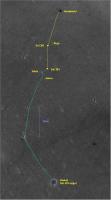
Here is an updated map of the road to Vostok.
Attached thumbnail(s)
|
|
 |
 
|
|
 |
|
Aug 8 2005, 10:54 AM
Post
#502
|
||
|
Senior Member Group: Moderator Posts: 4279 Joined: 19-April 05 From: .br at .es Member No.: 253 |
Mmmm,
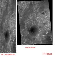
I'm not so confortable with my previous answer because I assumed you measured those 440m on the "wrong" image... After reviewing again the data for image R1500822 on the MSSS site (http://www.msss.com/moc_gallery/r10_r15/im...5/R1500822.html), I have found the following. Our assumption about 1.45 m/pixel for that image comes from the parameter: "Scaled pixel width: 1.45 meters" But R1500822 has actually two versions, one map-projected and another not. The "map-projected" version is the nice one we all have seen here and on another places. But those 1.45 m/pix refers to the NOT map-projected image i.e. the "raw" picture, and is actually the *horizontal* resolution of the picture. The vertical resolution is 1.45 * 0.43 (pixel aspect ratio) = 0.6235 m/pix. The map-projected image may have a different scale. (edited to include reference picture)
|
|
|
|
|
|
 Pando Opportunity Route Map Feb 11 2005, 08:11 AM
 TheChemist I would not worry, flight director updates have be... Aug 6 2005, 10:04 PM Bill Harris QUOTE Now, if distance from Erebus rim is really 1... Aug 6 2005, 10:46 PM Tesheiner > Suggestions?
Yes.
Phil's picture --- the... Aug 8 2005, 07:57 AM TheChemist I downloaded the raw R1500822 image from the MSSS ... Aug 8 2005, 12:06 PM djellison The raw (not projected) images show the huge verti... Aug 8 2005, 12:43 PM Tesheiner Yes, but which is the resolution of that image?
T... Aug 8 2005, 02:13 PM
TheChemist I would not worry, flight director updates have be... Aug 6 2005, 10:04 PM Bill Harris QUOTE Now, if distance from Erebus rim is really 1... Aug 6 2005, 10:46 PM Tesheiner > Suggestions?
Yes.
Phil's picture --- the... Aug 8 2005, 07:57 AM TheChemist I downloaded the raw R1500822 image from the MSSS ... Aug 8 2005, 12:06 PM djellison The raw (not projected) images show the huge verti... Aug 8 2005, 12:43 PM Tesheiner Yes, but which is the resolution of that image?
T... Aug 8 2005, 02:13 PM
 RNeuhaus QUOTE (Tesheiner @ Aug 8 2005, 09:13 AM)The d... Aug 9 2005, 10:59 PM Tesheiner QUOTE (RNeuhaus @ Aug 10 2005, 12:59 AM)Hello... Aug 10 2005, 07:09 AM djellison The odd thing is - the 0.7something m/pixel is act... Aug 8 2005, 02:55 PM dilo Thanks to all for great contribution!
Now I... Aug 9 2005, 08:18 PM TheChemist I told you the flight director was messing with us... Aug 9 2005, 09:42 PM CosmicRocker This apparently is the "Ice Cream Cone?... Aug 10 2005, 05:26 AM RNeuhaus QUOTE (CosmicRocker @ Aug 10 2005, 12:26 AM)T... Aug 10 2005, 02:20 PM Tesheiner I'm still amazed about how easy is to pick tho... Aug 11 2005, 11:21 AM abalone QUOTE (Tesheiner @ Aug 11 2005, 10:21 PM)I... Aug 11 2005, 11:49 AM paxdan QUOTE (Tesheiner @ Aug 11 2005, 12:21 PM)I... Aug 12 2005, 10:00 AM paxdan Aaaaaarrgggggggg* powers of ten someone please.
W... Aug 12 2005, 10:26 AM elakdawalla QUOTE (paxdan @ Aug 12 2005, 03:26 AM)Aaaaaar... Aug 12 2005, 01:59 PM dilo Here the updated vertical projections mosaic:
Pa... Aug 12 2005, 09:34 PM paxdan Cheers for the maps Dilo. It's great to know o... Aug 12 2005, 11:03 PM dilo This is an example of what can be done MGS+rout... Aug 13 2005, 06:15 AM ElkGroveDan Great work Dilo.
I'm starting to get the feel... Aug 13 2005, 04:51 PM RNeuhaus QUOTE (dilo @ Aug 13 2005, 01:15 AM)This is a... Aug 15 2005, 03:16 PM babakm First thing I thought after seeing dilo's pict... Aug 15 2005, 05:44 PM ElkGroveDan QUOTE (babakm @ Aug 15 2005, 05:44 PM)Some of... Aug 15 2005, 06:36 PM babakm Excuse the hatchet job, but I'm referring to t... Aug 15 2005, 08:46 PM dilo Really a good catch, babakm!
I made a Phil-O v... Aug 16 2005, 11:26 PM Tesheiner QUOTE (dilo @ Aug 17 2005, 01:26 AM)Another i... Aug 17 2005, 06:34 AM ilbasso Reminds me of comedian Steven Wright: "I hav... Aug 12 2005, 01:37 PM deglr6328 Ha! look at the image on the cover of Science ... Aug 12 2005, 04:59 PM Chmee QUOTE (deglr6328 @ Aug 12 2005, 12:59 PM)Ha... Aug 12 2005, 06:37 PM Bob Shaw QUOTE (Chmee @ Aug 12 2005, 07:37 PM)What is ... Aug 12 2005, 08:26 PM Tman Dilo, it seems you approach the (PovRay) master mo... Aug 13 2005, 09:21 AM Decepticon Dilo you have just made my mouth drop! That is... Aug 13 2005, 12:39 PM lyford DILO - Sweet fancy moses - that's beautiful... Aug 13 2005, 05:00 PM dilo Tman, I'm definitvely NOT Erwann!
I foll... Aug 13 2005, 10:09 PM Myran Thank you dilo for the great and informing image, ... Aug 13 2005, 08:58 PM dot.dk dilo, that thing is just a beauty!! Best r... Aug 13 2005, 10:55 PM dilo Thanks to dot.dk and all people appreciating this ... Aug 13 2005, 11:19 PM glennwsmith Dilo, let me add my voice to the chorus -- this is... Aug 14 2005, 01:17 AM Decepticon JPL should see this!! And learn. Aug 14 2005, 03:38 AM Phil Stooke Just another voice added to the chorus of praise f... Aug 14 2005, 06:15 AM Reckless Dilo's work get better and better.
Roy F Aug 14 2005, 06:47 AM jvandriel Dilo,
in the lower right corner of the Combo 2 ma... Aug 14 2005, 02:00 PM dilo QUOTE (jvandriel @ Aug 14 2005, 02:00 PM)Dilo... Aug 15 2005, 06:44 AM CosmicRocker I believe the rover drivers and route planners use... Aug 14 2005, 05:10 PM Bob Shaw QUOTE (CosmicRocker @ Aug 14 2005, 06:10 PM)I... Aug 14 2005, 06:17 PM mhoward QUOTE (Bob Shaw @ Aug 14 2005, 06:17 PM)Speak... Aug 14 2005, 09:27 PM RedSky QUOTE (mhoward @ Aug 14 2005, 04:27 PM)Re: La... Aug 14 2005, 09:44 PM Bob Shaw QUOTE (mhoward @ Aug 14 2005, 10:27 PM)MMB do... Aug 14 2005, 10:08 PM RedSky New (Aug 14) update from Steve at the Athena site:... Aug 14 2005, 08:59 PM Bill Harris The earlier discussions noted that Erebus and Terr... Aug 17 2005, 09:36 AM Marslauncher has anyone made a map as to how far we have driven... Aug 19 2005, 08:27 PM dilo QUOTE (Marslauncher @ Aug 19 2005, 08:27 PM)h... Aug 19 2005, 09:30 PM dilo Hope people will enjoy this divertissment: a new r... Aug 20 2005, 02:13 AM Cugel spacedaily
An Oppy update I have not yet seen any... Aug 19 2005, 09:03 PM remcook very fancy
you guys keep improving yourselves. ... Aug 20 2005, 10:22 AM ggoorden Has anyone an idea what this new picture on the Ex... Aug 20 2005, 10:44 AM Bob Shaw QUOTE (ggoorden @ Aug 20 2005, 11:44 AM)Has a... Aug 20 2005, 10:47 AM jvandriel A panoramic view of the Rat surface.
Taken with t... Aug 21 2005, 11:37 AM jvandriel A panoramic view of the same area before ratting.
... Aug 21 2005, 02:42 PM Phil Stooke Here's that view looking back towards Enduranc... Aug 21 2005, 04:32 PM dilo Impressive, Phil. I think you could be right on th... Aug 21 2005, 09:23 PM SigurRosFan Here's my updated traverse map.
http://xs43.x... Aug 24 2005, 12:28 PM dilo Me too ...
Edit: (corrected some imperfections) Aug 25 2005, 12:52 AM SigurRosFan And that's my updated traverse map (Sol 446 to... Aug 25 2005, 05:53 PM Sunspot Opportunity doesn't seem to be making much pro... Aug 25 2005, 06:05 PM antoniseb QUOTE (Sunspot @ Aug 25 2005, 01:05 PM)Opport... Aug 25 2005, 07:13 PM dilo OK, is done (hard to play with so many arguments..... Aug 25 2005, 08:58 PM Pando QUOTE (Sunspot @ Aug 25 2005, 11:05 AM)Opport... Aug 27 2005, 12:49 AM Sunspot QUOTE (Pando @ Aug 27 2005, 01:49 AM)yeah. Th... Aug 27 2005, 01:10 AM CosmicRocker dilo, it's been said many time before, but you... Aug 26 2005, 06:12 AM dilo QUOTE (CosmicRocker @ Aug 26 2005, 06:12 AM)d... Aug 26 2005, 06:24 AM Tesheiner QUOTE (CosmicRocker @ Aug 26 2005, 08:12 AM)I... Aug 26 2005, 07:15 AM babakm Dilo,
Any possibility of draping these over MOLA ... Aug 26 2005, 02:09 PM CosmicRocker QUOTE (Tesheiner @ Aug 26 2005, 01:15 AM)They... Aug 28 2005, 05:55 AM stevo Dilo, that is a great image. After all the excite... Aug 26 2005, 05:15 PM antoniseb Now THAT shows me where we are! Fantastic. I k... Aug 26 2005, 05:47 PM CosmicRocker If it truly is only a software issue, it should no... Aug 27 2005, 04:42 AM mike I would think Spirit would be having all the probl... Aug 27 2005, 05:25 AM general From
http://planetary.org/news/2005/mer-update_082... Aug 27 2005, 08:19 AM gregp1962 We've been 150 meters from Erebus for weeks no... Aug 27 2005, 05:58 PM Sunspot Imagine if Opportunity had not got stuck in Purgat... Aug 27 2005, 06:06 PM tty Now here's an interesting picture
Notice th... Aug 27 2005, 07:11 PM glennwsmith tty -- that IS some interesting strata. Don't... Aug 28 2005, 01:04 AM mike I thought the outcropping that Opportunity first s... Aug 28 2005, 02:32 AM CosmicRocker Actually, the geometry of those larger fractures i... Aug 28 2005, 05:21 AM dvandorn QUOTE (CosmicRocker @ Aug 28 2005, 12:21 AM).... Aug 28 2005, 12:12 PM tty QUOTE (dvandorn @ Aug 28 2005, 02:12 PM)These... Aug 28 2005, 05:55 PM CosmicRocker QUOTE (dvandorn @ Aug 28 2005, 06:12 AM)...
W... Aug 28 2005, 06:00 PM Decepticon Times like this I wish we had the ability to dig o... Aug 28 2005, 01:18 PM avkillick Are there any indications that the current glitch ... Aug 28 2005, 03:24 PM Sunspot QUOTE (avkillick @ Aug 28 2005, 04:24 PM)Are ... Aug 28 2005, 09:35 PM SFJCody The marswatch site shows no planned images for 567... Aug 28 2005, 09:44 PM Sunspot QUOTE (SFJCody @ Aug 28 2005, 10:44 PM)The ma... Aug 28 2005, 10:18 PM
RNeuhaus QUOTE (Tesheiner @ Aug 8 2005, 09:13 AM)The d... Aug 9 2005, 10:59 PM Tesheiner QUOTE (RNeuhaus @ Aug 10 2005, 12:59 AM)Hello... Aug 10 2005, 07:09 AM djellison The odd thing is - the 0.7something m/pixel is act... Aug 8 2005, 02:55 PM dilo Thanks to all for great contribution!
Now I... Aug 9 2005, 08:18 PM TheChemist I told you the flight director was messing with us... Aug 9 2005, 09:42 PM CosmicRocker This apparently is the "Ice Cream Cone?... Aug 10 2005, 05:26 AM RNeuhaus QUOTE (CosmicRocker @ Aug 10 2005, 12:26 AM)T... Aug 10 2005, 02:20 PM Tesheiner I'm still amazed about how easy is to pick tho... Aug 11 2005, 11:21 AM abalone QUOTE (Tesheiner @ Aug 11 2005, 10:21 PM)I... Aug 11 2005, 11:49 AM paxdan QUOTE (Tesheiner @ Aug 11 2005, 12:21 PM)I... Aug 12 2005, 10:00 AM paxdan Aaaaaarrgggggggg* powers of ten someone please.
W... Aug 12 2005, 10:26 AM elakdawalla QUOTE (paxdan @ Aug 12 2005, 03:26 AM)Aaaaaar... Aug 12 2005, 01:59 PM dilo Here the updated vertical projections mosaic:
Pa... Aug 12 2005, 09:34 PM paxdan Cheers for the maps Dilo. It's great to know o... Aug 12 2005, 11:03 PM dilo This is an example of what can be done MGS+rout... Aug 13 2005, 06:15 AM ElkGroveDan Great work Dilo.
I'm starting to get the feel... Aug 13 2005, 04:51 PM RNeuhaus QUOTE (dilo @ Aug 13 2005, 01:15 AM)This is a... Aug 15 2005, 03:16 PM babakm First thing I thought after seeing dilo's pict... Aug 15 2005, 05:44 PM ElkGroveDan QUOTE (babakm @ Aug 15 2005, 05:44 PM)Some of... Aug 15 2005, 06:36 PM babakm Excuse the hatchet job, but I'm referring to t... Aug 15 2005, 08:46 PM dilo Really a good catch, babakm!
I made a Phil-O v... Aug 16 2005, 11:26 PM Tesheiner QUOTE (dilo @ Aug 17 2005, 01:26 AM)Another i... Aug 17 2005, 06:34 AM ilbasso Reminds me of comedian Steven Wright: "I hav... Aug 12 2005, 01:37 PM deglr6328 Ha! look at the image on the cover of Science ... Aug 12 2005, 04:59 PM Chmee QUOTE (deglr6328 @ Aug 12 2005, 12:59 PM)Ha... Aug 12 2005, 06:37 PM Bob Shaw QUOTE (Chmee @ Aug 12 2005, 07:37 PM)What is ... Aug 12 2005, 08:26 PM Tman Dilo, it seems you approach the (PovRay) master mo... Aug 13 2005, 09:21 AM Decepticon Dilo you have just made my mouth drop! That is... Aug 13 2005, 12:39 PM lyford DILO - Sweet fancy moses - that's beautiful... Aug 13 2005, 05:00 PM dilo Tman, I'm definitvely NOT Erwann!
I foll... Aug 13 2005, 10:09 PM Myran Thank you dilo for the great and informing image, ... Aug 13 2005, 08:58 PM dot.dk dilo, that thing is just a beauty!! Best r... Aug 13 2005, 10:55 PM dilo Thanks to dot.dk and all people appreciating this ... Aug 13 2005, 11:19 PM glennwsmith Dilo, let me add my voice to the chorus -- this is... Aug 14 2005, 01:17 AM Decepticon JPL should see this!! And learn. Aug 14 2005, 03:38 AM Phil Stooke Just another voice added to the chorus of praise f... Aug 14 2005, 06:15 AM Reckless Dilo's work get better and better.
Roy F Aug 14 2005, 06:47 AM jvandriel Dilo,
in the lower right corner of the Combo 2 ma... Aug 14 2005, 02:00 PM dilo QUOTE (jvandriel @ Aug 14 2005, 02:00 PM)Dilo... Aug 15 2005, 06:44 AM CosmicRocker I believe the rover drivers and route planners use... Aug 14 2005, 05:10 PM Bob Shaw QUOTE (CosmicRocker @ Aug 14 2005, 06:10 PM)I... Aug 14 2005, 06:17 PM mhoward QUOTE (Bob Shaw @ Aug 14 2005, 06:17 PM)Speak... Aug 14 2005, 09:27 PM RedSky QUOTE (mhoward @ Aug 14 2005, 04:27 PM)Re: La... Aug 14 2005, 09:44 PM Bob Shaw QUOTE (mhoward @ Aug 14 2005, 10:27 PM)MMB do... Aug 14 2005, 10:08 PM RedSky New (Aug 14) update from Steve at the Athena site:... Aug 14 2005, 08:59 PM Bill Harris The earlier discussions noted that Erebus and Terr... Aug 17 2005, 09:36 AM Marslauncher has anyone made a map as to how far we have driven... Aug 19 2005, 08:27 PM dilo QUOTE (Marslauncher @ Aug 19 2005, 08:27 PM)h... Aug 19 2005, 09:30 PM dilo Hope people will enjoy this divertissment: a new r... Aug 20 2005, 02:13 AM Cugel spacedaily
An Oppy update I have not yet seen any... Aug 19 2005, 09:03 PM remcook very fancy
you guys keep improving yourselves. ... Aug 20 2005, 10:22 AM ggoorden Has anyone an idea what this new picture on the Ex... Aug 20 2005, 10:44 AM Bob Shaw QUOTE (ggoorden @ Aug 20 2005, 11:44 AM)Has a... Aug 20 2005, 10:47 AM jvandriel A panoramic view of the Rat surface.
Taken with t... Aug 21 2005, 11:37 AM jvandriel A panoramic view of the same area before ratting.
... Aug 21 2005, 02:42 PM Phil Stooke Here's that view looking back towards Enduranc... Aug 21 2005, 04:32 PM dilo Impressive, Phil. I think you could be right on th... Aug 21 2005, 09:23 PM SigurRosFan Here's my updated traverse map.
http://xs43.x... Aug 24 2005, 12:28 PM dilo Me too ...
Edit: (corrected some imperfections) Aug 25 2005, 12:52 AM SigurRosFan And that's my updated traverse map (Sol 446 to... Aug 25 2005, 05:53 PM Sunspot Opportunity doesn't seem to be making much pro... Aug 25 2005, 06:05 PM antoniseb QUOTE (Sunspot @ Aug 25 2005, 01:05 PM)Opport... Aug 25 2005, 07:13 PM dilo OK, is done (hard to play with so many arguments..... Aug 25 2005, 08:58 PM Pando QUOTE (Sunspot @ Aug 25 2005, 11:05 AM)Opport... Aug 27 2005, 12:49 AM Sunspot QUOTE (Pando @ Aug 27 2005, 01:49 AM)yeah. Th... Aug 27 2005, 01:10 AM CosmicRocker dilo, it's been said many time before, but you... Aug 26 2005, 06:12 AM dilo QUOTE (CosmicRocker @ Aug 26 2005, 06:12 AM)d... Aug 26 2005, 06:24 AM Tesheiner QUOTE (CosmicRocker @ Aug 26 2005, 08:12 AM)I... Aug 26 2005, 07:15 AM babakm Dilo,
Any possibility of draping these over MOLA ... Aug 26 2005, 02:09 PM CosmicRocker QUOTE (Tesheiner @ Aug 26 2005, 01:15 AM)They... Aug 28 2005, 05:55 AM stevo Dilo, that is a great image. After all the excite... Aug 26 2005, 05:15 PM antoniseb Now THAT shows me where we are! Fantastic. I k... Aug 26 2005, 05:47 PM CosmicRocker If it truly is only a software issue, it should no... Aug 27 2005, 04:42 AM mike I would think Spirit would be having all the probl... Aug 27 2005, 05:25 AM general From
http://planetary.org/news/2005/mer-update_082... Aug 27 2005, 08:19 AM gregp1962 We've been 150 meters from Erebus for weeks no... Aug 27 2005, 05:58 PM Sunspot Imagine if Opportunity had not got stuck in Purgat... Aug 27 2005, 06:06 PM tty Now here's an interesting picture
Notice th... Aug 27 2005, 07:11 PM glennwsmith tty -- that IS some interesting strata. Don't... Aug 28 2005, 01:04 AM mike I thought the outcropping that Opportunity first s... Aug 28 2005, 02:32 AM CosmicRocker Actually, the geometry of those larger fractures i... Aug 28 2005, 05:21 AM dvandorn QUOTE (CosmicRocker @ Aug 28 2005, 12:21 AM).... Aug 28 2005, 12:12 PM tty QUOTE (dvandorn @ Aug 28 2005, 02:12 PM)These... Aug 28 2005, 05:55 PM CosmicRocker QUOTE (dvandorn @ Aug 28 2005, 06:12 AM)...
W... Aug 28 2005, 06:00 PM Decepticon Times like this I wish we had the ability to dig o... Aug 28 2005, 01:18 PM avkillick Are there any indications that the current glitch ... Aug 28 2005, 03:24 PM Sunspot QUOTE (avkillick @ Aug 28 2005, 04:24 PM)Are ... Aug 28 2005, 09:35 PM SFJCody The marswatch site shows no planned images for 567... Aug 28 2005, 09:44 PM Sunspot QUOTE (SFJCody @ Aug 28 2005, 10:44 PM)The ma... Aug 28 2005, 10:18 PM |

|
Lo-Fi Version | Time is now: 20th June 2024 - 10:00 PM |
|
RULES AND GUIDELINES Please read the Forum Rules and Guidelines before posting. IMAGE COPYRIGHT |
OPINIONS AND MODERATION Opinions expressed on UnmannedSpaceflight.com are those of the individual posters and do not necessarily reflect the opinions of UnmannedSpaceflight.com or The Planetary Society. The all-volunteer UnmannedSpaceflight.com moderation team is wholly independent of The Planetary Society. The Planetary Society has no influence over decisions made by the UnmannedSpaceflight.com moderators. |
SUPPORT THE FORUM Unmannedspaceflight.com is funded by the Planetary Society. Please consider supporting our work and many other projects by donating to the Society or becoming a member. |
|