Voyager and Galileo Images of Ganymede, The Ganymede images and mosaics thread |

Voyager and Galileo Images of Ganymede, The Ganymede images and mosaics thread |
 May 18 2007, 09:43 PM May 18 2007, 09:43 PM
Post
#31
|
|||
 IMG to PNG GOD  Group: Moderator Posts: 2254 Joined: 19-February 04 From: Near fire and ice Member No.: 38 |
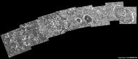
I've been processing some of the high resolution Galileo Ganymede images recently. As far as I know the two mosaics below have not appeared at the official websites (at least not in this form) so in a sense they are 'new'.
The first one was obtained during the G1 flyby in 1996. It covers a part of Memphis Facula which is centered at roughly 15°N, 132°W. The images were obtained at a distance of approximately 5000 km from Ganymede's center.
The second one was obtained during the G28 flyby in May 2000. It is centered near 14.5°S, 319.7°W. The images making up the mosaic were obtained at a distance of roughly 4500 km from Ganymede's center.
I will probably post more Ganymede mosaics later this month or next month. |
||
 |
 
|
||
 |
|
Oct 19 2010, 06:48 PM
Post
#32
|
|
|
IMG to PNG GOD Group: Moderator Posts: 2254 Joined: 19-February 04 From: Near fire and ice Member No.: 38 |
Great mosaic, especially when keeping in mind that it was made more than 10 years ago. Reminds me of when I made my first 'real' (and big) planetary map towards the end of the 20th century - it was of Ganymede. My computer was completely swamped, a lot of time was spent on calculation runs and it crashed several times. Now I could make a *much* bigger map with ease and much more quickly.
Needless to say, seeing the scripts would be interesting. There are some ISIS users here. |
|
|
|
|
Oct 19 2010, 07:11 PM
Post
#33
|
|
 Junior Member Group: Members Posts: 74 Joined: 9-October 10 From: Victoria, BC Member No.: 5483 |
QUOTE (Bjorn Jonsson @ Oct 19 2010, 11:48 AM)  Great mosaic, especially when keeping in mind that it was made more than 10 years ago. Reminds me of when I made my first 'real' (and big) planetary map towards the end of the 20th century - it was of Ganymede. My computer was completely swamped, a lot of time was spent on calculation runs and it crashed several times. Now I could make a *much* bigger map with ease and much more quickly. Funnily enough, I still have some email correspondence with you about making those maps  . .
|
|
|
|
 Bjorn Jonsson Voyager and Galileo Images of Ganymede May 18 2007, 09:43 PM
 OWW G2GSNIPPUR01 Nippur Sulcus
At the PPJ:
htt... Nov 13 2007, 11:49 PM
OWW G2GSNIPPUR01 Nippur Sulcus
At the PPJ:
htt... Nov 13 2007, 11:49 PM
 tedstryk And for a different angle, an distant J0 crescent ... Nov 13 2007, 11:59 PM OWW QUOTE (tedstryk @ Nov 14 2007, 12:59 AM) ... Nov 14 2007, 12:58 AM OWW G2GSTRANST01 Marius Regio
PPJ:
http://ph... Nov 14 2007, 12:00 AM OWW G2GSGRVLNS01 Byblus Sulcus
PPJ:
http://phot... Nov 14 2007, 12:06 AM OWW G8GSCALDRA01 Sippar Sulcus calderas
http://p... Nov 14 2007, 12:30 AM OWW G8GSFRACDK01 Southern border of Galileo Regi... Nov 14 2007, 12:35 AM OWW G8GSREGCON01 Marius Regio / Nippur Sulcus
ht... Nov 14 2007, 12:38 AM OWW G7GSNICHOL01 Nicholson Regio / Arbela Sulcu... Nov 14 2007, 12:48 AM OWW G8GSANSHAR01 Anshar Sulcus Nov 14 2007, 12:53 AM OWW G8GSRNGBAS01 Nov 14 2007, 12:57 AM OWW 28GSNICHOL02 Nicholson Regio context
28GSNICHO... Nov 14 2007, 04:42 PM tedstryk Here is a set that shows the problem with relying ... Nov 24 2007, 02:08 PM machi And here is something from my earliest works (i th... Nov 10 2009, 08:21 PM machi Ganymede's south pole region from Voyager 2. A... Oct 1 2010, 03:11 PM Hungry4info That's very nice! Oct 1 2010, 03:53 PM tedstryk Superb work! Oct 1 2010, 04:41 PM Juramike Beautiful! Oct 1 2010, 06:11 PM Bjorn Jonsson One more example of what can be done with the Voya... Oct 1 2010, 06:44 PM machi Thanks!
Yes, new reprocessed images from Voya... Oct 1 2010, 07:16 PM tedstryk Many were processed using a VAX. I can't even... Oct 1 2010, 08:11 PM jasedm Very impressive Machi.
The terrain in the far sout... Oct 1 2010, 08:23 PM Ian R Brilliant work, Daniel!
I'm beginning ... Oct 2 2010, 09:01 AM machi Ian, I have actually similar idea and in fact it... Oct 2 2010, 06:18 PM EDG This is a colour global view of Ganymede, taken us... Oct 18 2010, 03:36 AM DrShank >>I wish I could remember what specific imag... Oct 18 2010, 01:35 PM tedstryk One of my Ganymede mosaics uses that set with wide... Oct 18 2010, 04:28 PM EDG Only 18 images? Seemed like a lot more! (maybe... Oct 18 2010, 06:17 PM ugordan QUOTE (EDG @ Oct 18 2010, 08:17 PM) So ba... Oct 18 2010, 06:41 PM EDG Very nice! Thanks for doing that, I've of... Oct 18 2010, 07:23 PM DrShank its about as close to natural color (at high resol... Oct 18 2010, 11:46 PM EDG Hooray! I just managed to find all my old Gali... Oct 19 2010, 08:10 AM tasp Thanx!! Oct 19 2010, 05:32 PM elakdawalla Since the scripts are just text files and shouldn... Oct 19 2010, 06:26 PM EDG QUOTE (elakdawalla @ Oct 19 2010, 11:26 A... Oct 19 2010, 07:10 PM EDG This is the global mosaic of Ganymede's traili... Oct 19 2010, 07:17 PM EDG I was going to start a new thread for this but I t... Oct 20 2010, 07:37 AM tedstryk Cool. That looks like the set I used in this one.... Oct 20 2010, 05:20 PM EDG QUOTE (tedstryk @ Oct 20 2010, 10:20 AM) ... Oct 20 2010, 05:52 PM ugordan EDG, any idea why you have color shifting in the 3... Oct 20 2010, 06:20 PM EDG QUOTE (ugordan @ Oct 20 2010, 10:20 AM) E... Oct 20 2010, 06:47 PM ugordan QUOTE (EDG @ Oct 20 2010, 08:47 PM) Are y... Oct 20 2010, 06:51 PM EDG QUOTE (ugordan @ Oct 20 2010, 11:51 AM) Y... Oct 20 2010, 08:34 PM tedstryk I didn't notice that problem. Oct 20 2010, 08:37 PM tedstryk I am trying to find my notes...I did that image th... Oct 20 2010, 07:27 PM EDG To correct the blurriness (aesthetically anyway), ... Oct 20 2010, 07:40 AM EDG The next attempt is actually as close to true colo... Oct 20 2010, 07:49 AM ugordan QUOTE (EDG @ Oct 20 2010, 09:49 AM) All t... Oct 20 2010, 08:13 AM tedstryk QUOTE (ugordan @ Oct 20 2010, 09:13 AM) P... Oct 20 2010, 05:22 PM EDG And finally, just for kicks I tried an OGU image (... Oct 20 2010, 07:52 AM elakdawalla That is lovely. Is the shift from reddish tones t... Oct 21 2010, 03:29 AM tedstryk Toward the poles, it definitely seems grayer. Oct 21 2010, 03:34 AM ugordan It's supposed to be an irradiation thing - the... Oct 21 2010, 07:41 AM EDG I've found the scripts for the Voyager 1 mosai... Oct 21 2010, 05:24 AM DrShank thats right, those are the aggregate effects of sm... Oct 21 2010, 01:17 PM tedstryk Here is an alternate color mix.
Oct 21 2010, 08:30 PM ngunn Titan has veiled wonders and Io suppurates, but to... Oct 21 2010, 10:35 PM EDG QUOTE (ngunn @ Oct 21 2010, 03:35 PM) Tit... Oct 22 2010, 07:06 AM Decepticon EDG Have you done other moons?
Europa maybe? Nov 23 2010, 05:59 AM Bjorn Jonsson Here is a new global mosaic of Ganymede from Voyag... May 23 2016, 09:19 PM EDG Od's tonsils, Bjorn, that is amazing!
QU... May 25 2016, 10:03 PM Floyd Bjorn that is incredibly good. Thank you for your... May 23 2016, 09:50 PM jccwrt That's spectacular work, Bjorn! Well worth... May 25 2016, 04:48 AM jccwrt Voyager 2 got a great mosaic of the ~600 km wide G... May 26 2016, 02:37 AM JRehling This is all fantastic. Ganymede is truly one of th... May 26 2016, 06:50 PM 4throck QUOTE (JRehling @ May 26 2016, 07:50 PM) ... May 27 2016, 01:43 PM JRehling QUOTE (4throck @ May 27 2016, 06:43 AM) T... May 27 2016, 05:42 PM JRehling QUOTE (4throck @ May 27 2016, 06:43 AM) T... Mar 6 2017, 03:42 AM algorimancer QUOTE (JRehling @ Mar 5 2017, 09:42 PM) .... Mar 6 2017, 08:59 PM scalbers Bjorn's global view has an intriguing crystall... May 26 2016, 07:03 PM Bjorn Jonsson QUOTE (scalbers @ May 26 2016, 07:03 PM) ... May 26 2016, 10:21 PM JRehling Here's what Jupiter looked like the same night... May 27 2016, 05:37 PM jccwrt I've finished going through the Voyager 2 narr... May 27 2016, 08:29 PM JRehling WOW! That blew up to a much larger size than I... May 27 2016, 10:09 PM Bjorn Jonsson Awesome mosaics. The huge global mosaic is probabl... Jun 9 2016, 06:12 PM Ian R Stunning Bjorn! Can't believe this image... Jun 9 2016, 07:01 PM TrappistPlanets (staff team, sorry if this may be considered necro... Oct 11 2021, 07:34 PM stevesliva The paper mentions it's 'PC DEM' where... Oct 11 2021, 08:22 PM TrappistPlanets QUOTE (stevesliva @ Oct 11 2021, 08:22 PM... Oct 11 2021, 09:05 PM antipode Incredibly interesting paper on the ArXiv regardin... May 12 2022, 03:18 AM owlsyme Here is Voyager 1's Ganymede approach -
Fu... May 13 2022, 05:48 PM
tedstryk And for a different angle, an distant J0 crescent ... Nov 13 2007, 11:59 PM OWW QUOTE (tedstryk @ Nov 14 2007, 12:59 AM) ... Nov 14 2007, 12:58 AM OWW G2GSTRANST01 Marius Regio
PPJ:
http://ph... Nov 14 2007, 12:00 AM OWW G2GSGRVLNS01 Byblus Sulcus
PPJ:
http://phot... Nov 14 2007, 12:06 AM OWW G8GSCALDRA01 Sippar Sulcus calderas
http://p... Nov 14 2007, 12:30 AM OWW G8GSFRACDK01 Southern border of Galileo Regi... Nov 14 2007, 12:35 AM OWW G8GSREGCON01 Marius Regio / Nippur Sulcus
ht... Nov 14 2007, 12:38 AM OWW G7GSNICHOL01 Nicholson Regio / Arbela Sulcu... Nov 14 2007, 12:48 AM OWW G8GSANSHAR01 Anshar Sulcus Nov 14 2007, 12:53 AM OWW G8GSRNGBAS01 Nov 14 2007, 12:57 AM OWW 28GSNICHOL02 Nicholson Regio context
28GSNICHO... Nov 14 2007, 04:42 PM tedstryk Here is a set that shows the problem with relying ... Nov 24 2007, 02:08 PM machi And here is something from my earliest works (i th... Nov 10 2009, 08:21 PM machi Ganymede's south pole region from Voyager 2. A... Oct 1 2010, 03:11 PM Hungry4info That's very nice! Oct 1 2010, 03:53 PM tedstryk Superb work! Oct 1 2010, 04:41 PM Juramike Beautiful! Oct 1 2010, 06:11 PM Bjorn Jonsson One more example of what can be done with the Voya... Oct 1 2010, 06:44 PM machi Thanks!
Yes, new reprocessed images from Voya... Oct 1 2010, 07:16 PM tedstryk Many were processed using a VAX. I can't even... Oct 1 2010, 08:11 PM jasedm Very impressive Machi.
The terrain in the far sout... Oct 1 2010, 08:23 PM Ian R Brilliant work, Daniel!
I'm beginning ... Oct 2 2010, 09:01 AM machi Ian, I have actually similar idea and in fact it... Oct 2 2010, 06:18 PM EDG This is a colour global view of Ganymede, taken us... Oct 18 2010, 03:36 AM DrShank >>I wish I could remember what specific imag... Oct 18 2010, 01:35 PM tedstryk One of my Ganymede mosaics uses that set with wide... Oct 18 2010, 04:28 PM EDG Only 18 images? Seemed like a lot more! (maybe... Oct 18 2010, 06:17 PM ugordan QUOTE (EDG @ Oct 18 2010, 08:17 PM) So ba... Oct 18 2010, 06:41 PM EDG Very nice! Thanks for doing that, I've of... Oct 18 2010, 07:23 PM DrShank its about as close to natural color (at high resol... Oct 18 2010, 11:46 PM EDG Hooray! I just managed to find all my old Gali... Oct 19 2010, 08:10 AM tasp Thanx!! Oct 19 2010, 05:32 PM elakdawalla Since the scripts are just text files and shouldn... Oct 19 2010, 06:26 PM EDG QUOTE (elakdawalla @ Oct 19 2010, 11:26 A... Oct 19 2010, 07:10 PM EDG This is the global mosaic of Ganymede's traili... Oct 19 2010, 07:17 PM EDG I was going to start a new thread for this but I t... Oct 20 2010, 07:37 AM tedstryk Cool. That looks like the set I used in this one.... Oct 20 2010, 05:20 PM EDG QUOTE (tedstryk @ Oct 20 2010, 10:20 AM) ... Oct 20 2010, 05:52 PM ugordan EDG, any idea why you have color shifting in the 3... Oct 20 2010, 06:20 PM EDG QUOTE (ugordan @ Oct 20 2010, 10:20 AM) E... Oct 20 2010, 06:47 PM ugordan QUOTE (EDG @ Oct 20 2010, 08:47 PM) Are y... Oct 20 2010, 06:51 PM EDG QUOTE (ugordan @ Oct 20 2010, 11:51 AM) Y... Oct 20 2010, 08:34 PM tedstryk I didn't notice that problem. Oct 20 2010, 08:37 PM tedstryk I am trying to find my notes...I did that image th... Oct 20 2010, 07:27 PM EDG To correct the blurriness (aesthetically anyway), ... Oct 20 2010, 07:40 AM EDG The next attempt is actually as close to true colo... Oct 20 2010, 07:49 AM ugordan QUOTE (EDG @ Oct 20 2010, 09:49 AM) All t... Oct 20 2010, 08:13 AM tedstryk QUOTE (ugordan @ Oct 20 2010, 09:13 AM) P... Oct 20 2010, 05:22 PM EDG And finally, just for kicks I tried an OGU image (... Oct 20 2010, 07:52 AM elakdawalla That is lovely. Is the shift from reddish tones t... Oct 21 2010, 03:29 AM tedstryk Toward the poles, it definitely seems grayer. Oct 21 2010, 03:34 AM ugordan It's supposed to be an irradiation thing - the... Oct 21 2010, 07:41 AM EDG I've found the scripts for the Voyager 1 mosai... Oct 21 2010, 05:24 AM DrShank thats right, those are the aggregate effects of sm... Oct 21 2010, 01:17 PM tedstryk Here is an alternate color mix.
Oct 21 2010, 08:30 PM ngunn Titan has veiled wonders and Io suppurates, but to... Oct 21 2010, 10:35 PM EDG QUOTE (ngunn @ Oct 21 2010, 03:35 PM) Tit... Oct 22 2010, 07:06 AM Decepticon EDG Have you done other moons?
Europa maybe? Nov 23 2010, 05:59 AM Bjorn Jonsson Here is a new global mosaic of Ganymede from Voyag... May 23 2016, 09:19 PM EDG Od's tonsils, Bjorn, that is amazing!
QU... May 25 2016, 10:03 PM Floyd Bjorn that is incredibly good. Thank you for your... May 23 2016, 09:50 PM jccwrt That's spectacular work, Bjorn! Well worth... May 25 2016, 04:48 AM jccwrt Voyager 2 got a great mosaic of the ~600 km wide G... May 26 2016, 02:37 AM JRehling This is all fantastic. Ganymede is truly one of th... May 26 2016, 06:50 PM 4throck QUOTE (JRehling @ May 26 2016, 07:50 PM) ... May 27 2016, 01:43 PM JRehling QUOTE (4throck @ May 27 2016, 06:43 AM) T... May 27 2016, 05:42 PM JRehling QUOTE (4throck @ May 27 2016, 06:43 AM) T... Mar 6 2017, 03:42 AM algorimancer QUOTE (JRehling @ Mar 5 2017, 09:42 PM) .... Mar 6 2017, 08:59 PM scalbers Bjorn's global view has an intriguing crystall... May 26 2016, 07:03 PM Bjorn Jonsson QUOTE (scalbers @ May 26 2016, 07:03 PM) ... May 26 2016, 10:21 PM JRehling Here's what Jupiter looked like the same night... May 27 2016, 05:37 PM jccwrt I've finished going through the Voyager 2 narr... May 27 2016, 08:29 PM JRehling WOW! That blew up to a much larger size than I... May 27 2016, 10:09 PM Bjorn Jonsson Awesome mosaics. The huge global mosaic is probabl... Jun 9 2016, 06:12 PM Ian R Stunning Bjorn! Can't believe this image... Jun 9 2016, 07:01 PM TrappistPlanets (staff team, sorry if this may be considered necro... Oct 11 2021, 07:34 PM stevesliva The paper mentions it's 'PC DEM' where... Oct 11 2021, 08:22 PM TrappistPlanets QUOTE (stevesliva @ Oct 11 2021, 08:22 PM... Oct 11 2021, 09:05 PM antipode Incredibly interesting paper on the ArXiv regardin... May 12 2022, 03:18 AM owlsyme Here is Voyager 1's Ganymede approach -
Fu... May 13 2022, 05:48 PM |

|
Lo-Fi Version | Time is now: 26th September 2024 - 10:56 PM |
|
RULES AND GUIDELINES Please read the Forum Rules and Guidelines before posting. IMAGE COPYRIGHT |
OPINIONS AND MODERATION Opinions expressed on UnmannedSpaceflight.com are those of the individual posters and do not necessarily reflect the opinions of UnmannedSpaceflight.com or The Planetary Society. The all-volunteer UnmannedSpaceflight.com moderation team is wholly independent of The Planetary Society. The Planetary Society has no influence over decisions made by the UnmannedSpaceflight.com moderators. |
SUPPORT THE FORUM Unmannedspaceflight.com is funded by the Planetary Society. Please consider supporting our work and many other projects by donating to the Society or becoming a member. |
|