need help. how to uncompress .img files from magellan |

need help. how to uncompress .img files from magellan |
 Jan 6 2011, 11:33 PM Jan 6 2011, 11:33 PM
Post
#1
|
|
|
Junior Member  Group: Members Posts: 91 Joined: 21-August 06 Member No.: 1063 |
Hoping someone can help.
I am trying to uncompress the FMAP .img files which are part of magellans images of venus so I can use a converter program to convert them from sinusodal to cylindrical mapping. Things I do know is that I can just rename .img to .raw and open in photosho however the converter program newmap.exe which is an old dos program that is provided with the FMAP images requires I think the uncompressed .img files in order to convert sinusodal to cylindrical. I know the .raw didnt work. And I get error saying my .img files are compressed so it wont work. I know .img files are not cd or dvd image file or so I think becuase I could not open them in MagicISO If they were CD images I would think MagicISO would work but I may be wrong though. Anyone familiar with what I am trying to do. Any image processing guys out their do this with the magellan FMAPS? I figure the experts would be here. thanks |
 |
 
|
 |
|
Jan 7 2011, 09:08 PM
Post
#2
|
|||
 Administrator Group: Admin Posts: 5172 Joined: 4-August 05 From: Pasadena, CA, USA, Earth Member No.: 454 |
OK, I see your problem. The "Center of Projection" longitude has nothing to do with where the image is centered. It has to do with how the image is projected -- sinusoidal projection is a projection where only one line of longitude is vertical, and all other longitude lines are sinusoidal curves that converge toward the pole. Typically you want the center of projection to be the center longitude of the image, which is the mapaplanet default; there's only rare circumstances where you'd want to specify a different longitude (mostly having to do with building large mosaics out of several chunks).
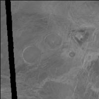
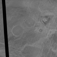
Here's how I find your volcanoes. Go to http://www.mapaplanet.org/explorer/venus.html. Pick Left-Look FMAPs. Click Advanced Options. You want a map centered at about 12 north, 8 east. So I'd put in 22, 2 for north and south and -2, 18 for east and west and click "Submit Changes." Oops, I get an image only 40 pixels square. No problem, I just bump the resolution up from 2 pix/deg to 100 pix/deg. Go away for a few minutes while it thinks. Curse when I come back and it tells me the "connection was reset." Bump the resolution to 50 pix/deg, and in 5 seconds I have a nice picture and I see those pancake volcanoes right in the middle. Use the mouse to draw a bounding box around the area I'm interested in and it automatically zooms, using the pixel extent of my previous map. I ask it for a gaussian stretch and bump the resolution up a bit more, to half the full resolution (704 pix/deg) and attached is what I get (warning, it's 4 MB). There is a link at lower right where you can view it as a JPEG; using the "shopping cart" you can download it in a lossless format. For illustration purposes here's one at 10% the full resolution.
Because the area you picked in this example sits on the equator, mapaplanet defaulted to showing it in simple cylindrical projection rather than sinusoidal, so the "center of projection" thing is completely meaningless, by the way. The whole process (including writing this post) took me about 7 min.
Attached thumbnail(s)
-------------------- My website - My Patreon - @elakdawalla on Twitter - Please support unmannedspaceflight.com by donating here.
|
||
|
|
|
||
|
Jan 7 2011, 11:54 PM
Post
#3
|
|
|
Junior Member Group: Members Posts: 91 Joined: 21-August 06 Member No.: 1063 |
Thank you. I found it.
Just out of curiosity did you think the pdsmaps was easier to use or does it make a difference in your mind given your expertise in the business? |
|
|
|
 ncc1701d need help. how to uncompress .img files from magellan Jan 6 2011, 11:33 PM
 djellison URL to the files in question? Jan 6 2011, 11:39 PM Phil Stooke .img files are not compressed, they are basically ... Jan 6 2011, 11:44 PM
 ncc1701d here is the link
ftp://pdsimage2.wr.usgs.gov/cdrom... Jan 7 2011, 12:42 AM elakdawalla I can't remember if the FMAPs are stored the s... Jan 7 2011, 12:31 AM siravan IMG files usually have either a text header or a s... Jan 7 2011, 12:46 AM ncc1701d concerning the other post i just noticed.
I used ... Jan 7 2011, 12:49 AM siravan Here is the first image (reduced to 25% of its ori... Jan 7 2011, 01:10 AM ncc1701d I appreciate all the input here so thank you all.
... Jan 7 2011, 01:37 AM siravan I recompiled newmap for XP using the source code c... Jan 7 2011, 02:34 AM ncc1701d for some reason I get my same message
*** ERROR *... Jan 7 2011, 03:00 AM siravan This is the file I got:
I'm not sure about ... Jan 7 2011, 03:13 AM ncc1701d I have to think on this now. Its not what I expect... Jan 7 2011, 03:24 AM siravan This is the correct image (I made a mistake in rea... Jan 7 2011, 03:58 AM ncc1701d are you just typing
newmap fl73n003.img fl73n003... Jan 7 2011, 06:36 AM ncc1701d thanks siravan
I got it to work. My problem was th... Jan 7 2011, 08:31 AM JohnVV if you want it is cylindrical you could grab them ... Jan 7 2011, 07:16 AM ncc1701d JohnVV
I used to use pdsmaps and it was very helpf... Jan 7 2011, 08:43 AM elakdawalla QUOTE (ncc1701d @ Jan 7 2011, 12:43 AM) m... Jan 7 2011, 05:03 PM ncc1701d ok here is little more clarification about what bu... Jan 7 2011, 08:54 PM JohnVV some of it still works
http://www.mapaplanet.org/e... Jan 7 2011, 10:27 AM Phil Stooke I agree, I use Map-a-Planet all the time and reall... Jan 7 2011, 08:44 PM JohnVV early on i liked pds-map-a-planet
for the simple ... Jan 8 2011, 12:27 AM
ncc1701d here is the link
ftp://pdsimage2.wr.usgs.gov/cdrom... Jan 7 2011, 12:42 AM elakdawalla I can't remember if the FMAPs are stored the s... Jan 7 2011, 12:31 AM siravan IMG files usually have either a text header or a s... Jan 7 2011, 12:46 AM ncc1701d concerning the other post i just noticed.
I used ... Jan 7 2011, 12:49 AM siravan Here is the first image (reduced to 25% of its ori... Jan 7 2011, 01:10 AM ncc1701d I appreciate all the input here so thank you all.
... Jan 7 2011, 01:37 AM siravan I recompiled newmap for XP using the source code c... Jan 7 2011, 02:34 AM ncc1701d for some reason I get my same message
*** ERROR *... Jan 7 2011, 03:00 AM siravan This is the file I got:
I'm not sure about ... Jan 7 2011, 03:13 AM ncc1701d I have to think on this now. Its not what I expect... Jan 7 2011, 03:24 AM siravan This is the correct image (I made a mistake in rea... Jan 7 2011, 03:58 AM ncc1701d are you just typing
newmap fl73n003.img fl73n003... Jan 7 2011, 06:36 AM ncc1701d thanks siravan
I got it to work. My problem was th... Jan 7 2011, 08:31 AM JohnVV if you want it is cylindrical you could grab them ... Jan 7 2011, 07:16 AM ncc1701d JohnVV
I used to use pdsmaps and it was very helpf... Jan 7 2011, 08:43 AM elakdawalla QUOTE (ncc1701d @ Jan 7 2011, 12:43 AM) m... Jan 7 2011, 05:03 PM ncc1701d ok here is little more clarification about what bu... Jan 7 2011, 08:54 PM JohnVV some of it still works
http://www.mapaplanet.org/e... Jan 7 2011, 10:27 AM Phil Stooke I agree, I use Map-a-Planet all the time and reall... Jan 7 2011, 08:44 PM JohnVV early on i liked pds-map-a-planet
for the simple ... Jan 8 2011, 12:27 AM |

|
Lo-Fi Version | Time is now: 26th September 2024 - 01:02 AM |
|
RULES AND GUIDELINES Please read the Forum Rules and Guidelines before posting. IMAGE COPYRIGHT |
OPINIONS AND MODERATION Opinions expressed on UnmannedSpaceflight.com are those of the individual posters and do not necessarily reflect the opinions of UnmannedSpaceflight.com or The Planetary Society. The all-volunteer UnmannedSpaceflight.com moderation team is wholly independent of The Planetary Society. The Planetary Society has no influence over decisions made by the UnmannedSpaceflight.com moderators. |
SUPPORT THE FORUM Unmannedspaceflight.com is funded by the Planetary Society. Please consider supporting our work and many other projects by donating to the Society or becoming a member. |
|