Rev 126 - Feb 4-22, 2010 - Mimas (main target), Tethys, Iapetus, Calypso and mutual events too |

 Unmanned Spaceflight.com > Outer Solar System > Saturn > Cassini Huygens > Cassini's ongoing mission and raw images
Rev 126 - Feb 4-22, 2010 - Mimas (main target), Tethys, Iapetus, Calypso and mutual events too |
 Feb 4 2010, 01:35 AM Feb 4 2010, 01:35 AM
Post
#101
|
|
|
Member  Group: Members Posts: 813 Joined: 29-December 05 From: NE Oh, USA Member No.: 627 |
All
closest look at Mimas ... 30 minutes after periapsis on 02/13/10 at 17:25 UTC http://ciclops.org/view/6188/Rev126 "Thirty minutes after periapse, ISS will perform a targeted encounter with Saturn's innermost large icy satellite, Mimas. The altitude for this encounter is 9,510 kilometers (5,910 miles) the closest Cassini has ever gotten to this cratered moon. For this encounter, ISS will acquire three mosaics along with another observation where ISS will be riding along with the Composite Infrared Spectrometer (CIRS). ISS' first mosaic of Mimas, GEOLOG001, will start 30 minutes after closest approach when Cassini is 14,800 kilometers (9,200 miles) away from Mimas. GEOLOG001 is a seven-frame, multi-spectral mosaic of the region surrounding the crater Herschel. Herschel, at 130 kilometers (80 miles) across, is the largest impact basin on Mimas, so large that it caused significant amounts of stress on the lithosphere of the small moon and so distinctive that it helped give the satellite the nickname, "The Death Star Moon." These high-resolution observations of the basin will be used to estimate the age of the crater. Scientists will count the number of smaller craters on the basin floor, compared to other regions on Mimas, to set limits on how old the basin can be. The second mosaic, GEOLOG002, will also be a seven-frame, multi-spectral mosaic, this time covering most of the visible surface of Mimas, shown above left. The best resolutions for these two observations will be 87 meters (285 feet) per pixel for GEOLOG001 and 191 meters (626 feet) per pixel GEOLOG002. Next, Cassini will ride-along with a CIRS FP3 temperature map of Mimas' day side, acquiring six narrow-angle-camera images during the scan. Finally, ISS will acquire a full-frame, multispectral observation (GLOCOL001) of Mimas' anti-Saturn hemisphere from a distance of 70,000 kilometers (44,000 miles). Saturn will provide a backdrop for this observation." Glorious Craig |
 |
 
|
 |
|
Jan 25 2011, 08:22 PM
Post
#102
|
||||||||
 IMG to PNG GOD Group: Moderator Posts: 2254 Joined: 19-February 04 From: Near fire and ice Member No.: 38 |
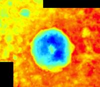
The data discussed earlier in this thread was released at the PDS Imaging Node early this month. Using this data I have now created a far more accurate DEM of Herschel than the one I mentioned earlier in the thread. The DEM is based on stereo imagery.
First a section of the DEM. It is fairly detailed but not flawless. It is slightly 'tilted', resulting in higher elevations east of Herschel than west. The DEM reveals that Herschel has a raised rim and the crater floor is deepest north and southeast of the central peak. Now I really need to find the time to learn how to correct the camera angles using ISIS (any tips?  ), the result should be a significant improvement in accuracy. ), the result should be a significant improvement in accuracy.
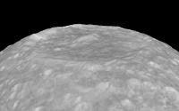
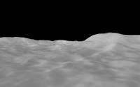
Then some quick and dirty test renders where data from a simple cylindrical map has been draped over the DEM. This map is a byproduct of the DEM creation process (it really is an orthophoto). First an overview of Herschel. The crater floor is obviously fairly flat and not curved:
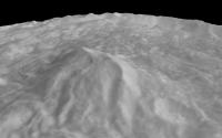
An overview of the central peak:
The view from the central peak summit looking east:
Looking northeast from a few km above the crater floor, the central peak is visible at right:
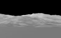
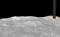
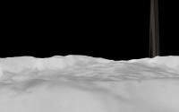
The field of view (FOV) in all of these images is 45° except for the last one where it is 50°. They are rendered using true vertical relief in all cases. I then decided to add Saturn just to see what things look like. Two quick test renders with a 50° FOV. First one looking east from above the western rim:
And looking east over the central peak:
|
|||||||
|
|
|
|||||||
 belleraphon1 Rev 126 - Feb 4-22, 2010 - Mimas (main target), Tethys Feb 4 2010, 01:35 AM
 Adam Hurcewicz
Here is Iapetus animation from 4 images:
http:/... Feb 22 2010, 02:25 PM Bjorn Jonsson Using Steve's updated map of Mimas I made a qu... Feb 24 2010, 12:01 AM elakdawalla Bjorn, it's very hard to mosaic the Mimas imag... Feb 24 2010, 12:42 AM Bjorn Jonsson Yes, the DEM enables this and the accuracy of the ... Feb 24 2010, 01:08 AM
Adam Hurcewicz
Here is Iapetus animation from 4 images:
http:/... Feb 22 2010, 02:25 PM Bjorn Jonsson Using Steve's updated map of Mimas I made a qu... Feb 24 2010, 12:01 AM elakdawalla Bjorn, it's very hard to mosaic the Mimas imag... Feb 24 2010, 12:42 AM Bjorn Jonsson Yes, the DEM enables this and the accuracy of the ... Feb 24 2010, 01:08 AM
 scalbers QUOTE (Bjorn Jonsson @ Feb 24 2010, 01:08... Feb 28 2010, 03:19 PM Bjorn Jonsson QUOTE (scalbers @ Feb 28 2010, 03:19 PM) ... Feb 28 2010, 04:09 PM Exploitcorporations Always so much to catch up on...fantastic DEM pers... Feb 24 2010, 06:26 AM scalbers QUOTE (Exploitcorporations @ Feb 24 2010, 06... Feb 28 2010, 09:21 PM 2of7 Hi everyone! This is my first post: usually I ... Feb 25 2010, 12:31 PM Floyd 2of7 Welcome to UMSF. Maybe a benevolent admin ca... Feb 25 2010, 01:25 PM 2of7 Thanks Floyd. My mistake! I saw the right cate... Feb 25 2010, 01:51 PM Juramike Welcome to UMSF, 2of7! Feb 25 2010, 02:32 PM 2of7 thanks to the admins to have moved my post!
H... Feb 25 2010, 02:43 PM DrShank here is the global color and high-resolution map o... Feb 25 2010, 05:02 PM scalbers QUOTE (DrShank @ Feb 25 2010, 05:02 PM) h... Feb 28 2010, 03:28 PM Juramike QUOTE (scalbers @ Feb 28 2010, 10:28 AM) ... Feb 28 2010, 04:28 PM 2of7 Mimas and Tethys crater:
http://www.flickr.com/p... Feb 25 2010, 05:06 PM Antdoghalo QUOTE (2of7 @ Feb 25 2010, 12:06 PM) Mima... Feb 28 2010, 01:36 AM Bjorn Jonsson Here is a Mimas/Herschel animation based on a slig... Feb 26 2010, 08:16 PM stevesliva Nice! The view from that peak would be tremen... Feb 27 2010, 12:35 AM Bjorn Jonsson The view to the NNW from the central peak summit m... Feb 28 2010, 12:39 AM stevesliva QUOTE (Bjorn Jonsson @ Feb 27 2010, 08:39... Feb 28 2010, 03:08 PM hendric Can someone create a comparison of Mimas and Tethy... Mar 1 2010, 04:47 PM Floyd See post 96 in this thread Mar 1 2010, 09:28 PM hendric Floyd,
I was hoping for a montage with the same ... Mar 1 2010, 09:42 PM Exploitcorporations QUOTE (scalbers @ Feb 28 2010, 01:21 PM) ... Mar 2 2010, 06:44 AM centsworth_II Based on the dimensions in this chart, I reduced t... Mar 2 2010, 09:30 AM DrShank I thought Id throw in my Herschel rendering, even ... Mar 2 2010, 01:55 PM Gladstoner . Mar 4 2010, 02:45 AM volcanopele These seem to be more related to the gravity field... Mar 4 2010, 03:28 AM ugordan http://www.ciclops.org/view_event/132/Clos..._Crat... Mar 29 2010, 07:22 PM Explorer1 That temperature map is just mystifying. Is it onl... Mar 29 2010, 07:44 PM DrShank QUOTE (Explorer1 @ Mar 29 2010, 01:44 PM)... Mar 29 2010, 09:28 PM Explorer1 QUOTE (DrShank @ Mar 29 2010, 02:28 PM) l... Mar 29 2010, 11:41 PM belleraphon1 Ain't no such thing as a boring world (worldle... Mar 29 2010, 10:13 PM volcanopele Which version of ISIS are you running? I use ISIS... Jan 25 2011, 08:44 PM Bjorn Jonsson I haven't been using ISIS a lot (I generated t... Jan 25 2011, 10:07 PM volcanopele Well, I know with ISIS2, you can use deltack to ad... Jan 25 2011, 11:12 PM Bjorn Jonsson I'm resurrecting this discussion because now I... Jun 4 2011, 12:54 AM DrShank Good work there on Herschel.
See also my posting... Jan 26 2011, 12:34 AM DrShank Just posted my Mimas Herschel video to Youtube... Mar 14 2011, 03:18 PM Bjorn Jonsson This is an experimental Herschel animation:
http:... Aug 28 2011, 11:47 PM Roby72 Björn, excellent animation !
...I think that ... Aug 29 2011, 10:21 PM Hungry4info Mimas has a slightly inclined orbit IIRC. Aug 29 2011, 10:23 PM machi It looks like movie from Kaguya's HD camera, e... Sep 1 2011, 09:49 PM Phil Stooke Great job! And while looking at it I saw your... Sep 1 2011, 11:26 PM Bjorn Jonsson This is not unexpected as I used your shape model ... Sep 2 2011, 03:23 PM Phil Stooke It may be that the small Jovian satellites were lo... Sep 2 2011, 03:45 PM john_s Beautiful, Bjorn!
It immediately reminded me ... Sep 2 2011, 07:16 PM Bjorn Jonsson Wow, I wasn't even aware there was an opening ... Sep 3 2011, 01:30 AM
scalbers QUOTE (Bjorn Jonsson @ Feb 24 2010, 01:08... Feb 28 2010, 03:19 PM Bjorn Jonsson QUOTE (scalbers @ Feb 28 2010, 03:19 PM) ... Feb 28 2010, 04:09 PM Exploitcorporations Always so much to catch up on...fantastic DEM pers... Feb 24 2010, 06:26 AM scalbers QUOTE (Exploitcorporations @ Feb 24 2010, 06... Feb 28 2010, 09:21 PM 2of7 Hi everyone! This is my first post: usually I ... Feb 25 2010, 12:31 PM Floyd 2of7 Welcome to UMSF. Maybe a benevolent admin ca... Feb 25 2010, 01:25 PM 2of7 Thanks Floyd. My mistake! I saw the right cate... Feb 25 2010, 01:51 PM Juramike Welcome to UMSF, 2of7! Feb 25 2010, 02:32 PM 2of7 thanks to the admins to have moved my post!
H... Feb 25 2010, 02:43 PM DrShank here is the global color and high-resolution map o... Feb 25 2010, 05:02 PM scalbers QUOTE (DrShank @ Feb 25 2010, 05:02 PM) h... Feb 28 2010, 03:28 PM Juramike QUOTE (scalbers @ Feb 28 2010, 10:28 AM) ... Feb 28 2010, 04:28 PM 2of7 Mimas and Tethys crater:
http://www.flickr.com/p... Feb 25 2010, 05:06 PM Antdoghalo QUOTE (2of7 @ Feb 25 2010, 12:06 PM) Mima... Feb 28 2010, 01:36 AM Bjorn Jonsson Here is a Mimas/Herschel animation based on a slig... Feb 26 2010, 08:16 PM stevesliva Nice! The view from that peak would be tremen... Feb 27 2010, 12:35 AM Bjorn Jonsson The view to the NNW from the central peak summit m... Feb 28 2010, 12:39 AM stevesliva QUOTE (Bjorn Jonsson @ Feb 27 2010, 08:39... Feb 28 2010, 03:08 PM hendric Can someone create a comparison of Mimas and Tethy... Mar 1 2010, 04:47 PM Floyd See post 96 in this thread Mar 1 2010, 09:28 PM hendric Floyd,
I was hoping for a montage with the same ... Mar 1 2010, 09:42 PM Exploitcorporations QUOTE (scalbers @ Feb 28 2010, 01:21 PM) ... Mar 2 2010, 06:44 AM centsworth_II Based on the dimensions in this chart, I reduced t... Mar 2 2010, 09:30 AM DrShank I thought Id throw in my Herschel rendering, even ... Mar 2 2010, 01:55 PM Gladstoner . Mar 4 2010, 02:45 AM volcanopele These seem to be more related to the gravity field... Mar 4 2010, 03:28 AM ugordan http://www.ciclops.org/view_event/132/Clos..._Crat... Mar 29 2010, 07:22 PM Explorer1 That temperature map is just mystifying. Is it onl... Mar 29 2010, 07:44 PM DrShank QUOTE (Explorer1 @ Mar 29 2010, 01:44 PM)... Mar 29 2010, 09:28 PM Explorer1 QUOTE (DrShank @ Mar 29 2010, 02:28 PM) l... Mar 29 2010, 11:41 PM belleraphon1 Ain't no such thing as a boring world (worldle... Mar 29 2010, 10:13 PM volcanopele Which version of ISIS are you running? I use ISIS... Jan 25 2011, 08:44 PM Bjorn Jonsson I haven't been using ISIS a lot (I generated t... Jan 25 2011, 10:07 PM volcanopele Well, I know with ISIS2, you can use deltack to ad... Jan 25 2011, 11:12 PM Bjorn Jonsson I'm resurrecting this discussion because now I... Jun 4 2011, 12:54 AM DrShank Good work there on Herschel.
See also my posting... Jan 26 2011, 12:34 AM DrShank Just posted my Mimas Herschel video to Youtube... Mar 14 2011, 03:18 PM Bjorn Jonsson This is an experimental Herschel animation:
http:... Aug 28 2011, 11:47 PM Roby72 Björn, excellent animation !
...I think that ... Aug 29 2011, 10:21 PM Hungry4info Mimas has a slightly inclined orbit IIRC. Aug 29 2011, 10:23 PM machi It looks like movie from Kaguya's HD camera, e... Sep 1 2011, 09:49 PM Phil Stooke Great job! And while looking at it I saw your... Sep 1 2011, 11:26 PM Bjorn Jonsson This is not unexpected as I used your shape model ... Sep 2 2011, 03:23 PM Phil Stooke It may be that the small Jovian satellites were lo... Sep 2 2011, 03:45 PM john_s Beautiful, Bjorn!
It immediately reminded me ... Sep 2 2011, 07:16 PM Bjorn Jonsson Wow, I wasn't even aware there was an opening ... Sep 3 2011, 01:30 AM |

|
Lo-Fi Version | Time is now: 26th September 2024 - 08:42 PM |
|
RULES AND GUIDELINES Please read the Forum Rules and Guidelines before posting. IMAGE COPYRIGHT |
OPINIONS AND MODERATION Opinions expressed on UnmannedSpaceflight.com are those of the individual posters and do not necessarily reflect the opinions of UnmannedSpaceflight.com or The Planetary Society. The all-volunteer UnmannedSpaceflight.com moderation team is wholly independent of The Planetary Society. The Planetary Society has no influence over decisions made by the UnmannedSpaceflight.com moderators. |
SUPPORT THE FORUM Unmannedspaceflight.com is funded by the Planetary Society. Please consider supporting our work and many other projects by donating to the Society or becoming a member. |
|