South Pole in 3D |

South Pole in 3D |
 Apr 7 2011, 03:13 PM Apr 7 2011, 03:13 PM
Post
#1
|
|||
|
Newbie  Group: Members Posts: 2 Joined: 16-November 10 From: France Member No.: 5526 |
Hello,
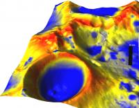
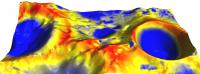
this is the first time I post on this forum. I would like to take the opportunity to thank you all for the inspiration you provided with your beautiful images and excellent work. After perusing the forums for a while I decided to start producing some planetary maps for some research project I was involved with and because it is really cool! I used the LOLA grided release and ISIS3 to read the LOLA files and produce .cub files. I used GRASS GIS to read these files (reads directly cub files). I then made an overlay from the illumination map that LROC team made for the Lunar South Pole. LROC SP Illumination Map . Finally, I used the nviz function of GRASS to tranform the LOLA data in 3D and overlay the illumination map as a "red to blue" colormap. So in these pictures, red means more illumination and blue means less illumination. The scale can be seen on the first map. I attach two of the images. hope you like it best regards Emmanouil
Attached thumbnail(s)
|
||
 |
 
|
||
 |
|
Apr 7 2011, 04:07 PM
Post
#2
|
|
|
Solar System Cartographer Group: Members Posts: 10189 Joined: 5-April 05 From: Canada Member No.: 227 |
These are very nice, and I congratulate you for doing such a good job.
One thing though - there seems to be a slight offset between the topography and the illumination shading. The red bands of maximum illumination should run over the very tops of all the ridges and crater rims. Some of your red areas are off to one side of the topographic ridge. Maybe a slight tweaking of the registration can fix that. EDIT - looking more closely, it's not just a one direction offset, it's a scaling problem. The colour image is a bit too small for the topo. When it's enlarged it will fit perfectly. Phil -------------------- ... because the Solar System ain't gonna map itself.
Also to be found posting similar content on https://mastodon.social/@PhilStooke Maps for download (free PD: https://upload.wikimedia.org/wikipedia/comm...Cartography.pdf NOTE: everything created by me which I post on UMSF is considered to be in the public domain (NOT CC, public domain) |
|
|
|
 emd South Pole in 3D Apr 7 2011, 03:13 PM
 pgrindrod I second that - nice work Emmanouil! You'v... Apr 7 2011, 05:26 PM emd Heh, thanks for the correction guys. It is indeed ... Apr 8 2011, 04:02 PM
 |

|
Lo-Fi Version | Time is now: 8th June 2024 - 06:28 AM |
|
RULES AND GUIDELINES Please read the Forum Rules and Guidelines before posting. IMAGE COPYRIGHT |
OPINIONS AND MODERATION Opinions expressed on UnmannedSpaceflight.com are those of the individual posters and do not necessarily reflect the opinions of UnmannedSpaceflight.com or The Planetary Society. The all-volunteer UnmannedSpaceflight.com moderation team is wholly independent of The Planetary Society. The Planetary Society has no influence over decisions made by the UnmannedSpaceflight.com moderators. |
SUPPORT THE FORUM Unmannedspaceflight.com is funded by the Planetary Society. Please consider supporting our work and many other projects by donating to the Society or becoming a member. |
|