Post Conjunction: Santa Maria to Cape York, The Journey to 'Spirit Point' |

Post Conjunction: Santa Maria to Cape York, The Journey to 'Spirit Point' |
 Feb 8 2011, 03:35 PM Feb 8 2011, 03:35 PM
Post
#1
|
||||
 Senior Member  Group: Admin Posts: 4763 Joined: 15-March 05 From: Glendale, AZ Member No.: 197 |
Starting a new topic to include Eduardo's Google overlay for the rest of the journey to Cape York:
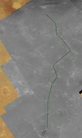
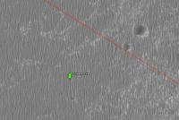
http://planetary.s3.amazonaws.com/gmars_ma...41_1775_RED.kml Follow the link above and it should load right in to your Google Mars features. I took a low crow's flight along the final 6km this morning. Below in green is what I think the final route will look like. Also an interesting feature along the way that appears to be a cluster of rocks, possibly Santa Maria ejecta, or large meteorite fragments. Note how the dune has evolved around the three (or more) objects. Object is at -2.199395°, -5.396676° -- roughly 3km down range from Santa Maria. EDIT: bad link replaced, wider context image added for three rocks.
Attached thumbnail(s)
-------------------- If Occam had heard my theory, things would be very different now.
|
|||
 |
 
|
|||
 |
|
Apr 7 2011, 08:43 PM
Post
#2
|
|
|
Solar System Cartographer Group: Members Posts: 10226 Joined: 5-April 05 From: Canada Member No.: 227 |
Interesting! I forgot about that. Looks like my feature shows up better on that - the last one of the set.
Phil -------------------- ... because the Solar System ain't gonna map itself.
Also to be found posting similar content on https://mastodon.social/@PhilStooke Maps for download (free PDF: https://upload.wikimedia.org/wikipedia/comm...Cartography.pdf NOTE: everything created by me which I post on UMSF is considered to be in the public domain (NOT CC, public domain) |
|
|
|
|
Apr 8 2011, 09:23 AM
Post
#3
|
|||
|
Junior Member Group: Members Posts: 59 Joined: 18-July 07 From: London, UK Member No.: 2873 |
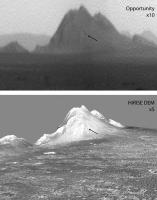
QUOTE (Phil Stooke @ Apr 7 2011, 09:43 PM)  Interesting! I forgot about that. Looks like my feature shows up better on that - the last one of the set. Phil Might be heading towards Distant Vistas here (please feel free to move), but good eyes Phil! There does seem to be a subdued and dark crater on those slopes. Getting a rough view alignment between my HiRISE DEM and your stretched pan shows a pretty good match, and where this dark thing is.
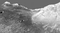
And looking a bit closer from another angle it is still there.
But there's a bit of driving to do before we get here... Pete |
||
|
|
|
||
 ElkGroveDan Post Conjunction: Santa Maria to Cape York Feb 8 2011, 03:35 PM
 mhoward Sol 2554 left Pancam Apr 2 2011, 04:50 PM nprev ...yeah, kinda sorta!
Kapton's just nas... Apr 2 2011, 05:30 PM Phil Stooke "it's left me an aged & bitter SOB... Apr 2 2011, 05:33 PM nprev You got me cold, Phil; kapton is the devil!
... Apr 2 2011, 05:35 PM Phil Stooke And I foolishly edited the last post to insert an ... Apr 2 2011, 05:42 PM
mhoward Sol 2554 left Pancam Apr 2 2011, 04:50 PM nprev ...yeah, kinda sorta!
Kapton's just nas... Apr 2 2011, 05:30 PM Phil Stooke "it's left me an aged & bitter SOB... Apr 2 2011, 05:33 PM nprev You got me cold, Phil; kapton is the devil!
... Apr 2 2011, 05:35 PM Phil Stooke And I foolishly edited the last post to insert an ... Apr 2 2011, 05:42 PM
 walfy The RAT could chew off the Kapton if it becomes a ... Apr 2 2011, 06:49 PM djellison QUOTE (walfy @ Apr 2 2011, 11:49 AM) The ... Apr 3 2011, 01:14 AM Stu Oh, I love this rock...
Apr 3 2011, 09:10 AM Tesheiner QUOTE (Stu @ Apr 3 2011, 11:10 AM) Oh, I ... Apr 3 2011, 09:30 PM jvandriel Looking back and around on Sol 2552 with
the L0 Na... Apr 3 2011, 09:40 AM Stu Some very interesting features up ahead - circular... Apr 3 2011, 10:47 AM fredk (Stu, I think that should read bottom to top.)
Th... Apr 3 2011, 02:33 PM Phil Stooke Right Fred - plus that pic shows why Santa Maria w... Apr 3 2011, 03:52 PM mhoward Looking back - sol 2552 Navcam
Sol 2554 Navcam
... Apr 3 2011, 04:15 PM nprev What's with the little wheel slews in the trac... Apr 3 2011, 06:12 PM fredk Check out this post. Apr 3 2011, 06:16 PM nprev Yeah, I saw that, Fred, but the puzzle pieces didn... Apr 3 2011, 06:51 PM eoincampbell Heavy, man! Apr 3 2011, 10:31 PM Stu We've seen something like that before...
Apr 3 2011, 11:31 PM nprev However, in sharp contrast, Big Rock requests that... Apr 4 2011, 12:29 AM Stu Large 3D view of the road ahead for Oppy... liking... Apr 4 2011, 04:28 PM Stu Slightly more realistic view of our big ugly crumb... Apr 5 2011, 10:49 AM jamescanvin QUOTE (Stu @ Apr 5 2011, 11:49 AM) what i... Apr 5 2011, 10:57 AM Stu Thanks, James. Apr 5 2011, 11:17 AM fredk On 2556 we were sitting on one of the slightly dar... Apr 5 2011, 03:13 PM Tesheiner I saw that too and made this polar view in an atte... Apr 5 2011, 03:49 PM Phil Stooke So... adding a bit of a stretch factor to Tesheine... Apr 5 2011, 04:36 PM fredk For my millennial post, let me say that I agree wi... Apr 5 2011, 05:03 PM Tesheiner Thanks a lot!
I logged-in just to post yet an... Apr 5 2011, 06:01 PM Phil Stooke Scott tweeted that the drive would be longer, stop... Apr 5 2011, 08:03 PM Tesheiner QUOTE (Phil Stooke @ Apr 5 2011, 10:03 PM... Apr 6 2011, 05:57 AM Astro0 Admin: A few posts on the Peugeot advert were move... Apr 5 2011, 10:39 PM jvandriel The Pancam L2 view on Sol 2556.
Jan van Driel
Apr 6 2011, 09:32 AM Phil Stooke ... and doing a 10x stretch of that image, we get ... Apr 6 2011, 02:28 PM Tesheiner Around 27500m. Apr 6 2011, 09:06 PM Stu Loving the depth of field here...
Apr 6 2011, 09:35 PM climber Mean per sol from October 12th to December 8th (be... Apr 7 2011, 01:32 PM Stu Beautiful horizon...
Apr 7 2011, 02:03 PM MahFL It's just like the approach to the Columbia Hi... Apr 7 2011, 02:39 PM Phil Stooke Here's a comparison of the view from Concepcio... Apr 7 2011, 03:23 PM Phil Stooke And closing in on Cape Tribulation, there's a ... Apr 7 2011, 04:59 PM Tesheiner Could it be a JPEG artifact? I can't see it on... Apr 7 2011, 06:53 PM Phil Stooke This link:
http://www.unmannedspaceflight.com/ind... Apr 7 2011, 07:08 PM ngunn I don't know if it helps with that crater, but... Apr 7 2011, 07:40 PM Tesheiner This is after yesterday's (sol 2560) drive; ba... Apr 8 2011, 08:02 AM Of counsel We traveled 145 meters on sol 2560? Impressive (i... Apr 8 2011, 06:16 PM Stu Back on the light, crumbly stuff...
...and a 3D... Apr 8 2011, 07:08 PM ElkGroveDan With sol 2560's drive, that's almost exact... Apr 9 2011, 12:15 AM PaulM QUOTE (ElkGroveDan @ Apr 9 2011, 12:15 AM... Apr 9 2011, 03:41 PM jvandriel The Pancam R2 view on Sol 2561.
Jan van Driel
Apr 9 2011, 11:42 AM Phil Stooke We're coming up out of the shallow depression ... Apr 9 2011, 02:02 PM Tesheiner QUOTE (Phil Stooke @ Apr 9 2011, 04:02 PM... Apr 9 2011, 08:08 PM BrianL You've got 150 years to get it done, Scotty.
... Apr 9 2011, 07:30 PM Stu Very nice view of the nearest hills...
Apr 9 2011, 09:58 PM eoincampbell Amazing Pace ! Apr 10 2011, 03:16 AM ronatu QUOTE (eoincampbell @ Apr 9 2011, 11:16 P... Apr 10 2011, 03:42 AM sgendreau Vrroooooooooooooom, straight down the run line. L... Apr 10 2011, 03:44 AM Stu 830m ahead is a "double crater" that loo... Apr 10 2011, 08:41 AM vikingmars QUOTE (Stu @ Apr 10 2011, 10:41 AM) 830m ... Apr 10 2011, 06:17 PM mhoward Responding to CosmicRocker's post in the map t... Apr 10 2011, 04:56 PM Phil Stooke "if there was anything interesting to see in ... Apr 10 2011, 07:09 PM climber I realize that the remaining distance is the same ... Apr 10 2011, 11:28 PM CosmicRocker QUOTE (mhoward @ Apr 10 2011, 11:56 AM) .... Apr 11 2011, 06:16 AM Stu I was mucking about with experimenting with stacki... Apr 11 2011, 10:24 PM Astro0 Nice
Love how the extra details in the "hil... Apr 11 2011, 11:34 PM jvandriel The Pancam L2 view on Sol 2563.
Jan van Driel
Apr 12 2011, 05:08 PM Phil Stooke Nice pan! And here's a match to a HiRISE ... Apr 12 2011, 05:34 PM Stu Just briefly going back to my image of the "h... Apr 12 2011, 06:17 PM jasedm Very nice juxtaposition Stu.
I remember camping i... Apr 12 2011, 07:17 PM Stu QUOTE (jasedm @ Apr 12 2011, 08:17 PM) do... Apr 12 2011, 07:24 PM AndyG Great choice of location, Stu.
Here's The Ull... Apr 12 2011, 07:23 PM john_s QUOTE (AndyG @ Apr 12 2011, 08:23 PM) Her... Apr 12 2011, 08:23 PM AndyG QUOTE (john_s @ Apr 12 2011, 09:23 PM) Th... Apr 12 2011, 09:19 PM djellison The horizon drop-off might be analogous though - M... Apr 12 2011, 08:38 PM Stu QUOTE (john_s @ Apr 12 2011, 09:23 PM) I... Apr 12 2011, 09:02 PM ElkGroveDan I want to know how many ulls you caught Stu. Apr 12 2011, 09:05 PM Stu "ulls"? Apr 12 2011, 09:19 PM ElkGroveDan QUOTE (Stu @ Apr 12 2011, 01:19 PM) ... Apr 12 2011, 09:37 PM KrisK What was the reason of going back here?
http://qt.... Apr 12 2011, 09:41 PM djellison QUOTE (KrisK @ Apr 12 2011, 02:41 PM) Wha... Apr 12 2011, 10:41 PM climber You mean U(lls) turn? Apr 12 2011, 11:32 PM MahFL Oh I did not realise that was Santa Maria.
It... Apr 13 2011, 01:01 PM mhoward Navcam images just came down of a big crack that O... Apr 13 2011, 04:47 PM walfy I always wondered what one of those fissures looke... Apr 13 2011, 06:35 PM Juramike I like it! Very cool to see how some of terra... Apr 13 2011, 07:37 PM Phil Stooke A circular reprojection of the very nice pan by mh... Apr 13 2011, 08:16 PM Tesheiner Here're some context images. The arrow points ... Apr 14 2011, 11:01 AM Marz Are these fractures associated with Endeavour, and... Apr 14 2011, 03:55 PM Tesheiner QUOTE (Marz @ Apr 14 2011, 05:55 PM) Are ... Apr 14 2011, 04:11 PM Oersted predates the bedrock? Apr 14 2011, 05:41 PM Phil Stooke Yes, predates the bedrock! That is, the Merid... Apr 14 2011, 05:54 PM Stu Rover driver Scott Maxwell was - as ever - kind en... Apr 14 2011, 07:15 PM Tesheiner QUOTE (Stu @ Apr 14 2011, 09:15 PM) ... w... Apr 14 2011, 08:12 PM
walfy The RAT could chew off the Kapton if it becomes a ... Apr 2 2011, 06:49 PM djellison QUOTE (walfy @ Apr 2 2011, 11:49 AM) The ... Apr 3 2011, 01:14 AM Stu Oh, I love this rock...
Apr 3 2011, 09:10 AM Tesheiner QUOTE (Stu @ Apr 3 2011, 11:10 AM) Oh, I ... Apr 3 2011, 09:30 PM jvandriel Looking back and around on Sol 2552 with
the L0 Na... Apr 3 2011, 09:40 AM Stu Some very interesting features up ahead - circular... Apr 3 2011, 10:47 AM fredk (Stu, I think that should read bottom to top.)
Th... Apr 3 2011, 02:33 PM Phil Stooke Right Fred - plus that pic shows why Santa Maria w... Apr 3 2011, 03:52 PM mhoward Looking back - sol 2552 Navcam
Sol 2554 Navcam
... Apr 3 2011, 04:15 PM nprev What's with the little wheel slews in the trac... Apr 3 2011, 06:12 PM fredk Check out this post. Apr 3 2011, 06:16 PM nprev Yeah, I saw that, Fred, but the puzzle pieces didn... Apr 3 2011, 06:51 PM eoincampbell Heavy, man! Apr 3 2011, 10:31 PM Stu We've seen something like that before...
Apr 3 2011, 11:31 PM nprev However, in sharp contrast, Big Rock requests that... Apr 4 2011, 12:29 AM Stu Large 3D view of the road ahead for Oppy... liking... Apr 4 2011, 04:28 PM Stu Slightly more realistic view of our big ugly crumb... Apr 5 2011, 10:49 AM jamescanvin QUOTE (Stu @ Apr 5 2011, 11:49 AM) what i... Apr 5 2011, 10:57 AM Stu Thanks, James. Apr 5 2011, 11:17 AM fredk On 2556 we were sitting on one of the slightly dar... Apr 5 2011, 03:13 PM Tesheiner I saw that too and made this polar view in an atte... Apr 5 2011, 03:49 PM Phil Stooke So... adding a bit of a stretch factor to Tesheine... Apr 5 2011, 04:36 PM fredk For my millennial post, let me say that I agree wi... Apr 5 2011, 05:03 PM Tesheiner Thanks a lot!
I logged-in just to post yet an... Apr 5 2011, 06:01 PM Phil Stooke Scott tweeted that the drive would be longer, stop... Apr 5 2011, 08:03 PM Tesheiner QUOTE (Phil Stooke @ Apr 5 2011, 10:03 PM... Apr 6 2011, 05:57 AM Astro0 Admin: A few posts on the Peugeot advert were move... Apr 5 2011, 10:39 PM jvandriel The Pancam L2 view on Sol 2556.
Jan van Driel
Apr 6 2011, 09:32 AM Phil Stooke ... and doing a 10x stretch of that image, we get ... Apr 6 2011, 02:28 PM Tesheiner Around 27500m. Apr 6 2011, 09:06 PM Stu Loving the depth of field here...
Apr 6 2011, 09:35 PM climber Mean per sol from October 12th to December 8th (be... Apr 7 2011, 01:32 PM Stu Beautiful horizon...
Apr 7 2011, 02:03 PM MahFL It's just like the approach to the Columbia Hi... Apr 7 2011, 02:39 PM Phil Stooke Here's a comparison of the view from Concepcio... Apr 7 2011, 03:23 PM Phil Stooke And closing in on Cape Tribulation, there's a ... Apr 7 2011, 04:59 PM Tesheiner Could it be a JPEG artifact? I can't see it on... Apr 7 2011, 06:53 PM Phil Stooke This link:
http://www.unmannedspaceflight.com/ind... Apr 7 2011, 07:08 PM ngunn I don't know if it helps with that crater, but... Apr 7 2011, 07:40 PM Tesheiner This is after yesterday's (sol 2560) drive; ba... Apr 8 2011, 08:02 AM Of counsel We traveled 145 meters on sol 2560? Impressive (i... Apr 8 2011, 06:16 PM Stu Back on the light, crumbly stuff...
...and a 3D... Apr 8 2011, 07:08 PM ElkGroveDan With sol 2560's drive, that's almost exact... Apr 9 2011, 12:15 AM PaulM QUOTE (ElkGroveDan @ Apr 9 2011, 12:15 AM... Apr 9 2011, 03:41 PM jvandriel The Pancam R2 view on Sol 2561.
Jan van Driel
Apr 9 2011, 11:42 AM Phil Stooke We're coming up out of the shallow depression ... Apr 9 2011, 02:02 PM Tesheiner QUOTE (Phil Stooke @ Apr 9 2011, 04:02 PM... Apr 9 2011, 08:08 PM BrianL You've got 150 years to get it done, Scotty.
... Apr 9 2011, 07:30 PM Stu Very nice view of the nearest hills...
Apr 9 2011, 09:58 PM eoincampbell Amazing Pace ! Apr 10 2011, 03:16 AM ronatu QUOTE (eoincampbell @ Apr 9 2011, 11:16 P... Apr 10 2011, 03:42 AM sgendreau Vrroooooooooooooom, straight down the run line. L... Apr 10 2011, 03:44 AM Stu 830m ahead is a "double crater" that loo... Apr 10 2011, 08:41 AM vikingmars QUOTE (Stu @ Apr 10 2011, 10:41 AM) 830m ... Apr 10 2011, 06:17 PM mhoward Responding to CosmicRocker's post in the map t... Apr 10 2011, 04:56 PM Phil Stooke "if there was anything interesting to see in ... Apr 10 2011, 07:09 PM climber I realize that the remaining distance is the same ... Apr 10 2011, 11:28 PM CosmicRocker QUOTE (mhoward @ Apr 10 2011, 11:56 AM) .... Apr 11 2011, 06:16 AM Stu I was mucking about with experimenting with stacki... Apr 11 2011, 10:24 PM Astro0 Nice
Love how the extra details in the "hil... Apr 11 2011, 11:34 PM jvandriel The Pancam L2 view on Sol 2563.
Jan van Driel
Apr 12 2011, 05:08 PM Phil Stooke Nice pan! And here's a match to a HiRISE ... Apr 12 2011, 05:34 PM Stu Just briefly going back to my image of the "h... Apr 12 2011, 06:17 PM jasedm Very nice juxtaposition Stu.
I remember camping i... Apr 12 2011, 07:17 PM Stu QUOTE (jasedm @ Apr 12 2011, 08:17 PM) do... Apr 12 2011, 07:24 PM AndyG Great choice of location, Stu.
Here's The Ull... Apr 12 2011, 07:23 PM john_s QUOTE (AndyG @ Apr 12 2011, 08:23 PM) Her... Apr 12 2011, 08:23 PM AndyG QUOTE (john_s @ Apr 12 2011, 09:23 PM) Th... Apr 12 2011, 09:19 PM djellison The horizon drop-off might be analogous though - M... Apr 12 2011, 08:38 PM Stu QUOTE (john_s @ Apr 12 2011, 09:23 PM) I... Apr 12 2011, 09:02 PM ElkGroveDan I want to know how many ulls you caught Stu. Apr 12 2011, 09:05 PM Stu "ulls"? Apr 12 2011, 09:19 PM ElkGroveDan QUOTE (Stu @ Apr 12 2011, 01:19 PM) ... Apr 12 2011, 09:37 PM KrisK What was the reason of going back here?
http://qt.... Apr 12 2011, 09:41 PM djellison QUOTE (KrisK @ Apr 12 2011, 02:41 PM) Wha... Apr 12 2011, 10:41 PM climber You mean U(lls) turn? Apr 12 2011, 11:32 PM MahFL Oh I did not realise that was Santa Maria.
It... Apr 13 2011, 01:01 PM mhoward Navcam images just came down of a big crack that O... Apr 13 2011, 04:47 PM walfy I always wondered what one of those fissures looke... Apr 13 2011, 06:35 PM Juramike I like it! Very cool to see how some of terra... Apr 13 2011, 07:37 PM Phil Stooke A circular reprojection of the very nice pan by mh... Apr 13 2011, 08:16 PM Tesheiner Here're some context images. The arrow points ... Apr 14 2011, 11:01 AM Marz Are these fractures associated with Endeavour, and... Apr 14 2011, 03:55 PM Tesheiner QUOTE (Marz @ Apr 14 2011, 05:55 PM) Are ... Apr 14 2011, 04:11 PM Oersted predates the bedrock? Apr 14 2011, 05:41 PM Phil Stooke Yes, predates the bedrock! That is, the Merid... Apr 14 2011, 05:54 PM Stu Rover driver Scott Maxwell was - as ever - kind en... Apr 14 2011, 07:15 PM Tesheiner QUOTE (Stu @ Apr 14 2011, 09:15 PM) ... w... Apr 14 2011, 08:12 PM |

|
Lo-Fi Version | Time is now: 21st September 2024 - 11:22 AM |
|
RULES AND GUIDELINES Please read the Forum Rules and Guidelines before posting. IMAGE COPYRIGHT |
OPINIONS AND MODERATION Opinions expressed on UnmannedSpaceflight.com are those of the individual posters and do not necessarily reflect the opinions of UnmannedSpaceflight.com or The Planetary Society. The all-volunteer UnmannedSpaceflight.com moderation team is wholly independent of The Planetary Society. The Planetary Society has no influence over decisions made by the UnmannedSpaceflight.com moderators. |
SUPPORT THE FORUM Unmannedspaceflight.com is funded by the Planetary Society. Please consider supporting our work and many other projects by donating to the Society or becoming a member. |
|