Post Conjunction: Santa Maria to Cape York, The Journey to 'Spirit Point' |

Post Conjunction: Santa Maria to Cape York, The Journey to 'Spirit Point' |
 Feb 8 2011, 03:35 PM Feb 8 2011, 03:35 PM
Post
#1
|
||||
 Senior Member  Group: Admin Posts: 4763 Joined: 15-March 05 From: Glendale, AZ Member No.: 197 |
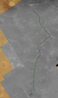
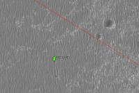
Starting a new topic to include Eduardo's Google overlay for the rest of the journey to Cape York:
http://planetary.s3.amazonaws.com/gmars_ma...41_1775_RED.kml Follow the link above and it should load right in to your Google Mars features. I took a low crow's flight along the final 6km this morning. Below in green is what I think the final route will look like. Also an interesting feature along the way that appears to be a cluster of rocks, possibly Santa Maria ejecta, or large meteorite fragments. Note how the dune has evolved around the three (or more) objects. Object is at -2.199395°, -5.396676° -- roughly 3km down range from Santa Maria. EDIT: bad link replaced, wider context image added for three rocks.
Attached thumbnail(s)
-------------------- If Occam had heard my theory, things would be very different now.
|
|||
 |
 
|
|||
 |
|
Apr 11 2011, 06:16 AM
Post
#2
|
|
 Senior Member Group: Members Posts: 2228 Joined: 1-December 04 From: Marble Falls, Texas, USA Member No.: 116 |
QUOTE (mhoward @ Apr 10 2011, 11:56 AM)  ... Yes; if there was anything interesting to see in the "dark terrain", it was too subtle at least for me to pick out. Oh well... onward! QUOTE (Phil Stooke @ Apr 10 2011, 02:09 PM) ... Not much obvious to see, but the surface was noticeably rougher. Elsewhere we had the extremely smooth surface with tiny ripples, as at Eagle crater. Here we had a generally rougher surface, and to me it looked as if a layer about 10 or 20 cm thick had been eroded away to reveal it. It would be interesting to map the distribution of the darker patches all around this area, to see it the distribution offers clues to its origin. ... It was pretty subtle, alright. Honestly, I was expecting it to be significantly more exciting. I'd have to agree with Phil regarding the surface appearing to be rougher. I was pretty much perplexed until it occurred to me that this dark terrain may simply be a large exposure of the Halfpipe formation. Some of us geologizers had previously started a thread devoted to the Halfpipe formation, where it was revealed that the name was informally applied to certain dark patches of coarse material overlying bedrock. I think one of the best exposures of the "formation" was observed on sols 707-717 as shown in the image I posted almost 5 years ago in the Halfpipe thread. See also, this comment. This is just another reminder about how much fun it has been to do armchair planetary geology through the rover's eyes. 
-------------------- ...Tom
I'm not a Space Fan, I'm a Space Exploration Enthusiast. |
|
|
|
 ElkGroveDan Post Conjunction: Santa Maria to Cape York Feb 8 2011, 03:35 PM
 mhoward Sol 2554 left Pancam Apr 2 2011, 04:50 PM nprev ...yeah, kinda sorta!
Kapton's just nas... Apr 2 2011, 05:30 PM Phil Stooke "it's left me an aged & bitter SOB... Apr 2 2011, 05:33 PM nprev You got me cold, Phil; kapton is the devil!
... Apr 2 2011, 05:35 PM Phil Stooke And I foolishly edited the last post to insert an ... Apr 2 2011, 05:42 PM
mhoward Sol 2554 left Pancam Apr 2 2011, 04:50 PM nprev ...yeah, kinda sorta!
Kapton's just nas... Apr 2 2011, 05:30 PM Phil Stooke "it's left me an aged & bitter SOB... Apr 2 2011, 05:33 PM nprev You got me cold, Phil; kapton is the devil!
... Apr 2 2011, 05:35 PM Phil Stooke And I foolishly edited the last post to insert an ... Apr 2 2011, 05:42 PM
 walfy The RAT could chew off the Kapton if it becomes a ... Apr 2 2011, 06:49 PM djellison QUOTE (walfy @ Apr 2 2011, 11:49 AM) The ... Apr 3 2011, 01:14 AM Stu Oh, I love this rock...
Apr 3 2011, 09:10 AM Tesheiner QUOTE (Stu @ Apr 3 2011, 11:10 AM) Oh, I ... Apr 3 2011, 09:30 PM jvandriel Looking back and around on Sol 2552 with
the L0 Na... Apr 3 2011, 09:40 AM Stu Some very interesting features up ahead - circular... Apr 3 2011, 10:47 AM fredk (Stu, I think that should read bottom to top.)
Th... Apr 3 2011, 02:33 PM Phil Stooke Right Fred - plus that pic shows why Santa Maria w... Apr 3 2011, 03:52 PM mhoward Looking back - sol 2552 Navcam
Sol 2554 Navcam
... Apr 3 2011, 04:15 PM nprev What's with the little wheel slews in the trac... Apr 3 2011, 06:12 PM fredk Check out this post. Apr 3 2011, 06:16 PM nprev Yeah, I saw that, Fred, but the puzzle pieces didn... Apr 3 2011, 06:51 PM eoincampbell Heavy, man! Apr 3 2011, 10:31 PM Stu We've seen something like that before...
Apr 3 2011, 11:31 PM nprev However, in sharp contrast, Big Rock requests that... Apr 4 2011, 12:29 AM Stu Large 3D view of the road ahead for Oppy... liking... Apr 4 2011, 04:28 PM Stu Slightly more realistic view of our big ugly crumb... Apr 5 2011, 10:49 AM jamescanvin QUOTE (Stu @ Apr 5 2011, 11:49 AM) what i... Apr 5 2011, 10:57 AM Stu Thanks, James. Apr 5 2011, 11:17 AM fredk On 2556 we were sitting on one of the slightly dar... Apr 5 2011, 03:13 PM Tesheiner I saw that too and made this polar view in an atte... Apr 5 2011, 03:49 PM Phil Stooke So... adding a bit of a stretch factor to Tesheine... Apr 5 2011, 04:36 PM fredk For my millennial post, let me say that I agree wi... Apr 5 2011, 05:03 PM Tesheiner Thanks a lot!
I logged-in just to post yet an... Apr 5 2011, 06:01 PM Phil Stooke Scott tweeted that the drive would be longer, stop... Apr 5 2011, 08:03 PM Tesheiner QUOTE (Phil Stooke @ Apr 5 2011, 10:03 PM... Apr 6 2011, 05:57 AM Astro0 Admin: A few posts on the Peugeot advert were move... Apr 5 2011, 10:39 PM jvandriel The Pancam L2 view on Sol 2556.
Jan van Driel
Apr 6 2011, 09:32 AM Phil Stooke ... and doing a 10x stretch of that image, we get ... Apr 6 2011, 02:28 PM Tesheiner Around 27500m. Apr 6 2011, 09:06 PM Stu Loving the depth of field here...
Apr 6 2011, 09:35 PM climber Mean per sol from October 12th to December 8th (be... Apr 7 2011, 01:32 PM Stu Beautiful horizon...
Apr 7 2011, 02:03 PM MahFL It's just like the approach to the Columbia Hi... Apr 7 2011, 02:39 PM Phil Stooke Here's a comparison of the view from Concepcio... Apr 7 2011, 03:23 PM Phil Stooke And closing in on Cape Tribulation, there's a ... Apr 7 2011, 04:59 PM Tesheiner Could it be a JPEG artifact? I can't see it on... Apr 7 2011, 06:53 PM Phil Stooke This link:
http://www.unmannedspaceflight.com/ind... Apr 7 2011, 07:08 PM ngunn I don't know if it helps with that crater, but... Apr 7 2011, 07:40 PM Phil Stooke Interesting! I forgot about that. Looks like... Apr 7 2011, 08:43 PM pgrindrod QUOTE (Phil Stooke @ Apr 7 2011, 09:43 PM... Apr 8 2011, 09:23 AM Tesheiner This is after yesterday's (sol 2560) drive; ba... Apr 8 2011, 08:02 AM Of counsel We traveled 145 meters on sol 2560? Impressive (i... Apr 8 2011, 06:16 PM Stu Back on the light, crumbly stuff...
...and a 3D... Apr 8 2011, 07:08 PM ElkGroveDan With sol 2560's drive, that's almost exact... Apr 9 2011, 12:15 AM PaulM QUOTE (ElkGroveDan @ Apr 9 2011, 12:15 AM... Apr 9 2011, 03:41 PM jvandriel The Pancam R2 view on Sol 2561.
Jan van Driel
Apr 9 2011, 11:42 AM Phil Stooke We're coming up out of the shallow depression ... Apr 9 2011, 02:02 PM Tesheiner QUOTE (Phil Stooke @ Apr 9 2011, 04:02 PM... Apr 9 2011, 08:08 PM BrianL You've got 150 years to get it done, Scotty.
... Apr 9 2011, 07:30 PM Stu Very nice view of the nearest hills...
Apr 9 2011, 09:58 PM eoincampbell Amazing Pace ! Apr 10 2011, 03:16 AM ronatu QUOTE (eoincampbell @ Apr 9 2011, 11:16 P... Apr 10 2011, 03:42 AM sgendreau Vrroooooooooooooom, straight down the run line. L... Apr 10 2011, 03:44 AM Stu 830m ahead is a "double crater" that loo... Apr 10 2011, 08:41 AM vikingmars QUOTE (Stu @ Apr 10 2011, 10:41 AM) 830m ... Apr 10 2011, 06:17 PM mhoward Responding to CosmicRocker's post in the map t... Apr 10 2011, 04:56 PM Phil Stooke "if there was anything interesting to see in ... Apr 10 2011, 07:09 PM climber I realize that the remaining distance is the same ... Apr 10 2011, 11:28 PM Stu I was mucking about with experimenting with stacki... Apr 11 2011, 10:24 PM Astro0 Nice
Love how the extra details in the "hil... Apr 11 2011, 11:34 PM jvandriel The Pancam L2 view on Sol 2563.
Jan van Driel
Apr 12 2011, 05:08 PM Phil Stooke Nice pan! And here's a match to a HiRISE ... Apr 12 2011, 05:34 PM Stu Just briefly going back to my image of the "h... Apr 12 2011, 06:17 PM jasedm Very nice juxtaposition Stu.
I remember camping i... Apr 12 2011, 07:17 PM Stu QUOTE (jasedm @ Apr 12 2011, 08:17 PM) do... Apr 12 2011, 07:24 PM AndyG Great choice of location, Stu.
Here's The Ull... Apr 12 2011, 07:23 PM john_s QUOTE (AndyG @ Apr 12 2011, 08:23 PM) Her... Apr 12 2011, 08:23 PM AndyG QUOTE (john_s @ Apr 12 2011, 09:23 PM) Th... Apr 12 2011, 09:19 PM djellison The horizon drop-off might be analogous though - M... Apr 12 2011, 08:38 PM Stu QUOTE (john_s @ Apr 12 2011, 09:23 PM) I... Apr 12 2011, 09:02 PM ElkGroveDan I want to know how many ulls you caught Stu. Apr 12 2011, 09:05 PM Stu "ulls"? Apr 12 2011, 09:19 PM ElkGroveDan QUOTE (Stu @ Apr 12 2011, 01:19 PM) ... Apr 12 2011, 09:37 PM KrisK What was the reason of going back here?
http://qt.... Apr 12 2011, 09:41 PM djellison QUOTE (KrisK @ Apr 12 2011, 02:41 PM) Wha... Apr 12 2011, 10:41 PM climber You mean U(lls) turn? Apr 12 2011, 11:32 PM MahFL Oh I did not realise that was Santa Maria.
It... Apr 13 2011, 01:01 PM mhoward Navcam images just came down of a big crack that O... Apr 13 2011, 04:47 PM walfy I always wondered what one of those fissures looke... Apr 13 2011, 06:35 PM Juramike I like it! Very cool to see how some of terra... Apr 13 2011, 07:37 PM Phil Stooke A circular reprojection of the very nice pan by mh... Apr 13 2011, 08:16 PM Tesheiner Here're some context images. The arrow points ... Apr 14 2011, 11:01 AM Marz Are these fractures associated with Endeavour, and... Apr 14 2011, 03:55 PM Tesheiner QUOTE (Marz @ Apr 14 2011, 05:55 PM) Are ... Apr 14 2011, 04:11 PM Oersted predates the bedrock? Apr 14 2011, 05:41 PM Phil Stooke Yes, predates the bedrock! That is, the Merid... Apr 14 2011, 05:54 PM Stu Rover driver Scott Maxwell was - as ever - kind en... Apr 14 2011, 07:15 PM Tesheiner QUOTE (Stu @ Apr 14 2011, 09:15 PM) ... w... Apr 14 2011, 08:12 PM
walfy The RAT could chew off the Kapton if it becomes a ... Apr 2 2011, 06:49 PM djellison QUOTE (walfy @ Apr 2 2011, 11:49 AM) The ... Apr 3 2011, 01:14 AM Stu Oh, I love this rock...
Apr 3 2011, 09:10 AM Tesheiner QUOTE (Stu @ Apr 3 2011, 11:10 AM) Oh, I ... Apr 3 2011, 09:30 PM jvandriel Looking back and around on Sol 2552 with
the L0 Na... Apr 3 2011, 09:40 AM Stu Some very interesting features up ahead - circular... Apr 3 2011, 10:47 AM fredk (Stu, I think that should read bottom to top.)
Th... Apr 3 2011, 02:33 PM Phil Stooke Right Fred - plus that pic shows why Santa Maria w... Apr 3 2011, 03:52 PM mhoward Looking back - sol 2552 Navcam
Sol 2554 Navcam
... Apr 3 2011, 04:15 PM nprev What's with the little wheel slews in the trac... Apr 3 2011, 06:12 PM fredk Check out this post. Apr 3 2011, 06:16 PM nprev Yeah, I saw that, Fred, but the puzzle pieces didn... Apr 3 2011, 06:51 PM eoincampbell Heavy, man! Apr 3 2011, 10:31 PM Stu We've seen something like that before...
Apr 3 2011, 11:31 PM nprev However, in sharp contrast, Big Rock requests that... Apr 4 2011, 12:29 AM Stu Large 3D view of the road ahead for Oppy... liking... Apr 4 2011, 04:28 PM Stu Slightly more realistic view of our big ugly crumb... Apr 5 2011, 10:49 AM jamescanvin QUOTE (Stu @ Apr 5 2011, 11:49 AM) what i... Apr 5 2011, 10:57 AM Stu Thanks, James. Apr 5 2011, 11:17 AM fredk On 2556 we were sitting on one of the slightly dar... Apr 5 2011, 03:13 PM Tesheiner I saw that too and made this polar view in an atte... Apr 5 2011, 03:49 PM Phil Stooke So... adding a bit of a stretch factor to Tesheine... Apr 5 2011, 04:36 PM fredk For my millennial post, let me say that I agree wi... Apr 5 2011, 05:03 PM Tesheiner Thanks a lot!
I logged-in just to post yet an... Apr 5 2011, 06:01 PM Phil Stooke Scott tweeted that the drive would be longer, stop... Apr 5 2011, 08:03 PM Tesheiner QUOTE (Phil Stooke @ Apr 5 2011, 10:03 PM... Apr 6 2011, 05:57 AM Astro0 Admin: A few posts on the Peugeot advert were move... Apr 5 2011, 10:39 PM jvandriel The Pancam L2 view on Sol 2556.
Jan van Driel
Apr 6 2011, 09:32 AM Phil Stooke ... and doing a 10x stretch of that image, we get ... Apr 6 2011, 02:28 PM Tesheiner Around 27500m. Apr 6 2011, 09:06 PM Stu Loving the depth of field here...
Apr 6 2011, 09:35 PM climber Mean per sol from October 12th to December 8th (be... Apr 7 2011, 01:32 PM Stu Beautiful horizon...
Apr 7 2011, 02:03 PM MahFL It's just like the approach to the Columbia Hi... Apr 7 2011, 02:39 PM Phil Stooke Here's a comparison of the view from Concepcio... Apr 7 2011, 03:23 PM Phil Stooke And closing in on Cape Tribulation, there's a ... Apr 7 2011, 04:59 PM Tesheiner Could it be a JPEG artifact? I can't see it on... Apr 7 2011, 06:53 PM Phil Stooke This link:
http://www.unmannedspaceflight.com/ind... Apr 7 2011, 07:08 PM ngunn I don't know if it helps with that crater, but... Apr 7 2011, 07:40 PM Phil Stooke Interesting! I forgot about that. Looks like... Apr 7 2011, 08:43 PM pgrindrod QUOTE (Phil Stooke @ Apr 7 2011, 09:43 PM... Apr 8 2011, 09:23 AM Tesheiner This is after yesterday's (sol 2560) drive; ba... Apr 8 2011, 08:02 AM Of counsel We traveled 145 meters on sol 2560? Impressive (i... Apr 8 2011, 06:16 PM Stu Back on the light, crumbly stuff...
...and a 3D... Apr 8 2011, 07:08 PM ElkGroveDan With sol 2560's drive, that's almost exact... Apr 9 2011, 12:15 AM PaulM QUOTE (ElkGroveDan @ Apr 9 2011, 12:15 AM... Apr 9 2011, 03:41 PM jvandriel The Pancam R2 view on Sol 2561.
Jan van Driel
Apr 9 2011, 11:42 AM Phil Stooke We're coming up out of the shallow depression ... Apr 9 2011, 02:02 PM Tesheiner QUOTE (Phil Stooke @ Apr 9 2011, 04:02 PM... Apr 9 2011, 08:08 PM BrianL You've got 150 years to get it done, Scotty.
... Apr 9 2011, 07:30 PM Stu Very nice view of the nearest hills...
Apr 9 2011, 09:58 PM eoincampbell Amazing Pace ! Apr 10 2011, 03:16 AM ronatu QUOTE (eoincampbell @ Apr 9 2011, 11:16 P... Apr 10 2011, 03:42 AM sgendreau Vrroooooooooooooom, straight down the run line. L... Apr 10 2011, 03:44 AM Stu 830m ahead is a "double crater" that loo... Apr 10 2011, 08:41 AM vikingmars QUOTE (Stu @ Apr 10 2011, 10:41 AM) 830m ... Apr 10 2011, 06:17 PM mhoward Responding to CosmicRocker's post in the map t... Apr 10 2011, 04:56 PM Phil Stooke "if there was anything interesting to see in ... Apr 10 2011, 07:09 PM climber I realize that the remaining distance is the same ... Apr 10 2011, 11:28 PM Stu I was mucking about with experimenting with stacki... Apr 11 2011, 10:24 PM Astro0 Nice
Love how the extra details in the "hil... Apr 11 2011, 11:34 PM jvandriel The Pancam L2 view on Sol 2563.
Jan van Driel
Apr 12 2011, 05:08 PM Phil Stooke Nice pan! And here's a match to a HiRISE ... Apr 12 2011, 05:34 PM Stu Just briefly going back to my image of the "h... Apr 12 2011, 06:17 PM jasedm Very nice juxtaposition Stu.
I remember camping i... Apr 12 2011, 07:17 PM Stu QUOTE (jasedm @ Apr 12 2011, 08:17 PM) do... Apr 12 2011, 07:24 PM AndyG Great choice of location, Stu.
Here's The Ull... Apr 12 2011, 07:23 PM john_s QUOTE (AndyG @ Apr 12 2011, 08:23 PM) Her... Apr 12 2011, 08:23 PM AndyG QUOTE (john_s @ Apr 12 2011, 09:23 PM) Th... Apr 12 2011, 09:19 PM djellison The horizon drop-off might be analogous though - M... Apr 12 2011, 08:38 PM Stu QUOTE (john_s @ Apr 12 2011, 09:23 PM) I... Apr 12 2011, 09:02 PM ElkGroveDan I want to know how many ulls you caught Stu. Apr 12 2011, 09:05 PM Stu "ulls"? Apr 12 2011, 09:19 PM ElkGroveDan QUOTE (Stu @ Apr 12 2011, 01:19 PM) ... Apr 12 2011, 09:37 PM KrisK What was the reason of going back here?
http://qt.... Apr 12 2011, 09:41 PM djellison QUOTE (KrisK @ Apr 12 2011, 02:41 PM) Wha... Apr 12 2011, 10:41 PM climber You mean U(lls) turn? Apr 12 2011, 11:32 PM MahFL Oh I did not realise that was Santa Maria.
It... Apr 13 2011, 01:01 PM mhoward Navcam images just came down of a big crack that O... Apr 13 2011, 04:47 PM walfy I always wondered what one of those fissures looke... Apr 13 2011, 06:35 PM Juramike I like it! Very cool to see how some of terra... Apr 13 2011, 07:37 PM Phil Stooke A circular reprojection of the very nice pan by mh... Apr 13 2011, 08:16 PM Tesheiner Here're some context images. The arrow points ... Apr 14 2011, 11:01 AM Marz Are these fractures associated with Endeavour, and... Apr 14 2011, 03:55 PM Tesheiner QUOTE (Marz @ Apr 14 2011, 05:55 PM) Are ... Apr 14 2011, 04:11 PM Oersted predates the bedrock? Apr 14 2011, 05:41 PM Phil Stooke Yes, predates the bedrock! That is, the Merid... Apr 14 2011, 05:54 PM Stu Rover driver Scott Maxwell was - as ever - kind en... Apr 14 2011, 07:15 PM Tesheiner QUOTE (Stu @ Apr 14 2011, 09:15 PM) ... w... Apr 14 2011, 08:12 PM |

|
Lo-Fi Version | Time is now: 20th June 2024 - 10:07 AM |
|
RULES AND GUIDELINES Please read the Forum Rules and Guidelines before posting. IMAGE COPYRIGHT |
OPINIONS AND MODERATION Opinions expressed on UnmannedSpaceflight.com are those of the individual posters and do not necessarily reflect the opinions of UnmannedSpaceflight.com or The Planetary Society. The all-volunteer UnmannedSpaceflight.com moderation team is wholly independent of The Planetary Society. The Planetary Society has no influence over decisions made by the UnmannedSpaceflight.com moderators. |
SUPPORT THE FORUM Unmannedspaceflight.com is funded by the Planetary Society. Please consider supporting our work and many other projects by donating to the Society or becoming a member. |
|