Opportunity Route Map |

Opportunity Route Map |
 Feb 11 2005, 08:11 AM Feb 11 2005, 08:11 AM
Post
#1
|
||
 The Insider  Group: Members Posts: 669 Joined: 3-May 04 Member No.: 73 |
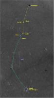
Here is an updated map of the road to Vostok.
Attached thumbnail(s)
|
|
 |
 
|
|
 |
|
Aug 17 2005, 09:36 AM
Post
#2
|
|
|
Senior Member Group: Members Posts: 3008 Joined: 30-October 04 Member No.: 105 |
The earlier discussions noted that Erebus and Terra Nova were on a slight topographic rise and once we got past Terra Nova we would be at a location initially named "Hell Of A View". I'm looking forward to that.
I think that Oppy is getting ready to move over to the east onto the Erebus Highway and head southward rather than cross the dunefield directly south of her. Also it will give better science to look at the bedrock than sand, sand, sand. --Bill -------------------- |
|
|
|
 Pando Opportunity Route Map Feb 11 2005, 08:11 AM
 TheChemist I would not worry, flight director updates have be... Aug 6 2005, 10:04 PM Bill Harris QUOTE Now, if distance from Erebus rim is really 1... Aug 6 2005, 10:46 PM Tesheiner > Suggestions?
Yes.
Phil's picture --- the... Aug 8 2005, 07:57 AM Tesheiner Mmmm,
I'm not so confortable with my previous... Aug 8 2005, 10:54 AM TheChemist I downloaded the raw R1500822 image from the MSSS ... Aug 8 2005, 12:06 PM djellison The raw (not projected) images show the huge verti... Aug 8 2005, 12:43 PM Tesheiner Yes, but which is the resolution of that image?
T... Aug 8 2005, 02:13 PM
TheChemist I would not worry, flight director updates have be... Aug 6 2005, 10:04 PM Bill Harris QUOTE Now, if distance from Erebus rim is really 1... Aug 6 2005, 10:46 PM Tesheiner > Suggestions?
Yes.
Phil's picture --- the... Aug 8 2005, 07:57 AM Tesheiner Mmmm,
I'm not so confortable with my previous... Aug 8 2005, 10:54 AM TheChemist I downloaded the raw R1500822 image from the MSSS ... Aug 8 2005, 12:06 PM djellison The raw (not projected) images show the huge verti... Aug 8 2005, 12:43 PM Tesheiner Yes, but which is the resolution of that image?
T... Aug 8 2005, 02:13 PM
 RNeuhaus QUOTE (Tesheiner @ Aug 8 2005, 09:13 AM)The d... Aug 9 2005, 10:59 PM Tesheiner QUOTE (RNeuhaus @ Aug 10 2005, 12:59 AM)Hello... Aug 10 2005, 07:09 AM djellison The odd thing is - the 0.7something m/pixel is act... Aug 8 2005, 02:55 PM dilo Thanks to all for great contribution!
Now I... Aug 9 2005, 08:18 PM TheChemist I told you the flight director was messing with us... Aug 9 2005, 09:42 PM CosmicRocker This apparently is the "Ice Cream Cone?... Aug 10 2005, 05:26 AM RNeuhaus QUOTE (CosmicRocker @ Aug 10 2005, 12:26 AM)T... Aug 10 2005, 02:20 PM Tesheiner I'm still amazed about how easy is to pick tho... Aug 11 2005, 11:21 AM abalone QUOTE (Tesheiner @ Aug 11 2005, 10:21 PM)I... Aug 11 2005, 11:49 AM paxdan QUOTE (Tesheiner @ Aug 11 2005, 12:21 PM)I... Aug 12 2005, 10:00 AM paxdan Aaaaaarrgggggggg* powers of ten someone please.
W... Aug 12 2005, 10:26 AM elakdawalla QUOTE (paxdan @ Aug 12 2005, 03:26 AM)Aaaaaar... Aug 12 2005, 01:59 PM dilo Here the updated vertical projections mosaic:
Pa... Aug 12 2005, 09:34 PM paxdan Cheers for the maps Dilo. It's great to know o... Aug 12 2005, 11:03 PM dilo This is an example of what can be done MGS+rout... Aug 13 2005, 06:15 AM ElkGroveDan Great work Dilo.
I'm starting to get the feel... Aug 13 2005, 04:51 PM RNeuhaus QUOTE (dilo @ Aug 13 2005, 01:15 AM)This is a... Aug 15 2005, 03:16 PM babakm First thing I thought after seeing dilo's pict... Aug 15 2005, 05:44 PM ElkGroveDan QUOTE (babakm @ Aug 15 2005, 05:44 PM)Some of... Aug 15 2005, 06:36 PM babakm Excuse the hatchet job, but I'm referring to t... Aug 15 2005, 08:46 PM dilo Really a good catch, babakm!
I made a Phil-O v... Aug 16 2005, 11:26 PM Tesheiner QUOTE (dilo @ Aug 17 2005, 01:26 AM)Another i... Aug 17 2005, 06:34 AM ilbasso Reminds me of comedian Steven Wright: "I hav... Aug 12 2005, 01:37 PM deglr6328 Ha! look at the image on the cover of Science ... Aug 12 2005, 04:59 PM Chmee QUOTE (deglr6328 @ Aug 12 2005, 12:59 PM)Ha... Aug 12 2005, 06:37 PM Bob Shaw QUOTE (Chmee @ Aug 12 2005, 07:37 PM)What is ... Aug 12 2005, 08:26 PM Tman Dilo, it seems you approach the (PovRay) master mo... Aug 13 2005, 09:21 AM Decepticon Dilo you have just made my mouth drop! That is... Aug 13 2005, 12:39 PM lyford DILO - Sweet fancy moses - that's beautiful... Aug 13 2005, 05:00 PM dilo Tman, I'm definitvely NOT Erwann!
I foll... Aug 13 2005, 10:09 PM Myran Thank you dilo for the great and informing image, ... Aug 13 2005, 08:58 PM dot.dk dilo, that thing is just a beauty!! Best r... Aug 13 2005, 10:55 PM dilo Thanks to dot.dk and all people appreciating this ... Aug 13 2005, 11:19 PM glennwsmith Dilo, let me add my voice to the chorus -- this is... Aug 14 2005, 01:17 AM Decepticon JPL should see this!! And learn. Aug 14 2005, 03:38 AM Phil Stooke Just another voice added to the chorus of praise f... Aug 14 2005, 06:15 AM Reckless Dilo's work get better and better.
Roy F Aug 14 2005, 06:47 AM jvandriel Dilo,
in the lower right corner of the Combo 2 ma... Aug 14 2005, 02:00 PM dilo QUOTE (jvandriel @ Aug 14 2005, 02:00 PM)Dilo... Aug 15 2005, 06:44 AM CosmicRocker I believe the rover drivers and route planners use... Aug 14 2005, 05:10 PM Bob Shaw QUOTE (CosmicRocker @ Aug 14 2005, 06:10 PM)I... Aug 14 2005, 06:17 PM mhoward QUOTE (Bob Shaw @ Aug 14 2005, 06:17 PM)Speak... Aug 14 2005, 09:27 PM RedSky QUOTE (mhoward @ Aug 14 2005, 04:27 PM)Re: La... Aug 14 2005, 09:44 PM Bob Shaw QUOTE (mhoward @ Aug 14 2005, 10:27 PM)MMB do... Aug 14 2005, 10:08 PM RedSky New (Aug 14) update from Steve at the Athena site:... Aug 14 2005, 08:59 PM Marslauncher has anyone made a map as to how far we have driven... Aug 19 2005, 08:27 PM dilo QUOTE (Marslauncher @ Aug 19 2005, 08:27 PM)h... Aug 19 2005, 09:30 PM dilo Hope people will enjoy this divertissment: a new r... Aug 20 2005, 02:13 AM Cugel spacedaily
An Oppy update I have not yet seen any... Aug 19 2005, 09:03 PM remcook very fancy
you guys keep improving yourselves. ... Aug 20 2005, 10:22 AM ggoorden Has anyone an idea what this new picture on the Ex... Aug 20 2005, 10:44 AM Bob Shaw QUOTE (ggoorden @ Aug 20 2005, 11:44 AM)Has a... Aug 20 2005, 10:47 AM jvandriel A panoramic view of the Rat surface.
Taken with t... Aug 21 2005, 11:37 AM jvandriel A panoramic view of the same area before ratting.
... Aug 21 2005, 02:42 PM Phil Stooke Here's that view looking back towards Enduranc... Aug 21 2005, 04:32 PM dilo Impressive, Phil. I think you could be right on th... Aug 21 2005, 09:23 PM SigurRosFan Here's my updated traverse map.
http://xs43.x... Aug 24 2005, 12:28 PM dilo Me too ...
Edit: (corrected some imperfections) Aug 25 2005, 12:52 AM SigurRosFan And that's my updated traverse map (Sol 446 to... Aug 25 2005, 05:53 PM Sunspot Opportunity doesn't seem to be making much pro... Aug 25 2005, 06:05 PM antoniseb QUOTE (Sunspot @ Aug 25 2005, 01:05 PM)Opport... Aug 25 2005, 07:13 PM dilo OK, is done (hard to play with so many arguments..... Aug 25 2005, 08:58 PM Pando QUOTE (Sunspot @ Aug 25 2005, 11:05 AM)Opport... Aug 27 2005, 12:49 AM Sunspot QUOTE (Pando @ Aug 27 2005, 01:49 AM)yeah. Th... Aug 27 2005, 01:10 AM CosmicRocker dilo, it's been said many time before, but you... Aug 26 2005, 06:12 AM dilo QUOTE (CosmicRocker @ Aug 26 2005, 06:12 AM)d... Aug 26 2005, 06:24 AM Tesheiner QUOTE (CosmicRocker @ Aug 26 2005, 08:12 AM)I... Aug 26 2005, 07:15 AM babakm Dilo,
Any possibility of draping these over MOLA ... Aug 26 2005, 02:09 PM CosmicRocker QUOTE (Tesheiner @ Aug 26 2005, 01:15 AM)They... Aug 28 2005, 05:55 AM stevo Dilo, that is a great image. After all the excite... Aug 26 2005, 05:15 PM antoniseb Now THAT shows me where we are! Fantastic. I k... Aug 26 2005, 05:47 PM CosmicRocker If it truly is only a software issue, it should no... Aug 27 2005, 04:42 AM mike I would think Spirit would be having all the probl... Aug 27 2005, 05:25 AM general From
http://planetary.org/news/2005/mer-update_082... Aug 27 2005, 08:19 AM gregp1962 We've been 150 meters from Erebus for weeks no... Aug 27 2005, 05:58 PM Sunspot Imagine if Opportunity had not got stuck in Purgat... Aug 27 2005, 06:06 PM tty Now here's an interesting picture
Notice th... Aug 27 2005, 07:11 PM glennwsmith tty -- that IS some interesting strata. Don't... Aug 28 2005, 01:04 AM mike I thought the outcropping that Opportunity first s... Aug 28 2005, 02:32 AM CosmicRocker Actually, the geometry of those larger fractures i... Aug 28 2005, 05:21 AM dvandorn QUOTE (CosmicRocker @ Aug 28 2005, 12:21 AM).... Aug 28 2005, 12:12 PM tty QUOTE (dvandorn @ Aug 28 2005, 02:12 PM)These... Aug 28 2005, 05:55 PM CosmicRocker QUOTE (dvandorn @ Aug 28 2005, 06:12 AM)...
W... Aug 28 2005, 06:00 PM Decepticon Times like this I wish we had the ability to dig o... Aug 28 2005, 01:18 PM avkillick Are there any indications that the current glitch ... Aug 28 2005, 03:24 PM Sunspot QUOTE (avkillick @ Aug 28 2005, 04:24 PM)Are ... Aug 28 2005, 09:35 PM SFJCody The marswatch site shows no planned images for 567... Aug 28 2005, 09:44 PM Sunspot QUOTE (SFJCody @ Aug 28 2005, 10:44 PM)The ma... Aug 28 2005, 10:18 PM
RNeuhaus QUOTE (Tesheiner @ Aug 8 2005, 09:13 AM)The d... Aug 9 2005, 10:59 PM Tesheiner QUOTE (RNeuhaus @ Aug 10 2005, 12:59 AM)Hello... Aug 10 2005, 07:09 AM djellison The odd thing is - the 0.7something m/pixel is act... Aug 8 2005, 02:55 PM dilo Thanks to all for great contribution!
Now I... Aug 9 2005, 08:18 PM TheChemist I told you the flight director was messing with us... Aug 9 2005, 09:42 PM CosmicRocker This apparently is the "Ice Cream Cone?... Aug 10 2005, 05:26 AM RNeuhaus QUOTE (CosmicRocker @ Aug 10 2005, 12:26 AM)T... Aug 10 2005, 02:20 PM Tesheiner I'm still amazed about how easy is to pick tho... Aug 11 2005, 11:21 AM abalone QUOTE (Tesheiner @ Aug 11 2005, 10:21 PM)I... Aug 11 2005, 11:49 AM paxdan QUOTE (Tesheiner @ Aug 11 2005, 12:21 PM)I... Aug 12 2005, 10:00 AM paxdan Aaaaaarrgggggggg* powers of ten someone please.
W... Aug 12 2005, 10:26 AM elakdawalla QUOTE (paxdan @ Aug 12 2005, 03:26 AM)Aaaaaar... Aug 12 2005, 01:59 PM dilo Here the updated vertical projections mosaic:
Pa... Aug 12 2005, 09:34 PM paxdan Cheers for the maps Dilo. It's great to know o... Aug 12 2005, 11:03 PM dilo This is an example of what can be done MGS+rout... Aug 13 2005, 06:15 AM ElkGroveDan Great work Dilo.
I'm starting to get the feel... Aug 13 2005, 04:51 PM RNeuhaus QUOTE (dilo @ Aug 13 2005, 01:15 AM)This is a... Aug 15 2005, 03:16 PM babakm First thing I thought after seeing dilo's pict... Aug 15 2005, 05:44 PM ElkGroveDan QUOTE (babakm @ Aug 15 2005, 05:44 PM)Some of... Aug 15 2005, 06:36 PM babakm Excuse the hatchet job, but I'm referring to t... Aug 15 2005, 08:46 PM dilo Really a good catch, babakm!
I made a Phil-O v... Aug 16 2005, 11:26 PM Tesheiner QUOTE (dilo @ Aug 17 2005, 01:26 AM)Another i... Aug 17 2005, 06:34 AM ilbasso Reminds me of comedian Steven Wright: "I hav... Aug 12 2005, 01:37 PM deglr6328 Ha! look at the image on the cover of Science ... Aug 12 2005, 04:59 PM Chmee QUOTE (deglr6328 @ Aug 12 2005, 12:59 PM)Ha... Aug 12 2005, 06:37 PM Bob Shaw QUOTE (Chmee @ Aug 12 2005, 07:37 PM)What is ... Aug 12 2005, 08:26 PM Tman Dilo, it seems you approach the (PovRay) master mo... Aug 13 2005, 09:21 AM Decepticon Dilo you have just made my mouth drop! That is... Aug 13 2005, 12:39 PM lyford DILO - Sweet fancy moses - that's beautiful... Aug 13 2005, 05:00 PM dilo Tman, I'm definitvely NOT Erwann!
I foll... Aug 13 2005, 10:09 PM Myran Thank you dilo for the great and informing image, ... Aug 13 2005, 08:58 PM dot.dk dilo, that thing is just a beauty!! Best r... Aug 13 2005, 10:55 PM dilo Thanks to dot.dk and all people appreciating this ... Aug 13 2005, 11:19 PM glennwsmith Dilo, let me add my voice to the chorus -- this is... Aug 14 2005, 01:17 AM Decepticon JPL should see this!! And learn. Aug 14 2005, 03:38 AM Phil Stooke Just another voice added to the chorus of praise f... Aug 14 2005, 06:15 AM Reckless Dilo's work get better and better.
Roy F Aug 14 2005, 06:47 AM jvandriel Dilo,
in the lower right corner of the Combo 2 ma... Aug 14 2005, 02:00 PM dilo QUOTE (jvandriel @ Aug 14 2005, 02:00 PM)Dilo... Aug 15 2005, 06:44 AM CosmicRocker I believe the rover drivers and route planners use... Aug 14 2005, 05:10 PM Bob Shaw QUOTE (CosmicRocker @ Aug 14 2005, 06:10 PM)I... Aug 14 2005, 06:17 PM mhoward QUOTE (Bob Shaw @ Aug 14 2005, 06:17 PM)Speak... Aug 14 2005, 09:27 PM RedSky QUOTE (mhoward @ Aug 14 2005, 04:27 PM)Re: La... Aug 14 2005, 09:44 PM Bob Shaw QUOTE (mhoward @ Aug 14 2005, 10:27 PM)MMB do... Aug 14 2005, 10:08 PM RedSky New (Aug 14) update from Steve at the Athena site:... Aug 14 2005, 08:59 PM Marslauncher has anyone made a map as to how far we have driven... Aug 19 2005, 08:27 PM dilo QUOTE (Marslauncher @ Aug 19 2005, 08:27 PM)h... Aug 19 2005, 09:30 PM dilo Hope people will enjoy this divertissment: a new r... Aug 20 2005, 02:13 AM Cugel spacedaily
An Oppy update I have not yet seen any... Aug 19 2005, 09:03 PM remcook very fancy
you guys keep improving yourselves. ... Aug 20 2005, 10:22 AM ggoorden Has anyone an idea what this new picture on the Ex... Aug 20 2005, 10:44 AM Bob Shaw QUOTE (ggoorden @ Aug 20 2005, 11:44 AM)Has a... Aug 20 2005, 10:47 AM jvandriel A panoramic view of the Rat surface.
Taken with t... Aug 21 2005, 11:37 AM jvandriel A panoramic view of the same area before ratting.
... Aug 21 2005, 02:42 PM Phil Stooke Here's that view looking back towards Enduranc... Aug 21 2005, 04:32 PM dilo Impressive, Phil. I think you could be right on th... Aug 21 2005, 09:23 PM SigurRosFan Here's my updated traverse map.
http://xs43.x... Aug 24 2005, 12:28 PM dilo Me too ...
Edit: (corrected some imperfections) Aug 25 2005, 12:52 AM SigurRosFan And that's my updated traverse map (Sol 446 to... Aug 25 2005, 05:53 PM Sunspot Opportunity doesn't seem to be making much pro... Aug 25 2005, 06:05 PM antoniseb QUOTE (Sunspot @ Aug 25 2005, 01:05 PM)Opport... Aug 25 2005, 07:13 PM dilo OK, is done (hard to play with so many arguments..... Aug 25 2005, 08:58 PM Pando QUOTE (Sunspot @ Aug 25 2005, 11:05 AM)Opport... Aug 27 2005, 12:49 AM Sunspot QUOTE (Pando @ Aug 27 2005, 01:49 AM)yeah. Th... Aug 27 2005, 01:10 AM CosmicRocker dilo, it's been said many time before, but you... Aug 26 2005, 06:12 AM dilo QUOTE (CosmicRocker @ Aug 26 2005, 06:12 AM)d... Aug 26 2005, 06:24 AM Tesheiner QUOTE (CosmicRocker @ Aug 26 2005, 08:12 AM)I... Aug 26 2005, 07:15 AM babakm Dilo,
Any possibility of draping these over MOLA ... Aug 26 2005, 02:09 PM CosmicRocker QUOTE (Tesheiner @ Aug 26 2005, 01:15 AM)They... Aug 28 2005, 05:55 AM stevo Dilo, that is a great image. After all the excite... Aug 26 2005, 05:15 PM antoniseb Now THAT shows me where we are! Fantastic. I k... Aug 26 2005, 05:47 PM CosmicRocker If it truly is only a software issue, it should no... Aug 27 2005, 04:42 AM mike I would think Spirit would be having all the probl... Aug 27 2005, 05:25 AM general From
http://planetary.org/news/2005/mer-update_082... Aug 27 2005, 08:19 AM gregp1962 We've been 150 meters from Erebus for weeks no... Aug 27 2005, 05:58 PM Sunspot Imagine if Opportunity had not got stuck in Purgat... Aug 27 2005, 06:06 PM tty Now here's an interesting picture
Notice th... Aug 27 2005, 07:11 PM glennwsmith tty -- that IS some interesting strata. Don't... Aug 28 2005, 01:04 AM mike I thought the outcropping that Opportunity first s... Aug 28 2005, 02:32 AM CosmicRocker Actually, the geometry of those larger fractures i... Aug 28 2005, 05:21 AM dvandorn QUOTE (CosmicRocker @ Aug 28 2005, 12:21 AM).... Aug 28 2005, 12:12 PM tty QUOTE (dvandorn @ Aug 28 2005, 02:12 PM)These... Aug 28 2005, 05:55 PM CosmicRocker QUOTE (dvandorn @ Aug 28 2005, 06:12 AM)...
W... Aug 28 2005, 06:00 PM Decepticon Times like this I wish we had the ability to dig o... Aug 28 2005, 01:18 PM avkillick Are there any indications that the current glitch ... Aug 28 2005, 03:24 PM Sunspot QUOTE (avkillick @ Aug 28 2005, 04:24 PM)Are ... Aug 28 2005, 09:35 PM SFJCody The marswatch site shows no planned images for 567... Aug 28 2005, 09:44 PM Sunspot QUOTE (SFJCody @ Aug 28 2005, 10:44 PM)The ma... Aug 28 2005, 10:18 PM |

|
Lo-Fi Version | Time is now: 22nd September 2024 - 02:52 PM |
|
RULES AND GUIDELINES Please read the Forum Rules and Guidelines before posting. IMAGE COPYRIGHT |
OPINIONS AND MODERATION Opinions expressed on UnmannedSpaceflight.com are those of the individual posters and do not necessarily reflect the opinions of UnmannedSpaceflight.com or The Planetary Society. The all-volunteer UnmannedSpaceflight.com moderation team is wholly independent of The Planetary Society. The Planetary Society has no influence over decisions made by the UnmannedSpaceflight.com moderators. |
SUPPORT THE FORUM Unmannedspaceflight.com is funded by the Planetary Society. Please consider supporting our work and many other projects by donating to the Society or becoming a member. |
|