Post Conjunction: Santa Maria to Cape York, The Journey to 'Spirit Point' |

Post Conjunction: Santa Maria to Cape York, The Journey to 'Spirit Point' |
 Feb 8 2011, 03:35 PM Feb 8 2011, 03:35 PM
Post
#201
|
||||
 Senior Member  Group: Admin Posts: 4763 Joined: 15-March 05 From: Glendale, AZ Member No.: 197 |
Starting a new topic to include Eduardo's Google overlay for the rest of the journey to Cape York:
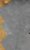
http://planetary.s3.amazonaws.com/gmars_ma...41_1775_RED.kml Follow the link above and it should load right in to your Google Mars features. I took a low crow's flight along the final 6km this morning. Below in green is what I think the final route will look like. Also an interesting feature along the way that appears to be a cluster of rocks, possibly Santa Maria ejecta, or large meteorite fragments. Note how the dune has evolved around the three (or more) objects. Object is at -2.199395°, -5.396676° -- roughly 3km down range from Santa Maria. EDIT: bad link replaced, wider context image added for three rocks.
Attached thumbnail(s)
-------------------- If Occam had heard my theory, things would be very different now.
|
|||
 |
 
|
|||
 |
|
May 1 2011, 12:56 PM
Post
#202
|
|
 The Poet Dude Group: Moderator Posts: 5551 Joined: 15-March 04 From: Kendal, Cumbria, UK Member No.: 60 |
This was very interesting, I thought...
The course charted will take Opportunity up to Endeavour's Cape York by way of Botany Bay, Arvidson confirmed. "Botany Bay through CRISM data shows hydrated sulfates and it's an easier approach to the southern side of Cape York where the phyllosilicates are exposed." Sooooo, looks like Oppy will actually drive past Cape York then double back and roll up onto it from the south. They really want a look at that rubble-surrounded crater, don't they? Can't wait to see those pics, as at least one of the blocks is bigger than Oppy herself... New Cape York pic up on: http://roadtoendeavour.wordpress.com/2011/...te-to-cape-york -------------------- |
|
|
|
|
May 1 2011, 06:01 PM
Post
#203
|
|
 Senior Member Group: Members Posts: 4247 Joined: 17-January 05 Member No.: 152 |
QUOTE (Stu @ May 1 2011, 01:56 PM)  "Botany Bay through CRISM data shows hydrated sulfates and it's an easier approach to the southern side of Cape York where the phyllosilicates are exposed." I'd just add one more point. I interpreted that quote differently. I read it "...it's an easier approach from the south end of Cape York to the region south of Cape York where the phyllosilicates are exposed." Ie, from the south end of CY they will be able to easily head south across Botany Bay towards Tribulation, where they know there are phyllosilicates. I don't think they're planning on phyllosilicates at CY, but any they do spot would be investigated, I'm sure. |
|
|
|
 ElkGroveDan Post Conjunction: Santa Maria to Cape York Feb 8 2011, 03:35 PM
 nprev That interview just plain rocked. I don't real... Apr 15 2011, 01:13 AM eoincampbell Loved reading that interview Stu - like getting a ... Apr 15 2011, 05:02 AM CosmicRocker QUOTE (Stu @ Apr 14 2011, 02:15 PM) ... w... Apr 15 2011, 06:48 AM jvandriel The Navcam R0 view on Sol 2563.
Jan van Driel
Apr 15 2011, 09:58 AM Phil Stooke Polar version of jvandriel's latest panorama.
... Apr 15 2011, 11:46 AM brellis Nice Jan van Pan <-- couldn't resist, afte... Apr 15 2011, 03:49 PM Stu Don't know about height, but as far as a direc... Apr 15 2011, 05:40 PM
nprev That interview just plain rocked. I don't real... Apr 15 2011, 01:13 AM eoincampbell Loved reading that interview Stu - like getting a ... Apr 15 2011, 05:02 AM CosmicRocker QUOTE (Stu @ Apr 14 2011, 02:15 PM) ... w... Apr 15 2011, 06:48 AM jvandriel The Navcam R0 view on Sol 2563.
Jan van Driel
Apr 15 2011, 09:58 AM Phil Stooke Polar version of jvandriel's latest panorama.
... Apr 15 2011, 11:46 AM brellis Nice Jan van Pan <-- couldn't resist, afte... Apr 15 2011, 03:49 PM Stu Don't know about height, but as far as a direc... Apr 15 2011, 05:40 PM
 PaulM I do not think that Scott was talking about Cape Y... Apr 15 2011, 07:00 PM Phil Stooke We now have better CRISM data than that paper used... Apr 15 2011, 08:12 PM Stu Hmmm. Interesting how our view of Tribulation etc ... Apr 15 2011, 10:19 PM Stu If Oppy does go climbing in those hills to the sou... Apr 16 2011, 11:38 AM Stu Latest view of the western hills...
Apr 17 2011, 10:11 AM Tesheiner We can almost touch them! Apr 17 2011, 10:19 AM Stu QUOTE (Tesheiner @ Apr 17 2011, 11:19 AM)... Apr 17 2011, 10:37 AM jvandriel A special Pan for Brellis
The pancam view on ... Apr 17 2011, 03:23 PM ngunn The shortish bright line in the middle distance - ... Apr 17 2011, 06:31 PM Tesheiner That crater is still too far away to be visible on... Apr 17 2011, 11:09 PM Stu That crater's a good 740m ahead yet, Nigel.
Apr 17 2011, 11:22 PM Phil Stooke Here's a match to the local topography. That ... Apr 17 2011, 11:39 PM Tesheiner Definitely Phil-o-vision is the right tool for thi... Apr 18 2011, 10:06 AM ngunn Thank goodness not all craters are hiding in hollo... Apr 18 2011, 01:12 PM Stu Well spotted Nigel! Apr 18 2011, 01:42 PM Sunspot Very quiet in here lately. Apr 21 2011, 09:50 AM Tesheiner Like sailing on a quiet and waveless sea.
Here... Apr 21 2011, 10:19 AM Phil Stooke Quiet around here today, so I thought I'd bett... Apr 22 2011, 03:02 AM Tesheiner Quiet here, indeed, but actually not on Mars.
Yes... Apr 22 2011, 10:28 AM Phil Stooke Sol 2574 images:
Phil
Apr 22 2011, 11:41 AM remcook broooommmm Apr 22 2011, 12:34 PM jvandriel The Pancam L2 view on Sol 2572.
Jan van Driel
Apr 22 2011, 01:16 PM marswiggle Might be a possible dust devil at the extreme left... Apr 22 2011, 08:28 PM fredk I spotted that one as well, thinking it looked lik... Apr 22 2011, 08:42 PM Stu "Double Crater" up ahead...
Size comp... Apr 22 2011, 09:21 PM ElkGroveDan Crater? What crater? I don't see a crater, or... Apr 23 2011, 12:05 AM nprev Neat! But, yeah...we gotta keep going. Distant... Apr 23 2011, 01:56 AM Stu Well, we appear to be heading right for it, so I... Apr 23 2011, 04:44 AM Stu ...as for the meteorites, I'm no expert but lo... Apr 23 2011, 04:48 AM CosmicRocker QUOTE (nprev @ Apr 22 2011, 07:56 PM) ...... Apr 24 2011, 05:07 AM nprev Ah. Thanks, Tom! (I really should get off my s... Apr 24 2011, 06:57 AM CosmicRocker Oh heck, Nick; none of us can keep up with everyth... Apr 24 2011, 05:02 PM fredk Tribulation registered and averaged over four L2/R... Apr 25 2011, 05:10 PM fredk The latest Oppy map update includes a route to Cap... Apr 26 2011, 03:33 AM centsworth_II QUOTE (fredk @ Apr 25 2011, 10:33 PM) ...... Apr 26 2011, 07:49 AM eoincampbell Oh, Great to hear of the insights to the journey l... Apr 26 2011, 05:20 AM centsworth_II Actually, near the end of the January 31, 2010 Ma... Apr 26 2011, 09:17 AM ElkGroveDan I've been waiting for someone to comment on th... Apr 26 2011, 01:25 PM mhoward QUOTE (ElkGroveDan @ Apr 26 2011, 06:25 A... Apr 26 2011, 02:07 PM ElkGroveDan I suspect THIS is Young Blocky. Apr 26 2011, 01:43 PM Tesheiner QUOTE (ElkGroveDan @ Apr 26 2011, 03:43 P... Apr 26 2011, 05:49 PM Phil Stooke Agreed - EGD, check out the posts around #130 in t... Apr 26 2011, 02:10 PM ElkGroveDan It makes wonder if these aren't the remnants o... Apr 26 2011, 02:20 PM Poolio Wouldn't you expect to see more alignment and ... Apr 26 2011, 02:53 PM marsophile Looks to me like the trenches we have already seen... Apr 26 2011, 03:19 PM Stu QUOTE (ElkGroveDan @ Apr 26 2011, 02:43 P... Apr 26 2011, 03:30 PM Stu Very quick Best Guesstimate Rough Guide to the maj... Apr 26 2011, 04:18 PM ngunn I think 'Young Blocky' could even be the r... Apr 26 2011, 06:13 PM Stu "Unalaska", from Sol 2553...
...and t... Apr 26 2011, 08:51 PM ElkGroveDan Because the higher ups vetoed the name "Deadl... Apr 26 2011, 09:01 PM brellis lol, I work on that show Apr 26 2011, 10:17 PM nprev Good name, if you've ever seen the Aleutians..... Apr 26 2011, 10:29 PM Stu RtE blog post now up, with lotsa pics: http://road... Apr 26 2011, 10:48 PM fredk It looks like we caught a gust/DD on the horizon o... Apr 27 2011, 03:18 PM algorimancer I'm a bit puzzled by the apparent plan to init... Apr 27 2011, 04:26 PM ElkGroveDan QUOTE (algorimancer @ Apr 27 2011, 08:26 ... Apr 27 2011, 04:33 PM centsworth_II Why does Spirit's Evidence of Phyllosilicate i... Apr 27 2011, 05:38 PM jvandriel The L2 Pancamview on Sol 2579.
Jan van Driel
Apr 28 2011, 08:38 AM Phil Stooke ... and with a 10x stretch of the above pan, there... Apr 28 2011, 02:20 PM Stu QUOTE (ElkGroveDan @ Apr 26 2011, 02:25 P... Apr 28 2011, 03:42 PM Stu Looks like a slight detour on the way to Double Cr... Apr 29 2011, 07:21 AM Tesheiner Unfortunately I think that was not the case. I jus... Apr 29 2011, 09:15 AM Stu QUOTE (Tesheiner @ Apr 29 2011, 10:15 AM)... Apr 29 2011, 10:38 AM Tesheiner This month's MER Update by A.J.S. Rayl is onli... May 1 2011, 09:26 AM fredk QUOTE (Tesheiner @ May 1 2011, 10:26 AM) ... May 1 2011, 04:40 PM Stu Just been reading that too... another fantastic re... May 1 2011, 10:16 AM Tesheiner I was just ready to post a GE snapshot with the ac... May 1 2011, 10:28 AM centsworth_II What confuses me is that the darker green that is ... May 1 2011, 04:13 PM serpens QUOTE (centsworth_II @ May 1 2011, 04:13 ... May 2 2011, 03:08 AM centsworth_II QUOTE (serpens @ May 1 2011, 10:08 PM) ..... May 2 2011, 09:12 AM fredk There is newer CRISM data - see this post.
Fig 3 ... May 1 2011, 04:36 PM centsworth_II QUOTE (fredk @ May 1 2011, 11:36 AM) Ther... May 1 2011, 06:12 PM CosmicRocker QUOTE (centsworth_II @ May 1 2011, 01:12 ... May 2 2011, 06:23 AM centsworth_II QUOTE (CosmicRocker @ May 2 2011, 01:23 A... May 2 2011, 09:58 AM elakdawalla QUOTE (CosmicRocker @ May 1 2011, 10:23 P... May 2 2011, 05:14 PM Phil Stooke "That geologic map has been used in a number ... May 2 2011, 10:33 AM CosmicRocker QUOTE (Phil Stooke @ May 2 2011, 04:33 AM... May 3 2011, 04:24 AM CosmicRocker QUOTE (elakdawalla @ May 2 2011, 11:14 AM... May 3 2011, 05:05 AM peter59 Waiting for full resolution.
May 3 2011, 07:25 AM Stu That's really good work, Peter.
Wider angle v... May 3 2011, 09:43 AM Phil Stooke "Do you *know* that to be true?"
The us... May 3 2011, 02:14 PM Tesheiner This images pipeline is still somehow broken so we... May 4 2011, 10:35 AM Burmese Long ago the MER team realized they needed to alte... May 4 2011, 07:38 PM djellison The FR wheel starts drawing a lot more current if ... May 4 2011, 09:08 PM Phil Stooke There are new pictures of Freedom 7 up at JPL, but... May 4 2011, 09:17 PM walfy NASA's update, with good image of the new crat... May 4 2011, 09:21 PM djellison And Squyres would have told you the rovers would b... May 4 2011, 10:58 PM Stu I was absolutely sure there was no frakking way in... May 4 2011, 11:20 PM brellis Question for the very talented and skilled folks s... May 4 2011, 11:57 PM nprev Superior design inevitably results in superior per... May 5 2011, 12:08 AM
PaulM I do not think that Scott was talking about Cape Y... Apr 15 2011, 07:00 PM Phil Stooke We now have better CRISM data than that paper used... Apr 15 2011, 08:12 PM Stu Hmmm. Interesting how our view of Tribulation etc ... Apr 15 2011, 10:19 PM Stu If Oppy does go climbing in those hills to the sou... Apr 16 2011, 11:38 AM Stu Latest view of the western hills...
Apr 17 2011, 10:11 AM Tesheiner We can almost touch them! Apr 17 2011, 10:19 AM Stu QUOTE (Tesheiner @ Apr 17 2011, 11:19 AM)... Apr 17 2011, 10:37 AM jvandriel A special Pan for Brellis
The pancam view on ... Apr 17 2011, 03:23 PM ngunn The shortish bright line in the middle distance - ... Apr 17 2011, 06:31 PM Tesheiner That crater is still too far away to be visible on... Apr 17 2011, 11:09 PM Stu That crater's a good 740m ahead yet, Nigel.
Apr 17 2011, 11:22 PM Phil Stooke Here's a match to the local topography. That ... Apr 17 2011, 11:39 PM Tesheiner Definitely Phil-o-vision is the right tool for thi... Apr 18 2011, 10:06 AM ngunn Thank goodness not all craters are hiding in hollo... Apr 18 2011, 01:12 PM Stu Well spotted Nigel! Apr 18 2011, 01:42 PM Sunspot Very quiet in here lately. Apr 21 2011, 09:50 AM Tesheiner Like sailing on a quiet and waveless sea.
Here... Apr 21 2011, 10:19 AM Phil Stooke Quiet around here today, so I thought I'd bett... Apr 22 2011, 03:02 AM Tesheiner Quiet here, indeed, but actually not on Mars.
Yes... Apr 22 2011, 10:28 AM Phil Stooke Sol 2574 images:
Phil
Apr 22 2011, 11:41 AM remcook broooommmm Apr 22 2011, 12:34 PM jvandriel The Pancam L2 view on Sol 2572.
Jan van Driel
Apr 22 2011, 01:16 PM marswiggle Might be a possible dust devil at the extreme left... Apr 22 2011, 08:28 PM fredk I spotted that one as well, thinking it looked lik... Apr 22 2011, 08:42 PM Stu "Double Crater" up ahead...
Size comp... Apr 22 2011, 09:21 PM ElkGroveDan Crater? What crater? I don't see a crater, or... Apr 23 2011, 12:05 AM nprev Neat! But, yeah...we gotta keep going. Distant... Apr 23 2011, 01:56 AM Stu Well, we appear to be heading right for it, so I... Apr 23 2011, 04:44 AM Stu ...as for the meteorites, I'm no expert but lo... Apr 23 2011, 04:48 AM CosmicRocker QUOTE (nprev @ Apr 22 2011, 07:56 PM) ...... Apr 24 2011, 05:07 AM nprev Ah. Thanks, Tom! (I really should get off my s... Apr 24 2011, 06:57 AM CosmicRocker Oh heck, Nick; none of us can keep up with everyth... Apr 24 2011, 05:02 PM fredk Tribulation registered and averaged over four L2/R... Apr 25 2011, 05:10 PM fredk The latest Oppy map update includes a route to Cap... Apr 26 2011, 03:33 AM centsworth_II QUOTE (fredk @ Apr 25 2011, 10:33 PM) ...... Apr 26 2011, 07:49 AM eoincampbell Oh, Great to hear of the insights to the journey l... Apr 26 2011, 05:20 AM centsworth_II Actually, near the end of the January 31, 2010 Ma... Apr 26 2011, 09:17 AM ElkGroveDan I've been waiting for someone to comment on th... Apr 26 2011, 01:25 PM mhoward QUOTE (ElkGroveDan @ Apr 26 2011, 06:25 A... Apr 26 2011, 02:07 PM ElkGroveDan I suspect THIS is Young Blocky. Apr 26 2011, 01:43 PM Tesheiner QUOTE (ElkGroveDan @ Apr 26 2011, 03:43 P... Apr 26 2011, 05:49 PM Phil Stooke Agreed - EGD, check out the posts around #130 in t... Apr 26 2011, 02:10 PM ElkGroveDan It makes wonder if these aren't the remnants o... Apr 26 2011, 02:20 PM Poolio Wouldn't you expect to see more alignment and ... Apr 26 2011, 02:53 PM marsophile Looks to me like the trenches we have already seen... Apr 26 2011, 03:19 PM Stu QUOTE (ElkGroveDan @ Apr 26 2011, 02:43 P... Apr 26 2011, 03:30 PM Stu Very quick Best Guesstimate Rough Guide to the maj... Apr 26 2011, 04:18 PM ngunn I think 'Young Blocky' could even be the r... Apr 26 2011, 06:13 PM Stu "Unalaska", from Sol 2553...
...and t... Apr 26 2011, 08:51 PM ElkGroveDan Because the higher ups vetoed the name "Deadl... Apr 26 2011, 09:01 PM brellis lol, I work on that show Apr 26 2011, 10:17 PM nprev Good name, if you've ever seen the Aleutians..... Apr 26 2011, 10:29 PM Stu RtE blog post now up, with lotsa pics: http://road... Apr 26 2011, 10:48 PM fredk It looks like we caught a gust/DD on the horizon o... Apr 27 2011, 03:18 PM algorimancer I'm a bit puzzled by the apparent plan to init... Apr 27 2011, 04:26 PM ElkGroveDan QUOTE (algorimancer @ Apr 27 2011, 08:26 ... Apr 27 2011, 04:33 PM centsworth_II Why does Spirit's Evidence of Phyllosilicate i... Apr 27 2011, 05:38 PM jvandriel The L2 Pancamview on Sol 2579.
Jan van Driel
Apr 28 2011, 08:38 AM Phil Stooke ... and with a 10x stretch of the above pan, there... Apr 28 2011, 02:20 PM Stu QUOTE (ElkGroveDan @ Apr 26 2011, 02:25 P... Apr 28 2011, 03:42 PM Stu Looks like a slight detour on the way to Double Cr... Apr 29 2011, 07:21 AM Tesheiner Unfortunately I think that was not the case. I jus... Apr 29 2011, 09:15 AM Stu QUOTE (Tesheiner @ Apr 29 2011, 10:15 AM)... Apr 29 2011, 10:38 AM Tesheiner This month's MER Update by A.J.S. Rayl is onli... May 1 2011, 09:26 AM fredk QUOTE (Tesheiner @ May 1 2011, 10:26 AM) ... May 1 2011, 04:40 PM Stu Just been reading that too... another fantastic re... May 1 2011, 10:16 AM Tesheiner I was just ready to post a GE snapshot with the ac... May 1 2011, 10:28 AM centsworth_II What confuses me is that the darker green that is ... May 1 2011, 04:13 PM serpens QUOTE (centsworth_II @ May 1 2011, 04:13 ... May 2 2011, 03:08 AM centsworth_II QUOTE (serpens @ May 1 2011, 10:08 PM) ..... May 2 2011, 09:12 AM fredk There is newer CRISM data - see this post.
Fig 3 ... May 1 2011, 04:36 PM centsworth_II QUOTE (fredk @ May 1 2011, 11:36 AM) Ther... May 1 2011, 06:12 PM CosmicRocker QUOTE (centsworth_II @ May 1 2011, 01:12 ... May 2 2011, 06:23 AM centsworth_II QUOTE (CosmicRocker @ May 2 2011, 01:23 A... May 2 2011, 09:58 AM elakdawalla QUOTE (CosmicRocker @ May 1 2011, 10:23 P... May 2 2011, 05:14 PM Phil Stooke "That geologic map has been used in a number ... May 2 2011, 10:33 AM CosmicRocker QUOTE (Phil Stooke @ May 2 2011, 04:33 AM... May 3 2011, 04:24 AM CosmicRocker QUOTE (elakdawalla @ May 2 2011, 11:14 AM... May 3 2011, 05:05 AM peter59 Waiting for full resolution.
May 3 2011, 07:25 AM Stu That's really good work, Peter.
Wider angle v... May 3 2011, 09:43 AM Phil Stooke "Do you *know* that to be true?"
The us... May 3 2011, 02:14 PM Tesheiner This images pipeline is still somehow broken so we... May 4 2011, 10:35 AM Burmese Long ago the MER team realized they needed to alte... May 4 2011, 07:38 PM djellison The FR wheel starts drawing a lot more current if ... May 4 2011, 09:08 PM Phil Stooke There are new pictures of Freedom 7 up at JPL, but... May 4 2011, 09:17 PM walfy NASA's update, with good image of the new crat... May 4 2011, 09:21 PM djellison And Squyres would have told you the rovers would b... May 4 2011, 10:58 PM Stu I was absolutely sure there was no frakking way in... May 4 2011, 11:20 PM brellis Question for the very talented and skilled folks s... May 4 2011, 11:57 PM nprev Superior design inevitably results in superior per... May 5 2011, 12:08 AM |

|
Lo-Fi Version | Time is now: 2nd June 2024 - 09:13 AM |
|
RULES AND GUIDELINES Please read the Forum Rules and Guidelines before posting. IMAGE COPYRIGHT |
OPINIONS AND MODERATION Opinions expressed on UnmannedSpaceflight.com are those of the individual posters and do not necessarily reflect the opinions of UnmannedSpaceflight.com or The Planetary Society. The all-volunteer UnmannedSpaceflight.com moderation team is wholly independent of The Planetary Society. The Planetary Society has no influence over decisions made by the UnmannedSpaceflight.com moderators. |
SUPPORT THE FORUM Unmannedspaceflight.com is funded by the Planetary Society. Please consider supporting our work and many other projects by donating to the Society or becoming a member. |
|