Dawn Survey Orbit Phase, First orbital phase |

Dawn Survey Orbit Phase, First orbital phase |
 Jul 17 2011, 09:09 AM Jul 17 2011, 09:09 AM
Post
#1
|
|
 Senior Member  Group: Members Posts: 1729 Joined: 3-August 06 From: 43° 35' 53" N 1° 26' 35" E Member No.: 1004 |
I think it's time we start a new thread
|
 |
 
|
 |
|
Jul 18 2011, 07:47 PM
Post
#2
|
||
|
Solar System Cartographer Group: Members Posts: 10229 Joined: 5-April 05 From: Canada Member No.: 227 |
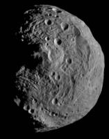
Another version of this beautiful new picture.
Phil
-------------------- ... because the Solar System ain't gonna map itself.
Also to be found posting similar content on https://mastodon.social/@PhilStooke Maps for download (free PDF: https://upload.wikimedia.org/wikipedia/comm...Cartography.pdf NOTE: everything created by me which I post on UMSF is considered to be in the public domain (NOT CC, public domain) |
|
|
|
|
|
|
Jul 18 2011, 08:26 PM
Post
#3
|
|
|
Junior Member Group: Members Posts: 21 Joined: 4-November 10 Member No.: 5509 |
Wow, stunning image.
While the south polar peak is either impact derived or tectonic, it certainly reminds me of Ayers rock in central Australia. Nice hard hard of rock that says "I am not going anywhere, no matter what you throw at me". Also the ripples around the south polar peak really look like ripples in a pond or maybe just wrinkles from shinkage. |
|
|
|
 Paolo Dawn Survey Orbit Phase Jul 17 2011, 09:09 AM
 dilo Good idea, Paolo!
Dawn's ion engine have b... Jul 17 2011, 02:13 PM pablogm1024 Would it be worth renaming the topic to Survey Orb... Jul 17 2011, 02:28 PM
dilo Good idea, Paolo!
Dawn's ion engine have b... Jul 17 2011, 02:13 PM pablogm1024 Would it be worth renaming the topic to Survey Orb... Jul 17 2011, 02:28 PM
 Bjorn Jonsson QUOTE (pablogm1024 @ Jul 17 2011, 02:28 P... Jul 17 2011, 03:18 PM dilo This is an answer to Greg question (from the old t... Jul 17 2011, 06:53 PM dilo With engines on, Dawn still decelerating, even tho... Jul 18 2011, 05:13 PM elakdawalla OK this is making me absolutely crazy. Another im... Jul 18 2011, 07:21 PM Stefan QUOTE (elakdawalla @ Jul 18 2011, 09:21 P... Jul 19 2011, 01:22 PM elakdawalla QUOTE (Stefan @ Jul 19 2011, 05:22 AM) Th... Jul 19 2011, 04:51 PM Stefan QUOTE (elakdawalla @ Jul 19 2011, 06:51 P... Jul 19 2011, 07:14 PM Stu Hands up, I don't understand all the tech stuf... Jul 18 2011, 07:37 PM Juramike Straight to Planetary Photojournal:
http://photojo... Jul 18 2011, 08:31 PM Stu Thanks for posting those links. Used the tiff file... Jul 18 2011, 09:03 PM Juramike That's really nice, Stu! Jul 18 2011, 09:49 PM volcanopele I think I shrunk the original image to something a... Jul 18 2011, 10:09 PM punkboi Congrats to the Dawn team for a successful orbit i... Jul 18 2011, 10:14 PM Stefan QUOTE (punkboi @ Jul 19 2011, 12:14 AM) C... Jul 19 2011, 01:36 PM belleraphon1 Thanks DAWN team for releasing these.
A lot to lo... Jul 18 2011, 10:36 PM Drkskywxlt Is that picture facing the south pole?
For some... Jul 18 2011, 10:59 PM ugordan A faux-color version based on color derived from H... Jul 18 2011, 11:09 PM kap QUOTE (ugordan @ Jul 18 2011, 03:09 PM) A... Jul 18 2011, 11:54 PM Juramike QUOTE (kap @ Jul 18 2011, 06:54 PM) What ... Jul 19 2011, 12:03 AM centsworth_II QUOTE (Drkskywxlt @ Jul 18 2011, 05:59 PM... Jul 19 2011, 11:35 AM Drkskywxlt QUOTE (centsworth_II @ Jul 19 2011, 07:35... Jul 19 2011, 12:37 PM centsworth_II QUOTE (Drkskywxlt @ Jul 19 2011, 07:37 AM... Jul 19 2011, 01:31 PM belleraphon1 Drkskywxlt:
Call it exhuberance.
Mirandian was ... Jul 18 2011, 11:19 PM MarkG Boys and girls, it's "Rampant Speculation... Jul 19 2011, 12:07 AM belleraphon1 "But is it not wild that we can even make sub... Jul 19 2011, 12:25 AM MarkG There is a big difference between Miranda and Vest... Jul 19 2011, 01:35 AM Steve G Sometimes it's easier just to rotate and crop,... Jul 19 2011, 01:36 AM nprev I think we'll definitely need a true global vi... Jul 19 2011, 01:36 AM Explorer1 How far will coverage of the northern hemisphere g... Jul 19 2011, 01:44 AM belleraphon1 Shaken or stirred?
That is the question. Jul 19 2011, 02:06 AM Gladstoner On second thought (or third), it looks like materi... Jul 19 2011, 03:13 AM MarkG Replies...
My understanding is that the North pole... Jul 19 2011, 04:02 AM Gladstoner QUOTE (MarkG @ Jul 18 2011, 11:02 PM) Als... Jul 19 2011, 04:36 AM tasp Love the "asteroid size comparison poster... Jul 19 2011, 04:12 AM antipode I can't wait to see...errrr...the antipode of ... Jul 19 2011, 04:34 AM Gladstoner A little bit of Vesta on Mars?:
And on Earth?:
... Jul 19 2011, 10:15 AM centsworth_II I was intrigued by the quick look Cassini got at t... Jul 19 2011, 11:17 AM Steve G The south polar crater is, by appearances, a flat ... Jul 19 2011, 02:08 PM algorimancer Was arrival facing the south polar crater planned,... Jul 19 2011, 02:37 PM Juramike Coordinated views of the normal and contrast-enhan... Jul 19 2011, 03:03 PM Phil Stooke Nice one, Mike.
The orange spot in the false co... Jul 19 2011, 03:11 PM MarkG QUOTE (Phil Stooke @ Jul 19 2011, 08:11 A... Jul 19 2011, 04:52 PM Phil Stooke Here's a composite to illustrate that.
Phil
Jul 19 2011, 04:33 PM elakdawalla You did the enlargement? It's great to actual... Jul 19 2011, 09:18 PM Stefan QUOTE (elakdawalla @ Jul 19 2011, 11:18 P... Jul 20 2011, 03:20 PM djellison QUOTE (Stefan @ Jul 20 2011, 07:20 AM) Ag... Jul 20 2011, 03:29 PM ugordan To be fair, that practice of magnifying otherwise ... Jul 20 2011, 03:49 PM tfisher QUOTE (Stefan @ Jul 20 2011, 11:20 AM) Th... Jul 21 2011, 04:05 PM elakdawalla QUOTE (tfisher @ Jul 21 2011, 08:05 AM) I... Jul 21 2011, 05:56 PM Stefan QUOTE (elakdawalla @ Jul 21 2011, 07:56 P... Jul 21 2011, 07:54 PM Juramike Here's a mashup of the image on the DLR websit... Jul 19 2011, 11:39 PM dilo An update on Dawn trajectory:
in spite of engine ... Jul 20 2011, 07:26 AM Greg Hullender Another interesting stat might be energy/kilogram.... Jul 20 2011, 02:13 PM dilo QUOTE (Greg Hullender @ Jul 20 2011, 02:1... Jul 22 2011, 07:16 AM machi Enlarging images is standard procedure. NASA use t... Jul 20 2011, 06:09 PM machi South pole of Vesta in stereo. Cross eye and anagl... Jul 20 2011, 09:41 PM Decepticon machi Thank you for the 3D!
My kids appreciat... Jul 20 2011, 09:48 PM Phil Stooke Fantastic! Thanks.
Phil Jul 20 2011, 10:11 PM ElkGroveDan QUOTE (machi @ Jul 20 2011, 01:41 PM) Sou... Jul 20 2011, 10:56 PM machi Thank you all!
I prepared one more cross-eye/... Jul 21 2011, 12:04 AM peter59 Today is Thursday, maybe we'll see images acqu... Jul 21 2011, 09:07 AM belleraphon1 Awesome!
Thanks machi Jul 21 2011, 11:17 AM Phil Stooke Recent images would be of a narrow crescent, but i... Jul 21 2011, 02:17 PM kap QUOTE (Phil Stooke @ Jul 21 2011, 06:17 A... Jul 21 2011, 05:35 PM Juramike With such a lumpy surface, the high-phase images s... Jul 21 2011, 02:25 PM Phil Stooke Hopefully this will be out of date very soon, but ... Jul 21 2011, 04:46 PM Phil Stooke Only the north polar area itself will be hidden - ... Jul 21 2011, 05:44 PM elakdawalla Regarding the enlargement, I like neither the blur... Jul 21 2011, 06:04 PM Stu QUOTE (elakdawalla @ Jul 21 2011, 06:56 P... Jul 21 2011, 09:00 PM elakdawalla I apologize for being such a pest. I think I don... Jul 21 2011, 09:06 PM tfisher another thing to question is the size of the error... Jul 21 2011, 09:45 PM elakdawalla What surprised me about that paper was that their ... Jul 21 2011, 09:52 PM tfisher QUOTE (elakdawalla @ Jul 21 2011, 04:52 P... Jul 21 2011, 10:21 PM Juramike New image! http://www.nasa.gov/mission_pages/... Jul 21 2011, 10:12 PM elakdawalla OK, now it looks like Hyperion. Vesta's an as... Jul 21 2011, 10:17 PM ugordan So *that's* what it was reminding me of! Jul 21 2011, 10:18 PM Mongo Has anybody looked at the effects of geometric per... Jul 21 2011, 10:23 PM Greg Hullender QUOTE (Mongo @ Jul 21 2011, 03:23 PM) Daw... Jul 22 2011, 01:49 AM jsheff I have a question about Vesta's reference grid... Jul 21 2011, 10:53 PM elakdawalla The answer to that question is in the paper that t... Jul 21 2011, 11:37 PM jsheff QUOTE (elakdawalla @ Jul 21 2011, 07:37 P... Jul 22 2011, 12:43 AM Mariner9 I think we have a new image just posted at JPL web... Jul 22 2011, 03:44 AM djellison QUOTE (Mariner9 @ Jul 21 2011, 07:44 PM) ... Jul 22 2011, 04:11 AM Phil Stooke I have been playing with a very rough map of Vesta... Jul 22 2011, 02:09 PM Phil Stooke Dawn's looping round the north side now, so th... Jul 22 2011, 07:53 PM elakdawalla Funny, and well spotted! I've attached th... Jul 22 2011, 08:04 PM Phil Stooke Here's a crater - middle of this view - with d... Jul 23 2011, 12:28 PM Juramike QUOTE (Phil Stooke @ Jul 23 2011, 07:28 A... Jul 24 2011, 02:50 AM ElkGroveDan It looks like maybe a fresh impact inside an older... Jul 23 2011, 02:31 PM Phil Stooke I'd say excavation of dark subsurface material... Jul 23 2011, 02:34 PM peter59 I'm curious if MYSTIC simulator use real data ... Jul 23 2011, 10:13 PM Gsnorgathon As Phil pointed out yesterday, that's Tethys. Jul 23 2011, 11:09 PM elakdawalla If our images of Vesta were already that good, we... Jul 24 2011, 02:38 AM Juramike BTW, here's the blink animation between the or... Jul 24 2011, 02:56 AM
Bjorn Jonsson QUOTE (pablogm1024 @ Jul 17 2011, 02:28 P... Jul 17 2011, 03:18 PM dilo This is an answer to Greg question (from the old t... Jul 17 2011, 06:53 PM dilo With engines on, Dawn still decelerating, even tho... Jul 18 2011, 05:13 PM elakdawalla OK this is making me absolutely crazy. Another im... Jul 18 2011, 07:21 PM Stefan QUOTE (elakdawalla @ Jul 18 2011, 09:21 P... Jul 19 2011, 01:22 PM elakdawalla QUOTE (Stefan @ Jul 19 2011, 05:22 AM) Th... Jul 19 2011, 04:51 PM Stefan QUOTE (elakdawalla @ Jul 19 2011, 06:51 P... Jul 19 2011, 07:14 PM Stu Hands up, I don't understand all the tech stuf... Jul 18 2011, 07:37 PM Juramike Straight to Planetary Photojournal:
http://photojo... Jul 18 2011, 08:31 PM Stu Thanks for posting those links. Used the tiff file... Jul 18 2011, 09:03 PM Juramike That's really nice, Stu! Jul 18 2011, 09:49 PM volcanopele I think I shrunk the original image to something a... Jul 18 2011, 10:09 PM punkboi Congrats to the Dawn team for a successful orbit i... Jul 18 2011, 10:14 PM Stefan QUOTE (punkboi @ Jul 19 2011, 12:14 AM) C... Jul 19 2011, 01:36 PM belleraphon1 Thanks DAWN team for releasing these.
A lot to lo... Jul 18 2011, 10:36 PM Drkskywxlt Is that picture facing the south pole?
For some... Jul 18 2011, 10:59 PM ugordan A faux-color version based on color derived from H... Jul 18 2011, 11:09 PM kap QUOTE (ugordan @ Jul 18 2011, 03:09 PM) A... Jul 18 2011, 11:54 PM Juramike QUOTE (kap @ Jul 18 2011, 06:54 PM) What ... Jul 19 2011, 12:03 AM centsworth_II QUOTE (Drkskywxlt @ Jul 18 2011, 05:59 PM... Jul 19 2011, 11:35 AM Drkskywxlt QUOTE (centsworth_II @ Jul 19 2011, 07:35... Jul 19 2011, 12:37 PM centsworth_II QUOTE (Drkskywxlt @ Jul 19 2011, 07:37 AM... Jul 19 2011, 01:31 PM belleraphon1 Drkskywxlt:
Call it exhuberance.
Mirandian was ... Jul 18 2011, 11:19 PM MarkG Boys and girls, it's "Rampant Speculation... Jul 19 2011, 12:07 AM belleraphon1 "But is it not wild that we can even make sub... Jul 19 2011, 12:25 AM MarkG There is a big difference between Miranda and Vest... Jul 19 2011, 01:35 AM Steve G Sometimes it's easier just to rotate and crop,... Jul 19 2011, 01:36 AM nprev I think we'll definitely need a true global vi... Jul 19 2011, 01:36 AM Explorer1 How far will coverage of the northern hemisphere g... Jul 19 2011, 01:44 AM belleraphon1 Shaken or stirred?
That is the question. Jul 19 2011, 02:06 AM Gladstoner On second thought (or third), it looks like materi... Jul 19 2011, 03:13 AM MarkG Replies...
My understanding is that the North pole... Jul 19 2011, 04:02 AM Gladstoner QUOTE (MarkG @ Jul 18 2011, 11:02 PM) Als... Jul 19 2011, 04:36 AM tasp Love the "asteroid size comparison poster... Jul 19 2011, 04:12 AM antipode I can't wait to see...errrr...the antipode of ... Jul 19 2011, 04:34 AM Gladstoner A little bit of Vesta on Mars?:
And on Earth?:
... Jul 19 2011, 10:15 AM centsworth_II I was intrigued by the quick look Cassini got at t... Jul 19 2011, 11:17 AM Steve G The south polar crater is, by appearances, a flat ... Jul 19 2011, 02:08 PM algorimancer Was arrival facing the south polar crater planned,... Jul 19 2011, 02:37 PM Juramike Coordinated views of the normal and contrast-enhan... Jul 19 2011, 03:03 PM Phil Stooke Nice one, Mike.
The orange spot in the false co... Jul 19 2011, 03:11 PM MarkG QUOTE (Phil Stooke @ Jul 19 2011, 08:11 A... Jul 19 2011, 04:52 PM Phil Stooke Here's a composite to illustrate that.
Phil
Jul 19 2011, 04:33 PM elakdawalla You did the enlargement? It's great to actual... Jul 19 2011, 09:18 PM Stefan QUOTE (elakdawalla @ Jul 19 2011, 11:18 P... Jul 20 2011, 03:20 PM djellison QUOTE (Stefan @ Jul 20 2011, 07:20 AM) Ag... Jul 20 2011, 03:29 PM ugordan To be fair, that practice of magnifying otherwise ... Jul 20 2011, 03:49 PM tfisher QUOTE (Stefan @ Jul 20 2011, 11:20 AM) Th... Jul 21 2011, 04:05 PM elakdawalla QUOTE (tfisher @ Jul 21 2011, 08:05 AM) I... Jul 21 2011, 05:56 PM Stefan QUOTE (elakdawalla @ Jul 21 2011, 07:56 P... Jul 21 2011, 07:54 PM Juramike Here's a mashup of the image on the DLR websit... Jul 19 2011, 11:39 PM dilo An update on Dawn trajectory:
in spite of engine ... Jul 20 2011, 07:26 AM Greg Hullender Another interesting stat might be energy/kilogram.... Jul 20 2011, 02:13 PM dilo QUOTE (Greg Hullender @ Jul 20 2011, 02:1... Jul 22 2011, 07:16 AM machi Enlarging images is standard procedure. NASA use t... Jul 20 2011, 06:09 PM machi South pole of Vesta in stereo. Cross eye and anagl... Jul 20 2011, 09:41 PM Decepticon machi Thank you for the 3D!
My kids appreciat... Jul 20 2011, 09:48 PM Phil Stooke Fantastic! Thanks.
Phil Jul 20 2011, 10:11 PM ElkGroveDan QUOTE (machi @ Jul 20 2011, 01:41 PM) Sou... Jul 20 2011, 10:56 PM machi Thank you all!
I prepared one more cross-eye/... Jul 21 2011, 12:04 AM peter59 Today is Thursday, maybe we'll see images acqu... Jul 21 2011, 09:07 AM belleraphon1 Awesome!
Thanks machi Jul 21 2011, 11:17 AM Phil Stooke Recent images would be of a narrow crescent, but i... Jul 21 2011, 02:17 PM kap QUOTE (Phil Stooke @ Jul 21 2011, 06:17 A... Jul 21 2011, 05:35 PM Juramike With such a lumpy surface, the high-phase images s... Jul 21 2011, 02:25 PM Phil Stooke Hopefully this will be out of date very soon, but ... Jul 21 2011, 04:46 PM Phil Stooke Only the north polar area itself will be hidden - ... Jul 21 2011, 05:44 PM elakdawalla Regarding the enlargement, I like neither the blur... Jul 21 2011, 06:04 PM Stu QUOTE (elakdawalla @ Jul 21 2011, 06:56 P... Jul 21 2011, 09:00 PM elakdawalla I apologize for being such a pest. I think I don... Jul 21 2011, 09:06 PM tfisher another thing to question is the size of the error... Jul 21 2011, 09:45 PM elakdawalla What surprised me about that paper was that their ... Jul 21 2011, 09:52 PM tfisher QUOTE (elakdawalla @ Jul 21 2011, 04:52 P... Jul 21 2011, 10:21 PM Juramike New image! http://www.nasa.gov/mission_pages/... Jul 21 2011, 10:12 PM elakdawalla OK, now it looks like Hyperion. Vesta's an as... Jul 21 2011, 10:17 PM ugordan So *that's* what it was reminding me of! Jul 21 2011, 10:18 PM Mongo Has anybody looked at the effects of geometric per... Jul 21 2011, 10:23 PM Greg Hullender QUOTE (Mongo @ Jul 21 2011, 03:23 PM) Daw... Jul 22 2011, 01:49 AM jsheff I have a question about Vesta's reference grid... Jul 21 2011, 10:53 PM elakdawalla The answer to that question is in the paper that t... Jul 21 2011, 11:37 PM jsheff QUOTE (elakdawalla @ Jul 21 2011, 07:37 P... Jul 22 2011, 12:43 AM Mariner9 I think we have a new image just posted at JPL web... Jul 22 2011, 03:44 AM djellison QUOTE (Mariner9 @ Jul 21 2011, 07:44 PM) ... Jul 22 2011, 04:11 AM Phil Stooke I have been playing with a very rough map of Vesta... Jul 22 2011, 02:09 PM Phil Stooke Dawn's looping round the north side now, so th... Jul 22 2011, 07:53 PM elakdawalla Funny, and well spotted! I've attached th... Jul 22 2011, 08:04 PM Phil Stooke Here's a crater - middle of this view - with d... Jul 23 2011, 12:28 PM Juramike QUOTE (Phil Stooke @ Jul 23 2011, 07:28 A... Jul 24 2011, 02:50 AM ElkGroveDan It looks like maybe a fresh impact inside an older... Jul 23 2011, 02:31 PM Phil Stooke I'd say excavation of dark subsurface material... Jul 23 2011, 02:34 PM peter59 I'm curious if MYSTIC simulator use real data ... Jul 23 2011, 10:13 PM Gsnorgathon As Phil pointed out yesterday, that's Tethys. Jul 23 2011, 11:09 PM elakdawalla If our images of Vesta were already that good, we... Jul 24 2011, 02:38 AM Juramike BTW, here's the blink animation between the or... Jul 24 2011, 02:56 AM |

|
Lo-Fi Version | Time is now: 26th September 2024 - 10:52 PM |
|
RULES AND GUIDELINES Please read the Forum Rules and Guidelines before posting. IMAGE COPYRIGHT |
OPINIONS AND MODERATION Opinions expressed on UnmannedSpaceflight.com are those of the individual posters and do not necessarily reflect the opinions of UnmannedSpaceflight.com or The Planetary Society. The all-volunteer UnmannedSpaceflight.com moderation team is wholly independent of The Planetary Society. The Planetary Society has no influence over decisions made by the UnmannedSpaceflight.com moderators. |
SUPPORT THE FORUM Unmannedspaceflight.com is funded by the Planetary Society. Please consider supporting our work and many other projects by donating to the Society or becoming a member. |
|