Cape York, Landfall! |

Cape York, Landfall! |
 Aug 10 2011, 06:30 AM Aug 10 2011, 06:30 AM
Post
#1
|
||
|
Senior Member  Group: Moderator Posts: 4279 Joined: 19-April 05 From: .br at .es Member No.: 253 |
Its finally time for a new thread. THE thread, I would say.
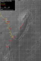
It is now sol 2681 and after virtually one thousand sols, beginning on 1683 when Opportunity left Victoria for good, and also after more than 21km driving on these flat fields, this little rover and obviously the brave missions people behind, made landfall on Cape York. A bunch of pictures and thumbnails are already on the ground (should be public in an hour or so) and the very limited data we can gather for the time being are just enough to guess a drive of around 60m. Ive prepared a new picture to use as a map to follow this part of the mission and which I will update, as usual, on the route map thread once more data are available. Heres a copy of it.
Use this thread for comments, discussions, mosaics, images result of activities at / after sol 2681 and keep using the Post Conjunction: Santa Maria to Cape York, The Journey to 'Spirit Point' thread for posts related with stuff from before sol 2681. |
|
 |
 
|
|
 |
|
Aug 11 2011, 06:26 AM
Post
#2
|
|
 Senior Member Group: Members Posts: 2228 Joined: 1-December 04 From: Marble Falls, Texas, USA Member No.: 116 |
I guess it is stating the obvious, but the bedrock here appears to be a planed off jumble of ejecta blocks.
-------------------- ...Tom
I'm not a Space Fan, I'm a Space Exploration Enthusiast. |
|
|
|
|
Aug 11 2011, 11:45 AM
Post
#3
|
||
 Member Group: Members Posts: 156 Joined: 8-February 04 From: Phoenix, AZ USA Member No.: 9 |
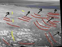
QUOTE (CosmicRocker @ Aug 11 2011, 12:26 AM)  the bedrock here appears to be a planed off jumble of ejecta blocks. Hmmm, I'm not so sure, Tom. Here is a quick photo interpretation of a piece of Mike Howard's pan:
The unit the rover is on now seems like it could be a highly fractured eolian sandstone, maybe similar to the lower part of the Burns formation seen at Victoria and Endurance. Some of the fractures are filled with bright-looking minerals. Also intriguing are the horizontal features on the slope and crater floor in the distance. Here is a key of my interpretations: red lines: large-scale trough cross bed foresets black arrows: apparent sediment transport direction yellow lines: mineralized sub-vertical fractures blue lines: receding shorelines?!?!?! -------------------- Tim Demko
BioLink site |
|
|
|
|
|
 Tesheiner Cape York Aug 10 2011, 06:30 AM
 Astro0 Welcome to Cape York and hello Odyssey crater... Aug 10 2011, 07:39 AM Tesheiner WOW, just WOW! Aug 10 2011, 07:41 AM
 MoreInput Unglaublich!
Fantastic!
- 1000 Sols, and... Aug 10 2011, 07:46 AM Astro0 ...and the navcam
Aug 10 2011, 07:46 AM Sunspot Interesting feature...there is a thin line of very... Aug 10 2011, 07:54 AM Gladstoner . Aug 10 2011, 08:05 AM walfy Breathtaking!
Aug 10 2011, 08:06 AM Gladstoner . Aug 10 2011, 08:10 AM walfy Those rocks and the background!
Can't g... Aug 10 2011, 08:21 AM ugordan Wow. Dare I say this is the most impressive vista ... Aug 10 2011, 08:31 AM walfy Just one more for tonight:
Extraordinary. It... Aug 10 2011, 08:49 AM kenny It looks so different at ground level, as we final... Aug 10 2011, 09:18 AM MahFL QUOTE (kenny @ Aug 10 2011, 10:18 AM) And... Aug 10 2011, 12:45 PM Julius QUOTE (walfy @ Aug 10 2011, 09:49 AM) Jus... Aug 10 2011, 12:33 PM Julius QUOTE (Sunspot @ Aug 10 2011, 08:54 AM) I... Aug 10 2011, 12:04 PM Gladstoner . Aug 10 2011, 07:55 AM Astro0 I would have been faster but the phone rang!
... Aug 10 2011, 07:55 AM MichaelT What a day! Fantastic images! I am looking... Aug 10 2011, 08:03 AM Explorer1 It's like the summit of Husband Hill, Victoria... Aug 10 2011, 08:08 AM Astro0 Just one more to satisfy my inner artist before I ... Aug 10 2011, 08:30 AM neo56 Absolutely fantastic !!! The landscape... Aug 10 2011, 08:43 AM climber I agree, this is (yet another) landing day! An... Aug 10 2011, 08:46 AM Floyd The perfect new mission--fantastic views plus fant... Aug 10 2011, 09:42 AM MoreInput Even in the navcam view we don't see anything ... Aug 10 2011, 09:56 AM Burmese I suspect they will want to pull up just a bit clo... Aug 10 2011, 10:17 AM neo56 Here is the anaglyph of the sol 2681 Pancam view. ... Aug 10 2011, 10:27 AM Nix fun-fun-fun
http://www.flickr.com/photos/7994641... Aug 10 2011, 10:38 AM stevelu Here we go
wOW
http://qt.exploratorium.edu/mars/... Aug 10 2011, 10:44 AM Ant103 Just amazing !
Astro0, with an extended s... Aug 10 2011, 12:07 PM Julius I just wonder what that white streak represents?? Aug 10 2011, 12:21 PM mhoward QUOTE (Julius @ Aug 10 2011, 05:21 AM) I ... Aug 10 2011, 03:03 PM ElkGroveDan QUOTE (Julius @ Aug 10 2011, 05:21 AM) I ... Aug 10 2011, 03:26 PM belleraphon1 Magnificent.... new mission on new terrain!
C... Aug 10 2011, 12:22 PM nprev What a thing to wake up to!!!
W... Aug 10 2011, 12:25 PM pospa WOW! Now its obvious why this cater's nam... Aug 10 2011, 01:00 PM centsworth_II QUOTE (pospa @ Aug 10 2011, 08:00 AM) WOW... Aug 10 2011, 03:13 PM Phil Stooke Phil checking in from Medford, Nova Scotia (where ... Aug 10 2011, 01:44 PM Fran Ontanaya Congratulations to all the team! What a journe... Aug 10 2011, 01:47 PM JayB http://opportunityendeavour.blogspot.com/2...ject-... Aug 10 2011, 01:48 PM Matt Lenda QUOTE (JayB @ Aug 10 2011, 06:48 AM) htt... Aug 10 2011, 05:25 PM MoreInput Just hope that Oppy won't get stuck on CY Aug 10 2011, 05:31 PM ElkGroveDan It's a bit like the first time you drive to th... Aug 10 2011, 01:52 PM djellison QUOTE (ElkGroveDan @ Aug 10 2011, 06:52 A... Aug 10 2011, 01:58 PM BrianL QUOTE (djellison @ Aug 10 2011, 07:58 AM)... Aug 10 2011, 04:42 PM mhoward 2681 Pancam: Aug 10 2011, 01:53 PM ElkGroveDan I have to say that this anaglyph and crop that wal... Aug 10 2011, 02:09 PM mhoward QUOTE (ElkGroveDan @ Aug 10 2011, 07:09 A... Aug 10 2011, 02:30 PM mhoward Sol 2681 Navcam, facing east. (Sorry for the delay... Aug 10 2011, 02:13 PM Stu Just got back from work. Did I miss anything? Aug 10 2011, 03:13 PM fredk Wow. I mean holy &*^^#*** (*&&*## ... Aug 10 2011, 03:15 PM Pertinax QUOTE (fredk @ Aug 10 2011, 11:15 AM) It... Aug 10 2011, 04:27 PM micvoo Absolutely stunning, and already looking forward t... Aug 10 2011, 03:30 PM ilbasso We've been driving over featureless terrain fo... Aug 10 2011, 03:41 PM MoreInput Official press release: http://marsrover.nasa.gov/... Aug 10 2011, 03:51 PM centsworth_II QUOTE (ilbasso @ Aug 10 2011, 11:41 AM) .... Aug 10 2011, 03:55 PM fredk As if starting a new (probably multi-year) mission... Aug 10 2011, 04:05 PM centsworth_II QUOTE (fredk @ Aug 10 2011, 12:05 PM) ...... Aug 10 2011, 04:07 PM Stu I caught my first glimpse of these incredible imag... Aug 10 2011, 04:31 PM Julius I'm curious to see MI images of the new terrai... Aug 10 2011, 05:21 PM Stu Colourised portrait of Odyssey Crater...
http://t... Aug 10 2011, 05:49 PM Nix colourized ?? Aug 10 2011, 05:59 PM brellis QUOTE I even said trying was silly. I remember you... Aug 10 2011, 06:08 PM Stu QUOTE (Nix @ Aug 10 2011, 06:59 PM) colou... Aug 10 2011, 06:09 PM Nix I was thinking about the recent discussion on colo... Aug 10 2011, 06:16 PM elakdawalla Fredk, any chance your mystery men will make an ap... Aug 10 2011, 06:20 PM mhoward QUOTE (elakdawalla @ Aug 10 2011, 11:20 A... Aug 10 2011, 06:33 PM fredk I really should be getting to the airport , but h... Aug 10 2011, 07:32 PM belleraphon1 Today is bill paying day for me. Which I do online... Aug 10 2011, 08:03 PM Arkarch Thank-you for the continuing ride Opportunity, JPL... Aug 10 2011, 09:38 PM CosmicRocker QUOTE (Sunspot @ Aug 10 2011, 02:54 AM) I... Aug 10 2011, 10:00 PM nprev Finally home from work, and have reviewed the thre... Aug 11 2011, 12:09 AM NickF Here's my take on the sol 2681 L2 pancam image... Aug 11 2011, 12:17 AM Burmese QUOTE (NickF @ Aug 10 2011, 06:17 PM) Her... Aug 11 2011, 12:50 AM NickF QUOTE (Burmese @ Aug 10 2011, 07:50 PM) T... Aug 11 2011, 02:29 AM lyford Thanks to all the engineers and scientists who... Aug 11 2011, 12:33 AM eoincampbell Thank you all again at UMSF for a memorable past c... Aug 11 2011, 02:14 AM Gladstoner . Aug 11 2011, 02:28 AM mhoward Full right Navcam panorama for 2681-2682
Quickt... Aug 11 2011, 02:28 AM Matt Lenda QUOTE (mhoward @ Aug 10 2011, 06:28 PM) F... Aug 11 2011, 03:19 AM Tesheiner QUOTE (mhoward @ Aug 11 2011, 04:28 AM) F... Aug 11 2011, 10:07 AM kenny QUOTE (mhoward @ Aug 11 2011, 03:28 AM) F... Aug 11 2011, 09:32 PM nprev NickF, in your panorama it looks very much like a ... Aug 11 2011, 02:39 AM brellis Re: NickF's pic -- If Endeavour crater is the ... Aug 11 2011, 03:19 AM Zeke4ther QUOTE (NickF @ Aug 10 2011, 07:17 PM) Her... Aug 11 2011, 05:48 AM neo56 A set of L257 of Pathfinder Mound taken on sol 267... Aug 11 2011, 09:02 AM Stu A look back at "Gibraltar", Oppy's r... Aug 11 2011, 09:27 AM john_s The nature of the contact between the sulfate sedi... Aug 11 2011, 02:02 PM ups Wow, I can't believe we're finally 'th... Aug 11 2011, 02:15 PM centsworth_II This armchair geologist is at a total loss. The o... Aug 11 2011, 02:23 PM Stu QUOTE (centsworth_II @ Aug 11 2011, 03:23... Aug 11 2011, 02:34 PM centsworth_II QUOTE (Stu @ Aug 11 2011, 10:34 AM) ...sh... Aug 11 2011, 02:54 PM Stu That scale size demonstration is **brilliant**... Aug 11 2011, 03:00 PM SteveM Mini TES hasn't been used for a long time. Th... Aug 11 2011, 03:38 PM Explorer1 It's still covered, according to Emily's l... Aug 11 2011, 04:40 PM SteveM If Emily says "Mini TES ... is hopelessly con... Aug 11 2011, 04:56 PM rschare So, what instruments can they still use to determi... Aug 11 2011, 04:55 PM climber QUOTE (rschare @ Aug 11 2011, 05:55 PM) S... Aug 11 2011, 05:55 PM
MoreInput Unglaublich!
Fantastic!
- 1000 Sols, and... Aug 10 2011, 07:46 AM Astro0 ...and the navcam
Aug 10 2011, 07:46 AM Sunspot Interesting feature...there is a thin line of very... Aug 10 2011, 07:54 AM Gladstoner . Aug 10 2011, 08:05 AM walfy Breathtaking!
Aug 10 2011, 08:06 AM Gladstoner . Aug 10 2011, 08:10 AM walfy Those rocks and the background!
Can't g... Aug 10 2011, 08:21 AM ugordan Wow. Dare I say this is the most impressive vista ... Aug 10 2011, 08:31 AM walfy Just one more for tonight:
Extraordinary. It... Aug 10 2011, 08:49 AM kenny It looks so different at ground level, as we final... Aug 10 2011, 09:18 AM MahFL QUOTE (kenny @ Aug 10 2011, 10:18 AM) And... Aug 10 2011, 12:45 PM Julius QUOTE (walfy @ Aug 10 2011, 09:49 AM) Jus... Aug 10 2011, 12:33 PM Julius QUOTE (Sunspot @ Aug 10 2011, 08:54 AM) I... Aug 10 2011, 12:04 PM Gladstoner . Aug 10 2011, 07:55 AM Astro0 I would have been faster but the phone rang!
... Aug 10 2011, 07:55 AM MichaelT What a day! Fantastic images! I am looking... Aug 10 2011, 08:03 AM Explorer1 It's like the summit of Husband Hill, Victoria... Aug 10 2011, 08:08 AM Astro0 Just one more to satisfy my inner artist before I ... Aug 10 2011, 08:30 AM neo56 Absolutely fantastic !!! The landscape... Aug 10 2011, 08:43 AM climber I agree, this is (yet another) landing day! An... Aug 10 2011, 08:46 AM Floyd The perfect new mission--fantastic views plus fant... Aug 10 2011, 09:42 AM MoreInput Even in the navcam view we don't see anything ... Aug 10 2011, 09:56 AM Burmese I suspect they will want to pull up just a bit clo... Aug 10 2011, 10:17 AM neo56 Here is the anaglyph of the sol 2681 Pancam view. ... Aug 10 2011, 10:27 AM Nix fun-fun-fun
http://www.flickr.com/photos/7994641... Aug 10 2011, 10:38 AM stevelu Here we go
wOW
http://qt.exploratorium.edu/mars/... Aug 10 2011, 10:44 AM Ant103 Just amazing !
Astro0, with an extended s... Aug 10 2011, 12:07 PM Julius I just wonder what that white streak represents?? Aug 10 2011, 12:21 PM mhoward QUOTE (Julius @ Aug 10 2011, 05:21 AM) I ... Aug 10 2011, 03:03 PM ElkGroveDan QUOTE (Julius @ Aug 10 2011, 05:21 AM) I ... Aug 10 2011, 03:26 PM belleraphon1 Magnificent.... new mission on new terrain!
C... Aug 10 2011, 12:22 PM nprev What a thing to wake up to!!!
W... Aug 10 2011, 12:25 PM pospa WOW! Now its obvious why this cater's nam... Aug 10 2011, 01:00 PM centsworth_II QUOTE (pospa @ Aug 10 2011, 08:00 AM) WOW... Aug 10 2011, 03:13 PM Phil Stooke Phil checking in from Medford, Nova Scotia (where ... Aug 10 2011, 01:44 PM Fran Ontanaya Congratulations to all the team! What a journe... Aug 10 2011, 01:47 PM JayB http://opportunityendeavour.blogspot.com/2...ject-... Aug 10 2011, 01:48 PM Matt Lenda QUOTE (JayB @ Aug 10 2011, 06:48 AM) htt... Aug 10 2011, 05:25 PM MoreInput Just hope that Oppy won't get stuck on CY Aug 10 2011, 05:31 PM ElkGroveDan It's a bit like the first time you drive to th... Aug 10 2011, 01:52 PM djellison QUOTE (ElkGroveDan @ Aug 10 2011, 06:52 A... Aug 10 2011, 01:58 PM BrianL QUOTE (djellison @ Aug 10 2011, 07:58 AM)... Aug 10 2011, 04:42 PM mhoward 2681 Pancam: Aug 10 2011, 01:53 PM ElkGroveDan I have to say that this anaglyph and crop that wal... Aug 10 2011, 02:09 PM mhoward QUOTE (ElkGroveDan @ Aug 10 2011, 07:09 A... Aug 10 2011, 02:30 PM mhoward Sol 2681 Navcam, facing east. (Sorry for the delay... Aug 10 2011, 02:13 PM Stu Just got back from work. Did I miss anything? Aug 10 2011, 03:13 PM fredk Wow. I mean holy &*^^#*** (*&&*## ... Aug 10 2011, 03:15 PM Pertinax QUOTE (fredk @ Aug 10 2011, 11:15 AM) It... Aug 10 2011, 04:27 PM micvoo Absolutely stunning, and already looking forward t... Aug 10 2011, 03:30 PM ilbasso We've been driving over featureless terrain fo... Aug 10 2011, 03:41 PM MoreInput Official press release: http://marsrover.nasa.gov/... Aug 10 2011, 03:51 PM centsworth_II QUOTE (ilbasso @ Aug 10 2011, 11:41 AM) .... Aug 10 2011, 03:55 PM fredk As if starting a new (probably multi-year) mission... Aug 10 2011, 04:05 PM centsworth_II QUOTE (fredk @ Aug 10 2011, 12:05 PM) ...... Aug 10 2011, 04:07 PM Stu I caught my first glimpse of these incredible imag... Aug 10 2011, 04:31 PM Julius I'm curious to see MI images of the new terrai... Aug 10 2011, 05:21 PM Stu Colourised portrait of Odyssey Crater...
http://t... Aug 10 2011, 05:49 PM Nix colourized ?? Aug 10 2011, 05:59 PM brellis QUOTE I even said trying was silly. I remember you... Aug 10 2011, 06:08 PM Stu QUOTE (Nix @ Aug 10 2011, 06:59 PM) colou... Aug 10 2011, 06:09 PM Nix I was thinking about the recent discussion on colo... Aug 10 2011, 06:16 PM elakdawalla Fredk, any chance your mystery men will make an ap... Aug 10 2011, 06:20 PM mhoward QUOTE (elakdawalla @ Aug 10 2011, 11:20 A... Aug 10 2011, 06:33 PM fredk I really should be getting to the airport , but h... Aug 10 2011, 07:32 PM belleraphon1 Today is bill paying day for me. Which I do online... Aug 10 2011, 08:03 PM Arkarch Thank-you for the continuing ride Opportunity, JPL... Aug 10 2011, 09:38 PM CosmicRocker QUOTE (Sunspot @ Aug 10 2011, 02:54 AM) I... Aug 10 2011, 10:00 PM nprev Finally home from work, and have reviewed the thre... Aug 11 2011, 12:09 AM NickF Here's my take on the sol 2681 L2 pancam image... Aug 11 2011, 12:17 AM Burmese QUOTE (NickF @ Aug 10 2011, 06:17 PM) Her... Aug 11 2011, 12:50 AM NickF QUOTE (Burmese @ Aug 10 2011, 07:50 PM) T... Aug 11 2011, 02:29 AM lyford Thanks to all the engineers and scientists who... Aug 11 2011, 12:33 AM eoincampbell Thank you all again at UMSF for a memorable past c... Aug 11 2011, 02:14 AM Gladstoner . Aug 11 2011, 02:28 AM mhoward Full right Navcam panorama for 2681-2682
Quickt... Aug 11 2011, 02:28 AM Matt Lenda QUOTE (mhoward @ Aug 10 2011, 06:28 PM) F... Aug 11 2011, 03:19 AM Tesheiner QUOTE (mhoward @ Aug 11 2011, 04:28 AM) F... Aug 11 2011, 10:07 AM kenny QUOTE (mhoward @ Aug 11 2011, 03:28 AM) F... Aug 11 2011, 09:32 PM nprev NickF, in your panorama it looks very much like a ... Aug 11 2011, 02:39 AM brellis Re: NickF's pic -- If Endeavour crater is the ... Aug 11 2011, 03:19 AM Zeke4ther QUOTE (NickF @ Aug 10 2011, 07:17 PM) Her... Aug 11 2011, 05:48 AM neo56 A set of L257 of Pathfinder Mound taken on sol 267... Aug 11 2011, 09:02 AM Stu A look back at "Gibraltar", Oppy's r... Aug 11 2011, 09:27 AM john_s The nature of the contact between the sulfate sedi... Aug 11 2011, 02:02 PM ups Wow, I can't believe we're finally 'th... Aug 11 2011, 02:15 PM centsworth_II This armchair geologist is at a total loss. The o... Aug 11 2011, 02:23 PM Stu QUOTE (centsworth_II @ Aug 11 2011, 03:23... Aug 11 2011, 02:34 PM centsworth_II QUOTE (Stu @ Aug 11 2011, 10:34 AM) ...sh... Aug 11 2011, 02:54 PM Stu That scale size demonstration is **brilliant**... Aug 11 2011, 03:00 PM SteveM Mini TES hasn't been used for a long time. Th... Aug 11 2011, 03:38 PM Explorer1 It's still covered, according to Emily's l... Aug 11 2011, 04:40 PM SteveM If Emily says "Mini TES ... is hopelessly con... Aug 11 2011, 04:56 PM rschare So, what instruments can they still use to determi... Aug 11 2011, 04:55 PM climber QUOTE (rschare @ Aug 11 2011, 05:55 PM) S... Aug 11 2011, 05:55 PM |

|
Lo-Fi Version | Time is now: 26th September 2024 - 12:40 PM |
|
RULES AND GUIDELINES Please read the Forum Rules and Guidelines before posting. IMAGE COPYRIGHT |
OPINIONS AND MODERATION Opinions expressed on UnmannedSpaceflight.com are those of the individual posters and do not necessarily reflect the opinions of UnmannedSpaceflight.com or The Planetary Society. The all-volunteer UnmannedSpaceflight.com moderation team is wholly independent of The Planetary Society. The Planetary Society has no influence over decisions made by the UnmannedSpaceflight.com moderators. |
SUPPORT THE FORUM Unmannedspaceflight.com is funded by the Planetary Society. Please consider supporting our work and many other projects by donating to the Society or becoming a member. |
|