Cape York, Landfall! |

Cape York, Landfall! |
 Aug 10 2011, 06:30 AM Aug 10 2011, 06:30 AM
Post
#1
|
||
|
Senior Member  Group: Moderator Posts: 4279 Joined: 19-April 05 From: .br at .es Member No.: 253 |
Its finally time for a new thread. THE thread, I would say.
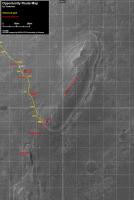
It is now sol 2681 and after virtually one thousand sols, beginning on 1683 when Opportunity left Victoria for good, and also after more than 21km driving on these flat fields, this little rover and obviously the brave missions people behind, made landfall on Cape York. A bunch of pictures and thumbnails are already on the ground (should be public in an hour or so) and the very limited data we can gather for the time being are just enough to guess a drive of around 60m. Ive prepared a new picture to use as a map to follow this part of the mission and which I will update, as usual, on the route map thread once more data are available. Heres a copy of it.
Use this thread for comments, discussions, mosaics, images result of activities at / after sol 2681 and keep using the Post Conjunction: Santa Maria to Cape York, The Journey to 'Spirit Point' thread for posts related with stuff from before sol 2681. |
|
 |
 
|
|
 |
|
Aug 17 2011, 03:39 AM
Post
#2
|
|
 Member Group: Members Posts: 754 Joined: 9-February 07 Member No.: 1700 |
Innocent comment about Sol 2686 color pan: it looks like some of those rocks plunged into the sand. Is that possible?
edit, more specifically -- it looks like some of the rocks in Ant's post#185 plunged into the sand pretty recently. The tall skinny rock to the right about 5-10% off-center in the distance looks like it has its own little pile of ejecta. Is that possible, and if so have we seen anything like this? |
|
|
|
|
Aug 17 2011, 04:50 AM
Post
#3
|
|
 Administrator Group: Admin Posts: 5172 Joined: 4-August 05 From: Pasadena, CA, USA, Earth Member No.: 454 |
QUOTE (brellis @ Aug 16 2011, 08:39 PM)  Innocent comment about Sol 2686 color pan: it looks like some of those rocks plunged into the sand. Is that possible? I don't see it. When I see something steep with some stuff at the base of the steep slope, my general assumption is that some weathering process attacked the rock, and the stuff at the base is chunks that fell off of it. What I do find striking is how much rockier this area is than anything Opportunity's seen before. So far in the mission, everywhere you see rock, except in ejecta from very recent craters, the rock has been scoured flat by wind and sand. This new rock is more resistant to Meridiani's sandblasting winds -- maybe not as hard as the Gusev basalts, but harder than Meridiani sulfates. They better be cautious with the RAT! -------------------- My website - My Patreon - @elakdawalla on Twitter - Please support unmannedspaceflight.com by donating here.
|
|
|
|
 Tesheiner Cape York Aug 10 2011, 06:30 AM
 Bobby WOW is the best word to Describe what I'm seei... Aug 12 2011, 03:46 AM
 Eutectic QUOTE (Bobby @ Aug 11 2011, 09:46 PM) 1. ... Aug 12 2011, 04:53 AM centsworth_II QUOTE (Bobby @ Aug 11 2011, 10:46 PM) I w... Aug 12 2011, 12:16 PM
 Pertinax QUOTE (Bobby @ Aug 11 2011, 10:46 PM) I w... Aug 12 2011, 01:12 PM centsworth_II QUOTE (Pertinax @ Aug 12 2011, 08:12 AM) ... Aug 12 2011, 01:26 PM Tesheiner QUOTE (john_s @ Aug 12 2011, 02:03 AM) Is... Aug 12 2011, 06:04 AM Tesheiner Today's drive moved the rover about 15m toward... Aug 12 2011, 06:11 AM walfy A little more of the crater's floor in view to... Aug 12 2011, 08:32 AM Juramike Those rocks look really enticing ('specially t... Aug 12 2011, 10:59 AM charborob Navcam panorama from Oppy's current position:
Aug 12 2011, 11:34 AM Astro0 Two views of 'big rock' on Odyssey's r... Aug 12 2011, 12:45 PM micvoo QUOTE (Astro0 @ Aug 12 2011, 02:45 PM) Tw... Aug 12 2011, 03:46 PM stevelu QUOTE (Astro0 @ Aug 12 2011, 04:45 AM) Tw... Aug 13 2011, 04:10 AM climber The other face of the Big Rock look accessible on ... Aug 12 2011, 04:15 PM mhoward 2683 Navcams: Aug 12 2011, 04:35 PM Stu QUOTE (cIclops @ Aug 12 2011, 06:26 PM) I... Aug 12 2011, 05:59 PM kenny QUOTE (Stu @ Aug 12 2011, 06:59 PM) I rea... Aug 12 2011, 06:42 PM Matt Lenda QUOTE (kenny @ Aug 12 2011, 10:42 AM) I... Aug 12 2011, 08:09 PM Tesheiner QUOTE (Matt Lenda @ Aug 12 2011, 10:09 PM... Aug 12 2011, 08:44 PM monty python QUOTE (Tesheiner @ Aug 12 2011, 03:44 PM)... Aug 13 2011, 04:58 AM Matt Lenda QUOTE (monty python @ Aug 12 2011, 08:58 ... Aug 13 2011, 06:50 AM Stu Thumbnailcolourovision version of Odyssey...
Ca... Aug 12 2011, 06:20 PM brellis As fun as vertical stretch is, it's nice to se... Aug 12 2011, 08:26 PM ElkGroveDan Well hello Cyclops, keeping an eye on Odyssey, are... Aug 12 2011, 08:29 PM brellis In Ant's panorama from Post #2 in this thread,... Aug 12 2011, 08:48 PM centsworth_II QUOTE (brellis @ Aug 12 2011, 03:48 PM) I... Aug 12 2011, 09:25 PM ElkGroveDan Navcam pan - not enough images for color yet Aug 12 2011, 08:59 PM Floyd Brellis: Yes, you will have to go back to the ear... Aug 12 2011, 09:05 PM brellis Yes, 2centsworth. I had a feeling we'd seen t... Aug 12 2011, 10:20 PM HughFromAlice It's been exciting looking forward....... so j... Aug 13 2011, 11:32 AM Oersted Back on Titan Aug 13 2011, 07:45 PM HughFromAlice QUOTE (Oersted @ Aug 14 2011, 05:15 AM) B... Aug 13 2011, 11:55 PM Sunspot Odyysey Aug 13 2011, 08:45 PM centsworth_II QUOTE (Sunspot @ Aug 13 2011, 04:45 PM) O... Aug 13 2011, 09:19 PM ugordan QUOTE (centsworth_II @ Aug 13 2011, 11:19... Aug 13 2011, 09:46 PM HughFromAlice QUOTE (centsworth_II @ Aug 14 2011, 06:49... Aug 14 2011, 12:09 AM brellis oh, to see some rover tread marks on Titan! Aug 13 2011, 11:11 PM stevelu This seems to be the only full pancam image that... Aug 14 2011, 05:26 AM Astro0 QUOTE (stevelu @ Aug 14 2011, 03:26 PM) S... Aug 14 2011, 06:04 AM djellison I thought we were done with the colorization debat... Aug 14 2011, 05:34 AM Tesheiner And ... Zap! We were teletransported to Gusev... Aug 14 2011, 07:56 AM stewjack QUOTE (Tesheiner @ Aug 14 2011, 02:56 AM)... Aug 14 2011, 01:49 PM Stu Actually, when I saw that big, flat-topped slab of... Aug 14 2011, 11:02 AM kenny Yes, memories of the Rock Garden where there was a... Aug 14 2011, 01:16 PM fredk Hmmm... Yeah, sounds like those bright, flat tops... Aug 14 2011, 01:48 PM mhoward Sol 2685 Aug 14 2011, 03:28 PM OWW Are these boulders part of Cape York or the Odysse... Aug 14 2011, 04:43 PM Eutectic QUOTE (OWW @ Aug 14 2011, 10:43 AM) Are t... Aug 14 2011, 11:02 PM Oersted It's funny, mhoward, your upper thumbnail look... Aug 14 2011, 05:12 PM Stu The Tracking site IDs "Big Rock" as ... Aug 14 2011, 05:57 PM siravan Well, there is Ridout lake: http://travelingluck.c... Aug 14 2011, 06:24 PM stevesliva Bastardization of redoubt.
[Edit] And that gets ... Aug 14 2011, 06:59 PM MarkG The Odyssey crater ejecta may reflect the strength... Aug 15 2011, 12:48 AM Jam Butty QUOTE (Astro0 @ Aug 14 2011, 07:04 AM) Re... Aug 15 2011, 01:06 AM Explorer1 Flicker gifs are great for those of us without red... Aug 15 2011, 02:31 AM dilo Today's new PanoCam Odyssey images combined in... Aug 15 2011, 09:18 AM kenny QUOTE (dilo @ Aug 15 2011, 10:18 AM) ..an... Aug 15 2011, 10:23 AM ugordan My color version of the two frame pano:
Aug 15 2011, 01:24 PM neo56 Pancam color view taken on sol 2686 and Navcam pan... Aug 15 2011, 10:06 AM mhoward More 2686 Navcams Aug 15 2011, 01:10 PM Stu QUOTE (ugordan @ Aug 15 2011, 02:24 PM) M... Aug 15 2011, 01:42 PM ugordan Well, I always kinda figured "why bother?... Aug 15 2011, 01:49 PM tedstryk QUOTE (ugordan @ Aug 15 2011, 02:49 PM) W... Aug 15 2011, 07:29 PM ugordan QUOTE (tedstryk @ Aug 15 2011, 09:29 PM) ... Aug 15 2011, 10:00 PM Stu Always a place for your MER work here, I'm sur... Aug 15 2011, 01:58 PM brellis My eyes are spoiled rotten visiting this thread ev... Aug 15 2011, 02:42 PM Stu 3D view of "Ridout"...
Aug 15 2011, 03:07 PM algorimancer QUOTE (Stu @ Aug 15 2011, 09:07 AM) 3D vi... Aug 15 2011, 03:16 PM ElkGroveDan Shamelessly stealing Stu's image to bring out ... Aug 15 2011, 03:18 PM john_s QUOTE (ElkGroveDan @ Aug 15 2011, 08:18 A... Aug 15 2011, 04:50 PM marsophile The blueberry lag deposit seems to have disappeare... Aug 15 2011, 03:32 PM Jam Butty I was thinking the same thing.
Here is an L2,5,7 ... Aug 15 2011, 04:03 PM Stu Colour mosaic of surface... waaay too big to post ... Aug 15 2011, 04:38 PM Floyd The blue stones look very familiar, the pink/rose ... Aug 15 2011, 05:52 PM walfy Beautiful rocks out there:
A welcoming place ... Aug 15 2011, 07:10 PM Nirgal QUOTE (walfy @ Aug 15 2011, 09:10 PM) Bea... Aug 15 2011, 08:59 PM jasedm I still can't quite believe we're here aft... Aug 15 2011, 09:48 PM Jam Butty Sol 2685
Navcam flicker gif of the flat-topped roc... Aug 15 2011, 10:40 PM Tesheiner QUOTE (Jam Butty @ Aug 16 2011, 12:40 AM)... Aug 16 2011, 08:13 AM monty python Wow! I just looked at the august 15th pancams ... Aug 16 2011, 12:59 AM Matt Lenda QUOTE (monty python @ Aug 15 2011, 05:59 ... Aug 16 2011, 04:41 AM Jam Butty Thanks Tesheiner.
I hope you're right, can... Aug 16 2011, 01:18 PM tanjent It probably makes sense to give priority to the ca... Aug 16 2011, 01:48 PM Ant103 In waiting for new pics, Sol 2686 color pan :
Th... Aug 17 2011, 02:03 AM nprev In North America, anyhow, if you move in any direc... Aug 17 2011, 02:48 AM Eutectic QUOTE (elakdawalla @ Aug 16 2011, 10:50 P... Aug 17 2011, 05:05 AM eoincampbell Yes Brellis, I ask for clues in that beautiful sce... Aug 17 2011, 04:40 AM kenny I think the point for me is not the detritus at th... Aug 17 2011, 08:27 AM Tesheiner A couple of hazcam pics from sol 2688 are availabl... Aug 17 2011, 08:36 AM Matt Lenda QUOTE (Tesheiner @ Aug 17 2011, 01:36 AM)... Aug 17 2011, 01:02 PM Floyd QUOTE (Matt Lenda @ Aug 17 2011, 09:02 AM... Aug 17 2011, 01:29 PM Deimos P1254 -- front_haz_fault_pri15_4bpp -- from sol B/... Aug 17 2011, 01:29 PM Oersted Those faulted drives we've had a couple of rec... Aug 17 2011, 09:18 AM Jam Butty Nothing new here,
just a reworking of the Sol 2685... Aug 17 2011, 11:26 AM Stu "Tisdale" (2?) in colour...
Aug 17 2011, 02:31 PM Phil Stooke Back at last! I'm a bit late, but here... Aug 17 2011, 02:38 PM kenny Spectacular! ... the south end of Cape York in... Aug 17 2011, 02:52 PM
Pertinax QUOTE (Bobby @ Aug 11 2011, 10:46 PM) I w... Aug 12 2011, 01:12 PM centsworth_II QUOTE (Pertinax @ Aug 12 2011, 08:12 AM) ... Aug 12 2011, 01:26 PM Tesheiner QUOTE (john_s @ Aug 12 2011, 02:03 AM) Is... Aug 12 2011, 06:04 AM Tesheiner Today's drive moved the rover about 15m toward... Aug 12 2011, 06:11 AM walfy A little more of the crater's floor in view to... Aug 12 2011, 08:32 AM Juramike Those rocks look really enticing ('specially t... Aug 12 2011, 10:59 AM charborob Navcam panorama from Oppy's current position:
Aug 12 2011, 11:34 AM Astro0 Two views of 'big rock' on Odyssey's r... Aug 12 2011, 12:45 PM micvoo QUOTE (Astro0 @ Aug 12 2011, 02:45 PM) Tw... Aug 12 2011, 03:46 PM stevelu QUOTE (Astro0 @ Aug 12 2011, 04:45 AM) Tw... Aug 13 2011, 04:10 AM climber The other face of the Big Rock look accessible on ... Aug 12 2011, 04:15 PM mhoward 2683 Navcams: Aug 12 2011, 04:35 PM Stu QUOTE (cIclops @ Aug 12 2011, 06:26 PM) I... Aug 12 2011, 05:59 PM kenny QUOTE (Stu @ Aug 12 2011, 06:59 PM) I rea... Aug 12 2011, 06:42 PM Matt Lenda QUOTE (kenny @ Aug 12 2011, 10:42 AM) I... Aug 12 2011, 08:09 PM Tesheiner QUOTE (Matt Lenda @ Aug 12 2011, 10:09 PM... Aug 12 2011, 08:44 PM monty python QUOTE (Tesheiner @ Aug 12 2011, 03:44 PM)... Aug 13 2011, 04:58 AM Matt Lenda QUOTE (monty python @ Aug 12 2011, 08:58 ... Aug 13 2011, 06:50 AM Stu Thumbnailcolourovision version of Odyssey...
Ca... Aug 12 2011, 06:20 PM brellis As fun as vertical stretch is, it's nice to se... Aug 12 2011, 08:26 PM ElkGroveDan Well hello Cyclops, keeping an eye on Odyssey, are... Aug 12 2011, 08:29 PM brellis In Ant's panorama from Post #2 in this thread,... Aug 12 2011, 08:48 PM centsworth_II QUOTE (brellis @ Aug 12 2011, 03:48 PM) I... Aug 12 2011, 09:25 PM ElkGroveDan Navcam pan - not enough images for color yet Aug 12 2011, 08:59 PM Floyd Brellis: Yes, you will have to go back to the ear... Aug 12 2011, 09:05 PM brellis Yes, 2centsworth. I had a feeling we'd seen t... Aug 12 2011, 10:20 PM HughFromAlice It's been exciting looking forward....... so j... Aug 13 2011, 11:32 AM Oersted Back on Titan Aug 13 2011, 07:45 PM HughFromAlice QUOTE (Oersted @ Aug 14 2011, 05:15 AM) B... Aug 13 2011, 11:55 PM Sunspot Odyysey Aug 13 2011, 08:45 PM centsworth_II QUOTE (Sunspot @ Aug 13 2011, 04:45 PM) O... Aug 13 2011, 09:19 PM ugordan QUOTE (centsworth_II @ Aug 13 2011, 11:19... Aug 13 2011, 09:46 PM HughFromAlice QUOTE (centsworth_II @ Aug 14 2011, 06:49... Aug 14 2011, 12:09 AM brellis oh, to see some rover tread marks on Titan! Aug 13 2011, 11:11 PM stevelu This seems to be the only full pancam image that... Aug 14 2011, 05:26 AM Astro0 QUOTE (stevelu @ Aug 14 2011, 03:26 PM) S... Aug 14 2011, 06:04 AM djellison I thought we were done with the colorization debat... Aug 14 2011, 05:34 AM Tesheiner And ... Zap! We were teletransported to Gusev... Aug 14 2011, 07:56 AM stewjack QUOTE (Tesheiner @ Aug 14 2011, 02:56 AM)... Aug 14 2011, 01:49 PM Stu Actually, when I saw that big, flat-topped slab of... Aug 14 2011, 11:02 AM kenny Yes, memories of the Rock Garden where there was a... Aug 14 2011, 01:16 PM fredk Hmmm... Yeah, sounds like those bright, flat tops... Aug 14 2011, 01:48 PM mhoward Sol 2685 Aug 14 2011, 03:28 PM OWW Are these boulders part of Cape York or the Odysse... Aug 14 2011, 04:43 PM Eutectic QUOTE (OWW @ Aug 14 2011, 10:43 AM) Are t... Aug 14 2011, 11:02 PM Oersted It's funny, mhoward, your upper thumbnail look... Aug 14 2011, 05:12 PM Stu The Tracking site IDs "Big Rock" as ... Aug 14 2011, 05:57 PM siravan Well, there is Ridout lake: http://travelingluck.c... Aug 14 2011, 06:24 PM stevesliva Bastardization of redoubt.
[Edit] And that gets ... Aug 14 2011, 06:59 PM MarkG The Odyssey crater ejecta may reflect the strength... Aug 15 2011, 12:48 AM Jam Butty QUOTE (Astro0 @ Aug 14 2011, 07:04 AM) Re... Aug 15 2011, 01:06 AM Explorer1 Flicker gifs are great for those of us without red... Aug 15 2011, 02:31 AM dilo Today's new PanoCam Odyssey images combined in... Aug 15 2011, 09:18 AM kenny QUOTE (dilo @ Aug 15 2011, 10:18 AM) ..an... Aug 15 2011, 10:23 AM ugordan My color version of the two frame pano:
Aug 15 2011, 01:24 PM neo56 Pancam color view taken on sol 2686 and Navcam pan... Aug 15 2011, 10:06 AM mhoward More 2686 Navcams Aug 15 2011, 01:10 PM Stu QUOTE (ugordan @ Aug 15 2011, 02:24 PM) M... Aug 15 2011, 01:42 PM ugordan Well, I always kinda figured "why bother?... Aug 15 2011, 01:49 PM tedstryk QUOTE (ugordan @ Aug 15 2011, 02:49 PM) W... Aug 15 2011, 07:29 PM ugordan QUOTE (tedstryk @ Aug 15 2011, 09:29 PM) ... Aug 15 2011, 10:00 PM Stu Always a place for your MER work here, I'm sur... Aug 15 2011, 01:58 PM brellis My eyes are spoiled rotten visiting this thread ev... Aug 15 2011, 02:42 PM Stu 3D view of "Ridout"...
Aug 15 2011, 03:07 PM algorimancer QUOTE (Stu @ Aug 15 2011, 09:07 AM) 3D vi... Aug 15 2011, 03:16 PM ElkGroveDan Shamelessly stealing Stu's image to bring out ... Aug 15 2011, 03:18 PM john_s QUOTE (ElkGroveDan @ Aug 15 2011, 08:18 A... Aug 15 2011, 04:50 PM marsophile The blueberry lag deposit seems to have disappeare... Aug 15 2011, 03:32 PM Jam Butty I was thinking the same thing.
Here is an L2,5,7 ... Aug 15 2011, 04:03 PM Stu Colour mosaic of surface... waaay too big to post ... Aug 15 2011, 04:38 PM Floyd The blue stones look very familiar, the pink/rose ... Aug 15 2011, 05:52 PM walfy Beautiful rocks out there:
A welcoming place ... Aug 15 2011, 07:10 PM Nirgal QUOTE (walfy @ Aug 15 2011, 09:10 PM) Bea... Aug 15 2011, 08:59 PM jasedm I still can't quite believe we're here aft... Aug 15 2011, 09:48 PM Jam Butty Sol 2685
Navcam flicker gif of the flat-topped roc... Aug 15 2011, 10:40 PM Tesheiner QUOTE (Jam Butty @ Aug 16 2011, 12:40 AM)... Aug 16 2011, 08:13 AM monty python Wow! I just looked at the august 15th pancams ... Aug 16 2011, 12:59 AM Matt Lenda QUOTE (monty python @ Aug 15 2011, 05:59 ... Aug 16 2011, 04:41 AM Jam Butty Thanks Tesheiner.
I hope you're right, can... Aug 16 2011, 01:18 PM tanjent It probably makes sense to give priority to the ca... Aug 16 2011, 01:48 PM Ant103 In waiting for new pics, Sol 2686 color pan :
Th... Aug 17 2011, 02:03 AM nprev In North America, anyhow, if you move in any direc... Aug 17 2011, 02:48 AM Eutectic QUOTE (elakdawalla @ Aug 16 2011, 10:50 P... Aug 17 2011, 05:05 AM eoincampbell Yes Brellis, I ask for clues in that beautiful sce... Aug 17 2011, 04:40 AM kenny I think the point for me is not the detritus at th... Aug 17 2011, 08:27 AM Tesheiner A couple of hazcam pics from sol 2688 are availabl... Aug 17 2011, 08:36 AM Matt Lenda QUOTE (Tesheiner @ Aug 17 2011, 01:36 AM)... Aug 17 2011, 01:02 PM Floyd QUOTE (Matt Lenda @ Aug 17 2011, 09:02 AM... Aug 17 2011, 01:29 PM Deimos P1254 -- front_haz_fault_pri15_4bpp -- from sol B/... Aug 17 2011, 01:29 PM Oersted Those faulted drives we've had a couple of rec... Aug 17 2011, 09:18 AM Jam Butty Nothing new here,
just a reworking of the Sol 2685... Aug 17 2011, 11:26 AM Stu "Tisdale" (2?) in colour...
Aug 17 2011, 02:31 PM Phil Stooke Back at last! I'm a bit late, but here... Aug 17 2011, 02:38 PM kenny Spectacular! ... the south end of Cape York in... Aug 17 2011, 02:52 PM |

|
Lo-Fi Version | Time is now: 16th June 2024 - 04:25 AM |
|
RULES AND GUIDELINES Please read the Forum Rules and Guidelines before posting. IMAGE COPYRIGHT |
OPINIONS AND MODERATION Opinions expressed on UnmannedSpaceflight.com are those of the individual posters and do not necessarily reflect the opinions of UnmannedSpaceflight.com or The Planetary Society. The all-volunteer UnmannedSpaceflight.com moderation team is wholly independent of The Planetary Society. The Planetary Society has no influence over decisions made by the UnmannedSpaceflight.com moderators. |
SUPPORT THE FORUM Unmannedspaceflight.com is funded by the Planetary Society. Please consider supporting our work and many other projects by donating to the Society or becoming a member. |
|