HAMO, (aka High Altitude Mapping Orbit) |

HAMO, (aka High Altitude Mapping Orbit) |
 Sep 1 2011, 01:12 PM Sep 1 2011, 01:12 PM
Post
#1
|
|
|
Solar System Cartographer  Group: Members Posts: 10229 Joined: 5-April 05 From: Canada Member No.: 227 |
According to Dawn (who ought to know) the descent to the next mapping orbit is beginning now.
"NASA_Dawn NASA's Dawn Mission I'm done with Survey science operations today!! Time for a several-week transfer down to High Altitude Mapping Orbit (HAMO)!! 20 hours ago" Better pics on the way! Thanks, Dawn team, for the pictures so far. Will we learn of any preliminary nomenclature soon? Phil -------------------- ... because the Solar System ain't gonna map itself.
Also to be found posting similar content on https://mastodon.social/@PhilStooke Maps for download (free PDF: https://upload.wikimedia.org/wikipedia/comm...Cartography.pdf NOTE: everything created by me which I post on UMSF is considered to be in the public domain (NOT CC, public domain) |
 |
 
|
 |
|
Sep 12 2011, 09:52 AM
Post
#2
|
||
|
Member Group: Members Posts: 102 Joined: 29-January 10 From: Poland Member No.: 5205 |
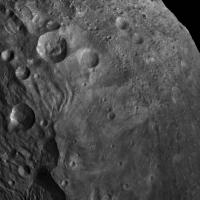
And today picture resized 400% and gamma corection for "best look"
From TIFF.
Source: http://photojournal.jpl.nasa.gov/catalog/PIA14698 http://dawn.jpl.nasa.gov/multimedia/imageo...p?date=20110911 -------------------- Adam Hurcewicz from Poland
|
|
|
|
|
|
|
Sep 16 2011, 04:52 AM
Post
#3
|
||
|
Member Group: Members Posts: 146 Joined: 31-October 08 Member No.: 4473 |
QUOTE (Adam Hurcewicz @ Sep 12 2011, 02:52 AM)  And today picture resized 400% and gamma corection for "best look" From TIFF.
Source: http://photojournal.jpl.nasa.gov/catalog/PIA14698 http://dawn.jpl.nasa.gov/multimedia/imageo...p?date=20110911 This picture is starting to show some very fine surface detail and texture. I can see why the science pros are tossing out some of their early hypotheses. There is more than enough weird stuff not like anything else seen to make me want to shut up theorizing until I've had a closer look. Some of the topics for thought on the shaping of Vesta... Extreme seismic phenomenon from South Pole impact. Contributor to Equatorial grooves? To smaller terrain shapes? Extreme-but-transient electromagnetic phenomenon. (Impact, CME?) Large structurally detailed albedo features relatively independent of surface terrain. Impacts of globs of stuff? Exposed dike/craton forms? Ring collapse onto wobbly Vesta? Unlikely, with many ridge-groove areas non-great-circle. But if the impact sent out heavily-"rayed" debris, could it produce the right terrain on fast-rotating Vesta? So many questions. More than before Dawn arrived... |
|
|
|
|
|
 Phil Stooke HAMO Sep 1 2011, 01:12 PM
 mchan Marc Rayman's latest Dawn Journal on HAMO --
... Sep 1 2011, 08:17 PM DrShank QUOTE (Phil Stooke @ Sep 1 2011, 07:12 AM... Sep 2 2011, 05:55 PM Phil Stooke Thanks, Paul.
Phil Sep 2 2011, 06:00 PM
mchan Marc Rayman's latest Dawn Journal on HAMO --
... Sep 1 2011, 08:17 PM DrShank QUOTE (Phil Stooke @ Sep 1 2011, 07:12 AM... Sep 2 2011, 05:55 PM Phil Stooke Thanks, Paul.
Phil Sep 2 2011, 06:00 PM
 dilo Thanks for updates, Paul!
Here below the updat... Sep 3 2011, 07:19 AM DrShank QUOTE (dilo @ Sep 3 2011, 01:19 AM) Thank... Sep 3 2011, 04:29 PM dilo I made by myself using MYSTIC simulator info from ... Sep 3 2011, 05:42 PM Sarunia First Message: Hello everybody
Answering dilo:
... Sep 3 2011, 08:58 PM DrShank QUOTE (Sarunia @ Sep 3 2011, 02:58 PM) Fi... Sep 4 2011, 11:36 PM dilo QUOTE (Sarunia @ Sep 3 2011, 08:58 PM) ..... Sep 5 2011, 11:10 AM Phil Stooke Great pictures recently - not from HAMO yet or eve... Sep 5 2011, 03:03 PM Gsnorgathon Dare I say those lobate margins look like flow fea... Sep 5 2011, 03:36 PM Bill Harris > I'm especially interested at the moment i... Sep 6 2011, 10:22 AM DrShank QUOTE (Bill Harris @ Sep 6 2011, 04:22 AM... Sep 6 2011, 01:19 PM Phil Stooke The eccentric fill may be a result of a local slop... Sep 6 2011, 01:49 PM Bill Harris I considered this an, uh, occipital illusion, and ... Sep 6 2011, 03:05 PM Phil Stooke Several of the recent images can be joined to make... Sep 6 2011, 03:46 PM pablogm1024 QUOTE (Phil Stooke @ Sep 6 2011, 03:46 PM... Sep 7 2011, 06:18 PM nprev ...again. (That's why I've been hooked on ... Sep 8 2011, 04:06 AM Phil Stooke Latest picture of the day - an unusual hill:
htt... Sep 8 2011, 05:15 PM PDP8E Assuming the magma chamber is not uranium powered ... Sep 8 2011, 05:28 PM Phil Stooke A whale-shaped moon!
Vesta is well known for ... Sep 8 2011, 06:36 PM dilo Dawn is approaaching to final orbit through a comp... Sep 9 2011, 06:31 AM Tunglere A glimpse of Vesta in colour!
http://photojour... Sep 10 2011, 04:49 PM dilo More and more closer to final orbit... Sep 14 2011, 12:32 PM dilo Simulator didn't update images in the last 14 ... Sep 15 2011, 06:19 PM djellison Have you tried sending them a friendly email rathe... Sep 15 2011, 06:27 PM dilo Good suggestion, Dough (I was hoping someone here ... Sep 15 2011, 08:13 PM Bill Harris Yes, we'ev got a lot of puzzle-pieces to fit a... Sep 16 2011, 11:47 AM Phil Stooke Many great new pics at the Photojournal today incl... Sep 16 2011, 02:54 PM Phil Stooke This is a montage of frames from the shape model r... Sep 16 2011, 03:39 PM stevesliva Also cataloged here:
http://dawn.jpl.nasa.gov/mult... Sep 16 2011, 05:55 PM DrShank QUOTE (stevesliva @ Sep 16 2011, 12:55 PM... Sep 16 2011, 07:19 PM Phil Stooke http://www.dawn.mps.mpg.de/index.php?id=17...de9d3... Sep 17 2011, 11:49 PM Juramike Love it! Sooo cool! How about that massiv... Sep 18 2011, 12:14 PM pablogm1024 QUOTE (Juramike @ Sep 18 2011, 01:14 PM) ... Sep 21 2011, 04:34 PM Phil Stooke Approximate fit to the previous map.
Phil
Sep 18 2011, 03:47 PM alan Could this be a basin?
Sep 19 2011, 04:12 PM Gsnorgathon It's clearly a basin. The trick is, what cause... Sep 19 2011, 05:02 PM dilo I had an interesting and very pleasant communicati... Sep 19 2011, 08:59 PM Phil Stooke Yes! It's very interesting to overlay the... Sep 21 2011, 05:24 PM belleraphon1 In Universe Today is an interview with Prof. Chris... Sep 21 2011, 06:41 PM belleraphon1 GSA meeting 10/12/11... DAWN session
Dawn at Vest... Sep 21 2011, 06:53 PM Paolo QUOTE (belleraphon1 @ Sep 21 2011, 08:53 ... Sep 22 2011, 04:18 PM volcanopele It makes some sense. The reason you think everyth... Sep 22 2011, 05:22 PM Juramike And along a similar vein (!):
QUOTE Color d... Sep 22 2011, 05:11 PM Phil Stooke When you say Rheasilvia, do you mean Rheasilvia or... Sep 22 2011, 08:37 PM volcanopele Hey, I am just trying to get used to the name... Sep 22 2011, 09:27 PM Phil Stooke Well, you're getting lots of experience!
... Sep 22 2011, 09:32 PM stevesliva I wouldn't mind if you called it Rheasliva.
I... Sep 23 2011, 07:24 AM Phil Stooke A little thing I've been playing with... the r... Sep 23 2011, 05:45 PM dilo In the last 5 days, Dawn didn't use his engine... Sep 23 2011, 10:01 PM Greg Hullender QUOTE (dilo @ Sep 23 2011, 03:01 PM) In t... Sep 24 2011, 03:38 AM DFinfrock QUOTE (Phil Stooke @ Sep 23 2011, 06:45 P... Sep 23 2011, 10:42 PM monty python Just looking at Phil's picture.
What if a rap... Sep 24 2011, 07:14 AM tanjent Indeed, Vesta's midsection does look as if it ... Sep 24 2011, 07:59 AM bk_2 QUOTE (tanjent @ Sep 24 2011, 08:59 AM) I... Sep 29 2011, 01:53 AM Explorer1 Latest journal entry shows that Rheasilvia is inde... Sep 29 2011, 06:40 PM ilbasso My total ignorance of geology is showing, but I co... Sep 29 2011, 10:02 PM Gsnorgathon QUOTE (ilbasso @ Sep 29 2011, 02:02 PM) M... Sep 30 2011, 04:08 PM SolarSystemRubble Yes, here's the latest Dawn journal:
http://d... Sep 30 2011, 12:10 AM machi Two new stereoscopic images from my blog:
South po... Sep 30 2011, 04:23 PM dilo QUOTE (machi @ Sep 30 2011, 04:23 PM) Two... Oct 1 2011, 12:57 PM antipode Wow, what an extraordinary structure that has turn... Oct 1 2011, 01:06 PM Hungry4info Is this the first image from HAMO?
Looks splendid ... Oct 2 2011, 12:47 AM volcanopele This image was released yesterday:
http://dawn.jp... Oct 2 2011, 01:48 AM dilo Indeed, while yesterday's published image was ... Oct 2 2011, 06:53 AM dilo One question: do someone knows updated Vesta size ... Oct 3 2011, 01:47 PM ElkGroveDan QUOTE (dilo @ Oct 3 2011, 06:47 AM) One q... Oct 3 2011, 05:10 PM belleraphon1 From the EPSC-DPS Joint Meeting 2011 ..
Media rele... Oct 3 2011, 04:09 PM volcanopele As mentioned in the press release, several names h... Oct 3 2011, 04:59 PM Phil Stooke ... or part of the answer. She doesn't give t... Oct 3 2011, 06:16 PM dilo Thanks for highlight, ElkGroveDan! And perfect... Oct 3 2011, 08:55 PM belleraphon1 The big thing to me was Dr. Russell's mention ... Oct 3 2011, 11:34 PM dilo Update with zoomed scale on last 3 weeks:
Height ... Oct 4 2011, 08:33 PM MarkG Full inline quote - with image - removed - ADMIN
... Oct 7 2011, 04:12 AM stevesliva Today's image of the day is pretty fun to look... Oct 9 2011, 05:54 PM monty python Yea. It looks like there is a darker (older) laye... Oct 10 2011, 05:26 AM Juramike Low gravity small body dynamics? The debris flyin... Oct 10 2011, 01:34 PM alan This paper written a few months before Dawn reache... Oct 11 2011, 04:36 PM stevesliva 3-D perspective view of the south:
http://dawn.jpl... Oct 11 2011, 05:35 PM charborob QUOTE (stevesliva @ Oct 11 2011, 01:35 PM... Oct 11 2011, 05:53 PM chuckclark QUOTE (charborob @ Oct 11 2011, 12:53 PM)... Oct 11 2011, 06:02 PM charborob QUOTE (chuckclark @ Oct 11 2011, 02:02 PM... Oct 11 2011, 08:54 PM ngunn What a mess. Scientific disinformation in a place ... Oct 11 2011, 10:22 PM stevesliva I would hazard a guess that projecting onto an pla... Oct 12 2011, 03:24 AM dilo QUOTE (ngunn @ Oct 11 2011, 10:22 PM) Wha... Oct 12 2011, 04:10 AM chuckclark QUOTE (dilo @ Oct 11 2011, 11:10 PM) Thin... Oct 12 2011, 10:55 AM Phil Stooke Once you have a DEM you can project it any way you... Oct 12 2011, 01:15 PM stevesliva Slew of new stuff:
http://dawn.jpl.nasa.gov/featur... Oct 14 2011, 12:09 AM Phil Stooke The latest image releases at the Dawn site are muc... Oct 17 2011, 06:27 PM dilo QUOTE (Phil Stooke @ Oct 17 2011, 06:27 P... Oct 18 2011, 05:30 AM pablogm1024 Any opinions on the strange half-craters on the re... Oct 22 2011, 08:01 PM Gladstoner . Oct 24 2011, 08:50 AM stevesliva Sure looks like a trough between the two. Oct 22 2011, 09:57 PM JTN Railway embankment between the two craters?
(Broa... Oct 22 2011, 11:55 PM monty python It's strange isn't it. I see areas on ves... Oct 23 2011, 09:14 AM bk_2 The differing depth of loose ejecta may come into ... Oct 24 2011, 07:59 AM
dilo Thanks for updates, Paul!
Here below the updat... Sep 3 2011, 07:19 AM DrShank QUOTE (dilo @ Sep 3 2011, 01:19 AM) Thank... Sep 3 2011, 04:29 PM dilo I made by myself using MYSTIC simulator info from ... Sep 3 2011, 05:42 PM Sarunia First Message: Hello everybody
Answering dilo:
... Sep 3 2011, 08:58 PM DrShank QUOTE (Sarunia @ Sep 3 2011, 02:58 PM) Fi... Sep 4 2011, 11:36 PM dilo QUOTE (Sarunia @ Sep 3 2011, 08:58 PM) ..... Sep 5 2011, 11:10 AM Phil Stooke Great pictures recently - not from HAMO yet or eve... Sep 5 2011, 03:03 PM Gsnorgathon Dare I say those lobate margins look like flow fea... Sep 5 2011, 03:36 PM Bill Harris > I'm especially interested at the moment i... Sep 6 2011, 10:22 AM DrShank QUOTE (Bill Harris @ Sep 6 2011, 04:22 AM... Sep 6 2011, 01:19 PM Phil Stooke The eccentric fill may be a result of a local slop... Sep 6 2011, 01:49 PM Bill Harris I considered this an, uh, occipital illusion, and ... Sep 6 2011, 03:05 PM Phil Stooke Several of the recent images can be joined to make... Sep 6 2011, 03:46 PM pablogm1024 QUOTE (Phil Stooke @ Sep 6 2011, 03:46 PM... Sep 7 2011, 06:18 PM nprev ...again. (That's why I've been hooked on ... Sep 8 2011, 04:06 AM Phil Stooke Latest picture of the day - an unusual hill:
htt... Sep 8 2011, 05:15 PM PDP8E Assuming the magma chamber is not uranium powered ... Sep 8 2011, 05:28 PM Phil Stooke A whale-shaped moon!
Vesta is well known for ... Sep 8 2011, 06:36 PM dilo Dawn is approaaching to final orbit through a comp... Sep 9 2011, 06:31 AM Tunglere A glimpse of Vesta in colour!
http://photojour... Sep 10 2011, 04:49 PM dilo More and more closer to final orbit... Sep 14 2011, 12:32 PM dilo Simulator didn't update images in the last 14 ... Sep 15 2011, 06:19 PM djellison Have you tried sending them a friendly email rathe... Sep 15 2011, 06:27 PM dilo Good suggestion, Dough (I was hoping someone here ... Sep 15 2011, 08:13 PM Bill Harris Yes, we'ev got a lot of puzzle-pieces to fit a... Sep 16 2011, 11:47 AM Phil Stooke Many great new pics at the Photojournal today incl... Sep 16 2011, 02:54 PM Phil Stooke This is a montage of frames from the shape model r... Sep 16 2011, 03:39 PM stevesliva Also cataloged here:
http://dawn.jpl.nasa.gov/mult... Sep 16 2011, 05:55 PM DrShank QUOTE (stevesliva @ Sep 16 2011, 12:55 PM... Sep 16 2011, 07:19 PM Phil Stooke http://www.dawn.mps.mpg.de/index.php?id=17...de9d3... Sep 17 2011, 11:49 PM Juramike Love it! Sooo cool! How about that massiv... Sep 18 2011, 12:14 PM pablogm1024 QUOTE (Juramike @ Sep 18 2011, 01:14 PM) ... Sep 21 2011, 04:34 PM Phil Stooke Approximate fit to the previous map.
Phil
Sep 18 2011, 03:47 PM alan Could this be a basin?
Sep 19 2011, 04:12 PM Gsnorgathon It's clearly a basin. The trick is, what cause... Sep 19 2011, 05:02 PM dilo I had an interesting and very pleasant communicati... Sep 19 2011, 08:59 PM Phil Stooke Yes! It's very interesting to overlay the... Sep 21 2011, 05:24 PM belleraphon1 In Universe Today is an interview with Prof. Chris... Sep 21 2011, 06:41 PM belleraphon1 GSA meeting 10/12/11... DAWN session
Dawn at Vest... Sep 21 2011, 06:53 PM Paolo QUOTE (belleraphon1 @ Sep 21 2011, 08:53 ... Sep 22 2011, 04:18 PM volcanopele It makes some sense. The reason you think everyth... Sep 22 2011, 05:22 PM Juramike And along a similar vein (!):
QUOTE Color d... Sep 22 2011, 05:11 PM Phil Stooke When you say Rheasilvia, do you mean Rheasilvia or... Sep 22 2011, 08:37 PM volcanopele Hey, I am just trying to get used to the name... Sep 22 2011, 09:27 PM Phil Stooke Well, you're getting lots of experience!
... Sep 22 2011, 09:32 PM stevesliva I wouldn't mind if you called it Rheasliva.
I... Sep 23 2011, 07:24 AM Phil Stooke A little thing I've been playing with... the r... Sep 23 2011, 05:45 PM dilo In the last 5 days, Dawn didn't use his engine... Sep 23 2011, 10:01 PM Greg Hullender QUOTE (dilo @ Sep 23 2011, 03:01 PM) In t... Sep 24 2011, 03:38 AM DFinfrock QUOTE (Phil Stooke @ Sep 23 2011, 06:45 P... Sep 23 2011, 10:42 PM monty python Just looking at Phil's picture.
What if a rap... Sep 24 2011, 07:14 AM tanjent Indeed, Vesta's midsection does look as if it ... Sep 24 2011, 07:59 AM bk_2 QUOTE (tanjent @ Sep 24 2011, 08:59 AM) I... Sep 29 2011, 01:53 AM Explorer1 Latest journal entry shows that Rheasilvia is inde... Sep 29 2011, 06:40 PM ilbasso My total ignorance of geology is showing, but I co... Sep 29 2011, 10:02 PM Gsnorgathon QUOTE (ilbasso @ Sep 29 2011, 02:02 PM) M... Sep 30 2011, 04:08 PM SolarSystemRubble Yes, here's the latest Dawn journal:
http://d... Sep 30 2011, 12:10 AM machi Two new stereoscopic images from my blog:
South po... Sep 30 2011, 04:23 PM dilo QUOTE (machi @ Sep 30 2011, 04:23 PM) Two... Oct 1 2011, 12:57 PM antipode Wow, what an extraordinary structure that has turn... Oct 1 2011, 01:06 PM Hungry4info Is this the first image from HAMO?
Looks splendid ... Oct 2 2011, 12:47 AM volcanopele This image was released yesterday:
http://dawn.jp... Oct 2 2011, 01:48 AM dilo Indeed, while yesterday's published image was ... Oct 2 2011, 06:53 AM dilo One question: do someone knows updated Vesta size ... Oct 3 2011, 01:47 PM ElkGroveDan QUOTE (dilo @ Oct 3 2011, 06:47 AM) One q... Oct 3 2011, 05:10 PM belleraphon1 From the EPSC-DPS Joint Meeting 2011 ..
Media rele... Oct 3 2011, 04:09 PM volcanopele As mentioned in the press release, several names h... Oct 3 2011, 04:59 PM Phil Stooke ... or part of the answer. She doesn't give t... Oct 3 2011, 06:16 PM dilo Thanks for highlight, ElkGroveDan! And perfect... Oct 3 2011, 08:55 PM belleraphon1 The big thing to me was Dr. Russell's mention ... Oct 3 2011, 11:34 PM dilo Update with zoomed scale on last 3 weeks:
Height ... Oct 4 2011, 08:33 PM MarkG Full inline quote - with image - removed - ADMIN
... Oct 7 2011, 04:12 AM stevesliva Today's image of the day is pretty fun to look... Oct 9 2011, 05:54 PM monty python Yea. It looks like there is a darker (older) laye... Oct 10 2011, 05:26 AM Juramike Low gravity small body dynamics? The debris flyin... Oct 10 2011, 01:34 PM alan This paper written a few months before Dawn reache... Oct 11 2011, 04:36 PM stevesliva 3-D perspective view of the south:
http://dawn.jpl... Oct 11 2011, 05:35 PM charborob QUOTE (stevesliva @ Oct 11 2011, 01:35 PM... Oct 11 2011, 05:53 PM chuckclark QUOTE (charborob @ Oct 11 2011, 12:53 PM)... Oct 11 2011, 06:02 PM charborob QUOTE (chuckclark @ Oct 11 2011, 02:02 PM... Oct 11 2011, 08:54 PM ngunn What a mess. Scientific disinformation in a place ... Oct 11 2011, 10:22 PM stevesliva I would hazard a guess that projecting onto an pla... Oct 12 2011, 03:24 AM dilo QUOTE (ngunn @ Oct 11 2011, 10:22 PM) Wha... Oct 12 2011, 04:10 AM chuckclark QUOTE (dilo @ Oct 11 2011, 11:10 PM) Thin... Oct 12 2011, 10:55 AM Phil Stooke Once you have a DEM you can project it any way you... Oct 12 2011, 01:15 PM stevesliva Slew of new stuff:
http://dawn.jpl.nasa.gov/featur... Oct 14 2011, 12:09 AM Phil Stooke The latest image releases at the Dawn site are muc... Oct 17 2011, 06:27 PM dilo QUOTE (Phil Stooke @ Oct 17 2011, 06:27 P... Oct 18 2011, 05:30 AM pablogm1024 Any opinions on the strange half-craters on the re... Oct 22 2011, 08:01 PM Gladstoner . Oct 24 2011, 08:50 AM stevesliva Sure looks like a trough between the two. Oct 22 2011, 09:57 PM JTN Railway embankment between the two craters?
(Broa... Oct 22 2011, 11:55 PM monty python It's strange isn't it. I see areas on ves... Oct 23 2011, 09:14 AM bk_2 The differing depth of loose ejecta may come into ... Oct 24 2011, 07:59 AM |

|
Lo-Fi Version | Time is now: 26th September 2024 - 12:41 PM |
|
RULES AND GUIDELINES Please read the Forum Rules and Guidelines before posting. IMAGE COPYRIGHT |
OPINIONS AND MODERATION Opinions expressed on UnmannedSpaceflight.com are those of the individual posters and do not necessarily reflect the opinions of UnmannedSpaceflight.com or The Planetary Society. The all-volunteer UnmannedSpaceflight.com moderation team is wholly independent of The Planetary Society. The Planetary Society has no influence over decisions made by the UnmannedSpaceflight.com moderators. |
SUPPORT THE FORUM Unmannedspaceflight.com is funded by the Planetary Society. Please consider supporting our work and many other projects by donating to the Society or becoming a member. |
|