Cape York - Shoemaker Ridge and the NE traverse, Starting sol 2735 |

Cape York - Shoemaker Ridge and the NE traverse, Starting sol 2735 |
 Oct 4 2011, 12:20 PM Oct 4 2011, 12:20 PM
Post
#1
|
||
 The Poet Dude  Group: Moderator Posts: 5551 Joined: 15-March 04 From: Kendal, Cumbria, UK Member No.: 60 |
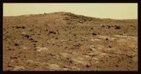
Oppy's next destination - the Shoemaker Ridge...
(3D version here http://roadtoendeavour.files.wordpress.com/2011/10/sr-3d.jpg ) Some more height...surrounded by lots of gorgeous rocks...view right across Endeavour... our first view too, probably, of the Promised Land in the centre of Cape York where the phylosillicates are waiting to be found... Go get 'em, Oppy!  Edit: looks like Oppy's on the move... http://qt.exploratorium.edu/mars/opportuni...84P1211L0M1.JPG -------------------- |
|
 |
 
|
|
 |
|
Oct 27 2011, 10:29 AM
Post
#2
|
|
 Member Group: Members Posts: 593 Joined: 20-April 05 Member No.: 279 |
Love that data, Pete.
Is there any chance you could combine the slope and aspect results? Maybe run this: angle = ACOS((sin(slope)*cos(aspect)*sin(sol))+(cos(slope)*cos(sol))) Where: slope is measured in radians aspect in radians from north, going clockwise sol is 0.576 in radians (90-57 degrees, from the axial tilt and rover latitude) ...to produce a range of angles from 0 to PI to determine the best (angle = 0) attitude for the rover's panels based on slope and aspect for the midwinter noon. Andy EDIT: sol is 0.471 in radians (27 degrees - being the winter axial tilt and rover's latitude of 2 degrees south). Thanks Fred! |
|
|
|
|
Oct 27 2011, 03:06 PM
Post
#3
|
|
 Member Group: Members Posts: 267 Joined: 5-February 06 Member No.: 675 |
QUOTE (AndyG @ Oct 27 2011, 05:29 AM)  Love that data, Pete. Is there any chance you could combine the slope and aspect results? Second Andy's thanks for the excellent presentation, but agree with him on the desirability of combining slope and aspect data. My choice would be to keep your hue based aspect information, but encode the slope as saturation, with increasing slope indicated by increased saturation. It would provide a fairly intuitive presentation. Can anyone suggest an easy way to do that? SteveM |
|
|
|
 Stu Cape York - Shoemaker Ridge and the NE traverse Oct 4 2011, 12:20 PM
 brellis My mind's eye has been pretty set on the view ... Oct 23 2011, 12:02 AM
 ElkGroveDan QUOTE (brellis @ Oct 22 2011, 05:02 PM) E... Oct 23 2011, 02:09 PM Oersted To help rover driver Scott (and the rest of us) vi... Oct 23 2011, 10:47 AM ngunn QUOTE (Oersted @ Oct 23 2011, 11:47 AM) E... Oct 23 2011, 02:43 PM Oersted QUOTE (ngunn @ Oct 23 2011, 04:43 PM) Gre... Oct 23 2011, 08:12 PM Stu Great idea! You should give it a go! Oct 23 2011, 11:17 AM Oersted Oh, that would be way above my feeble skills... - ... Oct 23 2011, 11:37 AM Stu That's the way I used to think, too, but gave ... Oct 23 2011, 12:13 PM mhoward A couple stereo pairs of Fairview. Oct 23 2011, 07:37 PM ngunn True, but I think we'd get used to it. One che... Oct 23 2011, 09:23 PM Bill Harris QUOTE (MHoward)iPhone/iPod Touch with a my3D, the ... Oct 23 2011, 09:37 PM mhoward QUOTE (Bill Harris @ Oct 23 2011, 03:37 P... Oct 23 2011, 10:46 PM Bill Harris Simple-- in an image editor, swap the images left-... Oct 24 2011, 12:03 AM PDP8E Here is my first crude attempt at putting the Eiff... Oct 24 2011, 02:04 AM walfy The winds of Mars sandblast the rocks in such a wa... Oct 24 2011, 03:15 AM Oersted QUOTE (PDP8E @ Oct 24 2011, 04:04 AM) Her... Oct 24 2011, 11:46 AM ElkGroveDan Its probably not so much lower gravity causing the... Oct 24 2011, 03:48 AM CosmicRocker QUOTE (Stu @ Oct 22 2011, 10:06 AM) No ve... Oct 24 2011, 04:12 AM Bill Harris Just snagged yesterday's 18:35 data upload. N... Oct 24 2011, 08:08 AM Tesheiner According to the "telemetry", this last ... Oct 24 2011, 08:35 AM Bill Harris ...but we've been moving along the west (left)... Oct 24 2011, 08:59 AM Stu 3D view of latest panorama... loving those hills..... Oct 24 2011, 10:03 AM Stu Now I couldn't resist giving that a go...... Oct 24 2011, 12:28 PM Oersted QUOTE (Stu @ Oct 24 2011, 02:28 PM) Now I... Oct 24 2011, 03:30 PM mhoward 360x90 anaglyph Navcam panorama centered on north ... Oct 24 2011, 03:06 PM Jam Butty 'Fairview' sol 2753
Pancam flicker gif L25... Oct 24 2011, 03:31 PM mhoward Pancam "drive direction" anaglyph sol 27... Oct 24 2011, 03:33 PM marsophile What are Oppy's chances of getting a "cle... Oct 24 2011, 03:40 PM atomoid QUOTE (marsophile @ Oct 24 2011, 08:40 AM... Oct 24 2011, 09:37 PM Phil Stooke Circular version of mhowards's anaglyph... I f... Oct 24 2011, 04:14 PM Bill Harris Neat, Phil. I suspected that the bump to the due... Oct 24 2011, 04:57 PM Tesheiner QUOTE (Bill Harris @ Oct 24 2011, 06:57 P... Oct 24 2011, 07:00 PM mhoward I guess I'll go back to posting left, right an... Oct 24 2011, 05:29 PM Bill Harris No telling at this point about that "NW Bump... Oct 24 2011, 09:40 PM brellis Rereading Stu's latest interview with Scott Ma... Oct 25 2011, 12:29 AM walfy Oppy's tracks nicely framed today, with the dr... Oct 25 2011, 05:44 PM mhoward Here's a my3D stereo pair of the Pancam foregr... Oct 25 2011, 08:52 PM atomoid nice stereo pairs! (above and in recent posts)... Oct 25 2011, 11:10 PM marsophile QUOTE (atomoid @ Oct 25 2011, 04:10 PM) .... Oct 26 2011, 12:01 AM Gladstoner . Oct 26 2011, 07:41 PM walfy QUOTE (Gladstoner @ Oct 26 2011, 11:41 AM... Oct 26 2011, 08:45 PM fredk It is a shame that that 3D format has the wrong or... Oct 26 2011, 12:23 AM Jam Butty QUOTE (fredk @ Oct 26 2011, 01:23 AM) But... Oct 26 2011, 01:08 AM Bill Harris There are now images of the following sites on Sho... Oct 26 2011, 05:39 PM atomoid thanks, i tried and got it to work (yes, by *not* ... Oct 26 2011, 11:12 PM PDP8E This is one of the best NavCam shots ever taken by... Oct 27 2011, 02:45 AM walfy QUOTE (PDP8E @ Oct 26 2011, 06:45 PM) ...... Oct 27 2011, 04:48 AM fredk QUOTE (walfy @ Oct 27 2011, 05:48 AM) Unf... Oct 27 2011, 08:50 PM pgrindrod I've been meaning to do this for a while, but ... Oct 27 2011, 05:04 AM CosmicRocker Very nice. Thank you. Oct 27 2011, 05:28 AM AndyG Hi Steve,
My post #250 would produce one number f... Oct 27 2011, 03:57 PM ElkGroveDan QUOTE (SteveM @ Oct 27 2011, 08:06 AM) Ca... Oct 27 2011, 11:21 PM Fran Ontanaya @SteveM: On GIMP, create a gradient with whatever ... Oct 28 2011, 06:07 AM ngunn Great maps! I'm a little puzzled by the sl... Oct 27 2011, 12:01 PM pgrindrod Ah, the perils of posting on UMSF when jetlagged -... Oct 27 2011, 02:33 PM Stu "New Consort"...
I love staring into ... Oct 27 2011, 02:52 PM mhoward Sol 2756 360x90 Navcam panorama
left right anag... Oct 27 2011, 03:43 PM ngunn How about just mapping the northward component of ... Oct 27 2011, 05:29 PM fredk Thanks a lot for those maps, Pete. I agree a simp... Oct 27 2011, 07:07 PM mhoward Here's a my3D stereo pair for "New Consor... Oct 27 2011, 08:32 PM Nix I remember registering the color info only from th... Oct 27 2011, 08:45 PM Nix stereo-rightframecolor-stolen-from-leftframe.. Oct 27 2011, 09:18 PM mhoward QUOTE (Nix @ Oct 27 2011, 03:18 PM) stere... Oct 27 2011, 11:08 PM Nix QUOTE (mhoward @ Oct 28 2011, 01:08 AM) N... Oct 27 2011, 11:37 PM Phil Stooke mhoward's latest pan in circular format...
P... Oct 28 2011, 12:20 AM Bill Harris Very good, Phil-- I was hoping you would post one ... Oct 28 2011, 01:41 AM pgrindrod Hmm, does this help? I think I've managed to w... Oct 28 2011, 04:34 AM AndyG QUOTE (pgrindrod @ Oct 28 2011, 05:34 AM)... Oct 28 2011, 10:50 AM fredk QUOTE (pgrindrod @ Oct 28 2011, 05:34 AM)... Oct 28 2011, 06:35 PM CosmicRocker QUOTE (fredk @ Oct 27 2011, 02:07 PM) ...... Oct 28 2011, 04:43 AM djellison QUOTE (CosmicRocker @ Oct 27 2011, 09:43 ... Oct 28 2011, 07:03 AM Matt Lenda QUOTE (CosmicRocker @ Oct 27 2011, 09:43 ... Oct 28 2011, 08:03 PM marsophile QUOTE (Matt Lenda @ Oct 28 2011, 01:03 PM... Oct 29 2011, 12:01 AM ngunn Looks like we're on the top: http://qt.explora... Oct 28 2011, 07:48 AM Tesheiner QUOTE (ngunn @ Oct 28 2011, 09:48 AM) Loo... Oct 28 2011, 09:21 AM Stu Thatta girl, Oppy!
Clearer view to the nor... Oct 28 2011, 08:22 AM ngunn Ah - a chance to examine the light-toned 'flan... Oct 28 2011, 10:55 AM Oersted Would this be the highest elevation yet reached by... Oct 28 2011, 02:32 PM centsworth_II QUOTE (Oersted @ Oct 28 2011, 10:32 AM) W... Oct 28 2011, 04:06 PM Bill Harris Since Oppy is in the area underlain by the geologi... Oct 28 2011, 03:14 PM Phil Stooke "Would this be the highest elevation yet reac... Oct 28 2011, 04:01 PM mhoward Sol 2758 Navcam anaglyph panorama. I'll update... Oct 28 2011, 04:13 PM stevesliva The latest power numbers aren't great. Ugly t... Oct 28 2011, 04:44 PM Floyd How are you missing (as Doug said) that if you onl... Oct 29 2011, 12:38 AM Matt Lenda QUOTE (Floyd @ Oct 28 2011, 05:38 PM) How... Oct 29 2011, 07:57 PM fredk I think the concern was more just drivability, rat... Oct 29 2011, 11:11 PM fredk Yeah, I think "north component of slope... Oct 29 2011, 01:01 AM AndyG QUOTE (fredk @ Oct 29 2011, 01:01 AM) And... Oct 30 2011, 10:12 AM marsophile Yes, a deviation in the East/West direction is les... Oct 29 2011, 05:45 AM Stu It's been a long road... getting from there to... Oct 29 2011, 11:27 AM mhoward Sol 2758 Pancam anaglyph Oct 29 2011, 03:58 PM Bill Harris And here we are. We're there.
This is a pano... Oct 30 2011, 08:44 AM Tesheiner Just posted an update on the route map thread. Loo... Oct 30 2011, 09:27 AM Stu Definitely rubble at Oppy's feet now...
By ... Oct 30 2011, 01:10 PM fredk If anyone's curious why we've drifted to t... Oct 30 2011, 04:35 PM mhoward QUOTE (fredk @ Oct 30 2011, 10:35 AM) on ... Oct 30 2011, 04:45 PM Greg Hullender Since Opportunity is just two degrees from the equ... Oct 30 2011, 06:46 PM fredk People have been talking about aphelion - see this... Oct 30 2011, 08:20 PM
ElkGroveDan QUOTE (brellis @ Oct 22 2011, 05:02 PM) E... Oct 23 2011, 02:09 PM Oersted To help rover driver Scott (and the rest of us) vi... Oct 23 2011, 10:47 AM ngunn QUOTE (Oersted @ Oct 23 2011, 11:47 AM) E... Oct 23 2011, 02:43 PM Oersted QUOTE (ngunn @ Oct 23 2011, 04:43 PM) Gre... Oct 23 2011, 08:12 PM Stu Great idea! You should give it a go! Oct 23 2011, 11:17 AM Oersted Oh, that would be way above my feeble skills... - ... Oct 23 2011, 11:37 AM Stu That's the way I used to think, too, but gave ... Oct 23 2011, 12:13 PM mhoward A couple stereo pairs of Fairview. Oct 23 2011, 07:37 PM ngunn True, but I think we'd get used to it. One che... Oct 23 2011, 09:23 PM Bill Harris QUOTE (MHoward)iPhone/iPod Touch with a my3D, the ... Oct 23 2011, 09:37 PM mhoward QUOTE (Bill Harris @ Oct 23 2011, 03:37 P... Oct 23 2011, 10:46 PM Bill Harris Simple-- in an image editor, swap the images left-... Oct 24 2011, 12:03 AM PDP8E Here is my first crude attempt at putting the Eiff... Oct 24 2011, 02:04 AM walfy The winds of Mars sandblast the rocks in such a wa... Oct 24 2011, 03:15 AM Oersted QUOTE (PDP8E @ Oct 24 2011, 04:04 AM) Her... Oct 24 2011, 11:46 AM ElkGroveDan Its probably not so much lower gravity causing the... Oct 24 2011, 03:48 AM CosmicRocker QUOTE (Stu @ Oct 22 2011, 10:06 AM) No ve... Oct 24 2011, 04:12 AM Bill Harris Just snagged yesterday's 18:35 data upload. N... Oct 24 2011, 08:08 AM Tesheiner According to the "telemetry", this last ... Oct 24 2011, 08:35 AM Bill Harris ...but we've been moving along the west (left)... Oct 24 2011, 08:59 AM Stu 3D view of latest panorama... loving those hills..... Oct 24 2011, 10:03 AM Stu Now I couldn't resist giving that a go...... Oct 24 2011, 12:28 PM Oersted QUOTE (Stu @ Oct 24 2011, 02:28 PM) Now I... Oct 24 2011, 03:30 PM mhoward 360x90 anaglyph Navcam panorama centered on north ... Oct 24 2011, 03:06 PM Jam Butty 'Fairview' sol 2753
Pancam flicker gif L25... Oct 24 2011, 03:31 PM mhoward Pancam "drive direction" anaglyph sol 27... Oct 24 2011, 03:33 PM marsophile What are Oppy's chances of getting a "cle... Oct 24 2011, 03:40 PM atomoid QUOTE (marsophile @ Oct 24 2011, 08:40 AM... Oct 24 2011, 09:37 PM Phil Stooke Circular version of mhowards's anaglyph... I f... Oct 24 2011, 04:14 PM Bill Harris Neat, Phil. I suspected that the bump to the due... Oct 24 2011, 04:57 PM Tesheiner QUOTE (Bill Harris @ Oct 24 2011, 06:57 P... Oct 24 2011, 07:00 PM mhoward I guess I'll go back to posting left, right an... Oct 24 2011, 05:29 PM Bill Harris No telling at this point about that "NW Bump... Oct 24 2011, 09:40 PM brellis Rereading Stu's latest interview with Scott Ma... Oct 25 2011, 12:29 AM walfy Oppy's tracks nicely framed today, with the dr... Oct 25 2011, 05:44 PM mhoward Here's a my3D stereo pair of the Pancam foregr... Oct 25 2011, 08:52 PM atomoid nice stereo pairs! (above and in recent posts)... Oct 25 2011, 11:10 PM marsophile QUOTE (atomoid @ Oct 25 2011, 04:10 PM) .... Oct 26 2011, 12:01 AM Gladstoner . Oct 26 2011, 07:41 PM walfy QUOTE (Gladstoner @ Oct 26 2011, 11:41 AM... Oct 26 2011, 08:45 PM fredk It is a shame that that 3D format has the wrong or... Oct 26 2011, 12:23 AM Jam Butty QUOTE (fredk @ Oct 26 2011, 01:23 AM) But... Oct 26 2011, 01:08 AM Bill Harris There are now images of the following sites on Sho... Oct 26 2011, 05:39 PM atomoid thanks, i tried and got it to work (yes, by *not* ... Oct 26 2011, 11:12 PM PDP8E This is one of the best NavCam shots ever taken by... Oct 27 2011, 02:45 AM walfy QUOTE (PDP8E @ Oct 26 2011, 06:45 PM) ...... Oct 27 2011, 04:48 AM fredk QUOTE (walfy @ Oct 27 2011, 05:48 AM) Unf... Oct 27 2011, 08:50 PM pgrindrod I've been meaning to do this for a while, but ... Oct 27 2011, 05:04 AM CosmicRocker Very nice. Thank you. Oct 27 2011, 05:28 AM AndyG Hi Steve,
My post #250 would produce one number f... Oct 27 2011, 03:57 PM ElkGroveDan QUOTE (SteveM @ Oct 27 2011, 08:06 AM) Ca... Oct 27 2011, 11:21 PM Fran Ontanaya @SteveM: On GIMP, create a gradient with whatever ... Oct 28 2011, 06:07 AM ngunn Great maps! I'm a little puzzled by the sl... Oct 27 2011, 12:01 PM pgrindrod Ah, the perils of posting on UMSF when jetlagged -... Oct 27 2011, 02:33 PM Stu "New Consort"...
I love staring into ... Oct 27 2011, 02:52 PM mhoward Sol 2756 360x90 Navcam panorama
left right anag... Oct 27 2011, 03:43 PM ngunn How about just mapping the northward component of ... Oct 27 2011, 05:29 PM fredk Thanks a lot for those maps, Pete. I agree a simp... Oct 27 2011, 07:07 PM mhoward Here's a my3D stereo pair for "New Consor... Oct 27 2011, 08:32 PM Nix I remember registering the color info only from th... Oct 27 2011, 08:45 PM Nix stereo-rightframecolor-stolen-from-leftframe.. Oct 27 2011, 09:18 PM mhoward QUOTE (Nix @ Oct 27 2011, 03:18 PM) stere... Oct 27 2011, 11:08 PM Nix QUOTE (mhoward @ Oct 28 2011, 01:08 AM) N... Oct 27 2011, 11:37 PM Phil Stooke mhoward's latest pan in circular format...
P... Oct 28 2011, 12:20 AM Bill Harris Very good, Phil-- I was hoping you would post one ... Oct 28 2011, 01:41 AM pgrindrod Hmm, does this help? I think I've managed to w... Oct 28 2011, 04:34 AM AndyG QUOTE (pgrindrod @ Oct 28 2011, 05:34 AM)... Oct 28 2011, 10:50 AM fredk QUOTE (pgrindrod @ Oct 28 2011, 05:34 AM)... Oct 28 2011, 06:35 PM CosmicRocker QUOTE (fredk @ Oct 27 2011, 02:07 PM) ...... Oct 28 2011, 04:43 AM djellison QUOTE (CosmicRocker @ Oct 27 2011, 09:43 ... Oct 28 2011, 07:03 AM Matt Lenda QUOTE (CosmicRocker @ Oct 27 2011, 09:43 ... Oct 28 2011, 08:03 PM marsophile QUOTE (Matt Lenda @ Oct 28 2011, 01:03 PM... Oct 29 2011, 12:01 AM ngunn Looks like we're on the top: http://qt.explora... Oct 28 2011, 07:48 AM Tesheiner QUOTE (ngunn @ Oct 28 2011, 09:48 AM) Loo... Oct 28 2011, 09:21 AM Stu Thatta girl, Oppy!
Clearer view to the nor... Oct 28 2011, 08:22 AM ngunn Ah - a chance to examine the light-toned 'flan... Oct 28 2011, 10:55 AM Oersted Would this be the highest elevation yet reached by... Oct 28 2011, 02:32 PM centsworth_II QUOTE (Oersted @ Oct 28 2011, 10:32 AM) W... Oct 28 2011, 04:06 PM Bill Harris Since Oppy is in the area underlain by the geologi... Oct 28 2011, 03:14 PM Phil Stooke "Would this be the highest elevation yet reac... Oct 28 2011, 04:01 PM mhoward Sol 2758 Navcam anaglyph panorama. I'll update... Oct 28 2011, 04:13 PM stevesliva The latest power numbers aren't great. Ugly t... Oct 28 2011, 04:44 PM Floyd How are you missing (as Doug said) that if you onl... Oct 29 2011, 12:38 AM Matt Lenda QUOTE (Floyd @ Oct 28 2011, 05:38 PM) How... Oct 29 2011, 07:57 PM fredk I think the concern was more just drivability, rat... Oct 29 2011, 11:11 PM fredk Yeah, I think "north component of slope... Oct 29 2011, 01:01 AM AndyG QUOTE (fredk @ Oct 29 2011, 01:01 AM) And... Oct 30 2011, 10:12 AM marsophile Yes, a deviation in the East/West direction is les... Oct 29 2011, 05:45 AM Stu It's been a long road... getting from there to... Oct 29 2011, 11:27 AM mhoward Sol 2758 Pancam anaglyph Oct 29 2011, 03:58 PM Bill Harris And here we are. We're there.
This is a pano... Oct 30 2011, 08:44 AM Tesheiner Just posted an update on the route map thread. Loo... Oct 30 2011, 09:27 AM Stu Definitely rubble at Oppy's feet now...
By ... Oct 30 2011, 01:10 PM fredk If anyone's curious why we've drifted to t... Oct 30 2011, 04:35 PM mhoward QUOTE (fredk @ Oct 30 2011, 10:35 AM) on ... Oct 30 2011, 04:45 PM Greg Hullender Since Opportunity is just two degrees from the equ... Oct 30 2011, 06:46 PM fredk People have been talking about aphelion - see this... Oct 30 2011, 08:20 PM |

|
Lo-Fi Version | Time is now: 8th June 2024 - 09:59 AM |
|
RULES AND GUIDELINES Please read the Forum Rules and Guidelines before posting. IMAGE COPYRIGHT |
OPINIONS AND MODERATION Opinions expressed on UnmannedSpaceflight.com are those of the individual posters and do not necessarily reflect the opinions of UnmannedSpaceflight.com or The Planetary Society. The all-volunteer UnmannedSpaceflight.com moderation team is wholly independent of The Planetary Society. The Planetary Society has no influence over decisions made by the UnmannedSpaceflight.com moderators. |
SUPPORT THE FORUM Unmannedspaceflight.com is funded by the Planetary Society. Please consider supporting our work and many other projects by donating to the Society or becoming a member. |
|