Map Features Overlays on a Cylindrical Projection |

Map Features Overlays on a Cylindrical Projection |
 Jan 28 2012, 07:25 PM Jan 28 2012, 07:25 PM
Post
#1
|
|
 Senior Member  Group: Members Posts: 1669 Joined: 5-March 05 From: Boulder, CO Member No.: 184 |
Greetings,
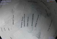
Thought I'd mention I'm starting a mini-project to make map feature overlays for planets and satellites. These are set up on a cylindrical projection so they can be displayed with Science On A Sphere, Celestia, and the like. The key is that text for feature names has to be "pre-distorted" so it looks correct when viewed on a sphere. This is especially important at high latitudes. The overlays are for now in the form of transparent PNG images. So far I've started with Mars and Enceladus. The programming language is IDL, and the lat/lon info for the feature names is from the USGS Map-A-Planet Gazeteer. I'll try to post some results once they are a little better. Enceladus is a special case, since the map I had put together is in planetocentric coordinates, and the feature lat/lons are in planetographic. So a conversion of one or the other would need to be done. Steve -------------------- Steve [ my home page and planetary maps page ]
|
 |
 
|
 |
|
Feb 9 2012, 09:20 PM
Post
#2
|
|
 Director of Galilean Photography Group: Members Posts: 896 Joined: 15-July 04 From: Austin, TX Member No.: 93 |
Someone should make a map with 0 Longitude going down the center instead of the equator. At least then we would have correct perspective on the tiger stripes.

-------------------- Space Enthusiast Richard Hendricks
-- "The engineers, as usual, made a tremendous fuss. Again as usual, they did the job in half the time they had dismissed as being absolutely impossible." --Rescue Party, Arthur C Clarke Mother Nature is the final inspector of all quality. |
|
|
|
|
Feb 14 2012, 04:28 PM
Post
#3
|
||
|
Senior Member Group: Members Posts: 1669 Joined: 5-March 05 From: Boulder, CO Member No.: 184 |
Hendric, yes that would be an interesting presentation, basically rotating the data 90 degrees around the X or Y axis when making the cylindrical projection. The labels should look OK if the map in post #10 is so transformed.
Meanwhile, the general intent with these feature maps is to view them with a program such as Celestia, so one can see the features and labels with a proper perspective hovering over the location of choice. In the case of Celestia the tiger stripes and labels have the correct perspective, though the well-known Celestia polar pinch effect shows up here.
-------------------- Steve [ my home page and planetary maps page ]
|
|
|
|
|
|
 scalbers Map Features Overlays on a Cylindrical Projection Jan 28 2012, 07:25 PM
 scalbers I have now a preliminary map of Mars with the feat... Feb 3 2012, 06:25 PM JohnVV nice but a question on the location of 180 in the ... Feb 3 2012, 10:49 PM djellison That's a debate that's been a part of plan... Feb 3 2012, 11:07 PM scalbers John - I had used the 180 center longitude that cu... Feb 3 2012, 11:10 PM JohnVV as djellison pointed out both are right i was just... Feb 4 2012, 12:40 AM scalbers The funny thing is that the quasi-standard way of ... Feb 4 2012, 12:55 AM scalbers Meanwhile, here's the latest with Enceladus. T... Feb 4 2012, 02:22 AM Phil Stooke Don't get too hung up on the question of havin... Feb 4 2012, 03:45 AM scalbers Here's Enceladus with the longitudes a little ... Feb 4 2012, 05:09 PM john_s The longitude system on Enceladus and the other ic... Feb 8 2012, 05:21 PM
 scalbers QUOTE (john_s @ Feb 8 2012, 05:21 PM) The... Feb 14 2012, 04:33 PM john_s QUOTE (scalbers @ Feb 14 2012, 09:33 AM) ... Feb 14 2012, 05:50 PM scalbers QUOTE (john_s @ Feb 14 2012, 05:50 PM) Th... Feb 14 2012, 06:04 PM Phil Stooke Re: Post 12.
That is called a Transverse Cylindr... Feb 14 2012, 04:37 PM JohnVV QUOTE Very confusing- it took me a long time to so... Feb 14 2012, 05:56 PM scalbers Next one - here's what I have so far for Io sh... Feb 15 2012, 07:37 PM scalbers And here is Europa with features larger than 40km.... Feb 15 2012, 08:47 PM scalbers And back at Saturn, here are the Mimas features (a... Feb 15 2012, 09:18 PM scalbers Here's Iapetus, with a 5 degree shift that app... Feb 18 2012, 08:12 PM Phil Stooke A very nice project, Steve - I'm enjoying thes... Feb 29 2012, 02:00 PM scalbers Thanks Phil - now 3 years later, I'm checking ... Aug 18 2015, 11:33 PM JohnVV the mosaics here for Vesta line up almost perfectl... Aug 19 2015, 12:10 AM Bjorn Jonsson There are/were several Vesta coordinate systems in... Aug 19 2015, 12:12 AM elakdawalla There are four different coordinate systems in use... Aug 19 2015, 04:24 PM
scalbers QUOTE (john_s @ Feb 8 2012, 05:21 PM) The... Feb 14 2012, 04:33 PM john_s QUOTE (scalbers @ Feb 14 2012, 09:33 AM) ... Feb 14 2012, 05:50 PM scalbers QUOTE (john_s @ Feb 14 2012, 05:50 PM) Th... Feb 14 2012, 06:04 PM Phil Stooke Re: Post 12.
That is called a Transverse Cylindr... Feb 14 2012, 04:37 PM JohnVV QUOTE Very confusing- it took me a long time to so... Feb 14 2012, 05:56 PM scalbers Next one - here's what I have so far for Io sh... Feb 15 2012, 07:37 PM scalbers And here is Europa with features larger than 40km.... Feb 15 2012, 08:47 PM scalbers And back at Saturn, here are the Mimas features (a... Feb 15 2012, 09:18 PM scalbers Here's Iapetus, with a 5 degree shift that app... Feb 18 2012, 08:12 PM Phil Stooke A very nice project, Steve - I'm enjoying thes... Feb 29 2012, 02:00 PM scalbers Thanks Phil - now 3 years later, I'm checking ... Aug 18 2015, 11:33 PM JohnVV the mosaics here for Vesta line up almost perfectl... Aug 19 2015, 12:10 AM Bjorn Jonsson There are/were several Vesta coordinate systems in... Aug 19 2015, 12:12 AM elakdawalla There are four different coordinate systems in use... Aug 19 2015, 04:24 PM |

|
Lo-Fi Version | Time is now: 26th September 2024 - 04:44 PM |
|
RULES AND GUIDELINES Please read the Forum Rules and Guidelines before posting. IMAGE COPYRIGHT |
OPINIONS AND MODERATION Opinions expressed on UnmannedSpaceflight.com are those of the individual posters and do not necessarily reflect the opinions of UnmannedSpaceflight.com or The Planetary Society. The all-volunteer UnmannedSpaceflight.com moderation team is wholly independent of The Planetary Society. The Planetary Society has no influence over decisions made by the UnmannedSpaceflight.com moderators. |
SUPPORT THE FORUM Unmannedspaceflight.com is funded by the Planetary Society. Please consider supporting our work and many other projects by donating to the Society or becoming a member. |
|