Map Features Overlays on a Cylindrical Projection |

Map Features Overlays on a Cylindrical Projection |
 Jan 28 2012, 07:25 PM Jan 28 2012, 07:25 PM
Post
#1
|
|
 Senior Member  Group: Members Posts: 1669 Joined: 5-March 05 From: Boulder, CO Member No.: 184 |
Greetings,
Thought I'd mention I'm starting a mini-project to make map feature overlays for planets and satellites. These are set up on a cylindrical projection so they can be displayed with Science On A Sphere, Celestia, and the like. The key is that text for feature names has to be "pre-distorted" so it looks correct when viewed on a sphere. This is especially important at high latitudes. The overlays are for now in the form of transparent PNG images. So far I've started with Mars and Enceladus. The programming language is IDL, and the lat/lon info for the feature names is from the USGS Map-A-Planet Gazeteer. I'll try to post some results once they are a little better. Enceladus is a special case, since the map I had put together is in planetocentric coordinates, and the feature lat/lons are in planetographic. So a conversion of one or the other would need to be done. Steve -------------------- Steve [ my home page and planetary maps page ]
|
 |
 
|
 |
|
Feb 8 2012, 05:21 PM
Post
#2
|
|
 Member Group: Members Posts: 706 Joined: 3-December 04 From: Boulder, Colorado, USA Member No.: 117 |
The longitude system on Enceladus and the other icy satellites was shifted around 2008- in the case of Enceladus, by about 3.5 degrees. This was because the longitude systems on the satellites are defined relative to geographical features, not relative to the Saturn-facing direction (though the definitions are designed so that zero longitude points approximately at Saturn). By 2008, Cassini mapping of the satellites was complete enough to better determine the locations of the craters used to define the longitude systems, which required shifting the longitude system so that those craters had the "correct" longitudes.
Perhaps this is the reason for the discrepancies in those label positions? John |
|
|
|
|
Feb 14 2012, 04:33 PM
Post
#3
|
|
|
Senior Member Group: Members Posts: 1669 Joined: 5-March 05 From: Boulder, CO Member No.: 184 |
QUOTE (john_s @ Feb 8 2012, 05:21 PM)  The longitude system on Enceladus and the other icy satellites was shifted around 2008- in the case of Enceladus, by about 3.5 degrees. This was because the longitude systems on the satellites are defined relative to geographical features, not relative to the Saturn-facing direction (though the definitions are designed so that zero longitude points approximately at Saturn). By 2008, Cassini mapping of the satellites was complete enough to better determine the locations of the craters used to define the longitude systems, which required shifting the longitude system so that those craters had the "correct" longitudes. Perhaps this is the reason for the discrepancies in those label positions? John Indeed John, the Enceladus labels in post #10 have a 3.5 degree shift compared with post #8 and that appears to make things somewhat better. I had thought I shifted the underlying map to account for this and I'm guessing the USGS Gazeteer might have the older coordinate system? We might check this by looking at the particular crater(s) that is the reference point. There are a couple of other considerations as well. First is that I wrote a routine to convert the USGS label data in planetographic coordinates to my map that is in planetocentric. Hopefully that is working correctly. Still there might be on the order of a degree or two of error in the construction of the map. If there remains a source of systematic longitude shift this presents an opportunity to try and correct things. Steve -------------------- Steve [ my home page and planetary maps page ]
|
|
|
|
|
Feb 14 2012, 05:50 PM
Post
#4
|
|
|
Member Group: Members Posts: 706 Joined: 3-December 04 From: Boulder, Colorado, USA Member No.: 117 |
QUOTE (scalbers @ Feb 14 2012, 09:33 AM) There are a couple of other considerations as well. First is that I wrote a routine to convert the USGS label data in planetographic coordinates to my map that is in planetocentric. Actually the USGS maps (and presumably, feature coordinates) are really planetocentric, in that the coordinates of features on non-spherical moons are defined by the orientation of the direction to the body center rather than the direction of the local surface normal. The fine print explains that they are "planetographic relative to a spherical surface" or something like that. What they mean by "planetographic" is not that surface normals are used to define coordinates (they aren't), but that west longitudes are used (planetocentric coordinate systems traditionally use east longitudes). Very confusing- it took me a long time to sort this out myself. John |
|
|
|
|
Feb 14 2012, 06:04 PM
Post
#5
|
||
|
Senior Member Group: Members Posts: 1669 Joined: 5-March 05 From: Boulder, CO Member No.: 184 |
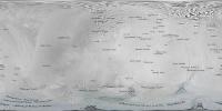
QUOTE (john_s @ Feb 14 2012, 05:50 PM) The fine print explains that they are "planetographic relative to a spherical surface" or something like that. What they mean by "planetographic" is not that surface normals are used to define coordinates (they aren't), but that west longitudes are used (planetocentric coordinate systems traditionally use east longitudes). Thanks much for the elucidation. Here is a link that looks to be consistent with this scenario: http://planetarynames.wr.usgs.gov/TargetCoordinates And here is the result when I refrain from doing the transformation:
Steve -------------------- Steve [ my home page and planetary maps page ]
|
|
|
|
|
|
 scalbers Map Features Overlays on a Cylindrical Projection Jan 28 2012, 07:25 PM
 scalbers I have now a preliminary map of Mars with the feat... Feb 3 2012, 06:25 PM JohnVV nice but a question on the location of 180 in the ... Feb 3 2012, 10:49 PM djellison That's a debate that's been a part of plan... Feb 3 2012, 11:07 PM scalbers John - I had used the 180 center longitude that cu... Feb 3 2012, 11:10 PM JohnVV as djellison pointed out both are right i was just... Feb 4 2012, 12:40 AM scalbers The funny thing is that the quasi-standard way of ... Feb 4 2012, 12:55 AM scalbers Meanwhile, here's the latest with Enceladus. T... Feb 4 2012, 02:22 AM Phil Stooke Don't get too hung up on the question of havin... Feb 4 2012, 03:45 AM scalbers Here's Enceladus with the longitudes a little ... Feb 4 2012, 05:09 PM hendric Someone should make a map with 0 Longitude going d... Feb 9 2012, 09:20 PM
 scalbers Hendric, yes that would be an interesting presenta... Feb 14 2012, 04:28 PM Phil Stooke Re: Post 12.
That is called a Transverse Cylindr... Feb 14 2012, 04:37 PM JohnVV QUOTE Very confusing- it took me a long time to so... Feb 14 2012, 05:56 PM scalbers Next one - here's what I have so far for Io sh... Feb 15 2012, 07:37 PM scalbers And here is Europa with features larger than 40km.... Feb 15 2012, 08:47 PM scalbers And back at Saturn, here are the Mimas features (a... Feb 15 2012, 09:18 PM scalbers Here's Iapetus, with a 5 degree shift that app... Feb 18 2012, 08:12 PM Phil Stooke A very nice project, Steve - I'm enjoying thes... Feb 29 2012, 02:00 PM scalbers Thanks Phil - now 3 years later, I'm checking ... Aug 18 2015, 11:33 PM JohnVV the mosaics here for Vesta line up almost perfectl... Aug 19 2015, 12:10 AM Bjorn Jonsson There are/were several Vesta coordinate systems in... Aug 19 2015, 12:12 AM elakdawalla There are four different coordinate systems in use... Aug 19 2015, 04:24 PM
scalbers Hendric, yes that would be an interesting presenta... Feb 14 2012, 04:28 PM Phil Stooke Re: Post 12.
That is called a Transverse Cylindr... Feb 14 2012, 04:37 PM JohnVV QUOTE Very confusing- it took me a long time to so... Feb 14 2012, 05:56 PM scalbers Next one - here's what I have so far for Io sh... Feb 15 2012, 07:37 PM scalbers And here is Europa with features larger than 40km.... Feb 15 2012, 08:47 PM scalbers And back at Saturn, here are the Mimas features (a... Feb 15 2012, 09:18 PM scalbers Here's Iapetus, with a 5 degree shift that app... Feb 18 2012, 08:12 PM Phil Stooke A very nice project, Steve - I'm enjoying thes... Feb 29 2012, 02:00 PM scalbers Thanks Phil - now 3 years later, I'm checking ... Aug 18 2015, 11:33 PM JohnVV the mosaics here for Vesta line up almost perfectl... Aug 19 2015, 12:10 AM Bjorn Jonsson There are/were several Vesta coordinate systems in... Aug 19 2015, 12:12 AM elakdawalla There are four different coordinate systems in use... Aug 19 2015, 04:24 PM |

|
Lo-Fi Version | Time is now: 23rd September 2024 - 10:02 PM |
|
RULES AND GUIDELINES Please read the Forum Rules and Guidelines before posting. IMAGE COPYRIGHT |
OPINIONS AND MODERATION Opinions expressed on UnmannedSpaceflight.com are those of the individual posters and do not necessarily reflect the opinions of UnmannedSpaceflight.com or The Planetary Society. The all-volunteer UnmannedSpaceflight.com moderation team is wholly independent of The Planetary Society. The Planetary Society has no influence over decisions made by the UnmannedSpaceflight.com moderators. |
SUPPORT THE FORUM Unmannedspaceflight.com is funded by the Planetary Society. Please consider supporting our work and many other projects by donating to the Society or becoming a member. |
|