Venus Map with Feature Names |

Venus Map with Feature Names |
 Feb 25 2012, 08:26 PM Feb 25 2012, 08:26 PM
Post
#1
|
||
 Senior Member  Group: Members Posts: 1669 Joined: 5-March 05 From: Boulder, CO Member No.: 184 |
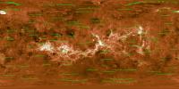
Here is a map of Venus I had put together (recall this collaboration with Emily L. and Calvin Hamilton), with the feature names now added.
Full Resolution: http://laps.noaa.gov/albers/sos/features/c..._180_center.png That's the latest, Steve -------------------- Steve [ my home page and planetary maps page ]
|
|
 |
 
|
|
 |
|
Feb 26 2012, 04:05 PM
Post
#2
|
|
|
Senior Member Group: Members Posts: 1669 Joined: 5-March 05 From: Boulder, CO Member No.: 184 |
Yes, that would be nice to take a look at your higher resolution map. I recall that the data Emily had given me was intrinsically at a higher resolution than what I have used so far.
The features at present are plotted only if larger than 750-1500km, depending on feature type. These thresholds can be experimented with if one wants more names of smaller features. I also posted a transparent PNG file, so the feature overlay can be added to any map: http://laps.noaa.gov/albers/sos/features/overlay -------------------- Steve [ my home page and planetary maps page ]
|
|
|
|
 scalbers Venus Map with Feature Names Feb 25 2012, 08:26 PM
 scalbers Using a shaded relief map we get another view. Mig... Feb 25 2012, 08:41 PM JohnVV if you are interested i have a 13.4 Gig C1 destrip... Feb 26 2012, 12:41 AM JohnVV here is a link to a 16384x8192 pgm
82.0 MB (86031... Feb 27 2012, 05:51 AM JohnVV if you can not get to the 16 k map
some idiot did... Feb 28 2012, 12:01 AM
scalbers Using a shaded relief map we get another view. Mig... Feb 25 2012, 08:41 PM JohnVV if you are interested i have a 13.4 Gig C1 destrip... Feb 26 2012, 12:41 AM JohnVV here is a link to a 16384x8192 pgm
82.0 MB (86031... Feb 27 2012, 05:51 AM JohnVV if you can not get to the 16 k map
some idiot did... Feb 28 2012, 12:01 AM
 Marek Cichanski Hi John,
Would it be convenient for you to upload... Dec 2 2014, 12:35 AM machi I just finished my biggest work ever - topographic... Mar 15 2013, 12:16 PM JRehling This is downright heroic, Machi. I'd like to t... Mar 20 2013, 05:30 PM ElkGroveDan Amazing!
(now Google Earth can add another ... Mar 15 2013, 02:47 PM nprev Stunning, Daniel! Mar 15 2013, 03:23 PM Phil Stooke Yes, that is superb.
Phil Mar 15 2013, 03:50 PM tedstryk Wow. Just wow. Amazing! Mar 15 2013, 05:52 PM JohnVV machi
what did you use as the base imaging data
... Mar 15 2013, 08:13 PM machi Dan, Nick, Phil, Ted
Thanks!
John:
I used le... Mar 16 2013, 03:31 PM JohnVV there is a lot of missing data
the low resoluti... Mar 16 2013, 05:44 PM machi "there is a lot of missing data"
Yes,... Mar 17 2013, 10:39 AM machi Thanks!
Yes, I hope so too.
Venus or especia... Mar 21 2013, 01:07 PM Robotbeat Thanks so much! Incredibly professional, the b... Mar 25 2013, 04:32 PM JohnVV QUOTE Do you have a source for the elevation data?... Mar 25 2013, 05:08 PM Robotbeat Thank you! I plan on using it to make a 3d mod... Mar 26 2013, 12:53 AM JohnVV QUOTE Thank you! I plan on using it to make a ... Mar 26 2013, 01:01 AM Robotbeat Thanks, but I think this will work for now. 256 le... Mar 26 2013, 01:09 AM machi Robotbeat:
If you want elevation data as DEM, then... Mar 26 2013, 02:02 AM machi Because of the practically unlimited account which... Nov 28 2013, 08:40 AM vikingmars QUOTE (machi @ Nov 28 2013, 09:40 AM) Bec... Nov 28 2013, 10:40 PM JohnVV That PDF is 97 meg
so if you have a slow connecti... Nov 28 2013, 09:01 AM machi Yep, sorry for that. Both PDF and jpg are really b... Nov 28 2013, 11:33 AM nprev Fantastically detailed & dedicated work, Danie... Nov 28 2013, 06:03 PM Tayfun Öner Very beautiful and useful. Nov 28 2013, 08:22 PM machi You're welcome!
Regarding to every elevati... Nov 29 2013, 12:18 PM tedstryk Wow, incredible! Brilliant work. Nov 30 2013, 07:57 PM Bjorn Jonsson Wow!!! I almost feel like I'm look... Nov 30 2013, 09:26 PM JohnVV QUOTE (I was never quite able to figure out how to... Dec 2 2014, 01:44 AM JohnVV here is a link to a black and white 64 pixels per ... Dec 4 2014, 02:46 AM
Marek Cichanski Hi John,
Would it be convenient for you to upload... Dec 2 2014, 12:35 AM machi I just finished my biggest work ever - topographic... Mar 15 2013, 12:16 PM JRehling This is downright heroic, Machi. I'd like to t... Mar 20 2013, 05:30 PM ElkGroveDan Amazing!
(now Google Earth can add another ... Mar 15 2013, 02:47 PM nprev Stunning, Daniel! Mar 15 2013, 03:23 PM Phil Stooke Yes, that is superb.
Phil Mar 15 2013, 03:50 PM tedstryk Wow. Just wow. Amazing! Mar 15 2013, 05:52 PM JohnVV machi
what did you use as the base imaging data
... Mar 15 2013, 08:13 PM machi Dan, Nick, Phil, Ted
Thanks!
John:
I used le... Mar 16 2013, 03:31 PM JohnVV there is a lot of missing data
the low resoluti... Mar 16 2013, 05:44 PM machi "there is a lot of missing data"
Yes,... Mar 17 2013, 10:39 AM machi Thanks!
Yes, I hope so too.
Venus or especia... Mar 21 2013, 01:07 PM Robotbeat Thanks so much! Incredibly professional, the b... Mar 25 2013, 04:32 PM JohnVV QUOTE Do you have a source for the elevation data?... Mar 25 2013, 05:08 PM Robotbeat Thank you! I plan on using it to make a 3d mod... Mar 26 2013, 12:53 AM JohnVV QUOTE Thank you! I plan on using it to make a ... Mar 26 2013, 01:01 AM Robotbeat Thanks, but I think this will work for now. 256 le... Mar 26 2013, 01:09 AM machi Robotbeat:
If you want elevation data as DEM, then... Mar 26 2013, 02:02 AM machi Because of the practically unlimited account which... Nov 28 2013, 08:40 AM vikingmars QUOTE (machi @ Nov 28 2013, 09:40 AM) Bec... Nov 28 2013, 10:40 PM JohnVV That PDF is 97 meg
so if you have a slow connecti... Nov 28 2013, 09:01 AM machi Yep, sorry for that. Both PDF and jpg are really b... Nov 28 2013, 11:33 AM nprev Fantastically detailed & dedicated work, Danie... Nov 28 2013, 06:03 PM Tayfun Öner Very beautiful and useful. Nov 28 2013, 08:22 PM machi You're welcome!
Regarding to every elevati... Nov 29 2013, 12:18 PM tedstryk Wow, incredible! Brilliant work. Nov 30 2013, 07:57 PM Bjorn Jonsson Wow!!! I almost feel like I'm look... Nov 30 2013, 09:26 PM JohnVV QUOTE (I was never quite able to figure out how to... Dec 2 2014, 01:44 AM JohnVV here is a link to a black and white 64 pixels per ... Dec 4 2014, 02:46 AM |

|
Lo-Fi Version | Time is now: 24th September 2024 - 12:09 PM |
|
RULES AND GUIDELINES Please read the Forum Rules and Guidelines before posting. IMAGE COPYRIGHT |
OPINIONS AND MODERATION Opinions expressed on UnmannedSpaceflight.com are those of the individual posters and do not necessarily reflect the opinions of UnmannedSpaceflight.com or The Planetary Society. The all-volunteer UnmannedSpaceflight.com moderation team is wholly independent of The Planetary Society. The Planetary Society has no influence over decisions made by the UnmannedSpaceflight.com moderators. |
SUPPORT THE FORUM Unmannedspaceflight.com is funded by the Planetary Society. Please consider supporting our work and many other projects by donating to the Society or becoming a member. |
|