Satellite Feature Maps |

 Unmanned Spaceflight.com > Outer Solar System > Saturn > Cassini Huygens > Cassini general discussion and science results
Satellite Feature Maps |
 Feb 26 2012, 07:00 PM Feb 26 2012, 07:00 PM
Post
#1
|
||
 Senior Member  Group: Members Posts: 1641 Joined: 5-March 05 From: Boulder, CO Member No.: 184 |
Greetings,
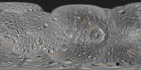
Here's a map with a feature overlay for Mimas:
Full resolution here: http://laps.noaa.gov/albers/sos/features/c..._180_center.png Steve -------------------- Steve [ my home page and planetary maps page ]
|
|
 |
 
|
|
 |
|
Mar 3 2012, 05:37 PM
Post
#2
|
||
|
Senior Member Group: Members Posts: 1641 Joined: 5-March 05 From: Boulder, CO Member No.: 184 |
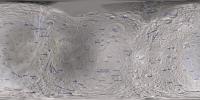
Marc, thanks for the comments and useful feedback. The features that had unspecified sizes in the USGS database (including Izanami and Izanagi) had been omitted from the map. They are there now!
I also did some rotations with some of the linear features names (those Catanae, Chasmata and such).
Full Resolution: http://laps.noaa.gov/albers/sos/features/c..._180_center.png -------------------- Steve [ my home page and planetary maps page ]
|
|
|
|
|
|
 scalbers Satellite Feature Maps Feb 26 2012, 07:00 PM
 scalbers I had earlier shown Enceladus in the post here: ht... Feb 26 2012, 07:42 PM scalbers Next in line is Rhea - here's what I have so f... Feb 27 2012, 09:13 PM MarcF Hey Steve,
Thank you very much for this great work... Feb 28 2012, 10:13 AM scalbers For Titan, please check this thread:
http://www.u... Mar 3 2012, 08:25 PM scalbers This is what I have for Iapetus, with special atte... Mar 4 2012, 04:26 PM
scalbers I had earlier shown Enceladus in the post here: ht... Feb 26 2012, 07:42 PM scalbers Next in line is Rhea - here's what I have so f... Feb 27 2012, 09:13 PM MarcF Hey Steve,
Thank you very much for this great work... Feb 28 2012, 10:13 AM scalbers For Titan, please check this thread:
http://www.u... Mar 3 2012, 08:25 PM scalbers This is what I have for Iapetus, with special atte... Mar 4 2012, 04:26 PM scalbers Here's what I have for a Phoebe feature map so... Mar 16 2012, 06:28 PM
 |

|
Lo-Fi Version | Time is now: 30th May 2024 - 05:02 PM |
|
RULES AND GUIDELINES Please read the Forum Rules and Guidelines before posting. IMAGE COPYRIGHT |
OPINIONS AND MODERATION Opinions expressed on UnmannedSpaceflight.com are those of the individual posters and do not necessarily reflect the opinions of UnmannedSpaceflight.com or The Planetary Society. The all-volunteer UnmannedSpaceflight.com moderation team is wholly independent of The Planetary Society. The Planetary Society has no influence over decisions made by the UnmannedSpaceflight.com moderators. |
SUPPORT THE FORUM Unmannedspaceflight.com is funded by the Planetary Society. Please consider supporting our work and many other projects by donating to the Society or becoming a member. |
|